My latest: https://www.alternatehistory.com/forum/threads/map-thread-xx.492239/page-147#post-21260829@CobaltChloride NOBODY EXPECTS THE NATIONAL SYNDICALIST KINGDOM OF SPAIN!
Well we have done a hell of a job! I don't suppose you do also maps ?
You are using an out of date browser. It may not display this or other websites correctly.
You should upgrade or use an alternative browser.
You should upgrade or use an alternative browser.
Request Maps/Flags/Coats of Arms/Heraldry here, II
- Thread starter Pragmatic Progressive
- Start date
Venditg
Banned
@CobaltChloride it's a well done map!
So the characteristic of mine are below, it's a laundry that you can see.
ASIA
- Thailand should own all of their territorial losses to the French in the map below :

- India should include also Myanmar, Sri Lanka , Maldives , Bangladesh and all of Kashmir, including the territory conquered by China in 1962
- Afghanistan owns Pakistan
- Australia owns both Indonesian Guinea and Papa New Guinea
- Singapore, Brunei , Malaysia and Indonesia ( except the above mentioned Guineas) are 1 country
- Korea is also United
- Manchukuo still exist with the same borders when it was an imperial puppet of Japan

- Inner Mongolia (except the part that belongs to Manchuria) and Tannu Tuva belong to Mongolia
- Greater Tibet and Xinjiang are independent
- Japan still has South Sakhalin and Kuril islands
- The United States of America have absorbed the French territories in the Pacific and the islands around the world except of course those who are considered African islands
- China is under the KMT rule, capital is Nanking
- Syria owns also Iraq Jordan and Lebanon, Hatay
- There is also a independent Armenian state of Cilicia
- An Assyrian State is also independent and was carved up from Turkey
- The United Arab Emirates also own Bahrain and Qatar
- Smyrna and the eastern part of Constantinople belong to Greece
- Russia ( in in this alternate history he's called Commonwealth of sovereign republics) they still own Central Asia, plus Belarus , Ukraine
- Kurdistan is independent
- Armenia is part part of Russia /the Commonwealth of sovereign republics and has the territory that is considered "wilsonian Armenia"

- There is also The sovereign republic of pontus that is also part of the Commonwealth of sovereign republics / Russia
https://www.deviantart.com/altmaps/art/Republic-of-Pontus-724155851
Or this

- Yemen is United
AFRICA
- Modern day Sudan belongs to Egypt
- South Sudan, Uganda, Tanzania and Kenya are the same country
- Zanzibar is independent
- All the colonies and the territories in Africa of Portugal still belong to Portugal
- Portugal also owns the Casamance territory of Senegal
- Spain still owns her African colonies plus Gabon and the Algerian cities Mers al kebir and Oran (so they still own Spanish Morocco and the Spanish Sahara)
- South Africa still owns Namibia and also owns Botswana, Zimbabwe, Swaziland and Lesotho
- Morocco owns Mauritania and is connected by it through the provinces 37, 8 and 45 below.

- French Congo, Burundi, Rwanda and the territory of the Democratic republic of Congo are the same country
- Nigeria is split / balkanized like in the image below

- Tunisia and Libya are united
- French West Africa is United accepted Mauritania that belongs to Morocco
- There is a greater Somalia with all their irredentist territory including Ogaden and Dijibouti
- Eritrea is larger including the Tigray region of Ethiopia
- The rest of Ethiopia is bakanized among ethnic lines (with the Muslim part of Oromia belonging to Somalia)
- Ambazonia is independent (see image below and Wikipedia article)

THE AMERICAS
- Ecuador owns the territory you see below

- French Guiana, Dutch Guyana and British Guiana are the same country
- Canada owns the Dutch, British and French Caribbean. Canada also owns the Falklands
- Colombia still owns Panama but there is also the canal
EUROPE :
- Italy borders should look like the image below

- Bulgaria should look like the image below plus their claims against turkey

- Czechoslovakia has preserved her pre-1938 borders and also owns Silesia
- Poland has still air Eastern borders before the molotov ribbentrop pact plus day territory that they gained from Germany after World War II and what is today the oblast of Kaliningrad accepted the above the above mentioned Silesia
- The Baltic countries are united
- Ireland is United
- Gibraltar belongs to Spain
- Austria and Hungary are united but half of styria belongs to North Yugoslavia (communist country) and also all of Carinthia
- North Yugoslavia includes the Croatian and Bosnia Muslim parts off Bosnia plus the department of Slovenia that isn't under Italian control
- South Yugoslavia only owns Serbia (the part that isn't owned by Bulgaria) , Kosovo, Montenegro
- There is a greater Albania that includes the irredentist claims against Greece plus the part of Macedonia not owned by Bulgaria
- Cyprus belongs to Greece
- Romania is still intact with all of its borders except the part owned by Bulgaria in the previous picture and also owns Szabolcs-Szatmar-Bereg, Hadju-Bihar,Bekes and Csongrad
- Meanwhile Baranya is connected to South Yugoslavia

- Luxembourg, Belgium, Netherlands are the same country and also own there claims against Germany after World War II shown in the in the following links below
https://en.m.wikipedia.org/wiki/Belgian_annexation_plans_after_the_Second_World_War
https://en.m.wikipedia.org/wiki/Dutch_annexation_of_German_territory_after_the_Second_World_War the borders have to be the same of plan A of Bakker-Schut plan
https://en.m.wikipedia.org/wiki/Luxembourg_annexation_plans_after_the_Second_World_War
- Germany is further divided into
Rhenish Republic (except the parts sending to Belgium, Luxembourg and the Netherlands)

Saarland Republic

South Germany that owns Bavaria and Baden Wittenberg
What little is left belongs to North Germany.
- Hamburg and Schleswig-Holstein belong to Denmark
@CobaltChloride it's a well done map!
So the characteristic of mine are below, it's a laundry that you can see.
Last edited:
Venditg
Banned
@CobaltChloride so I asked you so much already but there are corrections/notes/observations I need to make
- Georgia and Azerbaijan also belong to this TL to Russia
- West Timor belongs to Portugal
- Spain is missing Oran and Mers al kibir
- Romania still has the same eastern borders it had before 1939 as below (except Bulgarian Dobruja)
- You can't really see the colonies of Portugal and Spain or other overseas province (like Canadia Carribean) with the color pattern. Can you give each country it own color?
Thanks again in advance!
")
I can probably get to work tomorrow, though I would quickly like to point out that Spain does in fact have Oran and MaK, even if it is a little difficult to see.@CobaltChloride so I asked you so much already but there are corrections/notes/observations I need to make
View attachment 598508
- Georgia and Azerbaijan also belong to this TL to Russia
- West Timor belongs to Portugal
- Spain is missing Oran and Mers al kibir
- Romania still has the same eastern borders it had before 1939 as below (except Bulgarian Dobruja)
If possible all bodies of water black and the borders cyan.
- You can't really see the colonies of Portugal and Spain or other overseas province (like Canadia Carribean) with the color pattern. Can you give each country it own color?
Thanks again in advance!
Venditg
Banned
I can probably get to work tomorrow, though I would quickly like to point out that Spain does in fact have Oran and MaK, even if it is a little difficult to see.
I'm not in a hurry and thanks again man.
I re checked the map and yes they indeed are.
I'm not in a hurry and thanks again man.
I re checked the map and yes they indeed are.
(Used aRCS/RCS where possible).
Last edited:
Venditg
Banned
@CobaltChloride
could you switch the colors of Spain with that former French West Africa and vice versa? Maybe then we can see the Spanish Algerian enclaves.
I would also suggest switching the color of Brazil with the one of Portugal and vice versa again.
Next time would you like to do the alignment-coloring and I also have in mind to "communistify" a coat of arms (and turn it into a flag), can I share it with you in your next reply?? I hope you're not bothered from my many requests but you seem to be one interested in my projects. 😁👍😂
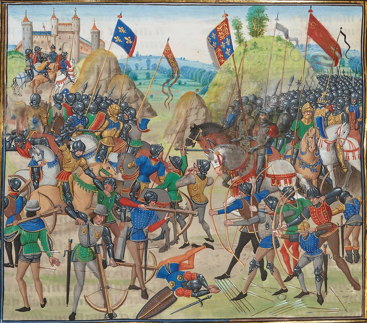
does anyone know the size/ shape of medieval flags? or where to find that out? mainly looking for late medieval european standards and banners but in general it would be nice to know what rules different historical places and times had for flags and flag-like objects. also are standards and pennants meant to be right angle triangles or isosceles?
does anyone know the size/ shape of medieval flags? or where to find that out? mainly looking for late medieval european standards and banners but in general it would be nice to know what rules different historical places and times had for flags and flag-like objects. also are standards and pennants meant to be right angle triangles or isosceles?
you won't really find standardised shape and size before the early modern era (16th-17th century). Even then, it would vary widely between countries and functions. For example french infantry unit standards were squarish and over 2 meters while cavalry ones were less then 1 meter tall, curved and bifurcated.
To give an idea of the wide differences, here are an infantry (left) and cavalry (right) at the same scale of the same period.
Last edited:
does anyone know the size/ shape of medieval flags? or where to find that out? mainly looking for late medieval european standards and banners but in general it would be nice to know what rules different historical places and times had for flags and flag-like objects. also are standards and pennants meant to be right angle triangles or isosceles?
As Marc said, there was no standardization. But I will try to provide some wikipedia links for examples.
Oriflamme - Wikipedia

Flags of the Holy Roman Empire - Wikipedia
Heraldic flag - Wikipedia

Gonfalon - Wikipedia

Pennon - Wikipedia
As for non European, here are some Japanese examples:

Hata-jirushi - Wikipedia

Nobori - Wikipedia

Sashimono - Wikipedia

Uma-jirushi - Wikipedia
Turko-Mongol:

Tug (banner) - Wikipedia
you won't really find standardised shape and size before the early modern era (16th-17th century). Even then, it would vary widely between countries and functions. For example french infantry unit standards were squarish and over 2 meters while cavalry ones were less then 1 meter tall, curved and bifurcated.
To give an idea of the wide differences, here are an infantry (left) and cavalry (right) at the same scale of the same period.
View attachment 598964
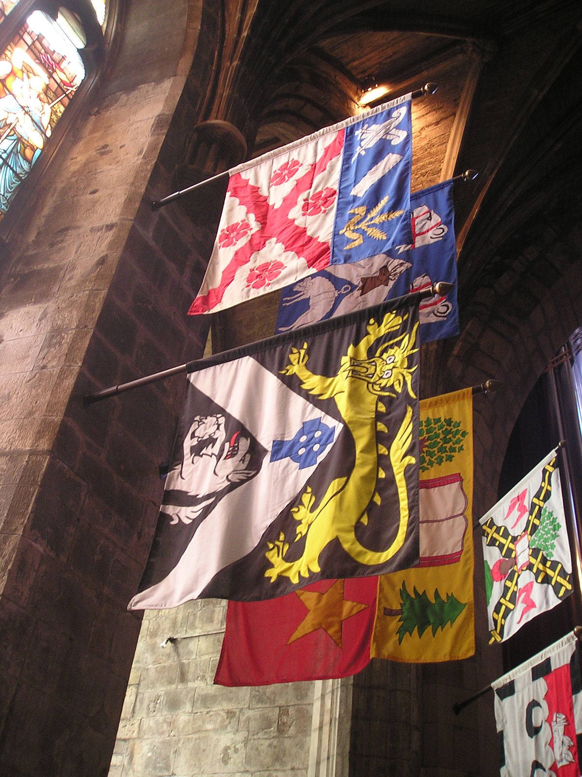
damn, i wanted to make to scales templates in paint. what about the sizes of specific flags from specific places. like either described in a primary source or found in the field and then measured. 1400s france, england and scotland would be cool uwu. also was there any consensus(s) for the ratios then? wikimedia commons has templates that arent used on any english page, and one that is only used on a user page. is there a modern typology for oldschool flags like an okeshott but for flags?As Marc said, there was no standardization. But I will try to provide some wikipedia links for examples.
Oriflamme - Wikipedia
en.wikipedia.org
Flags of the Holy Roman Empire - Wikipedia
Heraldic flag - Wikipedia
Gonfalon - Wikipedia
Pennon - Wikipedia
As for non European, here are some Japanese examples:
Hata-jirushi - Wikipedia
Nobori - Wikipedia
Sashimono - Wikipedia
Uma-jirushi - Wikipedia
Turko-Mongol:
Tug (banner) - Wikipedia

damn, i wanted to make to scales templates in paint. what about the sizes of specific flags from specific places. like either described in a primary source or found in the field and then measured. 1400s france, england and scotland would be cool uwu. also was there any consensus(s) for the ratios then? wikimedia commons has templates that arent used on any english page, and one that is only used on a user page. is there a modern typology for oldschool flags like an okeshott but for flags?
<the aforementioned template that exists without elaboration. also that triangle thing i really need to know, wikipedia has confliction information on it, does it just depend?
In the Heraldic Flag page and Pennon page some sizes are specified. Other than that I can't really help.
what about the sizes of specific flags from specific places. like either described in a primary source or found in the field and then measured. 1400s france, england and scotland would be cool uwu.
standardization started at the same time as the creation of professional armies (as opposed to levy raised by noblemen) so that's the 16th-17th century onward. In those cases, you can often find contemporary written regulations that gives precise measurements. Otherwise, looking up flags on museum websites might give you an idea of some surviving flags as artefact descriptions often gives measurements.
also was there any consensus(s) for the ratios then?
Not between countries or branches but usually units within a given branch would all have the same measurement. General shapes were also common across countries so that the flags of infantry units of many countries were squarish though exact ratio and overall size might vary.
In general, FOTW's online Dictionary of Vexillology might help with some definition of terms (ex: pennant vs wimpel) though specific terms can have different meaning depending on language or country.
Dictionary of Vexillology
Last edited:
This should do the trick.@CobaltChloride
could you switch the colors of Spain with that former French West Africa and vice versa? Maybe then we can see the Spanish Algerian enclaves.
I would also suggest switching the color of Brazil with the one of Portugal and vice versa again.
Next time would you like to do the alignment-coloring and I also have in mind to "communistify" a coat of arms (and turn it into a flag), can I share it with you in your next reply?? I hope you're not bothered from my many requests but you seem to be one interested in my projects. 😁👍😂
Hi i dont know if anyone could do this, but a map of the USA at independence, but with New York split into Long Island south of West Chester and Rockland and Richmond county attached to New Jersey. Also Virginia independent, but with Connecticut's Western Secession and everything north of it remaining part of the Union.
Venditg
Banned
@CobaltChloride niiiiiiiiiiccccccccccceeeeeeeeeeeeeeeee!!!!!This should do the trick.
View attachment 599013
Can anyone make a flag for the Kingdom of France with the Vichy ax?
The flag should look like this but with darker colors

It should include this Vichy ax with the words "Travail, Famille, Patrie"
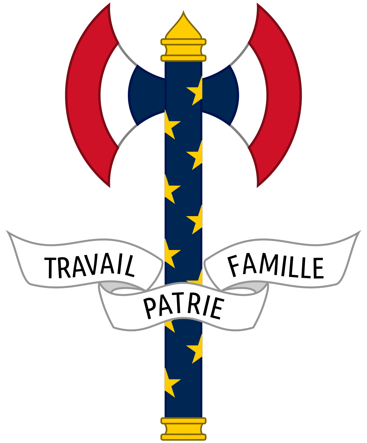
The flag should look like this but with darker colors
It should include this Vichy ax with the words "Travail, Famille, Patrie"
Can anyone make a flag for the Kingdom of France with the Vichy ax?
The flag should look like this but with darker colors
It should include this Vichy ax with the words "Travail, Famille, Patrie"
Try placing the two sides of the ax above the crown and that's about it.
Last edited:
Share: