Rememberences of Map Contests Past

BryanIII:

*juuj first!!*

motf156___the_doggerlandic_return_by_bryaniii-db8rqe9.png


*larger, more detailed version to be found here: http://bryaniii.deviantart.com/art/MotF156-The-Doggerlandic-Return-679858785?ga_submit_new=10:1494453243&ga_type=edit&ga_changes=1&ga_recent=1*

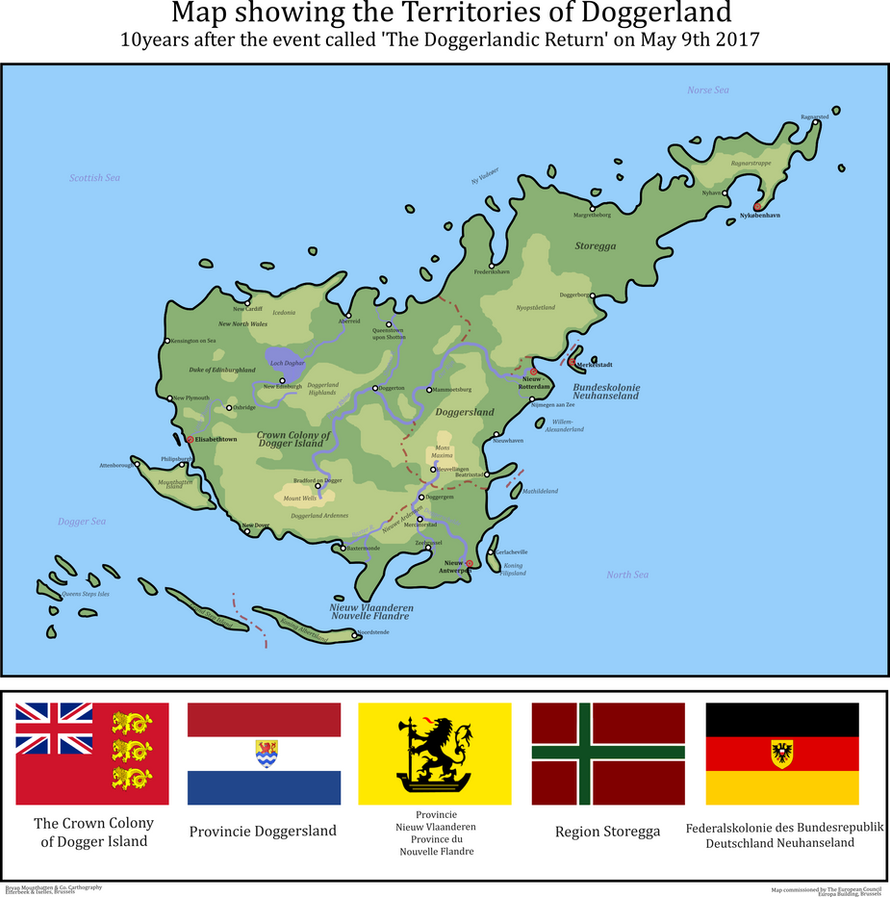
For some reason unknown to humanity and science alike, the submerged island of Doggerland instantaneously rose up from the depths of the North Sea to retake its position it had at the beginning of the Holocene. The subsequent displacement of water pushed boats in area away from the island and a small tidal wave did some minimal damage to British, Dutch, German and Danish shores (the small damage was almost exclusively suffered by the Frisian Islands).

Not knowing what hit them the UK, Denmark and the joint Belgian-Dutch Admiralty send both war- and research vessels to the area. The involved parties met in Dover a few months after to share information and compare finding and maps. In October of 2017 British research ship Boaty McBoatface -Uhm... I mean RRS Sir David Attenborough ofcourse :p- made the first landing on the smaller island just out the SouthWestern shore of the main island and after a few expeditions concluded that no humanoids were transported, only the wildlife. The Crew were the first Humans to see Mammoths in 4000 years.

The UK, with the Brexit being in progress, didn't feel the need to go the European summit in Brussels to discuss the issue and went along with colonization before everyone else. Meanwhile in Brussels there was nothing much they could do against the British but asked however to, for now at least, respect the former border between British and Dutch Territorial waters (which they did). An agreement on resettlement (note here that most of the EU doesn't call it colonizing) was largely found and after Germany was persuaded by giving it some islands which would normally go to Denmark, the green light was given for the nations involved to go and claim they're lands.

The solo-colonization by the UK had as an effect that the Brexit was speeded up by the EU and by March 2019 it was signed. One of the last Treaties that had been signed was an document defining the final borders between the UK and the European countries. Scotland had also decided to remain with the Brexiting UK, largely because it has been bribed into submission with a large portion in the NorthWest of the British Colony that is entirely under the control of Scottish Parliament.
 
Kaiphranos:

Three and a half billion years in the future, a matrioshka brain is running a simulation of the rise of one of its creator species, when a minor error causes a hyperspherical cross-section of the simulated world to be temporally transposed by 2^10 cycles...

2017. At first they thought it was a summer thunderstorm. The first thing everyone noticed was a great booming sound, like a clap of thunder but larger, as two masses of air at different temperatures and pressures were suddenly brought in contact with each other. Those who were outdoors could see a strange roiling in the sky, as clouds formed, joined, or dissipated. One or two people near the boundaries of the sphere saw features seem to vanish in an instant - trees, roads, telephone wires. Later, they were able to trace the boundaries of "The Zone" by finding objects which had been bisected by the transposition. Staff and campers at Box Canyon Ranch noticed as the power went out. But it was several days before anyone grasped the truth - that their little circle of northern New Mexico had been thrown back in time.

Once this hypothesis had been reached, a party from Box Canyon Ranch set out within a few days, following the Chama River down to the Rio Grande, then heading up into the hills where Santa Fe should be, to determine if it might be possible to make contact with American or even Spanish colonial authorities. They found nothing. A second party set out a few days later, headed west...

993. The strangers had come down from the high country to the east, Qoyanomtiwa's scouts had reported, though they did not dress like easterners. They were oddly pale, and most curious of all, some were being carried by elk without horns. No one seemed to have guided them, but somehow they had found their way to the Great House. Qoyanomtiwa pondered this, and at last he shrugged. "Let us go and meet these strangers," he said. "Maybe they are Pahana, maybe not. We shall put them to the test, and if they fail, we shall treat with them as with any other men or women."

2017. "It's not much like how I remember it," Rick said. "It's bigger, but smaller at the same time." It didn't even look much like the reconstruction in the National Geographic they'd found in the library--most of Chaco Canyon didn't seem to have been built yet. But there was Pueblo Bonito, sure enough, and not just the ruins Rick had visited last fall - the stone walls stood several stories high, and right now they seemed to be bustling with people.

"Look," said Carla. "Someone's coming out." Indeed, a group of several people was emerging from a doorway, though only one seemed to be carrying a weapon.

"Alright, let's not get any closer. Wait here for them."

993. Qoyanomtiwa surveyed the strangers. There were five of them, but the scouts were correct - each of them seemed to be seated on an elk of some sort. As he watched, the strangers climbed down off these elk, and stood. They did not seem to be carrying spears or other weapons that he could see, though who knew what powers they might have if they could command these beasts?

"Lomankwa, tell them to come no closer," he said to the shaman.

2017. Rick watched as one of the delegation drew out a small pouch of white powder, and sprinkled it in a line on the ground. "Let's leave the gifts here and back off a bit," he said, watching the shaman's gestures. Carla nodded, deposited the "gift package" they'd assembled at the Ranch, and stepped back a few paces.

993. "I think they might be offering a trade," said Macatoiniwa. "Remember the men from the south, five years ago, who brought the green birds and the shells?"

"Yes, I remember," Qoyanomtiwa replied. "In that case, let's see what they have to offer." They advanced to where the strangers had laid their bundle. A square of fine red cloth, wide as his arm, lay on the ground. On it were knives that glinted like the sun on water, plates and dishes with strange intricate designs, several garments of white cloth, jewelry of silver and turquoise, and a pile of shining disks the size of his hand. "These seem like fine goods," he said to Macatoiniwa. "Let's see if we can come to an arrangement..."

By the time the error was noticed, milliseconds later, several dozen processing cycles had passed. A new hybrid culture was blossoming across the affected area, as the ancestral Puebloans adopted and assimilated these strange newcomers. The area had already been headed for an era of rapid growth and development due to favorable climate conditions, but the new crops and livestock seemed likely to extend it further and faster. Already, trade networks were forming, east to the Mississippi Valley and south into Mexico.

A quorum was called to determine whether to end the counterfactual scenario or to let it continue...

motfb-png.323039
 
theman7777:

atlantis1-png.322670


Sometime between December 31st (1913) and January 1st of 1914 a new island rose from appeared in the middle of the Atlantic ocean. This was followed by minor tsunamis impacting Western Europe, and the Eastern Seaboard of the United States. What became clear was that there was now a new landmass that had emerged in the Atlantic ocean, inhabited by a human civilization. The people on the island had a primitive culture reminiscent of Ancient Greece and the Mesoamerican civilizations, which quickly gained the Island the name "Atlantis". Shortly after it's appearance, many European powers, alongside the United States began colonizing the island. In 1918 a formal Conference was held in Rome, similar to the Berlin Conference of 1885. It determined the zones of control over the island. As the Europeans expanded inward, they encountered increasingly hostile Atlanteans, who were armed by various competing powers and encouraged to revolt. Eventually, Japan, Itlay, Spain, Portugal, Brazil, the USA, Germany, France, Russia, Canada, and the United Kingdom all controlled or claimed territory in Atlantis.
 
MotF 157: From Here to Eternity

The Challenge

Make a map of a region, or the world, in the near future. By near future, I mean sometime in the next 100 years. It could be anywhere, not just on Earth, and not necessarily just in our timeline.

The Restrictions
There are no restrictions on when the PoD of your map should be. However, it should be anywhere between now and May 21st, 2117. Fantasy, sci-fi, and future maps are allowed.
 
Only two this time. First,

Kaiser_Jaeger:

When Worlds Collide
venusmap-jpg.324605


"We must look to the stars to save humanity" - Harold Musk[1] to the Sol Council[2] 2050

The year is 2080. A new day. A new year. Luna had been ruled unsuitable for terraforming and was spotted with several small domed mining towns. Mars was the first true target for human colonization. By the time the scientist of Earth had developed the terraforming techniques necessary, their goal had drifted dangerously close to the asteroid belt. The extra distance from the sun has made Mars unsuitable for the massive transfer of water necessary for the terraforming process.

Humanity set their sights on another goal. Venus. Much like Mars, Venus had drifted farther from the sun, although not as far. This brought Earth's twin into the edge of the habitable zone. But it moved closer still. As the planet drifted, its speed of rotation increased. When Venus was within the habitable zone, its day-night cycle lasted 30 hours. The heavy and sulfuric atmosphere had been pulled away, leaving a thin atmosphere. The surface of Venus was now averaging 100 degrees.

Massive water tanks were filled from the oceans of Earth. The tanks were sent skyward attached to rockets from space programs around the world. These tanks jettisoned their payloads over the surface of Venus. Over the next 10 years they labored. And Earth's twin continued its path away from the sun. In 2090 the event known forever-after as the Joining occurred. Venus had drifted into the outer orbit of the Earth, and stopped its march across the cosmos. It orbited the Earth a mere 20,000 miles from Earth's own moon. This made transport between planets much easier. In 2094 the first human was born born on the surface of Venus. By 2100 Venus had taken on 5 billion inhabitants.

It had always been the intention that the people of the newly inhabited planet govern themselves when they were ready. The first to break away from its Earthbound rulers was the North American state of Asteria. The Anarchist Black Army of Asteria swept through the islands. Every government officer was given a choice, join or die. Some chose to die but many joined the army. The Anarchy of Asteria was established on April 20th 2110. The twin worlds were shocked that an Anarchist Revolution could do as well as it did, and that the country hadn't devolved into chaos.

The Soviet State of the Ishtar Terra was peacefully released by the Union of Soviet Spaceward Regions and formed the Ishtar commune. The Mediterranean Space Alliance granted its province of Tellus Regio almost full autonomy. The new nation would use the same currency and share a space program. The Promethei Coalition formed from the ashes of Promethia when the East Asian space program fell apart due to lack of funding. The last to decide their fate was the Reich of Venusia. The broke off from Germany and the North European Space Bloc in 2115 when their political and scientific views began to differ from their homeland. The Chancellor of German Venusia was declared the new Kaiser of the Reich of Venusia. In 2116 these states were all given seats at the Sol Council

Two years have passed since the formation of the five new nations. Tensions between them are rising. Amnesty between the nations of Earth are at an all time high. The members of the Sol Council have tried diplomacy. People around the globes are waiting in fear, not knowing when the first great war of the new century will begin.

[1] Elon Musk's grandson, head of NASA and American Ambassador to the Sol Council
[2] UN like group that contains a representative from each space faring country in the solar system

Bellow are the approximate spheres of influence of each space union after the draining of the oceans. The dark green is the African-Arab Alliance and light blue is the South American Space Association.

space-alliances-png.324670
 
Now Jockehh:

finished3_by_jockehh-dbaxbkt.jpg


Egypt in 2052 - Economic growth and prosperity in the 2020s due to a closer relationship with the Russian federation made Egypt into the most powerful country in the region. They participated in mining the first Asteroid along with Russia in a space mission headed by Russia aswell. This changed politics on earth, the extreme wealth that could be made from mining asteroids quickly threw all of the major powers into a new space race, which even the nordic countries participated in. Russia was the first to set up a colony on the red planet, but it didn't take long until independent corporations started doing this aswell. The united states of America Bought large territories off of these corporations along with India and the nordic countries. However the exact border was never made clear and a large region ended up disputed where all 3 of these are building inside. China originally settling their own small area in the north soon bordered new large corporative colonies which had to be bought, if they managed to encapsule the chinese colony it would prevent future growth.

Egypt aquired its first colony from Russia in 2041, for a relatively cheap price aslong as Russia had rights to work, travel and use the territory aswell. The area was settled by just a few thousand people, mostly Russian, but after a few years an immense ammount of egyptian settlers were sent and the number grew. Allthough the colony being very expensive, it was made into a national pride and mission to further the advancement of humanity.

I had to scale the map down. full sized map here
 
Last edited:
Quite a few of the maps in the earlier pages are missing. :(

I'm working on it: a lot of the links got broken with the forum update, and I'm restoring those a few at a time. I will try to spend more time on it after I get through my current backlog of map requests.
 
Quite a few of the maps in the earlier pages are missing.

:(

I'm working on it: a lot of the links got broken with the forum update, and I'm restoring those a few at a time. I will try to spend more time on it after I get through my current backlog of map requests.

More permanent losses came from the fact that Imageshack seems to have changed it's format or something: images stored there a decade or so back are unreachable now, as far as I can tell.
 
Kaiphranos:

An uneasy quiet has settled over the wine-dark seas of the eastern Mediterranean. The last few centuries have seen a blossoming in art and literature, philosophy and science--but now that blossom has come to fruition, and the fruit may be Eris's apple of discord.

It has been centuries since the legendary craftsman Daedalus fled to Sicily, but his descendants in Magna Graecia have not forsaken his heritage. Led by Syracusae, they hold the balance of power between Carthage and the Roman Republic--a balance maintained by the work of Archimedes and his disciples. No hostile ship can pass the defenses of Syracusae harbor--the catapults, the ship-shakers, and most terrifying of all, the deadly burning-glasses.

The wars of the Diadochi have ground to a halt for now. Philip of Macedon faces rebellion in the city-states of the south. Inspired by Plato's Republic, many are led by so-called philosopher-kings, each of whom denounces the others as mere tyrants. But despite war and revolution, your polis will see true Utopia in your lifetime, citizen!

The Seleucids still rule the largest empire, and must face the problems that come with that. Unsatisfied with the war elephants that have been used for generations, a few artisans in the western part of the Empire have begun experimenting with engines to rival the "Helepolis" of old--great armored machines that will be of use in the open field and not just the siege.

In Egypt, the Library of Alexandria has flourished under the Ptolemaic dynasty. Philosophers and scientists of all stripes flock to the city, and generous funding has fed the creative fires. Lately there has been much discussion of the device they call the aeolipile, and its potential applications. Meanwhile, other philosophers transcribing the contents of the Library into a vast "knowledge engine" for easier access. And perhaps similar devices could be used to aid in certain calculations...

However, everyone is disturbed by the silence out of Rhodes. The island has long been famed for its merchant fleet, and for the automata built by its craftsmen. But in recent years, traders have been less frequent, and there are rumors that the Rhodian has been sinking any ships that venture too close to the island. Still wilder rumors speak of the great Colossus that bestrides the harbor, and of metal man Talos, crafted by Hephaestus himself to guard the island of Crete. And only the court of Ptolemy knows the truth about the strange ship without a crew that has lately arrived in Alexandria, or the whirring, clanking figure who stepped ashore claiming to be an ambassador from the Automatic Polis of Rhodes...

(Author's Note: This could just as easily be called Archimedes-Punk or even Hellenistic-Punk, but the idea came to me as Antikythera-Punk, so that is what I have named it.)

attachment.php
I noticed that original map is still up, but I can't see it here.

 
I noticed that original map is still up, but I can't see it here.


Yeah, that's what I was talking about in terms of broken links. I'm slowly working my way from earlier to later posts, fixing those links where the map still exists.
 
Rubberduck3y6:

On the morning of Friday 24 June 2016, Europe awoke to shocking, confusing and distressing news coming out of the United Kingdom. Rumours had been circling around the Internet and media outlets overnight that Brexit was happening and that the British people had chosen to leave. Then, nothing. Just as an official announcement to proclaim the results was expected, all communications from the UK suddenly stopped. People close to the British coast and living near the intra-Irish border reported a blindingly bright light and then complete darkness. As dawn broke it became clear that the British had truly left - all houses, factories, farms and roads had disappeared and been replaced with miles of unbroken woodland, and Low-lying areas which had been drained and reclaimed from the sea generations ago were now inundated. In fact, the only humans to remain where those who were those who were immigrants to Britain, foreign tourists and military personnel.

The strange and unsettling events of that fateful day are now a century past and Britain is now a fractured land. Britain's European neighbours' initial interests in the island were to secure their own maritime frontiers through a series of installations along the North Sea and Channel coasts. These have since grown into significant settlement areas with many of the "New Britons" speaking French, Dutch or Flemish as their first language. Further inland, the United States, China and Russia compete to extract the replenished natural resources, with the first's pre-existing military bases having provided them with an early advantage, although the Chinese, and now the Russians have caught up fast. Between these European "colonies" and superpower mining outposts lie the polities established by those who were left by the Event, the most numerous of whom are the Poles and various Asian communities (Indians, Pakistanis and Bangladeshis). Of note is the refugee-established nation of Zanggal on the south coast and the numerous multicultural independent cities. Of course, the one thing all these polities have in common is their quasi-legal status: shortly after the Event, the UN declared the territory of the United Kingdom to be an international scientific reserve and prohibited any nation from claiming land or establishing a permanent population on the islands, thus giving them a similar status to that of Antarctica. This declaration had very little practical effect however, and is now regarded as little more than a trivial curiosity. In fact most New Britons give it as little thought as they do to whatever happened to those than voted to leave 100 years ago.

brexisot_by_rubberduck3y6-db9z6vv.png
I'm puzzled as to why Nepal of all places is noteworthy enough to get a unique color, while in contrast, the various nations of the African continent are all grouped into a single color...

Oh, and climate change has run it's course, huh...

Thanks for reposting these good maps - they're well-made.
 
Tsar of New Zealand:

A rather bog-standard Nuh Zillund Stronk AH: here the desires of expansionist figures in the late nineteenth century come to fruition, with New Zealand passing the Confederation and Annexation Bill of 1883 and amassing a vast network of Pacific colonies - if often in name only as a proxy for Britain - by the end of World War One. The map is intended as a supplement to a textbook on New Zealand history, demonstrating the apex of Wellington's influence. Full size viewable here.

the_prussia_of_the_south_pacific_by_bolshiekiwi-db8584k.png
Hail Zealandia! Zealandia Rules the Waves!
 
I noticed that original map is still up, but I can't see it here.


Man, that's an old one - I still like the ideas, but the map itself really doesn't measure up to my current standards. Maybe I should do a remastered edition someday...

Anyway, at some point I went back and replaced some of the broken links to my old maps with images hosted on my blog (where I suppose they are in the clutches of Google one way or another).
 
Last edited:
My apologies, I've been distracted by other stuff and haven't made much progress on fixing the links that can be fixed. Hope to get some more done this weekend!
 
Did MoTf15-19, since I didn't remember what I'd fixed last. Made sure to copy the link so I can resume where I left off...

In any case, here is:

MotF 158: Antiquated Union

The Challenge

Make a map of a union of two or more countries that weren't allied (or at least weren't one country) in our timeline.
 
Zagan:

Hungary-Romania
(1919-1949)

România-Ungaria
Magyarország-Románia


Flag of Hungary-Romania
:
motf158-hungary-romania-flag-png.327070


motf158-hungary-romania-map-png.327071


Capital: Cluj / Kolozsvár (46°46′N 23°35′E, also capital of Transylvania)
- Romania Proper: București
- Hungary Proper: Budapest
- Slovak Autonomy: Nitra

Official languages: Romanian, Hungarian, Slovak (in the Slovak Autonomy)

Ethnic groups: Romanians (51%), Hungarians (29%), Slovaks (8%), Ruthenians (4%), Germans (2%), Bulgarians, Russians, Turks, Tatars, Serbs, Croats, Armenians, Greeks, Albanians, Jews, Gypsies, etc.

Religion: Orthodox (54%), Catholic (35%), Protestant (8%), Jewish (1%), Muslim (1%), etc.

Demonym: Hungarian-Romanian

Government: Asymmetrical sui-generis federal kingdom
King: Carol II / I. Károly

Legislature: Parliament
- Upper house: Senate
- Lower house: Chamber of Deputies

Formation:
- Personal Union (under King Ferdinand I of Romania): 1919
- Real Union: 1922

Area:
- Total: 512,000 km² (198,000 sq mi)
- Water: 3%

Population:
- 1940 census: 33,387,590
- 1949 estimate: 35,100,000
- Density: 68.5/km² (177/sq mi)

Currency: Leu (100 Bani)


POD: 1917


Bruce: Well, that's one way to solve the Transylvania problem...
 
Last edited:
Extra notes on Hungary-Romania:

Let's say that WW1 progressed somehow differently (especially in the East):
  • the Balkan Campaign was won by the Central Powers; the Salonika Front (and the Serbian army) collapsed completely;
  • Romania did not sign a separate peace; the Romanian army, government and king retreated into Bessarabia, then Transnistria, then Ukraine proper and finally the Crimea;
  • Italy was more successful against Austria-Hungary;
  • Ukraine and Poland were more stable and able to feed Germany better during the blockade;
  • the American intervention in France was more important in the winter of 1918/1919; subsequently, Wilson had a larger say at the Peace Conference;
  • in the spring of 1919, WW1 ended with an Entente victory;
  • instead of peace conditions being simply presented to Germany, there were true peace negotiations during 1919;
  • Austria-Hungary collapsed anyway and separated in its two halves; the Habsburgs were toppled;
  • the Ottoman Empire collapsed as in OTL;

Paris Peace Conference:
  • Germany lost Alsace-Lorraine to France, Posen to Poland, plebiscites scheduled for other areas;
  • Austria lost Lodomeria to Poland, Galicia to Ukraine, Bukovina to Romania, Dalmatia to Italy/Croatia, ethnically Slovene areas to Slovenia, ethnically Czech areas to Checho-Slovakia, plebiscites in certain areas;
  • Hungary lost ethnically Slovak area to Czecho-Slovakia, ethnically Romanian areas to Romania, ethnically Serb areas to Serbia, etc, plebiscites in certain areas including the Vierburgenland;
  • Bulgaria lost everything as in OTL;
  • the Ottoman Empire was dismembered as in the OTL treaty of Sevres;

After the Peace Conference:
  • the Turkish nationalists lost the war against Greece, Armenia and the rest of the Entente; the Straits zone became a LoN Mandate;
  • fighting continued with Soviet Russia; Finland, Estonia, Latvia, Lithuania, Poland, Romania signed a common peace with Soviet Russia, resulting in borders further east than in OTL (the Ukraine up to the Dniepr to Poland, Transnistria and Pokuttya to Romania, etc);
  • Yugoslavia was not formed; Slovenia, Croatia and Serbia remained separate; they were unable to take lands from Hungary;
  • Italy got more lands in the Adriatic; no fascism;
  • Czecho-Slovakia was significantly smaller than in OTL and did not have Carpatho-Ruthenia;
  • After the Romanian conquest of Hungary in late 1919, King Ferdinand I of the Romanians was offered the Hungarian Crown which was duly accepted; Romania and Hungary enterned a Personal Union;
  • Austria acceded to Germany via a plebiscite;
  • the curious border between Serbia and Croatia were settled after a short war;

Later:
  • Romania and Hungary entered a Real Union and got rid of the difficult borders and enclaves in Transylvania (the whole region between the Tissa and the Carpathians became a kind of condominium, attached to both Romania and Hungary);
  • Germany annexed rump Slovenia as an Autonomous Region;
  • Czecho-Slovakia collapsed and separated in its two parts; Czechia was annexed to Germany and Slovakia to Hungary, both as Autonomous Regions;
  • Albania and Croatia came under Italian influence and became Viceroyalties (Dynastic Union);
  • The Straits LoN Mandate came under increasing Greek influence;

Structure of Hungary-Romania:
  • Romania (Bucharest)
    • Romania Proper (Bucharest)
    • Transylvania (Cluj)
  • Hungary (Budapest)
    • Hungary Proper (Budapest)
    • Transylvania (Kolozsvár)
    • Slovak Autonomy (Nitra)

WW2 started in 1946 and Hungary-Romania got partitioned in 1949... But we are here for a map contest, not for a full-fledged TL. If I ever write it, I will PM you with a link.
 
Top