Rememberences of Map Contests Past

Krall:

The decolonisation of India was a complex and chaotic affair - perhaps appropriately, considering the region had the size, population, and diversity (religious, ethnic, and political) of a continent. Though the simplistic "Two-Nation Theory" - by which India was considered to consist of two nations; one Hindu, one Muslim - was popular among Muslim Indians for a time, such an easy solution quickly proved to be impractical. The rise of groups such as the Pashtun Khudai Khidmatgar in the Northwest Frontier Province brought the theory's popularity to an end, as the KK and the various Muslim movements it inspired believed India was a multitude of nations based on ethnicity, rather than a pair based on religion. Though the All-India Muslim League, which believed strongly in the Two-Nation Theory, attempted to gain power by promising support for the British during WWII in return for recognition of the League as representing all Indian Muslims, this ploy failed due to their lack of support from large portions of the Muslim population and the impracticality of their ideal independent "Pakstan".

The question of what to do with India's numerous, nominally sovereign Princely States was perhaps one of the simpler ones that faced British administrators. It was decided that they would have the option of joining a newly united India on their own terms once a united India had been established or remaining independent. It was the latter that the Maharajadhiraj of Kashmir and Jammu - Hari Singh - chose for his country. Rather than join with India, he hoped that his nation could remain neutral and independent; an Asian Switzerland nestled in the mountains of the Himalayas, prosperous and respected yet without affiliation or fear of war.

In order to attain such a status, Kashmir and Jammu was kept isolated - a hard thing to do in the midst of a Cold War, and stuck between the opposing juggernauts of India and China. Kashmir had almost no transport links to other countries, and international trade with Afghanistan and India was deliberately avoided in fear of drawing China's wrath (though Kashmir's approval of China's entry to the UN and the subsequent peaceful negotiations over disputed territory in Aksai Chin curtailed such fears somewhat). Relations between Kashmir and its neighbours was generally warm, but very limited, as it refused almost all political and economic association.

However, Kashmir's isolation helped preserve the state as a peaceful yet underdeveloped country during times when those around it underwent chaos and strife. Afghanistan, looking to throw its weight around after joining with the US, aided Turkic Muslim rebels in the USSR and China. India remained generally unaligned - save for its antagonistic relationship with China, with whom they had numerous border disputes, and numerous border skirmishes as a result - and later suffered as unrest among its Sikh population snowballed into a civil war, leaving India fractured, with a rump federation having lost much of its territory. Though political unrest in these newly independent countries would eventually begin India's reunification, Kashmir was glad to have been spared the chaos.

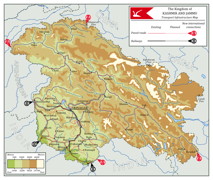
As the 21st century loomed ahead, the regional situation had been stable for quite a while, and without fear of invasion the people of Kashmir and Jammu were free to agitate for domestic reforms. The Kingdom gradually changed, with more and more power being devolved to democratic bodies, and franchise being extended across ethnicies, gender, class, and religious groups. The now modernised government of Kashmir now sought to modernise the country's economy. Being on generally good terms with its neighbours Kashmir was able to quickly expand their trading relationships with them, and by 2000 plans had been put in place to expand Kashmir's transport infrastructure and make several new international connections both by road and by rail.

Most of the population was concentrated in the south of the country, whereas the mountainous north was sparsely inhabited, therefore much of the development was concentrated in the south, being centred around the capital city of Srinagar. The short, simple railway line that ran though the capital was to be extended, covering a great deal of the densely populated south, connecting to Indian and Afghanistani rail networks, and providing the basis for further expansion with a line through the mountains to Kargil in Kashmir's hard to access northern areas. Roads were also to be expanded - or often just properly paved - providing ease of movement all throughout the country, as well as connecting to China along the Sênggê river in the East, and through the Khunjerab Pass in the north.

With its improving infrastructure and decreasing isolation Kashmir is on the verge of a great change, though the modern democratic government still maintains the country's now-traditional neutrality, entrenching the country's reputation as the Switzerland of Asia.

the_rest_is_worthless_by_kurarun-d86ng52.png
 
This one, on the other hand, sort of annoyed me, but since it's tied for first place I cannot in good faith leave it out. :openedeyewink:

Gryphon:


(With many thanks to Georgepatton, who inspired the original idea and wrote this lovely desription.)

The Unorganized African Territory of the United States

After the end of the Civil War (1861-1867), the United States was confronted by two intractable problems, which it seemed impossible to solve simultaneously. First was the problem that confronts all states in the aftermath of domestic bloodletting: the defeated. The great masses of ex-Confederate soldiers and supporters, disenfranchised and dispossessed by an embittered North, swarmed disconsolately across the ruined South, and there were many yet still willing to fight and die on their feet, rather than strangling in the mud an inch at a time.

Second, of course, were those who the Confederates had fought to hold in chains: the negro. Freed from his chains, and armed with the ballot, the rifle, and the strong right arm of the Federal Marshal, prosperity might at last be within his grasp. But, of course, it was not to be, for hearts are not so easily won as wars.

Terrorism, cycles of killings and revenge killings, race riots, bread riots, labor riots, just plain old riot riots: there was no end to it. The Hamlin and Davis administrations grappled fruitlessly with the problems, and as the body count mounted, the public began to ask when, exactly, peace was scheduled to arrive.

The answer would come from a much unexpected source: Abraham Lincoln, who had retired from politics to repair his shattered health and family after the War, returned to answer the national cry for peace once more. He looked across the Atlantic Ocean, to the continent from which all this sorrow had sprung: Africa.

Lincoln, who had once thought that the races might live in harmony in the United States, sorrowfully returned to his belief that separation was the only true path to peace. But that was not all bad, he reasoned, for the American negro, by his residence upon that continent, had indelibly acquired respect for the great virtues of the land: freedom, liberty, democracy, education, and hard work. And the African negro languished in poverty, ignorance, slavery. The great civilizing mission of the United States could be brought back to Africa, bringing peace and prosperity to two lands in the same solution.

But the great masses of American negroes had no great skill at arms or settler organization. Some class of men with those skills would have to lead them. Who better, suggested General Sheridan, than that other people without a future in America: the Confederate veteran?

And so it was that black and white at last found unity of purpose, in the Great Grey Fleet, which hurled itself upon the African coast in 1879. By dint of blood and iron, they forged a great country upon that continent, bringing the flag of the United States to the darkest corners of Africa. Even the European trading posts fell before the advancing tide of liberty, with covering fire from Lincoln and his Great Civilizing Christian Mission program that so many in the Old World were willing to accept.

The natives, sadly, were ignorant and superstitious, and it was great and difficult work to bring them into the light of knowledge and progress. The savage proto-caliphates of the Musselmen statelets in the interior were especially resistant, and it was only the military genius of Pete Longstreet, and the selfless devotion of thousands of his negro troops, that set the cross above the crescent.

But, eventually, for all the tales of blood and thunder, of the noble Christian missionary, of the valorous negro soldier giving his life for his white comrade (and even for all the excoriation Sam Clements could muster in The Darkest River), the popular imagination would turn elsewhere. The American West, and beyond it the Pacific beckoned, and the Europeans were forever preoccupied by slaughtering one another at the behest of callous princes.

hDIFcqr.png


These days, the generals in the UATUS (or rather their public relations officers) will tell you they're waiting on Congress to provide some legislation to organize the territories, appoint territorial governors, and move the process of statehood forward, and that the 'current geopolitical situation being what it is', they can't speculate on when that will be.

They're good boys, though, these Benjamin Junior and Longstreets the Third and Sheridans the Fourth: the praise the Constitution to high heaven, take assiduous action to protect the rights of each and every person in the UATUS, regardless of race, tribe, color, or National Labor Service status, and they even go so far as to collect federal mineral excise taxes, depositing them in numbered Swiss bank accounts for the day when the Treasury can collect. And there's a lot of mineral taxes to collect.

Legally, of course, trade in UATUS-sourced diamonds and gold and oil is not supposed to take place. The UN isn't clear about the status of resources extracted from apparently military-occupied territory, but luckily, that's not a problem, since that cargo ship that left Monrovia two weeks ago is definitely not the same one that put into port at Boston yesterday, and those Diamond Trade Board Certificates are perfectly in order, sir (please be careful with them or the ink will smudge).

The generals acknowledge, of course, the on-going problems of the territories: the endemic brushfire conflicts on the edges of the districts, the slow progress of education and infrastructure, the difficulties faced by the Agriculture Board in improving beyond subsistence farming in many places, and, of course, the on-going necessity for martial law outside a few coastal cities. Still, once Congress gets its act together and pushes through that important legislation, they say, it'll be smooth sailing from there on out!

8w0sBQ7.png
 
This one, on the other hand, sort of annoyed me, but since it's tied for first place I cannot in good faith leave it out. :openedeyewink:

Gryphon:


(With many thanks to Georgepatton, who inspired the original idea and wrote this lovely desription.)

The Unorganized African Territory of the United States

After the end of the Civil War (1861-1867), the United States was confronted by two intractable problems, which it seemed impossible to solve simultaneously. First was the problem that confronts all states in the aftermath of domestic bloodletting: the defeated. The great masses of ex-Confederate soldiers and supporters, disenfranchised and dispossessed by an embittered North, swarmed disconsolately across the ruined South, and there were many yet still willing to fight and die on their feet, rather than strangling in the mud an inch at a time.

Second, of course, were those who the Confederates had fought to hold in chains: the negro. Freed from his chains, and armed with the ballot, the rifle, and the strong right arm of the Federal Marshal, prosperity might at last be within his grasp. But, of course, it was not to be, for hearts are not so easily won as wars.

Terrorism, cycles of killings and revenge killings, race riots, bread riots, labor riots, just plain old riot riots: there was no end to it. The Hamlin and Davis administrations grappled fruitlessly with the problems, and as the body count mounted, the public began to ask when, exactly, peace was scheduled to arrive.

The answer would come from a much unexpected source: Abraham Lincoln, who had retired from politics to repair his shattered health and family after the War, returned to answer the national cry for peace once more. He looked across the Atlantic Ocean, to the continent from which all this sorrow had sprung: Africa.


Lincoln, who had once thought that the races might live in harmony in the United States, sorrowfully returned to his belief that separation was the only true path to peace. But that was not all bad, he reasoned, for the American negro, by his residence upon that continent, had indelibly acquired respect for the great virtues of the land: freedom, liberty, democracy, education, and hard work. And the African negro languished in poverty, ignorance, slavery. The great civilizing mission of the United States could be brought back to Africa, bringing peace and prosperity to two lands in the same solution.

But the great masses of American negroes had no great skill at arms or settler organization. Some class of men with those skills would have to lead them. Who better, suggested General Sheridan, than that other people without a future in America: the Confederate veteran?

And so it was that black and white at last found unity of purpose, in the Great Grey Fleet, which hurled itself upon the African coast in 1879. By dint of blood and iron, they forged a great country upon that continent, bringing the flag of the United States to the darkest corners of Africa. Even the European trading posts fell before the advancing tide of liberty, with covering fire from Lincoln and his Great Civilizing Christian Mission program that so many in the Old World were willing to accept.

The natives, sadly, were ignorant and superstitious, and it was great and difficult work to bring them into the light of knowledge and progress. The savage proto-caliphates of the Musselmen statelets in the interior were especially resistant, and it was only the military genius of Pete Longstreet, and the selfless devotion of thousands of his negro troops, that set the cross above the crescent.

But, eventually, for all the tales of blood and thunder, of the noble Christian missionary, of the valorous negro soldier giving his life for his white comrade (and even for all the excoriation Sam Clements could muster in The Darkest River), the popular imagination would turn elsewhere. The American West, and beyond it the Pacific beckoned, and the Europeans were forever preoccupied by slaughtering one another at the behest of callous princes.

hDIFcqr.png


These days, the generals in the UATUS (or rather their public relations officers) will tell you they're waiting on Congress to provide some legislation to organize the territories, appoint territorial governors, and move the process of statehood forward, and that the 'current geopolitical situation being what it is', they can't speculate on when that will be.

They're good boys, though, these Benjamin Junior and Longstreets the Third and Sheridans the Fourth: the praise the Constitution to high heaven, take assiduous action to protect the rights of each and every person in the UATUS, regardless of race, tribe, color, or National Labor Service status, and they even go so far as to collect federal mineral excise taxes, depositing them in numbered Swiss bank accounts for the day when the Treasury can collect. And there's a lot of mineral taxes to collect.

Legally, of course, trade in UATUS-sourced diamonds and gold and oil is not supposed to take place. The UN isn't clear about the status of resources extracted from apparently military-occupied territory, but luckily, that's not a problem, since that cargo ship that left Monrovia two weeks ago is definitely not the same one that put into port at Boston yesterday, and those Diamond Trade Board Certificates are perfectly in order, sir (please be careful with them or the ink will smudge).

The generals acknowledge, of course, the on-going problems of the territories: the endemic brushfire conflicts on the edges of the districts, the slow progress of education and infrastructure, the difficulties faced by the Agriculture Board in improving beyond subsistence farming in many places, and, of course, the on-going necessity for martial law outside a few coastal cities. Still, once Congress gets its act together and pushes through that important legislation, they say, it'll be smooth sailing from there on out!

8w0sBQ7.png

What program did you use to make these maps? I am planning on making a map of pre-colombian North America, and I can't find any good programs.
 
MSPaint and carefully manipulated QBAMs. :)
I remember that map. I wondered if they had shipped all the Native Americans there to explain the names. Which now makes me wonder how annexing Mexico would turn out for new Reservations. Anyways, a fun pair of maps.
 
Gryphon:

(With many thanks to Georgepatton, who inspired the original idea and wrote this lovely desription.)

The Unorganized African Territory of the United States

Always thought this was an interesting breakdown; and I wondered how the rest of the world would be like in that timeline.

I guess DDT was discovered early in that timeline, huh?
 
Last edited:
OK, here we go.

MOTF 108: Seasons of Discontent

The Challenge
Make a map showing the aftermath of a period of rapid climate change.

The Restrictions
There are no restrictions on when your PoD or map may be set. Fantasy, sci-fi, and future maps are allowed, but blatantly implausible (ASB) maps are not.


The climate change may be caused by human action or natural. Sensible geological PoDs such as earlier/later volcanic eruptions or earthquakes are permitted.
 
Makemakean:

Mediterranean Baltic

Mine and the great Ares96's entry (I did the story and the background, he did everything else, and helped with the story). Mediterranean Baltic, inspired by an earlier map of Thande's which put the Anglo-Saxons all over France.

The Scourge, as it is known, came in the middle of the 13th century, within decades turning the once bountiful and green lands of the Mediterranean countries into barren deserts. Harvests were lost, famine became widespread, and millions died, as the Scourge wrecked havoc in Southern Europe. The political instabilities and wars that followed over the scant resources that were left led to the Great Migration, when the peoples from Italy, France, the Iberian Peninsula and other Southern European nations migrated northward, to settle in countries who had been spared the vicious effects of the Scourge, but had instead flowered and prospered as a consequence. The Baltic Sea for example, developed a climate very similar to that of the Old Mediterranean, and became along with the British isles a favored destination of the migrants. To the date of the drawing of this map (the Year of Our Lord 1563), the Scourge has yet to recede from the Mediterranean, and the countries thither are yet uninhabitable wastelands. The mechanism which caused this disaster is yet unknown or understood, though senior theologians are in consensus that the root cause of the Scourge was divine punishment for failing to defend the Holy Lands from the Moslem invaders, and that the Lord has punished Christian Europe by sending it on a lengthy Babylonian Exile.

The Old Kingdoms of the Swedes and the Geats tried to remain stable as increasingly more and more Southrons immigrated, but along with the peasants, the craftsmen and the fishermen came nobles, men with wealth, who soon enough establish their own authority and begun to challenge the old order. In the Last Civil War in the late 14th century, the Old Kingdoms fell and were dissolved, and were replaced by kingdoms and principalities of the Southrons. Though the Old Tongues have not yet been forgotten, German, French and Italian are now more common than what the old Nordics spoke.

attachment.php


The Donatio Birgeri: The lands of the Church, governed from New Rome (Old Upsala) by His Holiness Pope Anscharius IV. When the Scourge first came to Italy, the Papacy was the first to desert the Eternal City. In 1244, Birger Jarl, Lord of Sweden, granted the papacy all the lands of the Archbishopric of Upsala, and Pope Innocent IV resettled thither. The autonomy of the Papal States has increased considerably since the Last Civil War, and nobody would any longer say that the Pope is merely a guest of the King of Sweden. The authority of Anscharius IV has been somewhat undermined since an alternate conclave produce Antipope Olaus II who now reigns from the church estates in Arosia. Both popes have, naturally, excommunicated each other as the worst of heretics.

The Republic of Wysby: The Republic of Wysby on the island of Gothia has prospered considerably since the Hanseatic Company made Wysby their headquarters in the late 14th century. As populations grew in cities and towns across the Baltic, the Hanseatic League grew rich from facilitating trade between the different city-states and principalities that replaced the Old Nordic Kingdoms. The influx of population to Gothia has been mainly northern German, and indeed, German is the language most prominently spoken here. Still, there are several families who trace their lineages back to old Nordic stock, and notable Polish and other Slavic influxes from the east. The Republic is governed by the Prince-Mayor (fürstburgermeister) of Wysby, who is elected for life by the Wysby city council. The University of Wysby (which received its Papal charter in 1423) is rapidly becoming a centre of learning, as the Hanseatics are accumulating a wealth of books that have been dispersed throughout Northern Europe since the Great Migration.

The Kingdom of Ostrogothie: The Kingdom of Ostrogothie dates back to French noblemen who followed Robert, comte de Clermont, a son of Louis the Saint, north during the early stages of the Great Migration. As time went on, Östergötland as it was still called back then, became a favored destination for French emigrants escaping the increasingly unforgiving weathers. The Duchy of Lincopie played a significant role in challenging the Swedish Crown and bringing about the Last Civil War, and one its great moments was when Jean, duc de Lincopie, proclaimed himself King John I of Ostrogothie. Since then, Ostrogothie has grown to be a considerable power on the Baltic shores, and perhaps as a consequence has gotten itself involved in a bitter rivalry with the Hanseatic League, which in recent years has led to Ostrogothie has conspired to elect an Antipope in Olaus II, initiating a schism. Currently governed by his Majesty, Robert IV.

The Antipapacy in Arosia: The Pope in Arosia, Olaus II, was elected in a conclave in Vadstena in 1551 by cardinals who, under the encouragement of diverse nobility, declared the then-Pope Celestine VI a heretic. Though ostentatiously the Great Schism has its foundations over the interpretation of certain key passages of the Book of Daniel, the Book of Ezekiel and the Revelation of St. John and how these apply to how the Great Scourge is to be interpreted, the real cause is of course the increasing political and economic rivalry between the Republic of Wysby and the Kingdom of Ostrogothie.
 
MoTF 109: Puzzling States of America

xARLvFi.png


The Challenge
Make a map showing the United States of America with alternate internal borders.

The Restrictions
There are no restrictions on when your PoD or map may be set. Fantasy, sci-fi, and future maps are allowed, but blatantly implausible (ASB) maps are not.

The "United States of America" in your map may be the same state as the USA of our timeline, or it may be a analogous country (i.e. a dominant, former settler colony in the Americas).
 
Dr. Nodelescu:

Founding Cantons Of German Atlantis (Chaos TL)

This here is actually oldcoffee, but it's the most original thing I can handily image as a "dominant former settler colony in America".
And I'm confident to say that I've reworked it enough to make it count as a new map.

This anachronistic map shows the simultaneity of the non-simultaneous.
The independence of German Atlantis happened without a fight as it attained it by the defeat of its mother country and it's yet been in the process of settlement, Silberstadt near the Continental divide only established some years later. The blank green areas denote unorganized to yet outright foreign territories that only in the future would become part of the Global German Empire. Whereas Max Sinister gave some of his babies a name, many states were left without names and I didn't bother to come with new ones for all of them.

I did however regroup them into Hanseatic-style quarters as logistics in this already-telegraphy-yet-without-railroad world demands some division of labour among local political elites in order for any greater region to have its share in the political process. These "quarters" held inter-gubernatorial assemblies in order to discuss how to vote at specific federal policy matters and the top dog state of each quarter dominated most of the negotiation for their respective quarters' aggregated stance in the Hexagon, the informal arbitration mechanism wherein the six top dogs (the East Coast had Martinsborg and Haralsborg, any other quarter one each).

Though this model worked better or worse at times, the top dogs were spread enough in their stances that their compromises were willingly accepted all over Atlantis, just as it did for the Hanseatic League. That was in the very beginning however, in the long run a model two-party system with the leftist Equality Party and the rightist Freedom Party emerged, nationwide cleavages surpassing the regionalist bickering and improved logistics making the Hanseatic division of labour obsolete. Besides the two coastals, there was usually a Wolfsburger, a Wildenhartburger, a Paulskirchener and a Nakotan on board at the Hexagon. Most of the all-Atlantean political elite overwhelmingly came for the quarters' biggest cities in the first few years and decades.

atlantis-png.247044
 
AHRANDOMNESS:

Post-Depression United States of America

After the (worst than OTL) Great Depression the economically damaged Canada and the United States merged (and the Republic of California and British Colombia seceded). The government immediately changed a lot the internal borders of the new nation, Creating the new

1. The Trans-interior Region
Pretty much a huge farm, Capital is Winnipeg

2. Quebec Territory
The riots got became too much, the region is managed by the République du Québec and the United States, residents are mostly United States/Quebec duel citizens, but most hold Quebec passports only.

4. Utah Territory, the same situation as Quebec, just with the Worker's Holy Kingdom of Deseret

3. The Territories of Texas, Sequoya, Arizona, and North Chihuahua
Jointly managed by the United States and the Republic of Texas, the Republic of Texas holding sovereign territory consisting of the modern OTL states of Sinaloa, Chihuahua, Coahuila, Nuevo Leon, and Tamaulipas.

labeled-png.247055
 
rvbomally:

The premise of this map is a United States divided more along ethnic lines, like the Soviet Union. It evolved into a United States divided into districts, which are culturally similar pseudo-federations that run the day-to-day governance of the country. In law and in practice, these divisions are all subservient to Federal control, having little of the autonomy that the states of the old United States had.

In this timeline, John Wilkes Booth and his conspirators succeeded in assassinating President Lincoln, Vice President Johnson and Secretary of State Seward. A period of major instability followed, as Reconstruction turned into a guerrilla war which only ended in the 1880s. The unstable United States suffered from an aborted communist revolution and another attempt by the South to secede in 1911, and what rose from the ashes was the Union of American Federal Republics: a nation forged by an alliance of conservative and moderate Northern factions and the military. It was decided that the old state model be scrapped for a "federation of federations," whereby the regions of the United States are managed by "districts," on behalf of a supreme Federal government.

Ethnic minorities, such as blacks and Native Americans, were given their own "ethnic autonomous republics," as the new government believes that racial harmony is impossible and the only way to protect blacks and Native Americans is by stuffing them into nominally independent "republics" that are often impoverished. Whites are not allowed into these republics without government passes, and on the flip side blacks and Native Americans are not allowed outside of their republics without passes. Most of these republics are poor, and their natural resources are considered Federal property.

Although nominally a democracy, with a President that is elected by electors from the districts, the true power in the American Federation lies with the Chairman of the National Union Party. Current political issues that face the American Federation are the continued military occupation of the South, which is suffering from conflicts between Southerners and Northern immigrants and the continued actions of the terrorist New Confederate Army and the ongoing "Shadow War" with the Sino-Russian Axis.

Jdwt5xl.jpg
 
DPKdebator:

Can't think of some totally specific POD, but basically, the "USA" becomes a "super-diverse" power named the American Federation which ends up conquering much of the continent, but that's not without it's blunders. A section of the northeastern part of the continent calls itself "the free Americans", and are in a tight-knit alliance.
New England got independence after the 1812 War (no, this is not Decades of Darkness), where New England put up a rebellion due to several policies damaging the fishing economy and putting higher tariffs.
Back to the "super-diverse" part. In our world, the USA mainly speaks English, but this world's American Federation has many non-English speaking states. French is the primary language in Louisiana, Upper Louisiana, and Iowa, and a large minority speak it in Arkansas, Missouri, Ozark, Illinois, Sioux, Canada, West Florida, and Texas. This is mainly due to the French being able to keep the Louisiana states for a while longer.
Spanish is the primary language in Sonora and Rio Grande, and many speak it in Lower and Middle California, Arizona, Navajo, Texas, and Miami-Dade.
Russian isn't the primary language in any state, but many in Alaska, Quadra, Oregon, and Jefferson speak it.
Then, there's the settlement of various ethnic groups. I'd love to dive into that, but it'd take way too long.

The WSRCA and URCA are the Workers' Socialist Republics of Central America and the United Republics of Central America, respectively. They're both technically one country, and hostile more than East and West Germany but not as much as North Korea and South Korea.
Novorossiya is the independent former Russian colony in America. It was the only primarily Slavic state not to go communist in the cold war, and it sort of serves a bridge between Russia and the AF; being more Russian than the AF but more American than Russia.

Oh, you wanted to hear about Klein-Venedig? In OTL, it was simply a Welser (they were some rich family from Augsburg) owned place for a few years which Charles I of Spain used to pay off debt. ITTL, though, it becomes a major settlement after some less-than-friendly wars cause many Germans to flee the HRE.

Well, that's my map. It's not perfect, nor not the best on the plausibility scale, but I guess it's nice for what I can do. :)
Key:
CAPITAL LETTERS- country
First letter capitalized- subdivision, territory, state, dependency, etc.

vmv1DDs.jpg
 
Islander:

The Confederation of 1916 is undergoing an industrial revolution and pushing into the interior of North America and out to sea, finding disturbing things such as dark cities to the south with vast pyramids of stone
and obsidian, whose inhabitants speak in twisted Spanish of a god king who desires blood, vast wooden and iron ships bearing down on Europe asking for treasure and tribute to a distant Emperor of heaven and earth,
and a recent incident with soldiers from a place called 'Nippon' destroying a fort far east of lake Michigan. The world is a dangerous place.

DOlabTZ.png
 
Top