Let’s see how this goes. I’ve seen a few independent California TL’s but never one that has gotten all the way to the present day. I don’t promise I’ll make it, but I have an outline lined up. Hope you enjoy!

A Timeline of the West
1510: From the Deeds of Esplandián
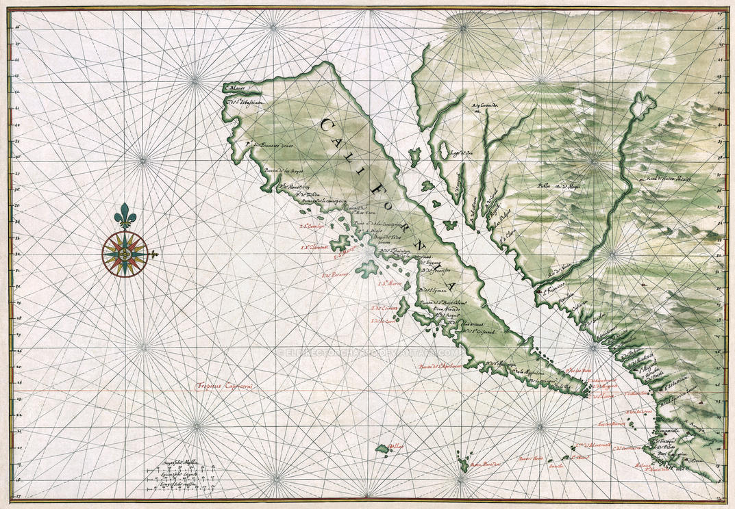
1510 – Garci Ordóñez de Montalvo first describes California as an “island very close to this side of the Terrestrial Paradise”.
1513 – Vasco Núñez de Balboa becomes the first European to sight the Pacific Ocean.
1532 – Fortún Jiménez is perhaps the first to use the name California to describe an “island” to the west of the recently conquered México.
1535 – Hernán Cortés, fresh from his conquest of México, founds a settlement on Santa Cruz Bay.
1539 – Francisco de Ulloa discovers that “California” is a peninsula, not an island. Nevertheless, the “Island of California” remains a popular image.
1540 – Hernando de Alarcón ascends the Colorado River; he becomes the first European to cross into “Alta California”.
1540 - 1542 – In search of the mythical “Seven Cities of Gold”, Francisco Vázquez de Coronado leads an expedition from the Sonora river northwards, crossing into modern-day Arizona and Colorado. [1] They become the first Europeans to sight the Grand Canyon.
1542 – Juan Rodriguéz Cabrillo commences reconnaissance of the Pacific coast of California.
1549 – Francis Drake enters San Agustín Bay [2] during his circumnavigation of the globe
1595 – The Spanish Galleon San Agustín shipwrecks at San Agustín Bay.
1602 – Sebastián Viscaíno explores California up to Cape Mendocino, in the last state-sponsored exploration of California for over 150 years.
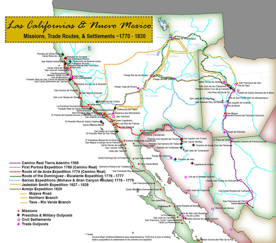
1697 – Jesuits missionaries under the command of Juan Jesus Maria de Salvatierra establish the first of eighteen missions in the California peninsula, Our Lady of Loreto. For a while, the mission system prospers as the northern flank of the Mexican frontier. The first ranchos and mining quarries in California begin to operate in support of the mission system.
1768 – Members of the Jesuit order are expelled from the Spanish Empire. To ensure the continuous operation of the California missions, they are replaced by Dominicans in Baja California and Franciscans, under the leadership of Fray Junipero Serra, in Alta California. This creates a semi-official administrative division between the provinces.
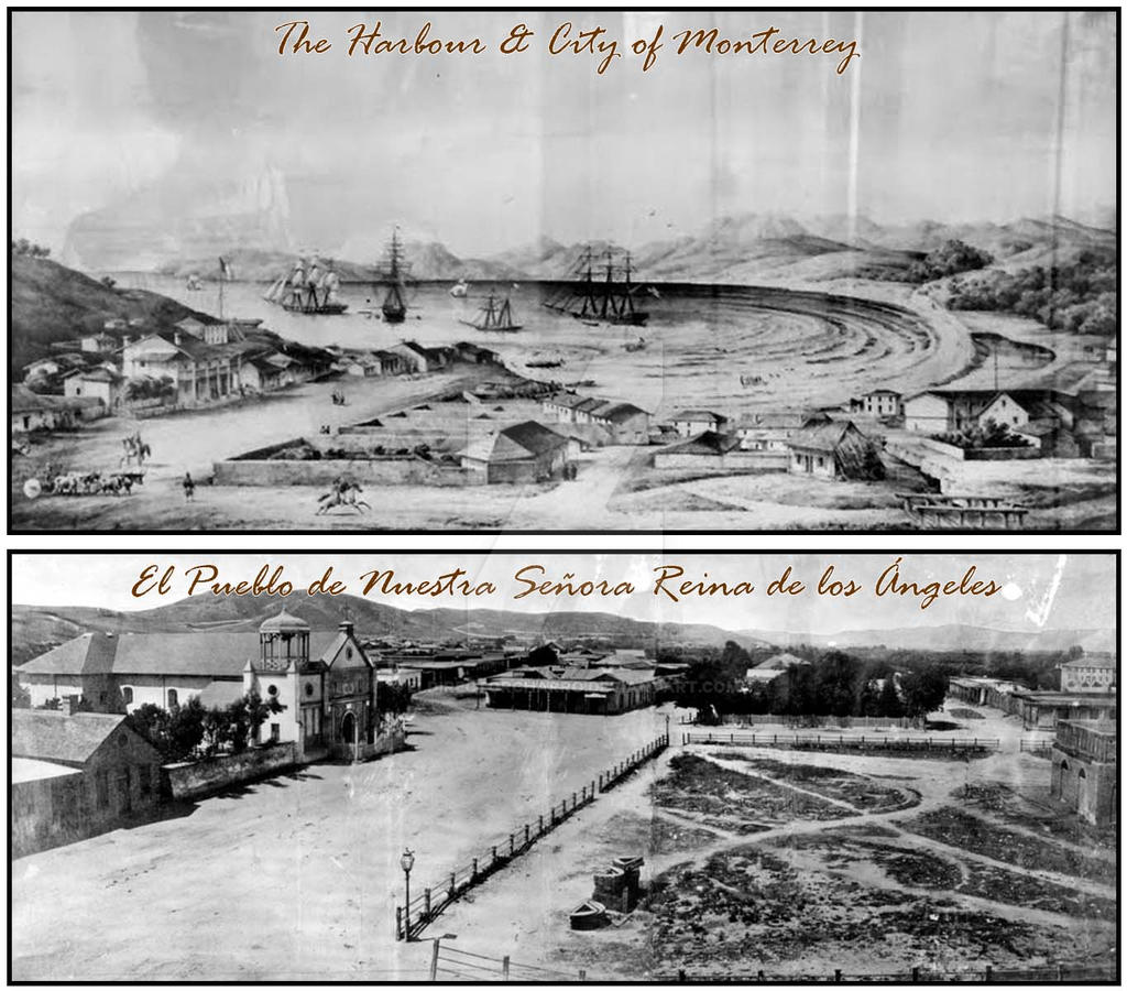
1770 – The Portolá expedition ends with the founding of the Presidio de Monterrey [3], and the Mission San Carlos Borromeo Mission in Monterrey Bay. The settlement becomes a layover stop for the Manila galleons and the primary administrative center of “both Californias”.
1774 – Captain Juan Bautista de Anza leaves Tubac, Arizona to reconnoiter a land route from Mexico to Alta California.
1775 – Spaniards discover the Golden Gate, which remained elusive due to fog and currents, and sails into San Francisco Bay
1776 – In June, the Second Anza expedition reaches the shores of San Francisco Bay; Father Francisco Palóu dedicates Mission San Francisco. The route established by de Anza would transform into El Camino Real, linking most of the settlements and missions in Alta California.
1776 – Fathers Francisco Atanasio Domínguez and Silvestre Vélez de Escalante set off from Santa Fe, to find an overland route to the California coast. The become the first Europeans to enter the Yuta Valley, sighting Lake Timpanogos and Lake Yuta [4].
1777 – the Pueblo de San José de Guadalupe is founded as the first civil settlement in Alta California.
1781 – The Pueblo de Nuestra Señora Reina de Los Ángeles is founded as the second civil settlement in Alta California.
1784 – Father Serra dies at Mission San Carlos Borromeo.
1785 – Father Pedro Estévan Tápis establishes a mission on the island of Santa Catalina, reasoning that an offshore mission might be an effective measure to restrict smuggling operations. Governor José Joaquín Arrillaga approves the plan and orders the establishment of a presidio on the northern end of the island. [5]
1786 – Jean François Galaup leads the first non-Spanish expedition into Alta California under the French flag and spends ten days anchored in Monterrey Bay.
1792 – An English naval expedition under the command of Captain George Vancouver anchors in San Francisco Bay.
1806 – the Russian ship Juno, under the command of Count Nikolai Petrovich Rezanov, arrives in San Francisco Bay.
1812 – The Russian American Fur Company establishes Krepost Ross on the coast on hundred miles north of San Francisco Bay.
1816 – The Russian naval ship Rurik, under the command of Otto von Kotzebue, arrives in San Francisco Bay. By now the Russian Empire has a semi-permanent presence in Krepost Ross and a “consulate” in Monterrey Bay.
1818 – Sailing under the flag of the "Republic of Buenos Aires", the French privateer Hippolyte Bouchard raids the Californian coast, capturing the customs house in Monterrey and holding the town for six days. A subsequent naval encounter in Santa Catalina and his capture by Jose de la Guerra y Noriega in Santa Barbara, become a symbol of regional pride for the local populace.
1821 – Father Mariano Payeras establishes the Mission San Pasqual, in the San Pasqual Valley east of San Diego with the plan to build a chain of inland missions connecting California to Sonora. [5.1]
1822 – William Edward Hartnell, better known as Don Guillermo Arnel, arrives in Monterrey and secures permits allowing British subjects to do business in Alta California. During his time he also served as tutor to prominent families in the area, with Juan Bautista Alvarado and Mariano Guadalupe Vallejo as two of his most prominent charges.
1824 – California is designated as a territory of the newly established Mexican Republic.
1824 – The French-Canadian fur trapper Étienne Provost enters the Yuta Valley. He establishes a trading post in the banks of Lake Timpanogos.
1826 – From Lake Timpanogos, trappers working for the Hudson Bay Company, under the command of Peter Skene Ogden, explore the interior of Northern California. They follow the “Old Spanish Trail” established by the Domínguez-Escalante expedition.
1826 - José María de Echeandía, the first native Mexican elected Governor of Alta California issued a "Proclamation of Emancipation". All Indians within the military districts of San Diego, Santa Barbara, and Monterrey who were made eligible to become Mexican citizens. Plans to build a twenty-fourth mission near Presidio Santa Rosa are promptly canceled. [5.2]
1827 – American trappers under the command of Jedediah Smith make the first overland penetration of California from the east and become the first white men to cross the Sierra Nevada.
1828 – Juan Bautista Valentín Alvarado y Vallejo is hired as secretary to the territorial legislature in Monterrey. Shortly after, he is appointed by Governor Echaendía to oversee the secularization of the Missión San Miguel Arcángel.
[*, **] Both quotes are derived from books by the respective authors. The timeline in this post is an adaptation of the timeline laid out in Starr’s book (about 90% of it is identical). I made some modifications to fit the TL and added elements regarding the interior (AKA Utah, and Arizona) relevant to TTL. As for the third quote, wait and see.
[1] TTL’s Arizona and Colorado, will be used as names for departments/states in TTL’s Republic of California but do not line up with OTL's states of Arizona and Colorado.
[2] Drake’s Bay in TTL. I’m not married to the name. But it seems appropriate.
[3] Spelled with “rr” in TTL as many places will keep a more accurate Spanish spelling. I'll try to make it as consistent as possible.
[4] Utah Lake and the Great Salt Lake respectively. And like in OTL it is likely, Domínguez and Escalante only saw the smaller southern lake, making Étienne Provost the first European to actually sight TTL’s Lake Yuta.
[5.0, 5.1, 5.2] The POD for TTL. The plans to build a mission in Santa Catalina Island in 1784 and the San Pasqual Valley in 1821 were not scrapped, nor was the additional presidio in Santa Rosa. I originally envisioned a later POD hinted in the third opening quote, however, I figured that the additional missions wouldn’t have drastic effects outside California.
A Timeline of the West
1510: From the Deeds of Esplandián
“Where did it come from? How did it happen? This nation-state, this commonwealth of cultures. It could be argued; never before in history had such a diverse group of people assembled so rapidly under one political system and prospered so greatly. […] What forces of war, peace, of economic shifts and social aspirations brought forth this golden island on the right hand of the Indies.” – Kevin Starr *
“The reality is that California is a complex and massive nation, and attempts to simplify it at as ‘ungovernable’, or ‘radical’ is not much accurate than calling it ‘golden’.” – Narda Zacchino **
“To think that it all began with a sordid love affair.” – Anonymous
“The reality is that California is a complex and massive nation, and attempts to simplify it at as ‘ungovernable’, or ‘radical’ is not much accurate than calling it ‘golden’.” – Narda Zacchino **
“To think that it all began with a sordid love affair.” – Anonymous
1510 – Garci Ordóñez de Montalvo first describes California as an “island very close to this side of the Terrestrial Paradise”.
1513 – Vasco Núñez de Balboa becomes the first European to sight the Pacific Ocean.
1532 – Fortún Jiménez is perhaps the first to use the name California to describe an “island” to the west of the recently conquered México.
1535 – Hernán Cortés, fresh from his conquest of México, founds a settlement on Santa Cruz Bay.
1539 – Francisco de Ulloa discovers that “California” is a peninsula, not an island. Nevertheless, the “Island of California” remains a popular image.
1540 – Hernando de Alarcón ascends the Colorado River; he becomes the first European to cross into “Alta California”.
1540 - 1542 – In search of the mythical “Seven Cities of Gold”, Francisco Vázquez de Coronado leads an expedition from the Sonora river northwards, crossing into modern-day Arizona and Colorado. [1] They become the first Europeans to sight the Grand Canyon.
1542 – Juan Rodriguéz Cabrillo commences reconnaissance of the Pacific coast of California.
1549 – Francis Drake enters San Agustín Bay [2] during his circumnavigation of the globe
1595 – The Spanish Galleon San Agustín shipwrecks at San Agustín Bay.
1602 – Sebastián Viscaíno explores California up to Cape Mendocino, in the last state-sponsored exploration of California for over 150 years.
1697 – Jesuits missionaries under the command of Juan Jesus Maria de Salvatierra establish the first of eighteen missions in the California peninsula, Our Lady of Loreto. For a while, the mission system prospers as the northern flank of the Mexican frontier. The first ranchos and mining quarries in California begin to operate in support of the mission system.
1768 – Members of the Jesuit order are expelled from the Spanish Empire. To ensure the continuous operation of the California missions, they are replaced by Dominicans in Baja California and Franciscans, under the leadership of Fray Junipero Serra, in Alta California. This creates a semi-official administrative division between the provinces.
1770 – The Portolá expedition ends with the founding of the Presidio de Monterrey [3], and the Mission San Carlos Borromeo Mission in Monterrey Bay. The settlement becomes a layover stop for the Manila galleons and the primary administrative center of “both Californias”.
1774 – Captain Juan Bautista de Anza leaves Tubac, Arizona to reconnoiter a land route from Mexico to Alta California.
1775 – Spaniards discover the Golden Gate, which remained elusive due to fog and currents, and sails into San Francisco Bay
1776 – In June, the Second Anza expedition reaches the shores of San Francisco Bay; Father Francisco Palóu dedicates Mission San Francisco. The route established by de Anza would transform into El Camino Real, linking most of the settlements and missions in Alta California.
1776 – Fathers Francisco Atanasio Domínguez and Silvestre Vélez de Escalante set off from Santa Fe, to find an overland route to the California coast. The become the first Europeans to enter the Yuta Valley, sighting Lake Timpanogos and Lake Yuta [4].
1777 – the Pueblo de San José de Guadalupe is founded as the first civil settlement in Alta California.
1781 – The Pueblo de Nuestra Señora Reina de Los Ángeles is founded as the second civil settlement in Alta California.
1784 – Father Serra dies at Mission San Carlos Borromeo.
1785 – Father Pedro Estévan Tápis establishes a mission on the island of Santa Catalina, reasoning that an offshore mission might be an effective measure to restrict smuggling operations. Governor José Joaquín Arrillaga approves the plan and orders the establishment of a presidio on the northern end of the island. [5]
1786 – Jean François Galaup leads the first non-Spanish expedition into Alta California under the French flag and spends ten days anchored in Monterrey Bay.
1792 – An English naval expedition under the command of Captain George Vancouver anchors in San Francisco Bay.
1806 – the Russian ship Juno, under the command of Count Nikolai Petrovich Rezanov, arrives in San Francisco Bay.
1812 – The Russian American Fur Company establishes Krepost Ross on the coast on hundred miles north of San Francisco Bay.
1816 – The Russian naval ship Rurik, under the command of Otto von Kotzebue, arrives in San Francisco Bay. By now the Russian Empire has a semi-permanent presence in Krepost Ross and a “consulate” in Monterrey Bay.
1818 – Sailing under the flag of the "Republic of Buenos Aires", the French privateer Hippolyte Bouchard raids the Californian coast, capturing the customs house in Monterrey and holding the town for six days. A subsequent naval encounter in Santa Catalina and his capture by Jose de la Guerra y Noriega in Santa Barbara, become a symbol of regional pride for the local populace.
1821 – Father Mariano Payeras establishes the Mission San Pasqual, in the San Pasqual Valley east of San Diego with the plan to build a chain of inland missions connecting California to Sonora. [5.1]
1822 – William Edward Hartnell, better known as Don Guillermo Arnel, arrives in Monterrey and secures permits allowing British subjects to do business in Alta California. During his time he also served as tutor to prominent families in the area, with Juan Bautista Alvarado and Mariano Guadalupe Vallejo as two of his most prominent charges.
1824 – California is designated as a territory of the newly established Mexican Republic.
1824 – The French-Canadian fur trapper Étienne Provost enters the Yuta Valley. He establishes a trading post in the banks of Lake Timpanogos.
1826 – From Lake Timpanogos, trappers working for the Hudson Bay Company, under the command of Peter Skene Ogden, explore the interior of Northern California. They follow the “Old Spanish Trail” established by the Domínguez-Escalante expedition.
1826 - José María de Echeandía, the first native Mexican elected Governor of Alta California issued a "Proclamation of Emancipation". All Indians within the military districts of San Diego, Santa Barbara, and Monterrey who were made eligible to become Mexican citizens. Plans to build a twenty-fourth mission near Presidio Santa Rosa are promptly canceled. [5.2]
1827 – American trappers under the command of Jedediah Smith make the first overland penetration of California from the east and become the first white men to cross the Sierra Nevada.
1828 – Juan Bautista Valentín Alvarado y Vallejo is hired as secretary to the territorial legislature in Monterrey. Shortly after, he is appointed by Governor Echaendía to oversee the secularization of the Missión San Miguel Arcángel.
[*, **] Both quotes are derived from books by the respective authors. The timeline in this post is an adaptation of the timeline laid out in Starr’s book (about 90% of it is identical). I made some modifications to fit the TL and added elements regarding the interior (AKA Utah, and Arizona) relevant to TTL. As for the third quote, wait and see.
[1] TTL’s Arizona and Colorado, will be used as names for departments/states in TTL’s Republic of California but do not line up with OTL's states of Arizona and Colorado.
[2] Drake’s Bay in TTL. I’m not married to the name. But it seems appropriate.
[3] Spelled with “rr” in TTL as many places will keep a more accurate Spanish spelling. I'll try to make it as consistent as possible.
[4] Utah Lake and the Great Salt Lake respectively. And like in OTL it is likely, Domínguez and Escalante only saw the smaller southern lake, making Étienne Provost the first European to actually sight TTL’s Lake Yuta.
[5.0, 5.1, 5.2] The POD for TTL. The plans to build a mission in Santa Catalina Island in 1784 and the San Pasqual Valley in 1821 were not scrapped, nor was the additional presidio in Santa Rosa. I originally envisioned a later POD hinted in the third opening quote, however, I figured that the additional missions wouldn’t have drastic effects outside California.
Last edited: