Been working on the basins again. Unfortunately, Canada only has provinces in Databasin, so that will have to wait for the time being. That being said, I'm very interested in the r-qbam project, and as much as I like the progress I've made with these maps, I'm going increasingly insane from just how inconsistent some of the qbams patches are with more reliable maps, my own work included. So I've considered discontinuing a lot of these projects and progress I've made and just wait for the more consistent map to be completed soon. We'll see
You are using an out of date browser. It may not display this or other websites correctly.
You should upgrade or use an alternative browser.
You should upgrade or use an alternative browser.
Here you go! Welcome back!
Looking at Southern China, is there a name for the region east of the Pearl and Yangtze river deltas?.
I'm not sure what you mean. Could you elaborate?Looking at Southern China, is there a name for the region east of the Pearl and Yangtze river deltas?.
I'm not sure what you mean. Could you elaborate?
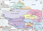
The area in the red elipse, aside from maybe the nothern most purpleish basin, cuz that area has sometimes been part of the Yangtze if I am remembering correctly.
I think it's just called Southeast Rivers BasinsView attachment 852184
The area in the red elipse, aside from maybe the nothern most purpleish basin, cuz that area has sometimes been part of the Yangtze if I am remembering correctly.

I guess if you were talking about the whole region, the only name I can think of is "Minzhe"View attachment 852184
The area in the red elipse, aside from maybe the nothern most purpleish basin, cuz that area has sometimes been part of the Yangtze if I am remembering correctly.
i.e., https://en.wikipedia.org/wiki/Minzhe
Share: