You are using an out of date browser. It may not display this or other websites correctly.
You should upgrade or use an alternative browser.
You should upgrade or use an alternative browser.
Q-Bam Historical Map Thread
- Thread starter The Alternative
- Start date
-
- Tags
- historical maps q-bam
Merry Easter!
Spring of 1206: Temujin is proclaimed Great Khan of the Mongols
You've made my day! It's been a while since I've seen a world map here. I was worried that something unfortunate had happened to you and Sharklord.
Anyhoo, what's happening in those baltic regions? They can't all be Teutonics, right?
Is that the Empire of Kitara? I have to look into that.
What is that territory north of the Mongols?
Last edited:
Crazy Boris
Banned
Merry Easter!
You've made my day! It's been a while since I've seen a world map here. I was worried that something unfortunate had happened to you and Sharklord.
Anyhoo, what's happening in those baltic regions? They can't all be Teutonics, right?
Is that the Empire of Kitara? I have to look into that.
What is that territory north of the Mongols?
In the Baltics, those are all various Balt and Finnic states. I’m not 100% sure about some of them, the line between state and tribe can get blurry here, but I think I got it. Estonians in the north, Livonians in blue below them, Latgalians in orange next to them, Semigallians to their west, Couronians on the coast, then Yotvingia next to Masovia, and the little green bit in the middle of nowhere is Lithuania in its infancy.
Yep, that’s Kitara. I mostly went off of a map on Wikipedia of sites associated with Kitara, which seems to line up with oral histories of the empire
North of the Mongols are the Yenisei Kyrgyz
What's the source on Kanem having direct control over the South and West of Lake Chad like that?.
Spring of 1206: Temujin is proclaimed Great Khan of the Mongols
Also, what are the Torqoise states in the Caucasus if the same colour.
Last edited:
Crazy Boris
Banned
For Kanem, I went off the map wikipedia had, and those are all internals for GeorgiaWhat's the source on Kanem having direct control over the South and West of Lake Chad like that?.
Also, what are the Torqoise states in the Caucasus if the same colour.
I am not an expert in the area but I read a paper about the people just south of the Chad lake (Kotoko) and it doesn't seem they were ever fully integrated into Kanem.For Kanem, I went off the map wikipedia had, and those are all internals for Georgia
It's a short read.
Kanem of this guy's simplified map for 1250 looks better.I am not an expert in the area but I read a paper about the people just south of the Chad lake (Kotoko) and it doesn't seem they were ever fully integrated into Kanem.
It's a short read.

ah shit, you beat me to it lol,
Spring of 1206: Temujin is proclaimed Great Khan of the Mongols
good work tho!
I say, still finish it
I am currently making it for something a bit different, but it's nearly doneI say, still finish it
The Dali Kingdom.What's the state between Burma and China?
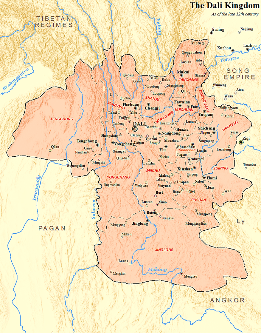
Dali Kingdom - Wikipedia
I made a gif for Genghis Khan's conquests in Asia and Europe, and I'm pretty satisfied with it so far. I want to do the rest of the Mongol Empire, perhaps up until the collapse of their states, but unfortunately I'm gonna be very busy and I'll be unable to do any of my projects I've got going unfortunately.
Let me know what you guys think, changes I should make, and tips for making gifs and whatnot
Let me know what you guys think, changes I should make, and tips for making gifs and whatnot
What are the states of Southern and Northern Nigeria?.
Spring of 1206: Temujin is proclaimed Great Khan of the Mongols
Crazy Boris
Banned
What are the states of Southern and Northern Nigeria?.
In the north are the Hausa states of Kano, Biram, Zamfara, and Zazzau, and then in the south are Akure and Owo (next to each other), Nri to their east, and then Benin on the coast.
I thought Ile-Ife was the earliest Yoruba state?In the north are the Hausa states of Kano, Biram, Zamfara, and Zazzau, and then in the south are Akure and Owo (next to each other), Nri to their east, and then Benin on the coast.
Kotoko city states in 19th Century according to this map from the Chapter "Kotoko City States by Mogens Herman Hansen" from "A Comparative Study of Thirty City-State Cultures". These are the City states in the 14th century as described by European visitors and this is the original Map.
If anyone thinks they can do the internals for Logone Birni or fix any errors they see, pls go right ahead. So Kotoko are main descendants of the Sao and according to the Paper their state formation began between 1100 and 1400 but given the Sao were pretty advanced themselves, this many be something like how the Swahili appear after an earlier City/Town state culture on the East Africa presumably ended.(Assuming towns like Rhapta were proper city/town states). Anyways, King Idris Alooma (1580 - 1617) vassalized and converted them to Islam.
It seems to line up nicely enough with this Map of Bornu Empire and its Kotoko vassals in 17th and 18th Century by another researcher so I assume its correct enough.
Last edited:
Crazy Boris
Banned
I've got a new map in progress and want some feedback. I'm trying out something new with rebels, giving them fuzzy borders by outlining the area with a 50-point opacity drop each layer. On one hand, I think it kind of illustrates rebel areas of control being-ill defined decently, but on the other hand, it kinda looks antialiased and jpegy which I think sort of gives the map a "dirty" quality.

I would prefer if that fuzzy layer is replaced with like a transition zone of one or two colours, whether dashed lines or dotted fills.I've got a new map in progress and want some feedback. I'm trying out something new with rebels, giving them fuzzy borders by outlining the area with a 50-point opacity drop each layer. On one hand, I think it kind of illustrates rebel areas of control being-ill defined decently, but on the other hand, it kinda looks antialiased and jpegy which I think sort of gives the map a "dirty" quality.
It looks like it could be ok but I'd like to see it in the context of the larger mapI've got a new map in progress and want some feedback. I'm trying out something new with rebels, giving them fuzzy borders by outlining the area with a 50-point opacity drop each layer. On one hand, I think it kind of illustrates rebel areas of control being-ill defined decently, but on the other hand, it kinda looks antialiased and jpegy which I think sort of gives the map a "dirty" quality.
Share: