I would love to do it, but sadly, college has me with very few free time, and it would take me quite long to finish it. Hopefully someone else will be able toAh I don't have this experience. Could you convert the 1863 map to a 4k or 2k bam or whatever is equivalent and I can work from there? I don't know how to do it myself, how do I know what pixel goes where? Once you give me a base map to work on I can work it out from there by comparing
You are using an out of date browser. It may not display this or other websites correctly.
You should upgrade or use an alternative browser.
You should upgrade or use an alternative browser.
Q-Bam Historical Map Thread
- Thread starter The Alternative
- Start date
-
- Tags
- historical maps q-bam
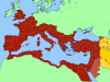
Decided to make a map of the Roman Empire in 395 at the death of Theodosius I. I decided not to do the East-West Split between the Empires just because there's not a border with the qbam main color scheme with personal unions/non-combatant/autonomous forces that I usually use.
Attachments
am i crazy or was there a cyprus city states map here done in THICC colours? saw a video on ancient cyprus today and remembered such a thing. maybe it was borderpool or something but i could swear it was a historical q-bam map
Crazy Boris
Banned
I decided not to do the East-West Split between the Empires just because there's not a border with the qbam main color scheme with personal unions/non-combatant/autonomous forces that I usually use.
After Theodosius dies, East and West and generally considered separate countries, so they should be given different colors
Crazy Boris
Banned
I made an armistice day map 2 years ago.
It wasn't very good so I made a better one.

Edit: some minor fixes
It wasn't very good so I made a better one.
Edit: some minor fixes
Last edited:
British in Conakry? The peninsula off of french guinea, I wasn't aware they ever had control. EDIT: just cause the Los islands off there were a British possession until 1904, so I'm kinda confused?I made an armistice day map 2 years ago.
It wasn't very good so I made a better one.
Edit: some minor fixes
Last edited:
Crazy Boris
Banned
British in Conakry? The peninsula off of french guinea, I wasn't aware they ever had control. EDIT: just cause the Los islands off there were a British possession until 1904, so I'm kinda confused?
Yeah, thats supposed to be the Los Islands

I made an armistice day map 2 years ago.
It wasn't very good so I made a better one.
ALL your maps are good.
I, for one, really appreciate them.
Yeah, thats supposed to be the Los Islands
But if this is Armstice Day (November 1918) wouldn't the islands already be French? After all they were ceded to France in 1904 no?
Crazy Boris
Banned
But if this is Armstice Day (November 1918) wouldn't the islands already be French? After all they were ceded to France in 1904 no?
Oh... crap.... this is embarrassing....
View attachment 584543Belgian Congo and subdivs in 1925 if anyone wants it
Crazy Boris
Banned
View attachment 584543Belgian Congo and subdivs in 1925 if anyone wants it
More patches for Africa are always appreciated
Did several patches for Rome, the provinces, and some of the borders with the Parthians in 117.
Hello. Does anyone have a QBAM patch for the FRCA/UPCA (Central America) in 1830-ish?
what source did you use for the borders/View attachment 584899most of southern Africa in 1925
I used the hisatlas map for 1925 africa. I had a compilation of other sources but I couldn't find any that didn't conflict.what source did you use for the borders/
Share: