Crazy Boris
Banned
Wondering if anyone has Prussia's borders after the Third Partition of Poland and before the Treaty of Tilsit? The maps in the compilation skip straight from 1789 to 1812.
Wondering if anyone has Prussia's borders after the Third Partition of Poland and before the Treaty of Tilsit? The maps in the compilation skip straight from 1789 to 1812.
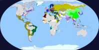
Is that a reef of the Brazilian coast?I had my go at a map of the world in 1756 AD.
I'm not sure how much control the Iroquois had over all that territory.I'm working on a full 1756 (just before the 7 years war), this is a WIP North America:
View attachment 660770
I'm trying to map the most important native groups, or the ones that had contact with Europeans, or lived in "European Territory" (colonial claims). Some borders are really imprecise, so they might be wrong.
Their original territory was only northern Pennsylvania and New York, yeah. However, in the XVII and XVIII centuries they had some expansion, and they, by 1756, expanded (not only conquering other tribes, but also "adding" them to the confederation) up until the territory shown there.I'm not sure how much control the Iroquois had over all that territory.
A few native american tribes you should definitely add are the Shawnee, Miami, Lenape Delaware, Odawa, Wabanaki Confederacy, and Illini Confederacy, as each should be somewhat independent around this time and were very important in the wars to come pre and post revolution.I'm working on a full 1756 (just before the 7 years war), this is a WIP North America:
View attachment 660770
I'm trying to map the most important native groups, or the ones that had contact with Europeans, or lived in "European Territory" (colonial claims). Some borders are really imprecise, so they might be wrong.
California is getting me a headache.
Coolness, except for one thing...Another preview (1756 North America):
View attachment 662378
Edit:
Here's Europe, I still have to fix some things but it's nearly finished.
View attachment 662413
Only in the way that the really tiny states are too small to be shown on the map.1756 HRE isn't *that* complicated. I think you could pull it off.

Just some noticeable things wrong hereEdit:
Here's Europe, I still have to fix some things but it's nearly finished.
View attachment 662413
I mean obviously the "really tiny" states aren't going to be shown, but in this case, the map maker is just outright lazy. There are numerous states that can be shown like Wurttemberg, the Palteinate holdings along the Rhine, Nassau, Hessen-Darmstadt, Hessen-Kassel, Trier, Cologne, Munster, Westfalia, Paderborn, Mainz, Wurzburg, Bamberg, Ansbach, Bayreuth, and much much more. All of which are much larger than the likes of San Marino, Monaco or Liechtenstein. Instead, we have the giant Germany blob and the couple of "outliers" like Passau because it's convenient to fill-bucket.Only in the way that the really tiny states are too small to be shown on the map.
Some of them have been fixed prior to this, as I've been working on in and improving some stuff, thank you for your corrections and suggestions.Just some noticeable things wrong here
As said previously, the HRE shown in that map is really incomplete as I still had to work on it. As Europe is basically completed except for the HRE, I just wanted to show the progress.I mean obviously the "really tiny" states aren't going to be shown, but in this case, the map maker is just outright lazy. There are numerous states that can be shown like Wurttemberg, the Palteinate holdings along the Rhine, Nassau, Hessen-Darmstadt, Hessen-Kassel, Trier, Cologne, Munster, Westfalia, Paderborn, Mainz, Wurzburg, Bamberg, Ansbach, Bayreuth, and much much more. All of which are much larger than the likes of San Marino, Monaco or Liechtenstein. Instead, we have the giant Germany blob and the couple of "outliers" like Passau because it's convenient to fill-bucket.