Q-Bam Historical Map Thread

1770lebals.png

1770 map with labels
unknown.png

And without

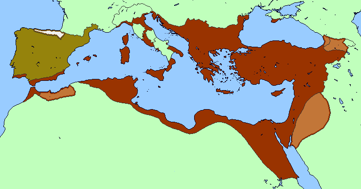
I could do the 9 AD one too sometime later

Excellent maps, but I have a minor nitpick: here in 1770 Nepal is displayed as a bunch of random statelets jammed in, but Nepal was pretty much all subjugated under Prithvi Narayan Shah and his new Kingdom of Nepal - founded two years prior to the map, so perhaps it should be one unified Kingdom instead of all the districts you list in the color key.
 
This is a map of Roman expansion that I posted quite a while ago in the OTL map thread. I didn't post it here because it wasn't in the QBAM style with borders and colors.

rome expansion flat-albania.png


So now I've finished a series of patches that shows the expansion of Rome. A few caveats:
  • This is a work in progress; I'd like to later add client states and provinces. For now, it shows directly annexed territory only.
  • On the other hand, Italy before 88 BC was in fact a patchwork of annexed territory and client cities and tribes. I've followed convention in showing the patchwork as all Roman territory. Showing all the client socii could be an interesting project, but not easy at this scale. And I'm not confident that accurate maps of Italy are even available for every date.
  • On the original, the Bosporan Kingdom (Crimea) was the only client state that I showed; this is because it was the only client never to be annexed during this period. I chose to show it because it was definitely part of the Roman world, so omitting it seemed misleading. The date given corresponds to the establishment of permanent Roman garrisons in the kingdom. On the following QBAM patches, I show those garrisons rather than the entire kingdom.
  • I confess that I don't follow this thread closely. So while I searched a little to make sure I wasn't duplicating somebody else's work, it's still totally possible that someone else already did this and did a better job of it.
With that in mind, here are the maps.

qbam rome patch 1.png


qbam rome patch 2.png


qbam rome patch 3.png

qbam rome patch 4.png

qbam rome patch 5.png
 
Last edited:

Crazy Boris

Banned
Excellent maps, but I have a minor nitpick: here in 1770 Nepal is displayed as a bunch of random statelets jammed in, but Nepal was pretty much all subjugated under Prithvi Narayan Shah and his new Kingdom of Nepal - founded two years prior to the map, so perhaps it should be one unified Kingdom instead of all the districts you list in the color key.

I think that the unification of Nepal started around this time, but it took a while before the Gorkhas took over all the small kingdoms
 
I think that the unification of Nepal started around this time, but it took a while before the Gorkhas took over all the small kingdoms

I was initially confused myself considering the dates on other articles like “the Expansion is the Gorkha Kingdom” use different dates just ahead of what I found on Prithvi Narayan’s page, but upon closer inspection, the Gorkha Expansion article uses the dates in the Vikrami Calendar which renders everything a few decades ahead of the Gregorian calendar - which causes significant confusion. The Battle of Kathmandu - which signified the final Gorkha victory over the Nepalese - was fought in 1768 CE though. After the battle:

“In the following months, the Gorkhalis also conquered Lalitpur. The three kings of Nepal then gathered in Bhaktapur for a final stand against the aggressors. Shah conquered Bhaktapur in 1769, thus completing his conquest of Nepal. He established the Shah dynasty which remained until 2008 when Nepal became a republic.”

This means the polities should be unified on a map depicting 1770 CE.
 
As awesome as these maps are, I find the lack of HRE states distur...um, somewhat annoying.

Can someone make some patches just for the HRE?

I’ve wanted to do some for some time but I’m having a hell of a time finding proper sourcing for the Medieval HRE - maybe they get easier to come by post-1648, I’ll check it out.
 

Crazy Boris

Banned
Managed to get the 9 AD map done nice and quick, way easier than 1770 was since there's like 30-40 times fewer countries

unknown.png

Blank map

unknown.png

And with labels
 
Managed to get the 9 AD map done nice and quick, way easier than 1770 was since there's like 30-40 times fewer countries

unknown.png

Blank map

unknown.png

And with labels
Probably the most minor imaginable nitpick, but I think the Han controlled Gaochun/Guisui/Hohhot and the Ordos region at this point?
 
Managed to get the 9 AD map done nice and quick, way easier than 1770 was since there's like 30-40 times fewer countries

One thing I notice, is that Palestine contained several client states of Rome at this time, namely three of the four kingdoms of the Herodian Tetrarchy plus the city-states of the Decapolis. Only central Judea had been annexed. This is a rather quick attempt at a patch to show that.

QBAM palestine 9.png
 
@Crazy Boris Wow, first of all, these are amazing. Awesome work. Could you point me in the direction of your sources for pre-colonial Africa? I've been struggling to find good ones for use in working on my NextGen series. It's one of the few regions I don't have good source material to draw from at this point.
 

Crazy Boris

Banned
@Crazy Boris Wow, first of all, these are amazing. Awesome work. Could you point me in the direction of your sources for pre-colonial Africa? I've been struggling to find good ones for use in working on my NextGen series. It's one of the few regions I don't have good source material to draw from at this point.

There's this map on Wiki from the "Scramble for Africa" article (very conveniently in QBAM) https://upload.wikimedia.org/wikipedia/commons/a/a8/Scramble-for-Africa-1880-1913.png

Other sources are Worldstatesmen, Historyfiles, and assorted videomaps on Youtube (Ollie Bye, EmperorTigerstar, Jake Mapping, Drex, and my own work for Liberia and South Africa)
 
This is a map of Roman expansion that I posted quite a while ago in the OTL map thread. I didn't post it here because it wasn't in the QBAM style with borders and colors.

View attachment 470591

So now I've finished a series of patches that shows the expansion of Rome. A few caveats:
  • This is a work in progress; I'd like to later add client states and provinces. For now, it shows directly annexed territory only.
  • On the other hand, Italy before 88 BC was in fact a patchwork of annexed territory and client cities and tribes. I've followed convention in showing the patchwork as all Roman territory. Showing all the client socii could be an interesting project, but not easy at this scale. And I'm not confident that accurate maps of Italy are even available for every date.
  • On the original, the Bosporan Kingdom (Crimea) was the only client state that I showed; this is because it was the only client never to be annexed during this period. I chose to show it because it was definitely part of the Roman world, so omitting it seemed misleading. The date given corresponds to the establishment of permanent Roman garrisons in the kingdom. On the following QBAM patches, I show those garrisons rather than the entire kingdom.
  • I confess that I don't follow this thread closely. So while I searched a little to make sure I wasn't duplicating somebody else's work, it's still totally possible that someone else already did this and did a better job of it.
With that in mind, here are the maps.

View attachment 470580

View attachment 470581

View attachment 470582
View attachment 470583
View attachment 470584
That map is for the middle ages, however I'd love to whip one up for the first century.

As to the Low Countries, I have only for the 9th century and 10th/11tg.
 
Last edited:
ddbzjpx-eab35ce4-e228-44a8-8ae8-aff10cb49d21.png


c. 600 CE WIP, posting it now because I'm just making it as a springboard for a ATL idea and I won't be adding much(if anything) beyond this before I break from OTL. Anyone can feel free to continue this, I'm fairly confident about the borders apart from the Caucasus.
I can help you with those, i have some somewhere in storage. Love to share them. Various sources, mostly from Wikipedia, Euratlas, and Ian Mladjov.
 
Crazy Boris

Can I just point out how that's not how Sweden's border with Russia looked like in 1770.
Ever since the Russo-Swedish war of 1741-1743 the border looked like this: (the Green part was lost in 1743 if you couldn't tell)

1700-talet_2.gif
1743.gif


What's even worse is that this is a mistake I keep seeing despite not being accurate.
I don't know where people got the idea that this isn't what sweden's border post-1743 looked like.

I just wanted to point it out as your map correctly does not feature the modern Russo-Norwegian border (another common mistake I've seen a lot)
 
Top