That's...ambitious.I don't know, but on the other hand I did find two more maps of "Cossackia", one from 1936 and the second from 1945:
View attachment 819350
You are using an out of date browser. It may not display this or other websites correctly.
You should upgrade or use an alternative browser.
You should upgrade or use an alternative browser.
Proposals and War Aims That Didn't Happen Map Thread
- Thread starter Beedok
- Start date
I am looking to make a map project containing all man-made macro-engineering proposals that can be seen from a world map/space, so please recommend me proposals that are not on this small list!
The criteria I came up with, is that they must be proposals that have been made in real life with serious intent, no jokes, however for the sake of convenience, I would be willing to hear your own proposals for such macro-engineering projects that can change the world map, but I am unlikely to put them on a map, I strictly want to hear ones that actually came from real life.

This WorldA shows the following:
Atlantropa & New African Lakes & Suez Canal Extension (Mediterranean Sea & Central Africa, 1920s-1960s; the most famous one, and no, Atlantropa was not a Nazi plan)

 en.wikipedia.org
Qattara Depression Project (Egypt, 1927-1970s)
en.wikipedia.org
Qattara Depression Project (Egypt, 1927-1970s)
 en.wikipedia.org
Red Sea Dam (Middle East & East Africa, 2007)
en.wikipedia.org
Red Sea Dam (Middle East & East Africa, 2007)
 en.wikipedia.org
Northern River Reversal (Siberia & Central Asia, 1930s-1986)
en.wikipedia.org
Northern River Reversal (Siberia & Central Asia, 1930s-1986)
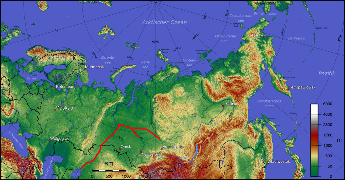 en.wikipedia.org
Rampart Dam (Alaska, 1954-1985)
en.wikipedia.org
Rampart Dam (Alaska, 1954-1985)
 en.wikipedia.org
Not shown on the map yet, looking for assistance, you can make your own since I suck at it:
Sahara sea (North Africa, 1880s-present)
 en.wikipedia.org
Northern European Enclosure Dam & the Doggerland Project (Western Europe, 1930s-present)
en.wikipedia.org
Northern European Enclosure Dam & the Doggerland Project (Western Europe, 1930s-present)
en.wikipedia.org
Disclaimers and credits:
I did NOT made the Siberian lake on the WorldA, nor the Chad & Congo Basins, the Siberian lake was made by @Mr. Bubbles on page 164 of this thread, and the Central African Basins were made by Zauberfloete on DeviantArt - all credits go to its creators, not me!
Edit 1: Fixed wrong colors and added the Rampart Dam originally made by KitFisto1997 on DeviantArt.
The criteria I came up with, is that they must be proposals that have been made in real life with serious intent, no jokes, however for the sake of convenience, I would be willing to hear your own proposals for such macro-engineering projects that can change the world map, but I am unlikely to put them on a map, I strictly want to hear ones that actually came from real life.
This WorldA shows the following:
Atlantropa & New African Lakes & Suez Canal Extension (Mediterranean Sea & Central Africa, 1920s-1960s; the most famous one, and no, Atlantropa was not a Nazi plan)
Atlantropa - Wikipedia
Qattara Depression Project - Wikipedia
Red Sea Dam - Wikipedia
Northern river reversal - Wikipedia
Rampart Dam - Wikipedia
Not shown on the map yet, looking for assistance, you can make your own since I suck at it:
Sahara sea (North Africa, 1880s-present)
Sahara Sea - Wikipedia
Northern European Enclosure Dam - Wikipedia
Disclaimers and credits:
I did NOT made the Siberian lake on the WorldA, nor the Chad & Congo Basins, the Siberian lake was made by @Mr. Bubbles on page 164 of this thread, and the Central African Basins were made by Zauberfloete on DeviantArt - all credits go to its creators, not me!
Edit 1: Fixed wrong colors and added the Rampart Dam originally made by KitFisto1997 on DeviantArt.
Last edited:
I am looking to make a map project containing all man-made macro-engineering proposals that can be seen from a world map/space, so please recommend me proposals that are not on this small list!
The criteria I came up with, is that they must be proposals that have been made in real life with serious intent, no jokes, however for the sake of convenience, I would be willing to hear your own proposals for such macro-engineering projects that can change the world map, but I am unlikely to put them on a map, I strictly want to hear ones that actually came from real life.
View attachment 819367
This WorldA shows the following:
Atlantropa (Mediterranean Sea, 1920s-1960s; the most famous one, and no, this was not a Nazi plan)
Atlantropa - Wikipedia
Qattara Depression Project (Egypt, 1927-1970s)
Qattara Depression Project - Wikipedia
Red Sea Dam (Middle East & East Africa, 2007)
Red Sea Dam - Wikipedia
Northern River Reversal (Siberia & Central Asia, 1930s-1986)
Northern river reversal - Wikipedia
Not made yet, looking for assistance: Sahara sea (1880s-present)
Sahara Sea - Wikipedia
Northern European Enclosure Dam - Wikipedia
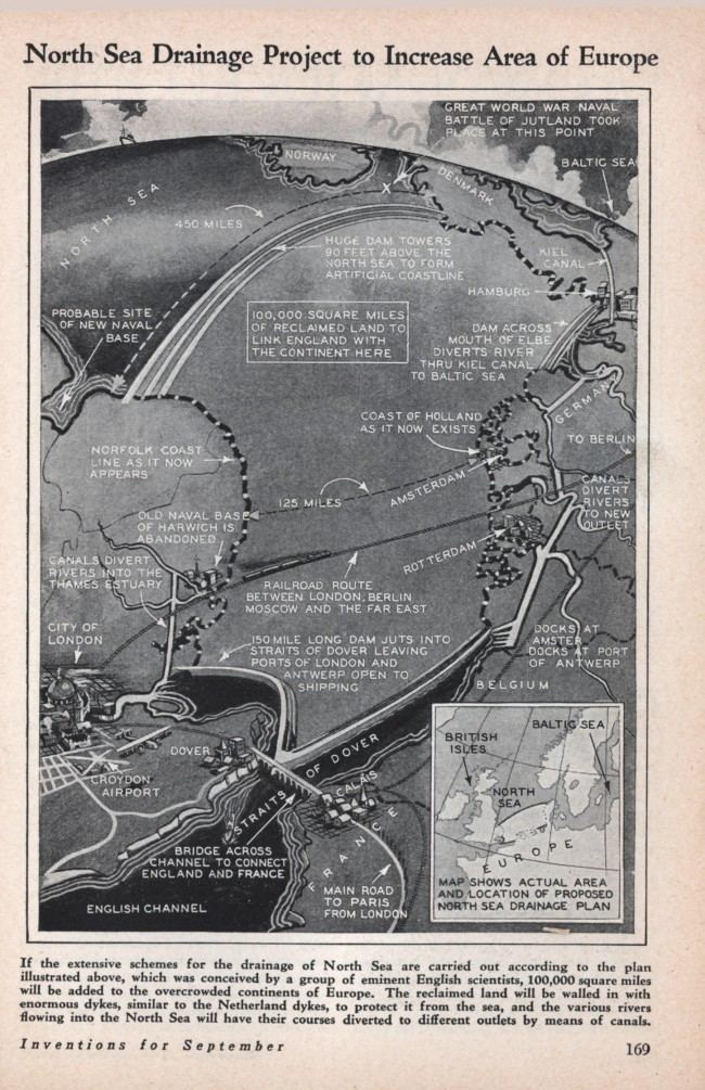
1930: The Plan To Drain And Dam The North Sea And Create DOGGERLAND - Flashbak
Walking from Harwich to Amsterdam...
 flashbak.com
The Rampart Dam in Alaska would have created a reservoir the size of lake ErieI am looking to make a map project containing all man-made macro-engineering proposals that can be seen from a world map/space, so please recommend me proposals that are not on this small list!
The criteria I came up with, is that they must be proposals that have been made in real life with serious intent, no jokes, however for the sake of convenience, I would be willing to hear your own proposals for such macro-engineering projects that can change the world map, but I am unlikely to put them on a map, I strictly want to hear ones that actually came from real life.
View attachment 819367
This WorldA shows the following:
Atlantropa (Mediterranean Sea, 1920s-1960s; the most famous one, and no, this was not a Nazi plan)
Qattara Depression Project (Egypt, 1927-1970s)Atlantropa - Wikipedia
Red Sea Dam (Middle East & East Africa, 2007)Qattara Depression Project - Wikipedia
Northern River Reversal (Siberia & Central Asia, 1930s-1986)Red Sea Dam - Wikipedia
(Disclaimer: I did NOT made the Siberian lake on the WorldA, it was made by @Mr. Bubbles on page 164 of this thread, all credits go to this user, not me!)Northern river reversal - Wikipedia
Not made yet, looking for assistance: Sahara sea (1880s-present)
Sahara Sea - Wikipedia
Attachments
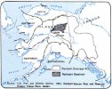
The Rampart Dam in Alaska would have created a reservoir the size of lake Erie
SHIT I am so sorry! I deleted my post because I forgot to put on the Chad lake and Congo lake basins and I am working on them right now! @CalBearNorthern European Enclosure Dam - Wikipedia
1930: The Plan To Drain And Dam The North Sea And Create DOGGERLAND - Flashbak
Walking from Harwich to Amsterdam...
@Burton K Wheeler is there a way to undelete my post? but I will update the map as soon as the post is undeleted.
Edit: I have finished them, but this Alaska dam looks difficult to make it on WorldA given its projection, I will wait for CalBear to undelete my comment, I had no idea people would reply to it so quickly.
Last edited:
post restored.SHIT I am so sorry! I deleted my post because I forgot to put on the Chad lake and Congo lake basins and I am working on them right now! @CalBear
@Burton K Wheeler is there a way to undelete my post? but I will update the map as soon as the post is undeleted.
Edit: I have finished them, but this Alaska dam looks difficult to make it on WorldA given its projection, I will wait for CalBear to undelete my comment, I had no idea people would reply to it so quickly.
Yeah, I immediately thought, “Wait, the New Madrid Earthquake did THAT much damage?” and got very confused.Calling the river diversions of the second hundred millennia BCE "historic" is quite a stretch.
Cheers, I have also updated the post to include the Congo and Chad lake basins, I am sorry for the inconvenience.post restored.
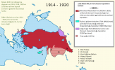
This map is generally correct, Turkish army in syrian and iraq fronts had completely collapsed and in full retreat so situation was very fluid, a Turkish-Azerbaijani army under Turkish command was also occupying Azerbaijan, some of Northern Iran and most of Dagestan disquised as Islamic Army of the Caucasus, because of the Brest-Litovsk treaty Turkish army couldn't legally be there. Red and white/red striped parts are the line on the day of the armistice, the other colours show turkish claims after the war, Turkish position was keeping everything they controlled on the day of the armistice, islands they had temporarily given to other countries, the lands they got from russia with the brest-litovsk treaty and bulgarian thrace which had a turkish majorityIs there any good map of the Armistice of Moudros borders floating around?
Attachments
Last edited:
Thank you. I was hoping to see fleshed out though what exactly the Ottomans held in modern-day Syria. In that regard, the map seems vague.This map is generally correct, Turkish army in syrian and iraq fronts had completely collapsed and in full retreat so situation was very fluid, a Turkish-Azerbaijani army under Turkish command was also occupying Azerbaijan, some of Northern Iran and most of Dagestan disquised as Islamic Army of the Caucasus, because of the Brest-Litovsk treaty Turkish army couldn't legally be there. Red and white/red striped parts are the line on the day of the armistice, the other colours show turkish claims after the war, Turkish position was keeping everything they controlled on the day of the armistice, islands they had temporarily given to other countries, the lands they got from russia with the brest-litovsk treaty and bulgarian thrace which had a turkish majority
Colorado was also super unpopulated, plus its not like it can't just remain as a territory for a while. When I calculated the respective populations (back when I was operating under the assumption that the borders followed county borders), Shasta had ~6,000 people in 1850, and ~50,000 people in 1860, while Colorado had ~12,000 people in 1850, and ~48,000 people in 1860. (this smaller) California went from ~230,000 people to ~620,000 people.Any Shasta state would be too underpopulated IMO, should just be annexed to California (and that way California and Colorado would be of comparable size).
Last edited:
Sacer Bubonicus
Banned
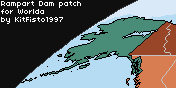
KitFisto1997 did a Rampart Dam patch on DA.Not shown on the map yet, looking for assistance, you can make your own since I suck at it:
Rampart Dam (Alaska, 1954-1985)
Rampart Dam - Wikipedia
Last edited:
I will try to get something more detailed soon, British and Arap forces drove straight from Damascus to Aleppo very fast and they were stopped just outside Aleppo, in rest of Syria it was a gradual unorganized withdrawl as troops didnt want to be left behind, usually british and arab forces entered towns just after the turkish troops leftThank you. I was hoping to see fleshed out though what exactly the Ottomans held in modern-day Syria. In that regard, the map seems vague.
These maps are from Turkish General Staff's book, i hope its useful, as you will see there isn't always contact between Turkish and British positions as the Turkish army was trying to retreat faster than the British to establish a defensible line. Last map shows the areas under Turkish army control after the Mondoros Armistice as they had to retreat from Cilicia and Musul Province according to the clauses in the treatyThank you. I was hoping to see fleshed out though what exactly the Ottomans held in modern-day Syria. In that regard, the map seems vague.
The Rampart Canyon dam is just the beginning. Just the rest of the Yukon main stream dams (Woodchopper upstream, and some combination of Ruby, Kaltag and Holy Cross downstream) would amount to about as much reservoir surface area as Rampart Canyon. As well as that, you've got the dams on the Yukon's tributaries, the Crooked Creek dam on the Kuskokwim, Copper Canyon down by Valdez, and the Yukon-Taiya scheme. The latter would reduce output of the Yukon main stream dams, but produce power closer to markets.The Rampart Dam in Alaska would have created a reservoir the size of lake Erie
If you want to go really overboard, there's NAWAPA, which wanted to turn the entire Rocky Mountain Trench into a reservoir, and the competing GRAND project to dam James Bay and raise the level of the Great Lakes.
In Australia, you've got the Bradfield scheme to divert rivers westwards and fill Lake Eyre, which almost certainly wouldn't work but that never stopped anyone from having a grand plan.
Worlda patches for both of these, if possible, would be great. Gotta love these geography changing projects.If you want to go really overboard, there's NAWAPA, which wanted to turn the entire Rocky Mountain Trench into a reservoir, and the competing GRAND project to dam James Bay and raise the level of the Great Lakes.
In Australia, you've got the Bradfield scheme to divert rivers westwards and fill Lake Eyre, which almost certainly wouldn't work but that never stopped anyone from having a grand plan.
I meant moreso in the long term, though of course that's impossible for anyone to predict at the time of admission.Colorado was also super unpopulated, plus its not like it can't just remain as a territory for a while. When I calculated the respective populations (back when I was operating under the assumption that the borders followed county borders), Shasta had ~6,000 people in 1850, and ~50,000 people in 1860, while Colorado had ~12,000 people in 1850, and ~48,000 people in 1860. (this smaller) California went from ~230,000 people to ~620,000 people.
I do know there's something Qbam patches for Atlantropa and the African Sea proposals, but I've never seen one for
Also, I've seen the African Seas and Atlantropa in patches for QBAM, but I've never seen anyone do that for the Northern River Reversal. If anyone wants to get on that, I would be so thankful.
Great work!I am looking to make a map project containing all man-made macro-engineering proposals that can be seen from a world map/space, so please recommend me proposals that are not on this small list!
The criteria I came up with, is that they must be proposals that have been made in real life with serious intent, no jokes, however for the sake of convenience, I would be willing to hear your own proposals for such macro-engineering projects that can change the world map, but I am unlikely to put them on a map, I strictly want to hear ones that actually came from real life.
View attachment 819557
This WorldA shows the following:
Atlantropa & New African Lakes (Mediterranean Sea & Central Africa, 1920s-1960s; the most famous one, and no, Atlantropa was not a Nazi plan)
Qattara Depression Project (Egypt, 1927-1970s)Atlantropa - Wikipedia
Red Sea Dam (Middle East & East Africa, 2007)Qattara Depression Project - Wikipedia
Northern River Reversal (Siberia & Central Asia, 1930s-1986)Red Sea Dam - Wikipedia
Rampart Dam (Alaska, 1954-1985)Northern river reversal - Wikipedia
Rampart Dam - Wikipedia
Not shown on the map yet, looking for assistance, you can make your own since I suck at it:
Sahara sea (North Africa, 1880s-present)
Northern European Enclosure Dam & the Doggerland Project (Western Europe, 1930s-present)Sahara Sea - Wikipedia
Northern European Enclosure Dam - Wikipedia
Disclaimers and credits:
I did NOT made the Siberian lake on the WorldA, nor the Chad & Congo Basins, the Siberian lake was made by @Mr. Bubbles on page 164 of this thread, and the Central African Basins were made by Zauberfloete on DeviantArt - all credits go to its creators, not me!
Edit 1: Fixed wrong colors and added the Rampart Dam originally made by KitFisto1997 on DeviantArt.
Also, I've seen the African Seas and Atlantropa in patches for QBAM, but I've never seen anyone do that for the Northern River Reversal. If anyone wants to get on that, I would be so thankful.
Thanks a lot, so glad to hear critiques on my works! also I often see some Atlantropa WorldA maps on the internet with a "Kalahari Lake" on Botswana and Namibia, but was this an actual plan that was considered by Herman Sörgel, or anyone else? as far as I remember he only specifically mentioned filling the Chad and Congo basins.I do know there's something Qbam patches for Atlantropa and the African Sea proposals, but I've never seen one for
Great work!
Also, I've seen the African Seas and Atlantropa in patches for QBAM, but I've never seen anyone do that for the Northern River Reversal. If anyone wants to get on that, I would be so thankful.
It was Ernest Schwarz that proposed the flooding of the Kalahari in 1919. Some good sources on this:Thanks a lot, so glad to hear critiques on my works! also I often see some Atlantropa WorldA maps on the internet with a "Kalahari Lake" on Botswana and Namibia, but was this an actual plan that was considered by Herman Sörgel, or anyone else? as far as I remember he only specifically mentioned filling the Chad and Congo basins.
An Empire of Rivers: The Scheme to Flood the Kalahari, 1919–1945
The Kalahari and Its Possibilities, written by Schwarz himself
The Kalahari Scheme as the solution of the South African drought problem, also written by Schwarz
Share: