They're still pretty close to that in some places.The Balkans were basically a Jackson Pollock painting of ethnicity at the time.
You are using an out of date browser. It may not display this or other websites correctly.
You should upgrade or use an alternative browser.
You should upgrade or use an alternative browser.
Proposals and War Aims That Didn't Happen Map Thread
- Thread starter Beedok
- Start date
From wiki:I actually don't know what the frontiers would have been, so could I get a description of them?
- Russia would return a portion of Xinjiang to China, keeping the western Ili Valley and the Tekes River – ensuring that Russia would have access to the southern portion of Xinjiang
- In the lands that were being returned, Russia would retain any property rights it had established during the occupation
- Any of the Dungan people who rebelled could choose to become Russian citizens, and those who did not would not be punished for their activities during the rebellion
- Russia was given the right to open seven new consulates in Xinjiang and Mongolia
- Russia could engage in trade without duties in Xinjiang and Mongolia
- Russian merchants were given access to trade routes extending as far as Beijing and Hankou on the Yangtze
- China would pay an indemnity of five million rubles to cover Russia's occupation costs and property losses
I thought these were the terms of the treaty that was actually signed.From wiki:
- Russia would return a portion of Xinjiang to China, keeping the western Ili Valley and the Tekes River – ensuring that Russia would have access to the southern portion of Xinjiang
- In the lands that were being returned, Russia would retain any property rights it had established during the occupation
- Any of the Dungan people who rebelled could choose to become Russian citizens, and those who did not would not be punished for their activities during the rebellion
- Russia was given the right to open seven new consulates in Xinjiang and Mongolia
- Russia could engage in trade without duties in Xinjiang and Mongolia
- Russian merchants were given access to trade routes extending as far as Beijing and Hankou on the Yangtze
- China would pay an indemnity of five million rubles to cover Russia's occupation costs and property losses
They were, but I'm looking for what was proposed prior to the treaty.I thought these were the terms of the treaty that was actually signed.
Btw do we have something similar concering Charles XII goals in 1700 northern war?The Treaty of Radnot, signed on December 6, 1656, was meant to formally partition Poland-Lithuania after the Second Northern War. According to the treaty:
View attachment 608217
- Sweden was to receive Royal Prussia, Kujawy, northern Masovia, Samogitia, Courland and Inflanty.
- Bogusław Radziwiłł was to receive the Nowogrodek Voivodeship.
- Brandenburg to receive Greater Poland.
- The Cossack Hetmanate would receive a large portion of south-east Poland.
- The rest would be given to the prince of Transylvania.
In addition, Bogusław Radziwiłł's claims at the treaty:
View attachment 608218
Now, the fate of Lithuania Proper was uncertain, and from what I can infer, was to be possibly a Swedish vassal or completely independent.
View attachment 608219
(aside of Lesczynski as king of Poland, Holstein-Gottorp and Mazepas Ukraine, what were Sweden aims? Anything else, beside (possibly) these and, most importantly, survival?
 )
)Yeah, sometimes the line between "military genius" and "lunatic" is a rather fine one...Btw do we have something similar concering Charles XII goals in 1700 northern war?
(aside of Lesczynski as king of Poland, Holstein-Gottorp and Mazepas Ukraine, what were Sweden aims? Anything else, beside (possibly) these and, most importantly, survival?
Not that I know of territorially, but I think Sweden wanted to keep itself as a key European power.Btw do we have something similar concerning Charles XII goals in 1700 northern war?
Don't know if anyone's ever posted this before, but here's an old LiveJournal link to a series of maps posted by a user named Francis Maks, which shows (among others) the proposed and/or "ephemeral" borders of the Lithuanian SSR, Lit-Bel, the Socialist Soviet Republic of Byelorussia, etc, in the immediate post-WWI years. Maps are highly detailed, some of the best I've seen - so long as your Cyrillic comprehension is pretty good
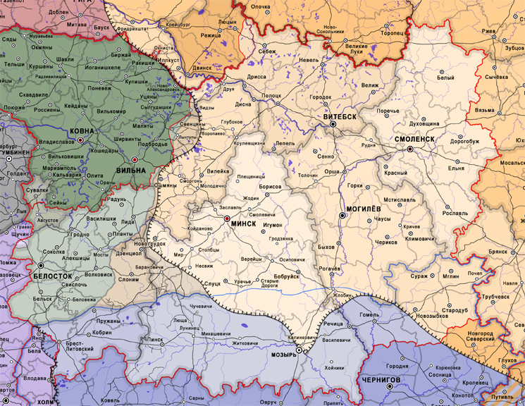
 francis-maks.livejournal.com
Been meaning to track down the source of these (there are several used in various Wiki entries) for a while, but just now got around to it...
francis-maks.livejournal.com
Been meaning to track down the source of these (there are several used in various Wiki entries) for a while, but just now got around to it...
1919.I.1 Провозглашение Советской Социалистической Республики Белоруссии
Западная Коммуна с интернациональным руководством вполне устаивала ЦК РКП(б) пока речь шла только о немецкой оккупации. Рано или поздно занятые территории были бы возвращены. Белорусские националисты в расчёт не брались. "Буржуазные" (БНР) сколь-нибудь заметной силой не стали. От "своих" (в лице…
francis-maks.livejournal.com
Nice, I wonder how the Interwar period would have changed if Lit-Bel consolidated. Would it have made it easier for the Soviets to defeat Poland in 1920? Would it have made it harder for Germany to invade the USSR during WWII? Who knows.Don't know if anyone's ever posted this before, but here's an old LiveJournal link to a series of maps posted by a user named Francis Maks, which shows (among others) the proposed and/or "ephemeral" borders of the Lithuanian SSR, Lit-Bel, the Socialist Soviet Republic of Byelorussia, etc, in the immediate post-WWI years. Maps are highly detailed, some of the best I've seen - so long as your Cyrillic comprehension is pretty good
Been meaning to track down the source of these (there are several used in various Wiki entries) for a while, but just now got around to it...1919.I.1 Провозглашение Советской Социалистической Республики Белоруссии
Западная Коммуна с интернациональным руководством вполне устаивала ЦК РКП(б) пока речь шла только о немецкой оккупации. Рано или поздно занятые территории были бы возвращены. Белорусские националисты в расчёт не брались. "Буржуазные" (БНР) сколь-нибудь заметной силой не стали. От "своих" (в лице…
Good questions... the hard part would be holding it together though. The memories of Lithuanians and White Ruthenes being united, more or less peacefully, in the Commonwealth and in the Grand Duchy, were getting more and more remote... and apart from a fading historical connection and a devotion to the Red Cause (held by a rather small portion of the population), there really wasn't much to hold Lithuanians and Belarusians together in a Lit-bel...Nice, I wonder how the Interwar period would have changed if Lit-Bel consolidated. Would it have made it easier for the Soviets to defeat Poland in 1920? Would it have made it harder for Germany to invade the USSR during WWII? Who knows.
Have you checked out the other links in the LJ yet? Holy crap the guy has a lot of maps! I was only familiar with a couple from the 1918-19 period, but he's got a LOT more of them...
Yeah, and I'm surprised there aren't irredentists in the exiled democratic Belarusian government that would claim the lands of the old BNR today.Have you checked out the other links in the LJ yet?
Apparently, there was a proposal from late WW2 to revive the Fiume Free State which existed from 1921 till 1924:
Unfortunately, though, i've found no maps to represent this proposal. But i know it would have been larger than the older 1920's proposal drawn here:
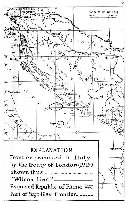
With the surrender of Italy in the Second World War, the "Fiume-Rijeka" issue resurfaced. In 1944 a group of citizens issued the Liburnia Memorandum,[13] in which it was recommended that a confederate state be formed from the three cantons of Fiume, Sušak and Ilirska Bistrica. The islands of Krk (Veglia), Cres (Cherso) and Lošinj (Lussino) would enter the common condominium as well.[14] President Zanella of the government-in-exile still sought the re-establishment of the Free State.[15]
Unfortunately, though, i've found no maps to represent this proposal. But i know it would have been larger than the older 1920's proposal drawn here:
Tbh the Allies should have made the whole Istria as a neutral state to separate Italy from YugoslaviaUnfortunately, though, i've found no maps to represent this proposal. But i know it would have been larger than the older 1920's proposal drawn here:
Better yet, Austrian outlet to the seaTbh the Allies should have made the whole Istria as a neutral state to separate Italy from Yugoslavia
Or Czechoslovak.Better yet, Austrian outlet to the sea
even better idea: give it to boliviaOr Czechoslovak.
Proposals for a border between British Egypt and the Ottoman Empire prior to the 1902 arbitration, which set the border we know today between the Levant proper and the Sinai.
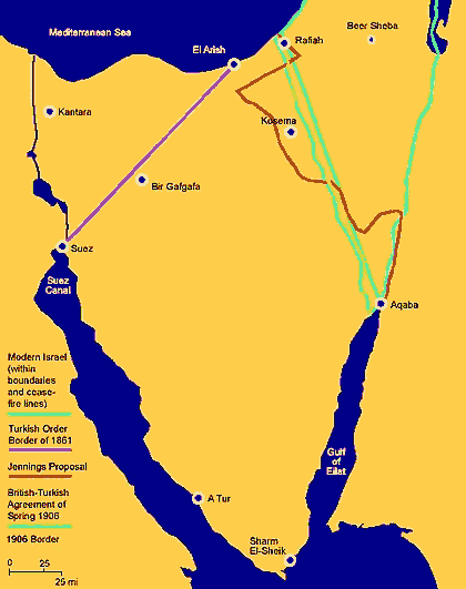
I'm intrigued by that "Jennings Proposal" line... Looks pretty specific in an area that doesn't lend itself very well to specificitiesProposals for a border between British Egypt and the Ottoman Empire prior to the 1902 arbitration, which set the border we know today between the Levant proper and the Sinai.
I've also seen a pre-1906 border that began at El Arish, but then followed the Wadi al-Arish a bit further into the Sinai... don't remember where I saw it now...
Bolivia needs a sea-coast back... might as well put it somewhereeven better idea: give it to bolivia
Pola should have remained Italian, historically, ethnically, and for prettier borders.Tbh the Allies should have made the whole Istria as a neutral state to separate Italy from Yugoslavia
Share: