You are using an out of date browser. It may not display this or other websites correctly.
You should upgrade or use an alternative browser.
You should upgrade or use an alternative browser.
Proposals and War Aims That Didn't Happen Map Thread
- Thread starter Beedok
- Start date
What
What
wait no i screwed up and thought they said something elseWhat
Reichskommissariat Turkestan, the furthest of Nazi Germany's proposed boundary with Japan's sphere

(can't speak Russia, someone translate pls)
(can't speak Russia, someone translate pls)
Crazy Boris
Banned
Reichskommissariat Turkestan, the furthest of Nazi Germany's proposed boundary with Japan's sphere
View attachment 529484
(can't speak Russia, someone translate pls)
Translated as best I can:
Reichkomissariat Turkestan
-Stable Territory
-Potential Parts (Turkic Formations)
-Chkalovsk Region as a link between Bashkiria and Turkestan
-Potential parts of Turkic formations
That last one should be "-Potential parts (non-Turkic formations)Translated as best I can:
Reichkomissariat Turkestan
-Stable Territory
-Potential Parts (Turkic Formations)
-Chkalovsk Region as a link between Bashkiria and Turkestan
-Potential parts of Turkic formations
Alfred Rosenberg's plan for dividing the USSR. OTL his Ostministerium had limited influence in the east, and his plans were never seriously considered.
Alfred Rosenberg's plan for dividing the USSR. OTL his Ostministerium had limited influence in the east, and his plans were never seriously considered.
Well for one, it included the names of Leningrad and Stalingrad... 😅 😅
And even the Nazis subscribe to the damned Kazakh Border...View attachment 530303
Alfred Rosenberg's plan for dividing the USSR. OTL his Ostministerium had limited influence in the east, and his plans were never seriously considered.
Well, at that time K-border was already existing...And even the Nazis subscribe to the damned Kazakh Border...
Fair enough, but that isn't large enough a Turkestan. There's still a lot of Tatars, Bashkirs, Chuvash, Altai etc. in Russia.Well, at that time K-border was already existing...
Interestingly though, the eastern border of Muscovy and Ural follows the Ob, Irtysh, and Tobol Rivers down to the Kazakh border.
If they ignored the Kazakh border in favor of following the Tobol River all the way down you'd end up with Kostanay, Ural instead of Kostanay, Turkestan as in the proposal.
Reichskommissariat Turkestan, the furthest of Nazi Germany's proposed boundary with Japan's sphere
That depends if we are talking about the 70° meridian east or the Yenisei River as the division of German and Japanese sphere of influence.
What did Japan plan to do with Siberia? I know that they wanted Russian land east of the Amur river and the Kamchatka peninsula, but that is all that I was able to find about it, as the majority of people in this forum know, Japan's expansion plans were even more batshit insane than the Nazis', they even wanted Colombia and Cuba, but it feels weird that they never mention Siberia anywhere (as far as I know) even though Siberia would fall in their post-war sphere.
For my ASB Axis plans wank map I guessed that Japan would just create a White Russian puppet state led by some exiled goon like Rodzaevsky, or as the Nazis intended, balkanize Siberia into various nations to be included on the Greater East Asia Co-Prosperity Sphere, I also assumed that Japan planned to expand Manchukuo to Outer Manchuria in the pre-1858 borders of the Qing Dynasty.
I'd imagine they would directly annex it or put it as first in line for Japonisation and successive annexation, due to the combo "low population - lot of resources". Also, there isn't really an abundance of local Asian cultures to permit the creation of puppet nations. And Pan-Asian Fascist Japan doesn't seems to me the type of regime that would allow European controlled states in its inner sphere.For my ASB Axis plans wank map I guessed that Japan would just create a White Russian puppet state led by some exiled goon like Rodzaevsky, or as the Nazis intended, balkanize Siberia into various nations to be included on the Greater East Asia Co-Prosperity Sphere, I also assumed that Japan planned to expand Manchukuo to Outer Manchuria in the pre-1858 borders of the Qing Dynasty
Did Atatürk imply that Kurdish ought to be second official language of Turkey?According to reddit this was Atatürk's vision what Turkey's borders should be.
View attachment 530828
Though I'm a bit skeptical since it seemingly doesn't include Cyprus despite having a sizable Turkish community.
He's already done a bit more than imply that the Kurds can't live within 300 miles of Turkey, at any rateDid Atatürk imply that Kurdish ought to be second official language of Turkey?
I suspect he thought they would be fundamentally assimilatable, like the Greek and Slavic Muslims who fled the Balkans and the refugees from Russia... that did not work out of course....Did Atatürk imply that Kurdish ought to be second official language of Turkey?
xsampa
Banned
What about settlement and assimilation of Russians in Russian majority areas, and creating Buryat nations and other Native Siberian nations?I'd imagine they would directly annex it or put it as first in line for Japonisation and successive annexation, due to the combo "low population - lot of resources". Also, there isn't really an abundance of local Asian cultures to permit the creation of puppet nations. And Pan-Asian Fascist Japan doesn't seems to me the type of regime that would allow European controlled states in its inner sphere.
Proposed administrative divisions of the Spanish Republic under the federal and cantonalist 1873 constitution
In 1945-1947 as States/Lander were being formed within the various occupation zones in Germany, the future Minister-President of the State of Hanover (formed in August 1946 and precursor to the State of Lower Saxony), Hinrich Wilhelm Kopf, had been suggesting (based off of a 1920s reform plan for the administration within the German Empire) from June 1945 through to April 1946 that a State of Lower Saxony be formed incorporating Hannover, Brunswick, Oldenburg, Schaumburg-Lippe (which are the areas that formed the current State/Land of Lower Saxony) as well as the former Prussian district of Minden-Ravensberg, the district of Tecklenburg and the state of Lippe. These latter territories ended up in what is now North Rhine-Westphalia, but had they been incorporated into Lower Saxony it would have looked like this:

Dark Red - State of Hannover
Light Red - Brunswick, Oldenburg, and Schaumburg-Lippe later added to form Lower Saxony with the State of Hannover
Light purple - Minden-Ravensberg, Tecklenburg and Lippe
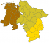
A counter-proposal by politicians from Oldenburg and Brunswick would have seen what is now Lower Saxony divided into roughly 3 equal states:
Weser-Ems (brown on the map below), Hannover (mustard on the map), and an enlarged Brunswick (gold on the map)

Edit (added Bremen to Weser-Ems)
Dark Red - State of Hannover
Light Red - Brunswick, Oldenburg, and Schaumburg-Lippe later added to form Lower Saxony with the State of Hannover
Light purple - Minden-Ravensberg, Tecklenburg and Lippe
A counter-proposal by politicians from Oldenburg and Brunswick would have seen what is now Lower Saxony divided into roughly 3 equal states:
Weser-Ems (brown on the map below), Hannover (mustard on the map), and an enlarged Brunswick (gold on the map)
Edit (added Bremen to Weser-Ems)
Attachments
Last edited:
Share: