They do indeed, specifically something on the proposed territory of Nataqua.I wonder if they have anything on Nevada
You are using an out of date browser. It may not display this or other websites correctly.
You should upgrade or use an alternative browser.
You should upgrade or use an alternative browser.
Proposals and War Aims That Didn't Happen Map Thread
- Thread starter Beedok
- Start date
You don't say? Gee I never would have thought that the idea of destroying Warsaw and replacing it with a small lame town to satisfy some demented ideology is a bad thing s/.Nazis ruin everything.
Can someone make a WorldA of this proposal? It was a proposal to make an autonomous canton in the mountainous regions of northern Greece, populated by a large proportion of Aromanians, a people living in northern Greece and Northern Macedonia who speak Aromanian, a dialect of Romanian.
  
 
Ahhh yes, that museum. I remember reading in a book about it and how they described- Well, you know how thousands of people died in the Holocaust from decapitation? Yah, they took the healthiest people (as in those not starving) in camps and would sometimes decapitate them so they had skulls for the museums, in which they could use as examples of their phrenology nose and ears base pseudo science. I do have to wonder about why there seems to be big slops on both sides of the road. And just look at those crane said in the distance..l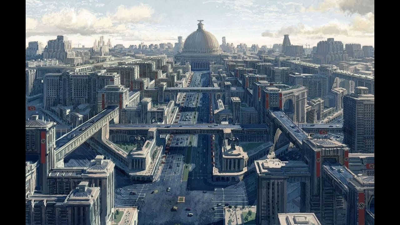
Here we have Hitler's plan for the reconstruction of Berlin into a grand capital for his Thousand-Year Reich. Designed largely by Albert Speer, it would've featured the following, among many others:
* The Volkshalle- Probably the most famous and the centerpiece of the whole project, the Volkshalle was to be a massive domed amphitheater capable of seating 180,000 people at a time. At 290 meters (950 ft) tall, it would've been bigger than the Great Pyramid of Giza, and would have become host to its own microclimate just from the people inside breathing.
* A triumphal arc measuring 117 meters (383 ft) high and 170 meters (557 ft) wide, which would have been erected after World War II and would have included the names of all Germans who had fallen in past wars.
* Massive new systems of roads, autobahns, and railways. Berlin was to be reorganized along a central 5km (3 mi) boulevard known as the Prachtallee, or Victory Avenue.
* The former Anhalter Bahnhof made into a public swimming pool.
A few of the goals of the project, like widening Charlottenburger Chaussee and placing the Berlin victory column in the center, have stuck around to the present day.
Outside Berlin, a few other buildings the Nazis planned were:
* Deutsches Stadion- A massive stadium in Nuremberg, able to seat 405,000 people at a time. It was going to be host to all Olympic games for the rest of history had the Nazis won.
* The Museum to the Extinct Race- The Jewish Museum in Prague was to be reorganized and basically used as a propaganda tool to teach future generations a distorted view of the Jewish people and how the Nazis "freed" Europe from them.
So since Bougainville had that referendum I was doing some reading on the history of PNG and discovered that France actually tried to colonize it as "New France"! It went horribly.
Attachments
So since Bougainville had that referendum I was doing some reading on the history of PNG and discovered that France actually tried to colonize it as "New France"! It went horribly.
A French PNG would be really interesting if someone (who is much better than me) could do a TL about it. I wonder if New Caledonia, and even the New Hebrides might be attached to it, along with some other French islands in the pacific.
Honestly the request thread might be up for it, and also, Aromanian's status as a language or dialect is really up for debate.Can someone make a WorldA of this proposal? It was a proposal to make an autonomous canton in the mountainous regions of northern Greece, populated by a large proportion of Aromanians, a people living in northern Greece and Northern Macedonia who speak Aromanian, a dialect of Romanian. 
It'd be cool to see what develops instead of Tok Pisin but I wish there was a larger map as thats the biggest I can findA French PNG would be really interesting if someone (who is much better than me) could do a TL about it. I wonder if New Caledonia, and even the New Hebrides might be attached to it, along with some other French islands in the pacific.
It'd be cool to see what develops instead of Tok Pisin but I wish there was a larger map as thats the biggest I can find
I would assume it would be based off of French rather than English. Maybe something like Tayo Creole?
So since Bougainville had that referendum I was doing some reading on the history of PNG and discovered that France actually tried to colonize it as "New France"! It went horribly.
Fun fact: the Marquis de Rays actually initially planned to found Port Breton, the main port of the New France colony... in northern Western Australia.
Which at the time was british, and (the colony as a whole) had existed for over 50 years and had dozens of thousands of inhabitant....
“newspaper reported that the Marquis de Rays, a grandiose French aristocrat, intended to take advantage of the emptiness of Western Australia’s north by establishing a colony there, to be called Port Breton. Eventually, the marquis took his luckless colonists to New Britain*, o the coast of New Guinea, where the enterprise soon failed.”
-Land of Vision and Mirage, Western Australia since 1826 by Geoffrey Bolton
* new Ireland is part of the New Britain archipelago.
Worlda isn't a program or anything. Worlda is the name of the base map used by most people who make maps on here. It's the standard map you usually see on here. It was ready the first time the same blank map template was used widely, so it was sorta a form of standardisation for mapmaking on this forum.What is WorldA? I Know it's some kind of map thing, but I can't find it when I search it up on Google.
So, uhh, Marc Pasquin made this great map of the proposed Principality of the Pindus after I posted about it in the map request thread.
According to the notice on the lower left, the limit of the territorial claim for Pindus is the line made of plus signs so that the southern part should be excluded as below. The pink part is meant to represent all territories were the vlachs form a majority of the population.
The place names appear to be written in Albanian.
If it helps, the lake called "Janina" in the lower left is Ioannina (Greece). Mekovo near the southern border is Metsovo, Perivoli (center) is also called Perivoli in greek, Grevena (north-western border) is also Grevena and Gramosta (northern border) is mount Gramos. I assume that most other placename should be similar enough to be recognisable.
View attachment 508335
funnily enough, i think i have/had it in the cards that New Guinea really is a French possession in my ASB ATLA French PNG would be really interesting if someone (who is much better than me) could do a TL about it. I wonder if New Caledonia, and even the New Hebrides might be attached to it, along with some other French islands in the pacific.

i've heard alot of mapmakers remark on paint.net, personally i used photoshop (haven't had access to the program in a long, long time, though--been meaning to get it back in large part because i have a metric fuckton of new ideas that i want to properly visualize, alot of them inspired by this very thread)So what programs do people use when they use this standardized map? Or does it vary?
I'm reminded a helluva lot of the Poyais scheme that also went horrifically wrongFun fact: the Marquis de Rays actually initially planned to found Port Breton, the main port of the New France colony... in northern Western Australia.
Which at the time was british, and (the colony as a whole) had existed for over 50 years and had dozens of thousands of inhabitant....
“newspaper reported that the Marquis de Rays, a grandiose French aristocrat, intended to take advantage of the emptiness of Western Australia’s north by establishing a colony there, to be called Port Breton. Eventually, the marquis took his luckless colonists to New Britain*, o the coast of New Guinea, where the enterprise soon failed.”
-Land of Vision and Mirage, Western Australia since 1826 by Geoffrey Bolton
* new Ireland is part of the New Britain archipelago.
Was it? Wasn't there a pre-worlda template used in the original map threads that fulfilled the same purpose?Worlda isn't a program or anything. Worlda is the name of the base map used by most people who make maps on here. It's the standard map you usually see on here. It was ready the first time the same blank map template was used widely, so it was sorta a form of standardisation for mapmaking on this forum.
Yeah, but worlda caught on despite the other one.Was it? Wasn't there a pre-worlda template used in the original map threads that fulfilled the same purpose?
What's the problem?Okay whose idea was it to put Shanxi and Xing'an in the same administrative unit?
Shanxi and Hebei is an unusual grouping to begin with, since they're separated by mountains with only a few passes, while Hebei has a river connection to Henan and Shandong has no mountains in the way. The really outrageous thing is the way it awkwardly slices through Inner Mongolia.What's the problem?
The whole unit is a bit like Libya annexing Sudan and Algeria.

The original plan for the Golden Gate Bridge was to paint it with a dazzle pattern, similar to what used on ships during World War I, as a way to make it more apparent in the bay's fog. This bumblebee pattern is just one option; another was to paint it like a candy cane. Then it was found that bright orange stood out much better, and so the bridge was painted the color we know.
Share: