Germanophobia galore, as if Germany is a rapacious beast intent on domination.For Germany to have no territorial grievances against Poland the latter would have to be already strangled
You are using an out of date browser. It may not display this or other websites correctly.
You should upgrade or use an alternative browser.
You should upgrade or use an alternative browser.
Proposals and War Aims That Didn't Happen Map Thread
- Thread starter Beedok
- Start date
Instead of discussing which nation should have controlled the Free City of Danzig after 1918 whe should discussing how to abandon nationalism. Territorial disputes are a good example of the dangers and the stupidity of it. (I mean there are always minorities, and "clean" borders are impossible unless you enact horrible policies since there are always minorities and villages with a minority majority. Just abandon the idea that a "nation" needs a leading ethnicity.
Crazy Boris
Banned
Remember when this thread was about maps
Let's go back to that
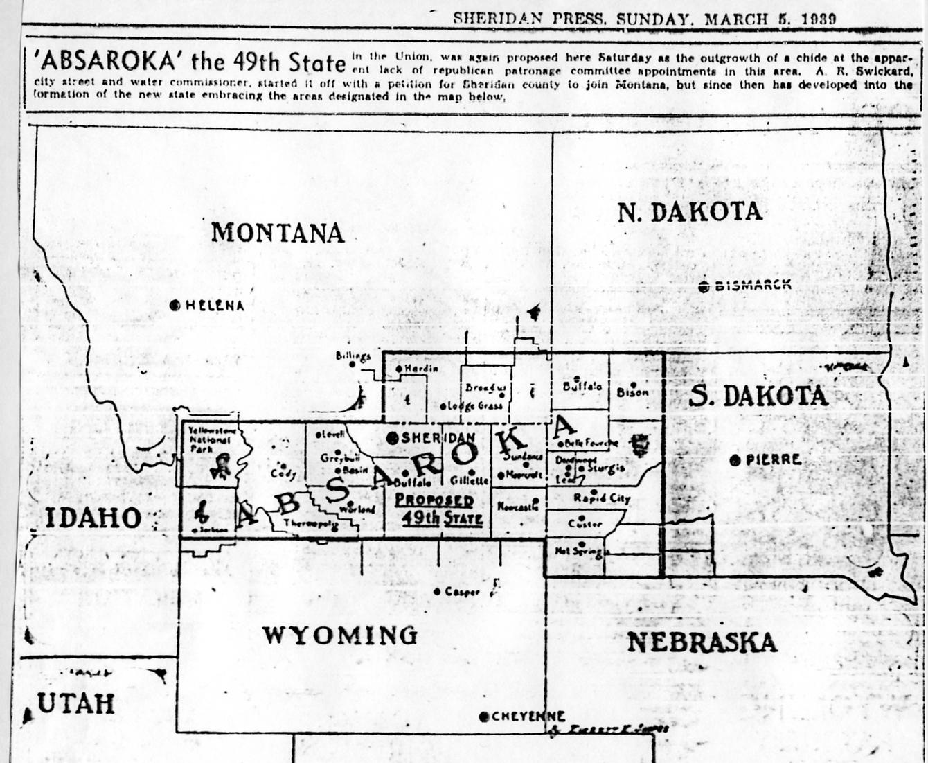
here's an Absaroka
Let's go back to that
here's an Absaroka
I hope Buffalo and Bison have a Springfield/Shelbyville-esque rivalry with one another.
Yes, like our history shows, after giving up territory claimed by Germany (Sudetenland) Czechs were left in peace.Germanophobia galore, as if Germany is a rapacious beast intent on domination.
Oh, wait a moment...
Remember when this thread was about maps
Let's go back to that
here's an Absaroka
Well said, Crazy Boris. Well said.
My main question is who the heck would live in this new state; from what I understand, Wyoming and the Dakotas aren't exactly bustling already.
Well said, Crazy Boris. Well said.
My main question is who the heck would live in this new state; from what I understand, Wyoming and the Dakotas aren't exactly bustling already.
A quick look at the major cities in the area reveals a population of around... 130,000, but since there's also a lot of towns and villages in there... I'd guesstimate 200,000 souls at most in 2018, which would make it the least populated state in the Union by far. And based on what I did in terms of research on it, they were 1) banking on that sweet tourism money coming in from Mount Rushmore and Yellowstone, and 2) they hoped that they could present a united front against FDR's New Deal, which the people in those remote areas of their states were against, but their relative isolation and disunity meant that they didn't have the ability to "resist" that policy.
So the low population is kinda by design: all three areas are rural backwaters located in already rural backwaters.
Also here's something interesting I found on my hard drive.

Some proposed borders of Tibet. I can't remember where I found it, but I'm pretty sure it wasn't in this thread. Also while the map labels this as being from the Simla Conference, it's actually from the Simla Accord of 1914.
Last edited:
A quick look at the major cities in the area reveals a population of around... 130,000, but since there's also a lot of towns and villages in there... I'd guesstimate 200,000 souls at most in 2018, which would make it the least populated state in the Union by far. And based on what I did in terms of research on it, they were 1) banking on that sweet tourism money coming in from Mount Rushmore and Yellowstone, and 2) they hoped that they could present a united front against FDR's New Deal, which the people in those remote areas of their states were against, but their relative isolation and disunity meant that they didn't have the ability to "resist" that policy.
So the low population is kinda by design: all three areas are rural backwaters located in already rural backwaters.
Also here's something interesting I found on my hard drive.
Some proposed borders of Tibet. I can't remember where I found it, but I'm pretty sure it wasn't in this thread. Also while the map labels this as being from the Simla Conference, it's actually from the Simla Accord of 1914.
I remember that book. I can't remember the name of that book. But I do remember that book. Unfortunately I don't have it. From what I can recall it's a very good and detailed book on Tibetan history.
EDIT: A google search suggests it came from this book from 1988: "Himalayan triangle: a historical survey of British India's relations with Tibet, Sikkim and Bhutan 1765-1950" but I seem to recall it from another book that was written in the late 1990s or early 2000s.
Right, Poland would do great without Greater Poland, Upper Silesia, Pomerania and those bits and pieces of Congress Poland Germany wanted for themselves. Industry, developed agriculture, sea access and not being completely devastated by war is so overrated.Germanophobia galore, as if Germany is a rapacious beast intent on domination.
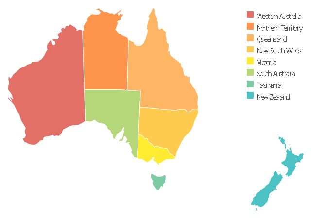
From 1883 to 1901, New Zealand was a member of the Federal Council of Australasia and the way seemed clear for it to become a state of Australia. However, in 1901, New Zealand refused to become a state of Australia in response to Australia's discriminatory policies against the Aborigines. New Zealand had a positive relationship with the Maoris and did not want that progress erased by membership in a country which treated it's non-white inhabitants as inferior to whites.
Australia was so desperate for New Zealand to become a state that in 1902, the government gave Maoris right to vote, whereas Australia's actual natives, the Aborigines, did not get suffrage until 1967.
That's a map of the situation as it would be today right? Not in 1902 yes? Because until 1911, Northern Territory was a part of South Australia
I couldn't find a map of Australia just after Federation with New Zealand in it. I had to make do.
Okay. That's fine.
We're all here to help as well. So here you go ;-)
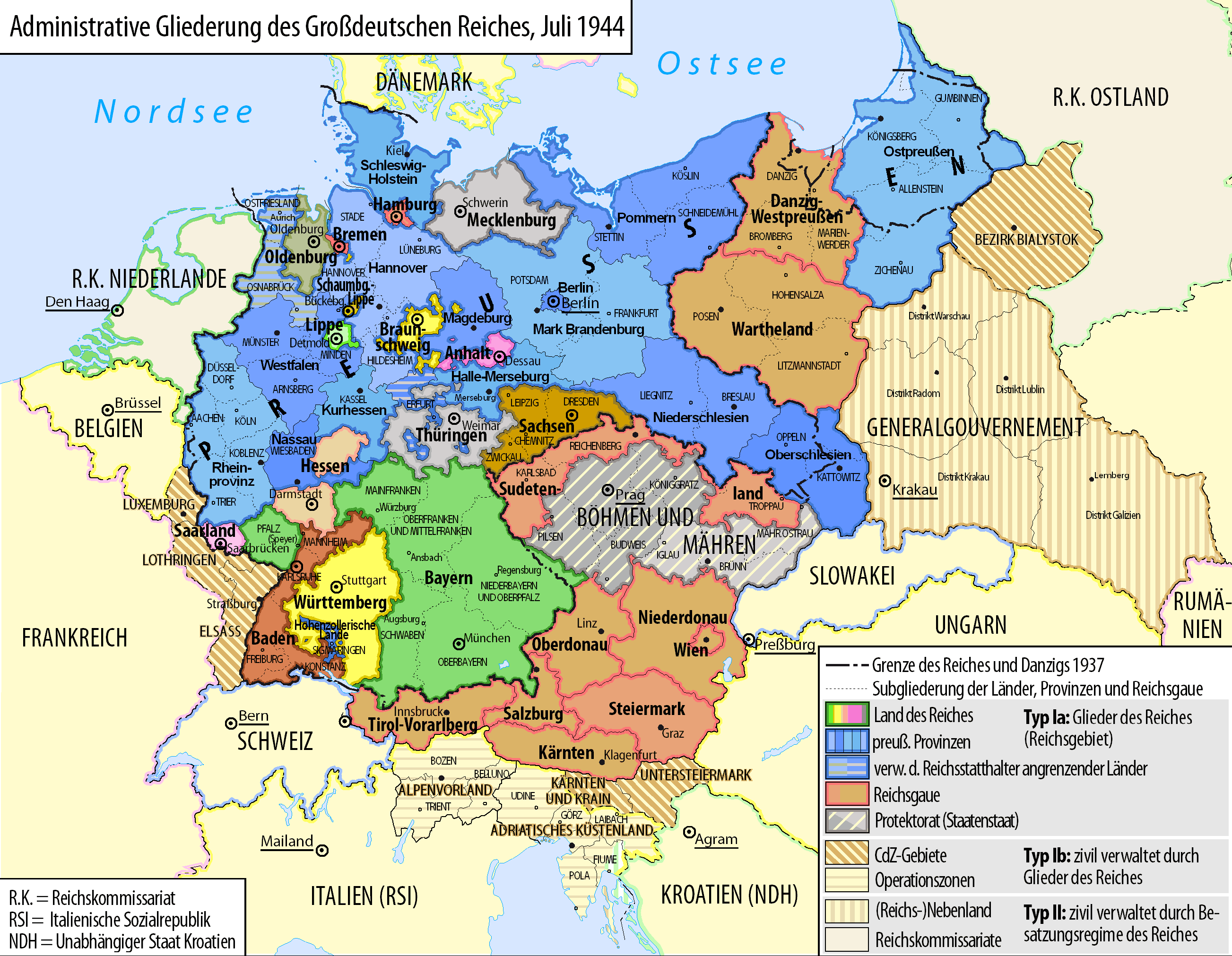
Another find, mostly interesting because it shows the de jure situation in Nazi Germany with the Länder still intact, rather than showing just the Reichsgaue. What's super fascinating, and something I only learned today, is that the Kleinwesertal in the Austrian state of Vorarlberg was annexed to Bavaria after the Anschluss in 1938. Also I like how this map also shows stuff like Baden's provinces and the like. Quite the good level of detail.
Philip
Donor
here's an Absaroka
So that's actually a thing. Hadn't heard of that one before. It's getting rather close to 1 farmer and 2 senators.
Treatment of Indigenous peoples' was a factor in New Zealand refusing to federate, but it was far from the only reason - or even the main reason. The main reason, afaik, was simply that the Kiwis already had a separate identity - the fact that their leader at the time imagined the country as being a 'Britain of the South Seas' that would become very powerful and wealthy also certainly contributed to this. Another factor was their fear of a lack of representation, they didn't want to be ignored in favour of 'continental issues' and constantly outvoted due to being only a single state, like many Tasmanians claim they are even today (some people have proposed having the north & south island be separate states to try and alleviate this problem but I don't if this proposal was around at the time or whether it would have been taken seriously if it was).
From 1883 to 1901, New Zealand was a member of the Federal Council of Australasia and the way seemed clear for it to become a state of Australia. However, in 1901, New Zealand refused to become a state of Australia in response to Australia's discriminatory policies against the Aborigines. New Zealand had a positive relationship with the Maoris and did not want that progress erased by membership in a country which treated it's non-white inhabitants as inferior to whites.
Australia was so desperate for New Zealand to become a state that in 1902, the government gave Maoris right to vote, whereas Australia's actual natives, the Aborigines, did not get suffrage until 1967.
Not even mentioning, that Germans supported Ukrainian and Lithuanian claims against Poland during ww1 (Germans regarded them as weaker than Poles and more reliable as allies), so say goodbay also to Chełm, Białystok and Suwałki (not even mentioning Lwów and Wilno).Right, Poland would do great without Greater Poland, Upper Silesia, Pomerania and those bits and pieces of Congress Poland Germany wanted for themselves. Industry, developed agriculture, sea access and not being completely devastated by war is so overrated.
Remember when this thread was about maps
Let's go back to that
here's an Absaroka
Absaroka M-Bam!
I feel like you might be misunderstanding my point. I am not saying that Poland should just have conceded before all German demands. I am arguing that instead of heeding abstract notions of economic independence, the delegates at Versailles should have implemented self-determination, allowing those provinces where the populace desired to either remain or become united with Germany to do so, thus preventing much acrimony further down the road.Right, Poland would do great without Greater Poland, Upper Silesia, Pomerania and those bits and pieces of Congress Poland Germany wanted for themselves. Industry, developed agriculture, sea access and not being completely devastated by war is so overrated.
The Czechs were dealing with a Germany that was already under a radical government whose rise to power was fueled by a sense of anti-German discrimination by the international community, a sentiment rooted in the fact that many territories that desired to be German were severed from their nation. If lands that desired to remain German were given the option to do so, as opposed to being conjoined with a foreign state, one could argue that the rise of the government that made such thuggish demands towards Czechoslovakia would never have manifested in the first place.Yes, like our history shows, after giving up territory claimed by Germany (Sudetenland) Czechs were left in peace.
Oh, wait a moment...
But that's not what Germany wanted - the wanted pre-1914 borders and economic and political subjugation of rump Poland. Literally every interwar German government and every political force was quite open about it and worked towards that end.I feel like you might be misunderstanding my point. I am not saying that Poland should just have conceded before all German demands. I am arguing that instead of heeding abstract notions of economic independence, the delegates at Versailles should have implemented self-determination, allowing those provinces where the populace desired to either remain or become united with Germany to do so, thus preventing much acrimony further down the road..
Is it acceptable to repost maps from earlier in the thread? For example, I realized I had posted a map of Armenia which had been posted before, and the map of Tibet on the previous page had been posted a couple months ago.
If so, there are some maps from a while ago that might benefit from reposting.
If so, there are some maps from a while ago that might benefit from reposting.
Share: