Planetocopia Map Thread

3hataamoy9p91.png


3t9a14ouy9p91.png


tekapb4sy9p91.png


Elevation-2.png


Elevation.png


Elevation-1.png


Topography.png


Topography-1.png


Topography-2.png


Extended_River.png


Less_Rivers.png


115_million_years_ago.png
You know, I was looking at that lower map for bit, having no idea what it was, and thinking "huh, this looks a lot like Paleozoic Earth, with Laurentia and Baltica as two islands floating next to huge Gondwana, only flipped north-south so Gondwana is on top", and then I realised it was actually just the immediate aftermath of the breakup of Pangaea. And then I looked a bit closer at the other images, and noticed that they recogniseably have a similar pattern.

In fact, if you move the south pole about to the mid-Atlantic, there is actually a disconcerting similarity between the modern layout of the continents and Paleozoic Earth. It's quite different, yes, but even though Gondwana has broken up, its constituents haven't gone that far, they're still all pretty close to each other. Turns out, there really hasn't been that much continent drift, and the continents 500 million years ago were substantially about where they are today.

generated_with_worldmapgenerator-6.png

1664782148584.png


Now this makes me wonder how similar the reverse would look - Paleozoic Gondwana moved to about where its modern descendents are. Unfortunately, I don't have the software to do this.
 
I know someone in this thread mentioned Lake Malaren near Stockholm might be around 400m higher if it weren't for Pleistocene isostatic depression. For Antarctica a study I posted an image from earlier determined that isostatic depression decreased elevation around 200m by the coast, but 1000m or more toward the center of the ice-sheet. There is also erosion to consider, which can decrease elevation in mountainous areas by a further 1000m or more on top of the isostatic depression. In flatter areas the depression due to erosion is around 250m give or take. So it doesn't just lower altitude by a fixed amount, but evens it out like an iron due to erosion.

This gives us a range from coast to center of the ice cap of -450m to -2000m in flat areas, and -1250m to -2500m in mountainous areas.


Below are two maps from the study and the caption associated with it. You can read the study here, or at ResearchGate I think.

View attachment 778358

View attachment 778362
View attachment 778366
View attachment 778367
Okay I am a bit confused by this. While I get the highest point in Antarctica would be around 2500 metres higher than what a sudden modern defrost Antarctica would have, does the 450m in flatter areas mean the coast should be 200ish to 450 metres below sea level or does the forces of erosion mean that there'll be no extended coast, infact, maybe the coast would be receded without the 200m of deposition?.

The coast remains around the same as OTL in the 35 million years ago map.

1-s2.0-S0031018219304845-gr6_lrg.jpg


The 2nd reason for all this talk of comparisons is Arctic Africa of Jaredia. Would the Coastline change much? All of Jaredia that I'm drawing will have a coastline of about 90 metres above Sea Level.

Would Arctic Africa be the same? Would the 200 metres of Erosion mean it'll be 100 metres below sea level at coastline or would the erosion pile up enough that it'll be less (like 50) or straight up reverse (Like OTL Sea level) or would it much like Antarctica be largely the same Sea Level as the rest of the world with the exception of areas that became particularly prone to erosion.?.
 
Jaredia_Drawing.png


Iranian Lakes, Done.
Jaredia_Drawing.png


*East Coast.

You know, I just remembered that Canada has like a bazillion tiny lakes and that with Europe, maybe even Eastern Europe being the closest equivalent to that, it too should have like a bazillion lakes.

Also, what do you think about much of the length of the Volga river being flooded like it is on all ice melted maps. Maybe it even have sections that are like the Canadian lakes if the whole thing isn't just flooded into a narrow lake.
 
Saglek+Delta.png


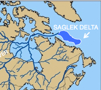
The Bell River flowed eventually to the area of modern day Hudson Bay and the Hudson Strait to the Labrador Sea. It ended in the Saglek delta which is the largest depositional basin between Baffin Island and Florida. It contains a 5-mile thick section of sediment. Recently released geoinformation from oil companies shows that the Saglek deposits contain Pennsylvanian age (about 300 million years ago) pollen fossils that were transported from their source rocks by this ancient river.

Was reading and came across this. Anyone know about the Oil Companies generated map of the Saglek Delta/Depositional Basin?.

Also, anyone know of how the Canadian Shield/Laurentide Shield looked before the start of repeated Glaciation?.

The Wiki says it was very mountainous but was worn down by Glacier erosion I would assume if not for Glaciers it would be worn down anyways but only a little more than the Rockies own wearing down.

So, anybody know of any academic stuff on how it looked or would have looked without Glacial erosion?.

Canada_geological_map.JPG
 
Saglek+Delta.png


Was reading and came across this. Anyone know about the Oil Companies generated map of the Saglek Delta/Depositional Basin?.

Also, anyone know of how the Canadian Shield/Laurentide Shield looked before the start of repeated Glaciation?.

The Wiki says it was very mountainous but was worn down by Glacier erosion I would assume if not for Glaciers it would be worn down anyways but only a little more than the Rockies own wearing down.

So, anybody know of any academic stuff on how it looked or would have looked without Glacial erosion?.

Canada_geological_map.JPG

I don't think we can know for sure but the Saglek Delta/Bell river thing is interesting. I think Labrador would be range of coastal hills and Hudson bay itself looks like it would be dry land and a low lying basin. Do you know if the off shore islands on the map before this are the result of glacial deposition? I'm pretty sure cape cod and the associated islands are for example.
 
I don't think we can know for sure but the Saglek Delta/Bell river thing is interesting. I think Labrador would be range of coastal hills and Hudson bay itself looks like it would be dry land and a low lying basin. Do you know if the off shore islands on the map before this are the result of glacial deposition? I'm pretty sure cape cod and the associated islands are for example.
For the Hudson Bay, Thank God for Christopher Scotese's videos on continental drift, I at least now have a rough trace for that one.

Well, I guess I'll just continue the search for the Saglek. Given the Glaciers could erode the Canadian Shield so much, a little Delta isn't much for them.

The Islands to the North of Canada and West of Greeland are definitely not deposits, but those are the ones I am sure of now.
 
Okay I am a bit confused by this. While I get the highest point in Antarctica would be around 2500 metres higher than what a sudden modern defrost Antarctica would have, does the 450m in flatter areas mean the coast should be 200ish to 450 metres below sea level or does the forces of erosion mean that there'll be no extended coast, infact, maybe the coast would be receded without the 200m of deposition?.
It depends, you can see certain areas of Antarctica were inundated while others changed very little. Notice that the areas where the change was small tend to be areas of steep coastal escarpment. Just to clarify: What I meant by depression due to erosion is that it would lower the elevation further, apologies if that was unclear. This does bring up glacial deposition, which can create post-glacial landforms along the coast like Cape Cod in North America, however the Antarctica study does not actually take that into account in their model. Feel free to use this as an excuse for artistic liberties.
The 2nd reason for all this talk of comparisons is Arctic Africa of Jaredia. Would the Coastline change much? All of Jaredia that I'm drawing will have a coastline of about 90 metres above Sea Level.

Would Arctic Africa be the same? Would the 200 metres of Erosion mean it'll be 100 metres below sea level at coastline or would the erosion pile up enough that it'll be less (like 50) or straight up reverse (Like OTL Sea level) or would it much like Antarctica be largely the same Sea Level as the rest of the world with the exception of areas that became particularly prone to erosion.?.
Just like you see in Antarctica, the change in coastline would vary and depend on the off-coast bathymetry. The coast of Namibia would change very little, while chunks of the Sahara might be inundated or depressed below sea-level. the lower plains of Mozambique and the Niger Delta would also certainly be below sea level in Jaredia. Southern Africa looks like it will be akin to OTL Greenland, a glacial bowl with a coastal escarpment and areas in the center much lower.

Overall ballpark is probably good enough on this.
 
Last edited:
In fact, if you move the south pole about to the mid-Atlantic, there is actually a disconcerting similarity between the modern layout of the continents and Paleozoic Earth. It's quite different, yes, but even though Gondwana has broken up, its constituents haven't gone that far, they're still all pretty close to each other. Turns out, there really hasn't been that much continent drift, and the continents 500 million years ago were substantially about where they are today.

generated_with_worldmapgenerator-6.png
Dunno about the assertion shown given how fragmented the continents were at that time, but hasn’t someone already done a Cassini map like that? Like Seapole, I think that world would be warmer and wetter than our own.

I’ve started writing up the next update for Retrograde Earth (kind of equivalent to Turnovia but based off a study), this one focussing on North America around 500-600CE. I’ve managed to make out some rough changes to North America, but South America is more tricky. It will cover both ecology and the different human inhabitants of TTL americas. Anyone here got tips to work out such a continental layout?
East of the Andes is really dry, excepting the Amazon which is Tropical, and Patagonia which is Maritime. West of the Andes is humid besides maybe a small strip of far southern Chile which may host some dry valleys. Overall plenty of opportunities for irrigated civilizations to develop, I can see Wari and Tiwanaku-like highland cultures still forming in the Andes, then spreading down to the tropical humid and later to the temperate humid coast. In the east there are plenty of opportunities for Moche-like civilizations to form: Rio de la Plata, Brazilian Highlands, or even the Orinoco are much drier and suitable for agricultural civilizations. Even the Amazon Delta seems to be drier, and in OTL a fairly populous and complex culture, the Marijoara did form there, so maybe you can have them take a similar niche, but advancing further along the lines of how the desert-coast societies of Peru developed.
 
East of the Andes is really dry, excepting the Amazon which is Tropical, and Patagonia which is Maritime. West of the Andes is humid besides maybe a small strip of far southern Chile which may host some dry valleys. Overall plenty of opportunities for irrigated civilizations to develop, I can see Wari and Tiwanaku-like highland cultures still forming in the Andes, then spreading down to the tropical humid and later to the temperate humid coast. In the east there are plenty of opportunities for Moche-like civilizations to form: Rio de la Plata, Brazilian Highlands, or even the Orinoco are much drier and suitable for agricultural civilizations. Even the Amazon Delta seems to be drier, and in OTL a fairly populous and complex culture, the Marijoara did form there, so maybe you can have them take a similar niche, but advancing further along the lines of how the desert-coast societies of Peru developed.
Yeah the study as well as Wayan’s Turnovia suggested that southern Chile is cooler and drier than our own, whereas both northern Chile (including to a lesser extent Santiago itself) and Patagonia (Inc the Falklands) are warmer and much wetter, with northern Chile in particular having Equadorian humidity and a definitely warmer climate year round. Peru is wetter in both the highlands and lowlands, especially the latter, so as Wayan predicted, it would definitely be able to sustain a larger population than otl, and ittl it would not be blocked off in latitude due to a drier and more open Equador in the north and a fertile northern Chile in the south, with the Atacama ironically being a breadbasket here. As mentioned in one of my updates, the Galápagos Islands are significantly warmer and wetter than our own. This greener Peru and northern Chile, known as Xiphito in my timeline, would certainly be a major regional power and would likely avoid foreign conquest by eurasians i

A wetter and maritime Patagonia could also be a nice settler colony for any power from across the Atlantic, so it is possible that some equivalent of colonisation occurs in these americas, though the emphasis is different, and mostly not from Europeans. Indeed the good majority of TTL’s Eurasian population is concentrated across North Africa and Southern Asia, so that would be the more likely source of any invaders.

I like the ideas shown for Brazilian zones and peoples, these could certainly bring the region up to speed and help avoid being just stomped by west Africans arriving. The very large desert in southern Brazil and northern Argentina is obviously a big issue to habitability, but populations converging around smaller fertile zones could encourage development more. As you said, a somewhat similar position exists in ittl’s Congo, as it is wetter around the coast but somewhat drier inland, if still pretty wet, resulting in more savannah.

As for North America, as mentioned on the thread itself, the Midwest and centre has hotter summers but similar winters to otl, like Central Asia, and along with the drier climate likely results in a steppe climate, meaning a much larger and hotter Great Plains, that includes part of our Great Lakes (due to the east American ice cap during the ice age being smaller in this timeline due to milder winters and less rainfall). New England’s drier, warmer and less seasonal climate results in a Mediterranean biome now being found here, akin to otl Portugal for example. Newfoundland and Quebec are slightly drier and wetter respectively with milder winters, so it’s possible Canada would be more populous ittl, at least in the east. As mentioned before, Cascadia is mostly drier and more seasonal and continental than otl, whereas southern California, Baja and Sonora are warmer and much wetter, as are to a lesser extent, NoCal, Utah, Nevada, New Mexico and Chihuahua. Ittl, the much wetter California and easlink with Oregon can easily allow larger and more elaborate societies to form around the coast, just as with Peru, but with SoCal and Baja having an irl Florida like climate. Very little difference in either department in the Midwest proper.

A huge difference in the south and southeast of course, with Louisiana having average July temperatures well over 40C, akin to the hottest parts of otl Sahara and similar in humidity. Texas is even hotter and drier than our own, so not the most massive difference. Florida is relatively mild compared to the rest of the south, comparable to our Baja. The much hotter southern US is a far cry from our timeline, and that the heartland of otl Confederacy has a comparable climate to the Western Sahara (and vice versa here) is an amusing irony.

Most of the rest of Mexico is warmer and at least somewhat drier, with Mediterranean biome being present in much of the centre, while Yucatan is a desert or near it. Some of the maps have portrayed Central America as a desert in this timeline, though as mentioned due to the currents and actual humidity patterns, it probably isn’t as extreme as this for the most part, though it is certainly much drier than our own, along with most of the Carribbean. In fact there appears to have been a rough swap between the Caribbean islands and those of west Africa here in climate terms, with the former being cooler and drier than ours, whereas the Azores, Canaries and Verde are warmer and much wetter, as is Socotra on the other side of Africa.

Is there anything you think I missed or need to elaborate on?
I pretty much agree with the points mentioned, I will say that I think you should not discount the rivers from the leeward side of the Andes as possible centers of civilization. OTL Peru has numerous rivers cutting through the desert, and these valleys are where some of the very first civilizations in the entire Americas formed. I see an analogue to this in the Salado, Bermejo, and Pilcomayo rivers, except massively increased in scale with the inland delta of Rio De La Plata being rather Mesopotamian. Even the Amazon, while diminished from OTL with far fewer rivers in the basin, may host some complex societies at its delta. The Orinoco delta too is as dry as the OTL Indus, and I would not forget that the northern coast of South America is much more arid than you would expect at that latitude due to the very cold Carolina current stretching down the coast, an analogue to the Humboldt in OTL south America. Venezuela may have a climate similar to the coast of OTL Peru or Ecuador.

In North America, the Great Basin is another candidate for possible complexity. Its almost like Southern China but even more mountainous, the Colorado is the Changjiang, and the Central Valley might be like the Zhongyuan. (Central Plain) Not sure how much stronger the North American Monsoon is though, how much will decide where the forested hills and mountains of Nevada thin out into steppe. Western Oregon is definitely like a milder Mongolia, no matter how much stronger the North American Monsoon is, it won't match the OTL Asian Monsoon in breadth.
 
For the people on Jaredia, I am not to sure that the Hudson would be dry if we go by 26 metres drop that the World Map was using(Tho, it'll be half dry at my 82-6 metres drop).


Screenshot_20221020-160858.png


Earth, 3.7 million years ago before the last proper Ice age(which started 2.5 mil)

Screenshot_20221020-160955.png


Earth 6.3 million years ago, less Ice than today but similar Ice to today.

Screenshot_20221020-161123.png

Similar to today again but less Ice and similar to the water level for my Jaredia.

Screenshot_20221020-161151.png

Last time no Ice at all in the North.

All from. https://www.academia.edu/11082185/Atlas_of_Neogene_Paleogeographic_Maps 2014
 
Last edited:
Top