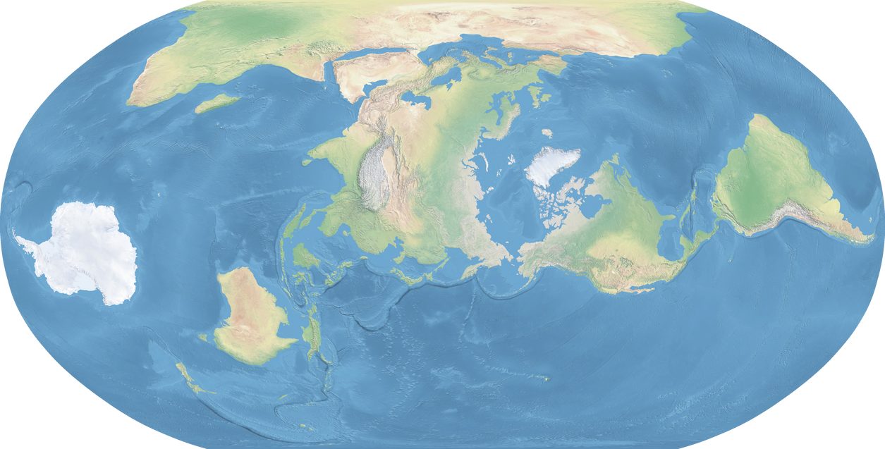
Are you sure the pacific coast of the neotropics are going to be that dry? They are right in the path of easterly winds and warm currents which I would think create an Af zone on the Peruvian Coast and Central America, and Am/Aw zones in the higher latitudes toward the Humid Subtropical climates in California/Chile. I can see a drier Oregan, but a Patagonian California seems like a stretch to me. Wouldn't it get monsoon rainfall a la OTL Australia (or East Asia)? Same goes for the Chilean coast but to a greater extent because I don't see any chance of the warm current being deflected away.
As I said, the map Molotov made was a WiP, so these critiques are probably very plausible, as he didn’t know about the videos at the time, just average
annual temperature and rainfall patterns. I agree as in my timeline that California and northwest Mexico are much more humid than otl, akin to Florida or Australia, and northern Chile based on humidity may be an outright rainforest ittl. Southern Chile is drier but southern Argentina is wetter as a counterbalance.
This is an amazing map and very detailed. How did you make it?? I think it is generally correct, however I do have some feedback...
Agreed that the California/Oregon coast should be wetter and not desert, due to the coastal warm current. Not sure about Chile, where I expect cold Antarctic waters will have more of an impact.
A few other things:
I think Central Argentina would be Csb (maybe Csa further inland up to the Andes foothills) due to being on the west coast and upwind of the Andes. I'd expect a climate similar to OTL central Chile or maybe southwest Australia, which has a similar flat topography.
I think the big Ds zone in Canada and New England would be a mix of Cfb (Newfoundland, Maritimes), Csb (Maine, New Hampshire, Vermont), Dfa (S, Ontario, N. Michigan) and Dfb (Quebec). I suspect this area is too low-lying and too far north to support continental dry-summer climates. I believe such climates only form in high-elevation inland locations that would otherwise be dry-summer steppes (borderline Csa/BSk climates) if they were closer to sea level.
Same goes for Siberia and Mongolia: Amur Valley would be Cfb, Mongolia would be Dfb. Overall, similar to OTL Europe at the same latitudes. I'd also expect a Mediterranean climate (Csa) in North Korea due to moisture coming off the Sea of Japan (think of the effect the Med/Adriatic has on OTL Greece).
In the North Pacific, Kamchatka would be warm due to the very warm current that would form in the north Pacific, possibly making it even warmer than OTL Britain. I'd guess it would have a Cfb climate in the lowlands, maybe Csb at the southern tip. Aleutians would be Cfc, but with a very wet climate with mild winters and slightly warmer summers. Maybe something like southern Chile of OTL. Coastal British Columbia would probably be a relatively mild Dfc, like OTL Newfoundland or Sakhalin.
Those are the major issues I see, but I'm open to hearing your thoughts.
Molotov did a better job than me or the study at monitoring local differences, even Chris Wayan’s Turnovia didn’t go into as much detail. Lacking access to the videos though may have held it back.
Agreed on Chile as noted.
Yeah as the humidity map goes, Newfoundland and New England are a little drier whereas northern Quebec is wetter, and as previously mentioned, only a bit warmer and less seasonal than otl. I still believe that Canada in this region could be more populous in ecology and human terms than our own. The Great Lakes is significantly hotter but drier and the southern edge may be on the edges of the enlarged Great Plains, now a Central Asia like steppe.
Yes, as you noted, northern Manchuria is notably wetter than in otl, along with much milder winters and so even the study suggests a maritime rather than continental climate for most of Manchuria. Only the northernmost part north of China but south of stanavoy is portrayed as continental, but even that is much milder than otl, comparable to southern Manchuria but more humid. Outer Mongolia is only a little wetter than our world in the west and centre, and the milder winters are especially true in the east. Inner Mongolia being Mediterranean does make sense. I don’t think mongols or a direct equivalent would necessarily be a thing in this timeline, though other places could house something like them like Xinjiang or eastern Kazakhstan, or even the Great Plains. I think Molotov went a bit too far with desertification personally, based on the study’s projected climates and humidity; I think Japan is like a cross between Italy and Britain overall, whereas the Yellow river is like a larger Fertile Cresent; Shandong is considered “transitional” between Mediterranean and hot desert in the og study, so I’m guessing places like Syria or North Africa as an analogy. North Korea being more homogenous with the south is something I agree on, akin to otl Greece, whereas Primorsky is very similar in temperature and humidity to our Croatia and Bosnia. As mentioned, Japan itself seems Mediterranean in the south but more temperate in the north. So Japan could still be a very prominent human cultural point in this timeline.
Hmmm, they actually seems very interesting there. The study suggested the peninsula is significantly warmer year round and somewhat wetter, as far as I could tell by eyeballing, it was most comparable to Norway, southern Sweden or Columbia, just as Turnovia predicted, hence why I ended up having a Viking/Norse analogy start out there. With larger Aleutian Islands (due to ttl’s lower sea levels thanks to a larger arctic ice cap) as a stepping stone to the americas, these “vikings” could (based off the longest historical Viking raids and settlements) reach as Far East as Oregon or as far west as the yellow river. This in my view opened up another big trade network in my timeline, though much smaller than the Indian Ocean one.
If it’s as you say, then things get even more interesting. In my timeline before your critique, I had southern Kamchatka be the northern limit of the range of straight tusked elephants or Palaeoloxodon, as in our timeline they were surprisingly tolerant of cooler weather despite being closer to African elephants; historically they are known from sites as far north as England, Denmark, Hokkaido (including a regular site 100km northeast of Sapporo, indicating these weren’t just vagrants), southern Manchuria and allegedly even Moscow. If what your saying is more accurate; then at least during Pleistocene times if not later, then an established population could easily exist in this Russian far east, during interglacials like the modern one at least.
I’m surprised no one has mentioned Sakhalin yet, as this experiences some of the most extreme departure in east Asia for temperature along with southeast China and Taiwan. In terms of overall annual temperature (not being specific with seasons), it’s more than 10C warmer than our own, and has significantly warmer summers and much milder winters. It now has a similar average temperature to otl’s southern England and northern France, with Yuzno-Sakhalinsk now having comparable temperatures to our Portland, Oregon and Fukushima (more the former in terms of humidity). Due to how tiny the island (or peninsula in a retrograde timeline due to lower sea levels) is, it’s very hard to gauge on the videos more exact seasonal changes.
As for the milder Aleutians, these have a big implication just as in Turnovia for this timeline. The lower sea levels and milder climate would make them easier to inhabit for not just people but flora and fauna. I’m no expert on if the lower sea levels would apply to ice ages as well, but the Beringia’s land bridge (of which the Aleutians and Kamchatka were a part of) would be at least a little warmer and wetter than it’s rl equivalent, and thus easier to navigate. Plus lower interglacial sea levels mean the land bridge forms a little earlier and floods a little later each cycle. This likely means easier migration between the americas and Eurasia. In my timeline, I have it as the explanation why some homo erectus reach the americas before H.novus (not sapiens due to butterfly effect) and cause local extinctions but overall “inoculated” American fauna to more developed hunters, allowing higher survival rates in the long term.
One of these is the ground sloth Megalonyx; historically, they were able to reach as far north as Old Crow (which in iotl has similar summers but slightly cooler winters than Kamenskoye [on the northwestern end of Kamchatka, where it meets the mainland]) during the last interglacial, though at that time, it was 1-2C warmer and slightly wetter than now (as was the rest of the world) and sea levels about 10-15m higher, dissuading the good swimmers from going to the Aleutians. Ittl, while mainland Alaska is cooler and with harsher winters, the Aleutians are as you say milder (about 2-4C warmer for summer and 4-8C for winter depending on longitude), slightly wetter and now larger and thus easier to reach. I had the sloths going in and out of the islands during glacial cycles until during the particularly warm last interglacial, the Eemian, they finally island hop all the way to Kamchatka; from there in they start colonising east Asia in the 10-20k years before the glaciers return, in which they retreat to southern Japan and China until they recede. This way, the sloths are the first xenartharans to establish a natural presence in Eurasia, and now used to human contact, survive into historical times. So wild northeast Asia has some pretty wacky fauna divisions in this timeline!