OTL Map Thread Mk IV., 2014-

I have a general question for everyone. When should we start showing the Eurasian Economic Union on maps? If they get their open borders thing, should we outline them like the European Union?
 
I have a general question for everyone. When should we start showing the Eurasian Economic Union on maps? If they get their open borders thing, should we outline them like the European Union?

I tend not to show the EU in any case. At least one issue is that information on comparable organisations is much more scarce online, and often laughably out of date- the number of times I come across statements like 'will happen by 2007' is ridiculous.

In any case, considering we don't show the currency unions of the CFA/CEA Franc, the India/Nepal border agreement, Trans-Tasman border agreement (how the hell we would show it...) or CA4 agreement between El Salvador, Honduras, Guatemala and Nicaragua, or indeed the current Russia/Belarus agreement, I think Open Borders alone is not sufficient.
 
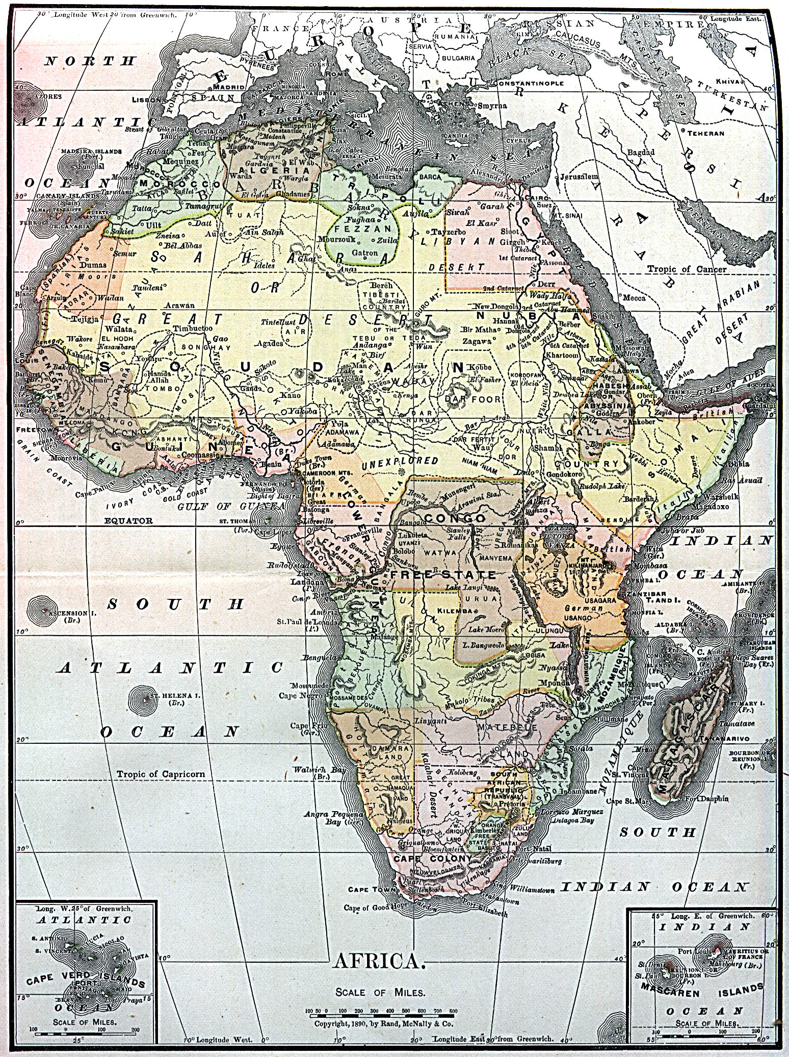
A period piece: map of Africa from 1890

Africa-Map-1890.jpg


http://www.zonu.com/detail3-en/2009-09-17-301/Africa-Map-1890.html
 
Kong Mountains? Somewhere, Alex Richards is preparing himself to war, and when he'll strike it would be too late for all of us.
 
Kong Mountains? Somewhere, Alex Richards is preparing himself to war, and when he'll strike it would be too late for all of us.

The world is fortunate that I'm still in a good mood after getting back from London last night.:p

I wouldn't mind so much if it wasn't for the fact that 1890 is after the expedition which proved that those were completely fictitious (unlike the oft cited 1885 map online). Not to mention that 'Mount Coma' is an even more fictitious addition to the map just to make it look better.

Though based on those native African states in the Sahel I think whoever made it just took an 1860s map and drew some rough colonial borders on it...
 
I'm not entirely sure if this has been fixed in later versions or if I'm just seeing things because of how long I've been staring at the map trying to do something else entirely, but on the Worlda, Tristan da Cunha and Gough Island and the other nearby islands look a little south of where they should be (Tristan da Cunha is at 37.1 S, Gough at 40.3 S; they look on the gridded Worlda to be, blind guess, about 39 S and 42 S).
 
I'm not entirely sure if this has been fixed in later versions or if I'm just seeing things because of how long I've been staring at the map trying to do something else entirely, but on the Worlda, Tristan da Cunha and Gough Island and the other nearby islands look a little south of where they should be (Tristan da Cunha is at 37.1 S, Gough at 40.3 S; they look on the gridded Worlda to be, blind guess, about 39 S and 42 S).

Looking at it, you're right.

Looks like I'm going to have to check to see if I need to completely redraw the Atlantic and Indian oceans as well now. At least it won't take as long as the Pacific did.
 

Huehuecoyotl

Monthly Donor
Anyone happen to know where I might find a map of OTL ca. 1450? I can't seem to find one, even in the old base map threads. :confused: Anywhere in the 1430-1460 span would do the job.
 
I've mapped this list of English market towns from 1722. Key to the colours:

Red - market town
Purple - market town and county town
Pale purple - county town without a market
Green - city
Turquoise - city and county town
Pale green - city without a market

attachment.php
 
Here's something rather ambitious - the basemaps I made for the Swiss election series over in the OTL election maps thread were all made to the same scale (well, most of them were), and I've pasted them all together to form one big editable map of Switzerland. Colour scheme (and basemaps) come from the German Wikipedia user Tschubby, who farts rainbows and shits awesomeness, and deserves all the credit for his work.

communes-ch.png
 
Last edited:

Thande

Donor
Well done Ares. Are you planning to do a stitched-together version of all the results maps, or were the elections at different times?
 
Well done Ares. Are you planning to do a stitched-together version of all the results maps, or were the elections at different times?

They were probably at too different times, but I might do a map of the federal election after that's been, assuming there's easily available data.
 
Top