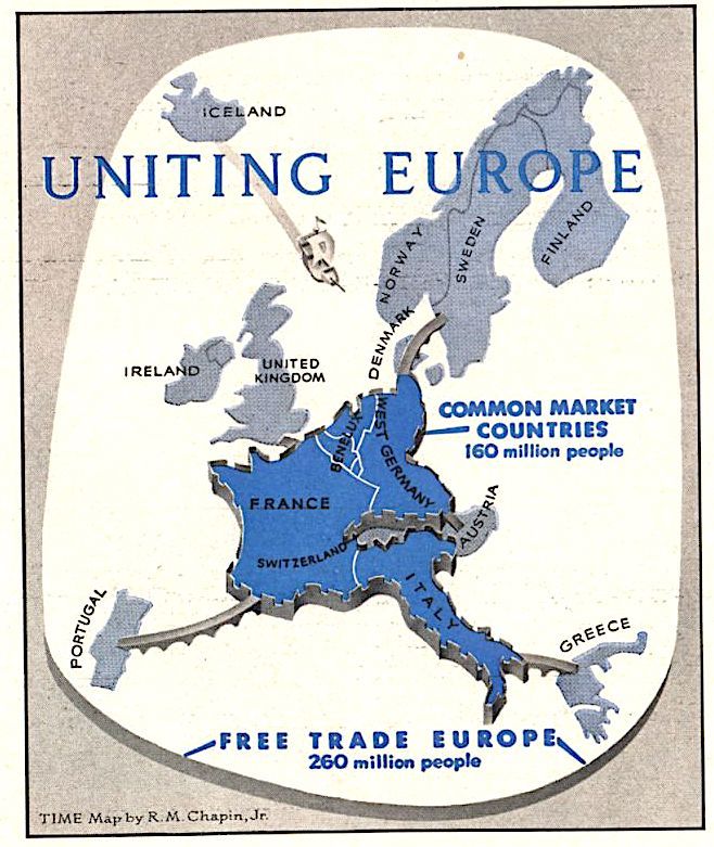
OTL Map Thread Mk IV., 2014-


Places Where Another US State’s Capital is Closer Than Its Own.

by Climatologist49:

Map showing the places where another state’s capital city is closer than its own. This is a revised version of a map I previously submitted (and subsequently deleted) which contained a calculation error. All calculations performed in ArcGIS.

(Source: reddit.com)
 
tumblr_p5pa2aBoee1uo5i21o1_1280.jpg


UNITING EUROPE

Out of the ashes and gutted cities of World War II, idealists tried to create a united Europe by means of a political idea: the Council of Europe. They failed. Then came the hardheaded soldiers and diplomats who wanted to “build Europe” through a European army in a common uniform—and in the ugly, fruitless debate over EDC, all the idealism almost went out of the European dream. Last week, somewhat to their surprise, Europeans found themselves being offered a third chance to build Europe. This time the approach was economic, and, surprisingly enough, the chances were good.

For nearly a year, in a chateau outside Brussels, a small corps of economists, technicians and bureaucrats have been at work to establish a common market (goods and workers moving as freely as between California and New York) among the six nations—France, West Germany, Italy, Belgium, The Netherlands and Luxembourg—which belong to the European Coal and Steel Community. These planners have the backing of every government involved, and they mean business. Their plan calls for:

¶Creating a common market of 160 million people.

¶Cutting tariffs between the six nations by 30% in the next four years, and gradual elimination, over a maximum period of 15 years, of all tariffs and import quotas between them.

¶Establishing, during the same period, common tariffs against outside nations at an average level lower than France’s, higher than the Low Countries’.

¶Abolishing discriminatory transportation charges, such as higher rates for goods originating in another country.

¶Permitting free movement of labor, so that labor-hungry areas such as Germany’s Ruhr can sop up some of Italy’s 2,000,000 unemployed.

¶Permitting free movement of capital, thus making it easier for European industrialists to invest their money where it will be most productive.

¶Equalizing corporate taxes and working conditions. (France, whose cradle-to-grave social security system is the most costly in Europe, is demanding that other nations “harmonize” their welfare systems, overtime rates, etc., with hers.)

TIME, 28 January 1957

The European Common Market was created by the Treaty of Rome, signed on 25 March 1957. This organization eventually provided the basis for the European Union, founded in 1993.
 
tumblr_p628r1CL7d1uo5i21o2_1280.jpg


MIDDLE EAST OIL

THOUGH Britain has populated the Middle East with British political advisers to Arab rulers, and for a time seemed to be running the whole show, in economic fact the region has in recent years been dominated by U.S. companies, who stay out of local politics. They produce about twice as much of the Middle East’s oil as the British. and own nearly 60% of the area’s known reserves. Tiny, treeless Kuwait. the richest producing state in the rich Middle East, is, for example, a sheikdom under British protection and equipped with a British political agent, but its British producing company is half-owned by Gulf Oil (U.S.). Americans also team up with British. Dutch and French interests in Iraq. But Saudi Arabia’s Aramco is entirely an American concession—a syndicate formed by Standard Oil of California, the Texas Co. and Jersey Standard Oil (Esso), plus a smaller share to Socony Mobil Oil.

TIME, 28 January 1957
 
@wtw, you've absolutely violated the 3 images a day limit, and most of the last few pages are full of these maps that you've posted (not made, just found and posted). You really need to tone it down.
 
In the last few days at the mapporn section of reddit maps along the lines of if country XYZ were a TV series have been popping up.


ifpolandwereatvseries.jpg
 
denver-boundaries-1864-1902.png


A map of Denver's boundary changes from the original Congressional incorporation of 1864 right up to 1902, when the city finished a spate of annexations to end up in the familiar "T" shape that it would retain through the elevation to city-county the same year and right up to the 1940s, when state law was changed to let it annex unincorporated areas in bordering counties. However, no further incorporated towns have been annexed since 1902 - including Glendale, which sits right at the lower right corner of the T, and is now surrounded by Denver on all sides.

Source: a map I found at the DPL Western History Collection. It shows all annexations up to the present day, but the post-elevation ones only go down to one shade per decade. It gets genuinely finicky in part, so I probably won't go in that deep. Not now, anyway.
 
Last edited:
Top