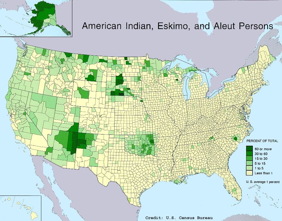
OTL Map Thread Mk IV., 2014-

I find that random bit of South Dakota that was presumably majority Native American at that point more interesting than anything else there really.
It still is.
population_map.gif
 

VT45

Banned
Hey guys, I'm working on a thing! Zoom in for amazing detail; the resolution here is down to 30 arcseconds, translating to one pixel covering 860,556 square meters at the equator. In the end it'll be a Koppen climate map covering the entire planet. Right now I'm putting in the E type climates.

kjGboEy.png
 
That's....

That's quite literally too big to be used as a world map.

It might be useful for very large scale climate maps of individual countries/states what have you however.
 
Hey guys, I'm working on a thing! Zoom in for amazing detail; the resolution here is down to 30 arcseconds, translating to one pixel covering 860,556 square meters at the equator. In the end it'll be a Koppen climate map covering the entire planet. Right now I'm putting in the E type climates.

Interesting. Will you be making a blank map?
 
vf7O4Dw.png

I noticed that there was a worlda topographic map with some missing bits in Alaska, northern Canada, Greenland, Japan and most of Oceania. I never found the complete version and even in the wiki there was only the incomplete version, so I decided to complete it myself by wasting too much time in paint and google images.
Thanks for effort, we should use contributions like this to update the wiki
 
vf7O4Dw.png

I noticed that there was a worlda topographic map with some missing bits in Alaska, northern Canada, Greenland, Japan and most of Oceania. I never found the complete version and even in the wiki there was only the incomplete version, so I decided to complete it myself by wasting too much time in paint and google images.
I don't mean to sound rude, because I very much like your update but it there a reason why there is still a large portion of Greenland and Antarctica left undone? Or do we still not have good enough data to work off of to complete those?
 
The answer depends greatly on whether you can accept ice cap height or want land height. If the latter do you want to factor in the bounce back from the ice cap weight not being present.
 
I don't mean to sound rude, because I very much like your update but it there a reason why there is still a large portion of Greenland and Antarctica left undone? Or do we still not have good enough data to work off of to complete those?
Those are the parts covered by ice. Especially in Greenland's case, the areas covered by ice are under the sea level, and I thought it looked too confusing.
 

VT45

Banned
Scuse the jpg, but I made a thing today!

3QUrxva.png


EDIT: Un-jpg'd it. Now it should be much more easily editable.
 
Last edited:
A thing I just found and finished. The municipalities of New Jersey.

Red = City
Orange = Town
Beige = Borough or Village
Green = Township

new-jersey.png
 
After countless hours correcting borders, updating coastlines, and recoloring countries, I present to you...
Hadaril's Updated OTL Worlda Maps

The majority of my time was spent updating a lot of the older OTL maps to the current blank Worlda, which meant fixing coastlines and fixing country fills accordingly. Additionally, the maps for 1000, 1115, and 1200 got a face-lift by updating them to the current version of the Ancient RCS color scheme. On top of that, the 1500 and 1650 maps were completely redone, as they were in dire need of repair (Wrong Worlda blank map, HRE borders were extremely distorted, especially the french/HRE border and those of Bohemia and Austria) - if you notice any flaws with the new editions, please, please, please let me know. Without further ado, here are the maps.
Note: I was not able to fully update every Worlda map in existence - some were simply too far gone (anyone else remember when we used rectangular base maps? Truly a barbaric era...)

Full Album

Blank and Geological Worlda's
Blank Worlda
Topograhpic Worlda
Climate Worlda

Ancient and Classical Era
1450 BC
1350 BC
600 BC
500 BC
250 BC
44 BC
1 AD

Medieval Era
475 AD
565 AD
710 AD
800 AD
814 AD
843 AD
1000 AD
1115 AD
1200 AD

Early Modern Era
1500 AD
1650 AD

First Revolutionary Era
1776 AD
1789 AD
1812 AD
1815 AD
1861 AD
1885 AD

First World War
1914 AD
1919 AD

Interbellum
1932 AD
1936 AD
1939 AD

Second World War
1940 AD
1941 AD
1942 AD
1943 AD
1944 AD
1945 AD

Cold War Era
1950 AD
1955 AD
1960 AD
1970 AD
1980 AD

New Millenium Era
1990 AD
1995 AD
2000 AD
2001 AD
2005 AD
2010 AD

2nd Revolutionary Era
2014 AD
2016 AD

Cultural Maps
Linguistic Worlda

Timeline Patches
Note: I did not edit or update these patches, but they should work well enough regardless.
Full Imgur Album

Early Chinese Dynasties
Greek and Pheonician Colonies
Persian Empire in 500 BC
Macedonian Empire, 232 BC
Han Dynasty China, 206 BC
Roman Empire, 117 AD
Division of the Empire, 395 AD
Byzantine Empire, 565 - 610
Arab Conquests, 632 - 715
Arab Empire, 717
Al-Andalus, 714 - 970
Byzantine Empire, 1060
Crusader States, 1140
Black Death, 1341 - 1350
Aztec Empire, 1427 - 1520
African States, 1640 - 1830
USA State Claims, 1782 - 1802
Modern China
United States, 1789 - 1819
United States 1820 - 1861
American Civil War, 1861 - 1864
United States, 1870 - 1912
Mexico, 1824 - 1848
Mexico, 1848 - 1974
Australia, 1829 - 1931
Canada, 1867 - 2005
Eastern Front, 1917
South America 1890 - 1998
French W. Africa, 1922 - 1960
Morocco, 1912 - 1972
Persia and Iran, 1893 - 1971
Suez War, 1956 - 1957
Yemen, 1937 - 1990
Iraq War, 2003 - 2009


Credit to all the amazing cartographers out there who have been dedicated to expanding and improving these Worlda maps for years upon years.
 
Last edited:
Top