Long time lurker, first time poster - Took a crack at my first election map, the most recent election for county legislature in Tompkins County, NY. This county in the Finger Lakes region of Upstate New York is notable for its numerous institutions of higher education, especially in the City of Ithaca, home to both Ithaca College and Cornell University. Thanks to this large university presence the county is very heavily Democratic, and it shows in the county legislature. Democrats won 11 of 14 seats to only 3 for the Republicans on the most rural fringes of the county. Of the 11 seats won by Democrats, 6 were unopposed, and of the 5 that were contested, only 1 was contested by a Republican (District 14 in the east, centered on Dryden). Of the 3 districts won by Republicans, only 1 was contested, District 6 in Lansing, which they won by about 8 points (by far the closest race in the county).

You are using an out of date browser. It may not display this or other websites correctly.
You should upgrade or use an alternative browser.
You should upgrade or use an alternative browser.
OTL Election maps resources thread
- Thread starter Thande
- Start date
If you want an upstate county with a landslide legislature, Schenectady only has one republican out of 15 (One Rep, 3 NY Conservatives, and 11 Dems)Long time lurker, first time poster - Took a crack at my first election map, the most recent election for county legislature in Tompkins County, NY. This county in the Finger Lakes region of Upstate New York is notable for its numerous institutions of higher education, especially in the City of Ithaca, home to both Ithaca College and Cornell University. Thanks to this large university presence the county is very heavily Democratic, and it shows in the county legislature. Democrats won 11 of 14 seats to only 3 for the Republicans on the most rural fringes of the county. Of the 11 seats won by Democrats, 6 were unopposed, and of the 5 that were contested, only 1 was contested by a Republican (District 14 in the east, centered on Dryden). Of the 3 districts won by Republicans, only 1 was contested, District 6 in Lansing, which they won by about 8 points (by far the closest race in the county).View attachment 465412
Excuse me I was incorrect 2 Republicans, 3 Conservatives, and 10 DemocratsIf you want an upstate county with a landslide legislature, Schenectady only has one republican out of 15 (One Rep, 3 NY Conservatives, and 11 Dems)
Is there any resource to find province/county/state-level data for the European elections in all member-states? For instance, to make a map with this as the base: https://mapchart.net/europe-nuts2.html
Alex Richards
Donor
Is there any resource to find province/county/state-level data for the European elections in all member-states? For instance, to make a map with this as the base: https://mapchart.net/europe-nuts2.html
For Britain at least you'd have to add up all the individual council areas in each NUTS2 area as that was the counting division used.
I've been doing some Northern Ireland local election maps recently.This necessitated having to make a map for the 1993 to 2011 boundaries, since an editable one didn't actually exist.
Complete sets for every local election are done for the UUP, SDLP and Alliance Party. The maps are by no means one hundred percent accurate, in no small part because I can find no maps whatsoever for the 1973 to 1981 or 1985 to 1989 boundaries. The latter are almost identical to those of 1993 onwards (barring a couple of DEAs added or removed and a restructuring of Newtownabbey), but the 1973 to 81 maps are based mostly on guesswork for me (in that period DEAs didn't even have names, so it's a complete crapshoot as to whether 1981's DEAs A, B and C correspond to 1985's Victoria, Balmoral or Pottinger for instance).
The UUP is also particularly tricky in the earlier elections. In 1973 things were still a little unstandardised (unsurprising given the party was used to complete and utter dominance for half a century, so this whole "actually having to fight competitive elections" thing was a bit new to them). So while many candidates were designated as UUP others were simply "Unionist". Sometimes these were counted in the final tallies as UUP seats but often they weren't (even if, four years later, a lot of them appeared again as UUP candidates). And that's without the other designations such as Non Party or Loyalist that some of them used. For simplicity's sake I am following ARK's lead and the map only shows those seats explicitly tallied as belonging to the UUP. Likewise in 1977 some of the party's candidates stood as joint UUUC/UUP candidates, often up against non-UUUC candidates from their own party. Again, only solely UUP councilors appear on the map.
Sinn Fein, DUP and minor party maps will be along in the near future.
I also have a few sets of maps focusing on last month's local election:
Candidates in the 2019 local elections for all parties by DEA
Gains and losses by the five main parties
Minor party gains and losses
First preference vote of the five main parties by DEA
Party that got the most first preference votes by DEA
Party of candidate that got the most first preference votes by DEA
Increases and decreases in party first preference votes by DEA
Largest party of each designation by DEA, and which designation got the most votes by DEA

Next up, the PvdA. Unlike other social democratic parties in Western Europe, the Labour Party (PvdA) was a newly-created entity in 1946, resulting from the merger of the SDAP, the interwar social democratic party and the VDB, a left-leaning liberal party. By 1967, the PvdA had been out of power for a decade with the exception of the brief Cals government (April 1965-November 1966). The PvdA Prime Minister, Willem Drees (1948-58) had been a very popular figure who, in coalition with the KVP built the Dutch welfare state. By 1967, the party had been going through some electoral decline and as a way to remedy it, it had begun to move towards New Left position to gain over young and female voters. Ultimately this pissed off the party's old guard that split off in 1970 to found the Democratic Socialists 1970 (DS'70), a new party led by Willem Drees Jr.
The PvdA's result in 1967, when it only obtained 37 seats out of 150 was its worse electoral performance until 1994 when it obtained again 37 seats. To this day it's the party's 7th worse performance.

The Catholic People's Party (KVP) was the largest party in 1967, although much of its vote share was concentrated in the two Catholic-majority provinces of North Brabant and Limburg. The party was founded in 1946 as a successor to the Roman Catholic State Party (RKSP) of the interwar period. By 1967, the KVP had been consistently in government since 1945 in centre-left coalitions with the PvdA (1965-66), in centre-right ones with the ARP, CHU and VVD (1958-65, 1966-67) or in centrist ones with both the PvdA, CHU, ARP and/or VVD (1948-58). Internally by this point, the party was divided between two major wings, one closer to the Christian left and progressivism (that would split off in 1968 to found the PPR) and another more traditionally Christian democratic and closer to conservative positions. The 1967 elections represent the beginning of the decline of the Catholic bloc vote, as the KVP went from 30% to 26% of the vote and lost 8 seats.

The PvdA's result in 1967, when it only obtained 37 seats out of 150 was its worse electoral performance until 1994 when it obtained again 37 seats. To this day it's the party's 7th worse performance.
The Catholic People's Party (KVP) was the largest party in 1967, although much of its vote share was concentrated in the two Catholic-majority provinces of North Brabant and Limburg. The party was founded in 1946 as a successor to the Roman Catholic State Party (RKSP) of the interwar period. By 1967, the KVP had been consistently in government since 1945 in centre-left coalitions with the PvdA (1965-66), in centre-right ones with the ARP, CHU and VVD (1958-65, 1966-67) or in centrist ones with both the PvdA, CHU, ARP and/or VVD (1948-58). Internally by this point, the party was divided between two major wings, one closer to the Christian left and progressivism (that would split off in 1968 to found the PPR) and another more traditionally Christian democratic and closer to conservative positions. The 1967 elections represent the beginning of the decline of the Catholic bloc vote, as the KVP went from 30% to 26% of the vote and lost 8 seats.
Non-Hispanic White vote in Texas by precinct:

(grey = no white voters, Trump = red, Clinton = blue)
The five shades of red and blue correspond to wins of 0-20%, 20-40%, 40-60%, 60-80%, 80-100% (from lightest to darkest)
Hmm, this looks like a "spot the urban area" competition.
I can't see the mapNon-Hispanic White vote in Texas by precinct:
(grey = no white voters, Trump = red, Clinton = blue)
The five shades of red and blue correspond to wins of 0-20%, 20-40%, 40-60%, 60-80%, 80-100% (from lightest to darkest)


1920 Tennessee Gubernatorial Election
Representative Alfred A. Taylor (R) 229,133 votes, 54.93% popular vote (+10.37)
Incumbent Governor Albert H. Roberts (D) 185,890 votes, 44.56% popular vote (-10.37%)
Interesting how Shelby and Davidson both went for Roberts, but Knox and Hamilton gave Taylor over 60% of the vote. The coalitions back then were very radically different. And it's also notable how Haywood County, the only majority-black county in the state, was apparently Taylor's best county. That is not surprising, given the Jim Crow conditions which prevailed at the time. Nowadays, Haywood is the only Tennessee county besides Shelby and Davidson that still votes Democratic, because of being black-majority.
1920 Tennessee Gubernatorial Election
Representative Alfred A. Taylor (R) 229,133 votes, 54.93% popular vote (+10.37)
Incumbent Governor Albert H. Roberts (D) 185,890 votes, 44.56% popular vote (-10.37%)
Also, how did you obtain access to this map? Do you have access to the nationwide county map of the 1920 election on Atlas?
Never a 100% sure if this would go here, but in any case. Here's a map of OTL ethnic % of the population in Czechoslovakia according to the 1930 census, the last one before WWII.
Note: Here Jewish means people who identified as Jewish in ethnic terms, not religious ones. Foe that reason many Jews in Bohemia and Moravia identified as either Czechoslovak or German. In any case, a map of the breakdown of each major ethnic group will follow suit as well as one with the main religious groups.
Also, the map in Bohemia and Moravia uses the administrative districts for the purpose of homogeneity, however, I also have data and maps to draw the judicial districts (smaller units, typically any admin. district had from 1 to 4).

Mapping the closely watched special election from last night. Final figures might move around slightly, pending certification, but it should look basically like this. I used the wikipedia template, otherwise I would have just done margins, though the third party voteshare was rather negligible so I guess it doesn't matter too much.
Amusingly, Republican Dan Bishop's home county is that portion of Mecklenburg, the only part of the district to swing against him.
Last edited:
Religions' map of Czechoslovakia, according to the 1930 census.
Religious adherence to the Catholic Church in Bohemia was very weak, even among self-professed Catholics. Even for devout Catholics and even in Moravia, Czech national culture was deeply tied to the Hussite heresy, and Jan Hus was revered as a father of the nation, regardless of his religious inclinations. As such, over the 1920s and 1930s, more and more Czechs would move away from the Church towards the newly-created Czechoslovak Church, various Neo-Hussite groups are identify as 'non-religious'.
Needless to say, relations between the Church and the Czechoslovak state were not easy in the beginning, given the anti-clerical or secular predilections of the main Czech parties (with the exception of the Czechoslovak People's Party) and their idolization of the Hussite movement. As a result, relations were very tense, although the state was not laïque or officially secular due to opposition from the CSL and the Slovak People's Party during the constitutional drafting period. In 1928, Benes and the papal Nunzio signed a 'modus vivendi', short of a concordat but a decent enough agreement to normalize relations.
The Czechoslovak Church is an interesting thing. It was founded in 1919 as a splinter of the Catholic Church. Originally a sort of modernist Catholic Church, advocating lay participation in rituals, the use of Czech in the liturgy and the Bible, the Church would also soon come to adopt elements drawn from Hussite tradition, other Protestant traditions and even Orthodoxy. The Czechoslovak Church was sort of the 'national' church in a way, as it was very closely linked to people like Masaryk or Benes, among other major politicians of the First Czechoslovak Republic. The Czechoslovak Church was, despite its name, a Czech and especially Bohemian phenomenon.
The Augsburg Confession churches (for there were 2, the Silesian one, mostly Polish, and the Slovakia and Subcarpathian Ruthenia) were Lutheran churches. The Reformed Church of Czechoslovakia was a Calvinist church, mostly ethnically Hungarian, and a splinter of the Hungarian Reformed Church.
About Jews, whereas Jews in Bohemia and Moravia as well as a good chunk of Slovakia belonged to the more secular, reformist strands, the Jews of eastern Slovakia and especially in the Subcarpathian Rus where Hassidic jews, and many times actively hostile to the work/presence of Zionists and secularized Jews. Many of them had crossed the Carpathian Mountains in the 17th and 18th centuries from Poland or Russia.
Rusyns were predominantly Greek Orthodox with a significant minority of 'Russian' Orthodox. Many Greek Catholic priests had enjoyed good relations with the pre-1920 Hungarian state, and as such as the Greek Catholic hierarchy was very suspected of being Magyarones (pro-Hungarian fifth column). For that reason, the Czechoslovak state encouraged people to become Orthodox. That went as far as having the Czechoslovak state organize the Eparchy of Mukacevo and Presov, attached to the Serbian Orthodox Church, due to historical ties and the fact that Russia and Ukraine were communist states. This was also supposed to help the Ukrainophile and Russophile elements of the Rusyn nationalist elites and help them reach the people of the region, at the time very backwards.
Is this an OTL map or is it from some Alternate T/L?Religions' map of Czechoslovakia, according to the 1930 census.
Religious adherence to the Catholic Church in Bohemia was very weak, even among self-professed Catholics. Even for devout Catholics and even in Moravia, Czech national culture was deeply tied to the Hussite heresy, and Jan Hus was revered as a father of the nation, regardless of his religious inclinations. As such, over the 1920s and 1930s, more and more Czechs would move away from the Church towards the newly-created Czechoslovak Church, various Neo-Hussite groups are identify as 'non-religious'.
Needless to say, relations between the Church and the Czechoslovak state were not easy in the beginning, given the anti-clerical or secular predilections of the main Czech parties (with the exception of the Czechoslovak People's Party) and their idolization of the Hussite movement. As a result, relations were very tense, although the state was not laïque or officially secular due to opposition from the CSL and the Slovak People's Party during the constitutional drafting period. In 1928, Benes and the papal Nunzio signed a 'modus vivendi', short of a concordat but a decent enough agreement to normalize relations.
The Czechoslovak Church is an interesting thing. It was founded in 1919 as a splinter of the Catholic Church. Originally a sort of modernist Catholic Church, advocating lay participation in rituals, the use of Czech in the liturgy and the Bible, the Church would also soon come to adopt elements drawn from Hussite tradition, other Protestant traditions and even Orthodoxy. The Czechoslovak Church was sort of the 'national' church in a way, as it was very closely linked to people like Masaryk or Benes, among other major politicians of the First Czechoslovak Republic. The Czechoslovak Church was, despite its name, a Czech and especially Bohemian phenomenon.
The Augsburg Confession churches (for there were 2, the Silesian one, mostly Polish, and the Slovakia and Subcarpathian Ruthenia) were Lutheran churches. The Reformed Church of Czechoslovakia was a Calvinist church, mostly ethnically Hungarian, and a splinter of the Hungarian Reformed Church.
About Jews, whereas Jews in Bohemia and Moravia as well as a good chunk of Slovakia belonged to the more secular, reformist strands, the Jews of eastern Slovakia and especially in the Subcarpathian Rus where Hassidic jews, and many times actively hostile to the work/presence of Zionists and secularized Jews. Many of them had crossed the Carpathian Mountains in the 17th and 18th centuries from Poland or Russia.
Rusyns were predominantly Greek Orthodox with a significant minority of 'Russian' Orthodox. Many Greek Catholic priests had enjoyed good relations with the pre-1920 Hungarian state, and as such as the Greek Catholic hierarchy was very suspected of being Magyarones (pro-Hungarian fifth column). For that reason, the Czechoslovak state encouraged people to become Orthodox. That went as far as having the Czechoslovak state organize the Eparchy of Mukacevo and Presov, attached to the Serbian Orthodox Church, due to historical ties and the fact that Russia and Ukraine were communist states. This was also supposed to help the Ukrainophile and Russophile elements of the Rusyn nationalist elites and help them reach the people of the region, at the time very backwards.
If it is the latter, this is the wrong thread.
Interesting how Shelby and Davidson both went for Roberts, but Knox and Hamilton gave Taylor over 60% of the vote. The coalitions back then were very radically different. And it's also notable how Haywood County, the only majority-black county in the state, was apparently Taylor's best county. That is not surprising, given the Jim Crow conditions which prevailed at the time. Nowadays, Haywood is the only Tennessee county besides Shelby and Davidson that still votes Democratic, because of being black-majority.
Also, how did you obtain access to this map? Do you have access to the nationwide county map of the 1920 election on Atlas?
I got the results from OurCampaigns.org, they have county maps for a bunch of older statewide elections.
I do not have access to the 1920 Presidential results, other than those that are also available on Our Campaigns.
Alex Richards
Donor
Is this an OTL map or is it from some Alternate T/L?
If it is the latter, this is the wrong thread.
Having seen it cross-posted elsewhere, it's OTL.
2016 Presidential Election in Missouri by Precinct:
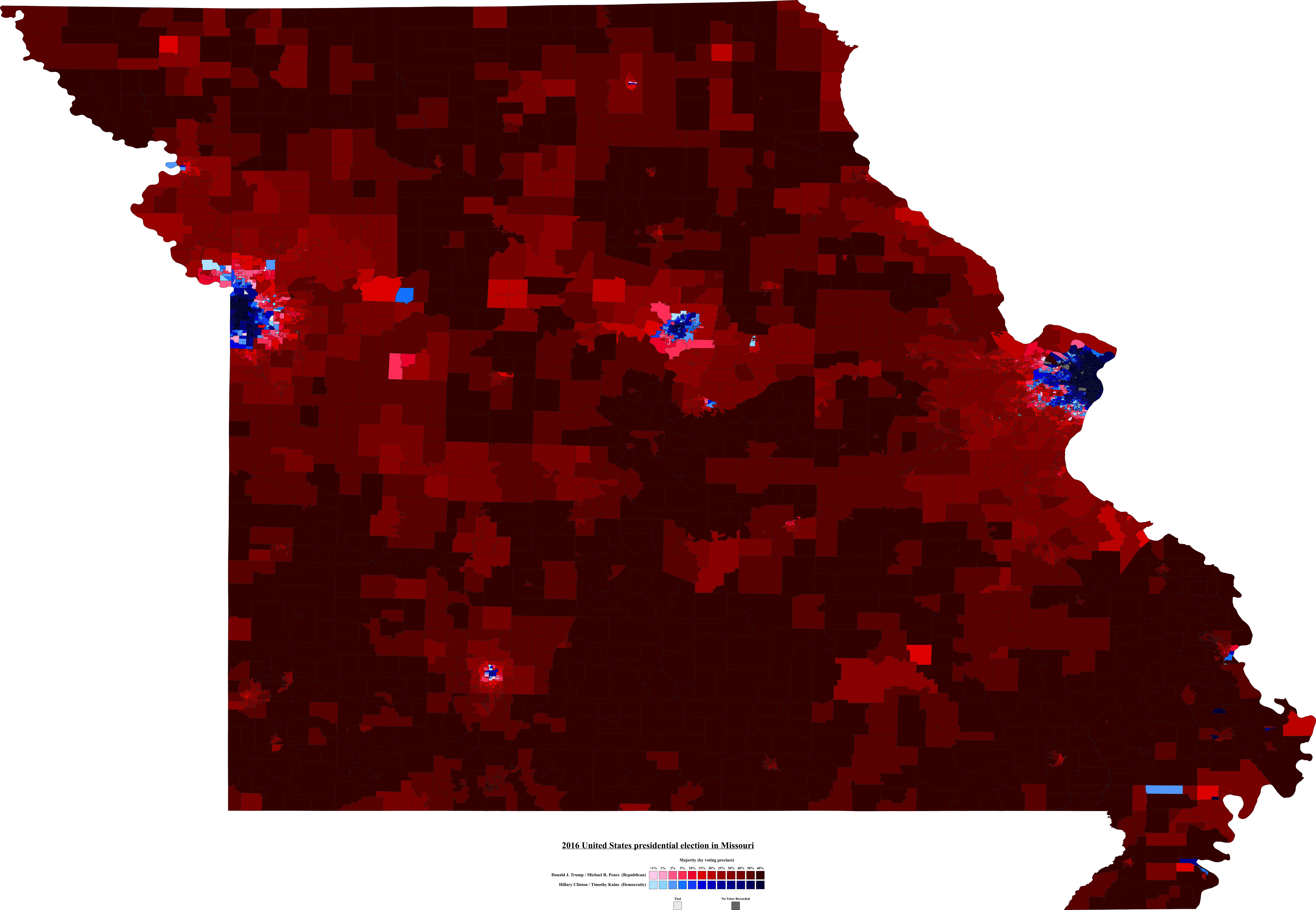
(I have maps for the statewide offices and Senate election from 2016 as well - those will be uploaded gradually)
Let's play a game of "spot the urban centres". No prizes for guessing where they are.
Share: