OTL Election maps resources thread

Thande

Donor
Toronto actually used to have slightly more compact ridings, as per below:

Toronto_Ridings_-_1904.PNG

(federal)

1914TorontoRidings.jpg

(provincial)

Can't really say why they changed, but Occam's razor says they got lazy and decided to just slice the city up into roughly equally populated strips of land.
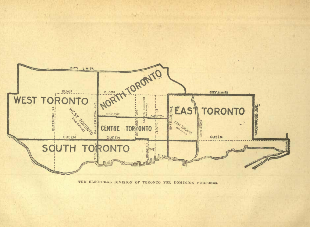
Huh, you're right - so Ontario had normal-looking ridings in 1867 but deliberately decided to switch to looooong Quebec-style ones later. Because Canada, presumably.

640px-Canadian_federal_election%2C_1867_Results_Map.svg.png
 
In the 2017 Republican primaries for Virginia governor, State Senator Frank Wagner ended up getting third place in the primary (and didn't win any counties) behind Corey Stewart and Ed Gillespie. Frank Wagner ended up getting 13.8% of the GOP primary vote.

I decided to make a small map illustrating which areas he got the most support. As my map shows, Wagner ended up getting the most support in the so-called "Tidewater Counties" in Virginia, and did best in Virginia Beach county.

frank_wagner_virginia_2016.png
 
Last day of the year, last election under a two-round system. Or the last one I'll map, anyway. Here's 1913.

The left won back a small majority and a progressive, social liberal cabinet took office. This cabinet was responsible keeping the Netherlands out of World War I, introducing income tax and making plans for the Zuiderzee Works. Most relevant for me, however, is its constitutional amendment that would introduce universal male suffrage and party-list proportional representation in one nation-wide constituency. In order to win over the Christian democratic right's support, the new constitution would also ensure equal financing of religious school, thus ending the school struggle that had defined politics for so long. Since a constitutional amendment required the approval of two successive parliaments, the election in 1917 was mostly ceremonial, with the major parties not fielding candidates in other parties' seats. That's why I won't map it and go straight to the 1918 one next year.

XBHEzET.png


@Oliver, you are officially awesome. :cool:

Here's a preview of my attempt to live up to expectations.

xWiQvYp.png
 
That's awesome work there.

Come to think of it, is it possible for you to create a data-dump for where you're getting all of this from? It occurs to me that others would probably be happy to assist with adding majority shading/party voteshare heat maps for various years as and when they have time.
 
You can really tell what schools are in the top level as public research universities and private liberal arts schools vs religious private colleges !
 
Washington University St Louis is more blue then D.C. !


QUOTE="Reagent, post: 16264660, member: 71534"]Another "resource" rather than a map, but:

missouri_universities_by_reagentah-dby65wz.png


Exit Polls indicated that Trump won 18-29 year olds in Missouri by 11%. Not entirely sure how much this supports that finding, but there seems to be enough variance to indicate that at least in a number of universities, Trump managed to win the student vote here (which of course, is to say nothing of the voting habits of those who don't attend university (which is still over half of that age demo, even if that figure decreases each year).[/QUOTE]
 
That's magnificent. My one quibble is that I would've put Zentrum in gray and the DNVP in blue, but I can see how that would make the colour scheme confusing.
 
have a gift of sorts
unknown.png

i was tired of having to go hunting for colours every time i got bored and made an election map so i compiled all the AJR colour gradients into one image

edit: in case it's not clear, brown and teal are at the bottom because they're usually used as independent and other respectively
 
Last edited:
have a gift of sorts
unknown.png

i was tired of having to go hunting for colours every time i got bored and made an election map so i compiled all the AJR colour gradients into one image
AAAAAAAAAAAAAAAAAAAAAAAAAAAAAAAAAAAAAAAAAAAAAAAAAA


Now, I can be exactly 62.5% more pedantic with my party designations.
 

Thande

Donor
have a gift of sorts
unknown.png

i was tired of having to go hunting for colours every time i got bored and made an election map so i compiled all the AJR colour gradients into one image
Thanks. Who came up with that unopposed colour for the grey scale? I get what they were going for, but it seems too easy to mistake for one of the pale teal shades.
 
Thanks. Who came up with that unopposed colour for the grey scale? I get what they were going for, but it seems too easy to mistake for one of the pale teal shades.
I filled in a few of the blanks, including that. I'm not happy with it either - it was either that or a shade of plain grey. If you have another idea I'd love to hear it :V
 
Top