A few days ago I started trying my hand at making maps in Districtr. My present goals are to make districts with compact shapes, and to avoid splitting up cities more than I need to. Is there a map program that clearly demarcates city borders? If so, I might switch to that program. In some states, I’m dabbling with multiple-member districts. When I get better at this, I’ll see if I can give underrepresented ethnicities their own districts without giving republicans an unfair advantage.
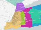
Without much further ado, here is my map of Minnesota! I zoomed in on the south half of the state so you can make out all the borders.
In Minnesota, the partisan balance turned out to be 2 republican, 6 democrat, with the North District being democrat. That was an interesting surprise.
I started by splitting the state in two, with 50% of the people in the Metro area excluding some of the outer suburbs, and 50% everywhere else. Then I marked out the north as a district, and fit Minneapolis and most of St. Paul in another. Then I drew the rest of the places.
I'd like to get the St. Cloud - Buffalo District, to include more of the places just west of St. Cloud and Buffalo. I want to avoid having the biggest city in the district being , and probably the western tip of the Metro that's in Blue District. If I do that, I'd have to change Blue District and North District, and I'd want to be careful not to divide the surprisingly dense Crow Wing County while I'm at it. Crow Wing County is where Brainerd is.
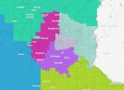
You'll see that South Metro District (in purple) has a town dangling from it. My strategy involved getting as much city as I can and as little country as I can in the Twin Cities, which has led to that. The East Metro District has the most country of the metro districts, since it's filling in the Wisconsin border. I was open to the idea of putting the border in a nonmetro district if the math worked out, but the math worked better this way.
I’m really happy with how the Rochester District turned out. My only problem is that I ended up with a town dangling from the west end of the district.
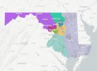
Coming up next time, Maryland! I discovered making compact districts in that weird-shaped state was actually super-easy. But it had other problems. You’ll have to wait and see.
Without much further ado, here is my map of Minnesota! I zoomed in on the south half of the state so you can make out all the borders.
In Minnesota, the partisan balance turned out to be 2 republican, 6 democrat, with the North District being democrat. That was an interesting surprise.
I started by splitting the state in two, with 50% of the people in the Metro area excluding some of the outer suburbs, and 50% everywhere else. Then I marked out the north as a district, and fit Minneapolis and most of St. Paul in another. Then I drew the rest of the places.
I'd like to get the St. Cloud - Buffalo District, to include more of the places just west of St. Cloud and Buffalo. I want to avoid having the biggest city in the district being , and probably the western tip of the Metro that's in Blue District. If I do that, I'd have to change Blue District and North District, and I'd want to be careful not to divide the surprisingly dense Crow Wing County while I'm at it. Crow Wing County is where Brainerd is.
You'll see that South Metro District (in purple) has a town dangling from it. My strategy involved getting as much city as I can and as little country as I can in the Twin Cities, which has led to that. The East Metro District has the most country of the metro districts, since it's filling in the Wisconsin border. I was open to the idea of putting the border in a nonmetro district if the math worked out, but the math worked better this way.
I’m really happy with how the Rochester District turned out. My only problem is that I ended up with a town dangling from the west end of the district.
Coming up next time, Maryland! I discovered making compact districts in that weird-shaped state was actually super-easy. But it had other problems. You’ll have to wait and see.
Attachments
Last edited: