MotF 140: Divide and Conquer

MotF 140: Divide and Conquer

The Challenge
Make a map showing an alternate distribution of land after a conflict (EDIT: or land dispute) with the same victors as OTL. Examples would include a different division of Germany after WWI, or an alternate Reconstruction period after the Civil War.

The Restrictions
There are no restrictions on when your PoD or map may be set. Fantasy, sci-fi, and future maps are allowed, but blatantly implausible (ASB) maps are not.

If you're not sure whether your idea meets the criteria of this challenge, please feel free to PM me.

Please try to keep images posted in this thread a reasonable size - feel free to post a smaller version of your image and provide link to a full-size version if you want to.


---

The entry period for this round shall end when the voting thread is posted on Sunday the 10th of July.

---

THIS THREAD IS FOR ENTRIES ONLY.

Any discussion must take place in the main thread. If you post anything other than a map entry (or a description accompanying a map entry) in this thread then you will be asked to delete the post. If you refuse to delete the post, post something that is clearly disruptive or malicious, or post spam then you may be disqualified from entering in this round of MotF and you may be reported to the board's moderators.

Remember to vote on the previous round of MotF!
 
Last edited:
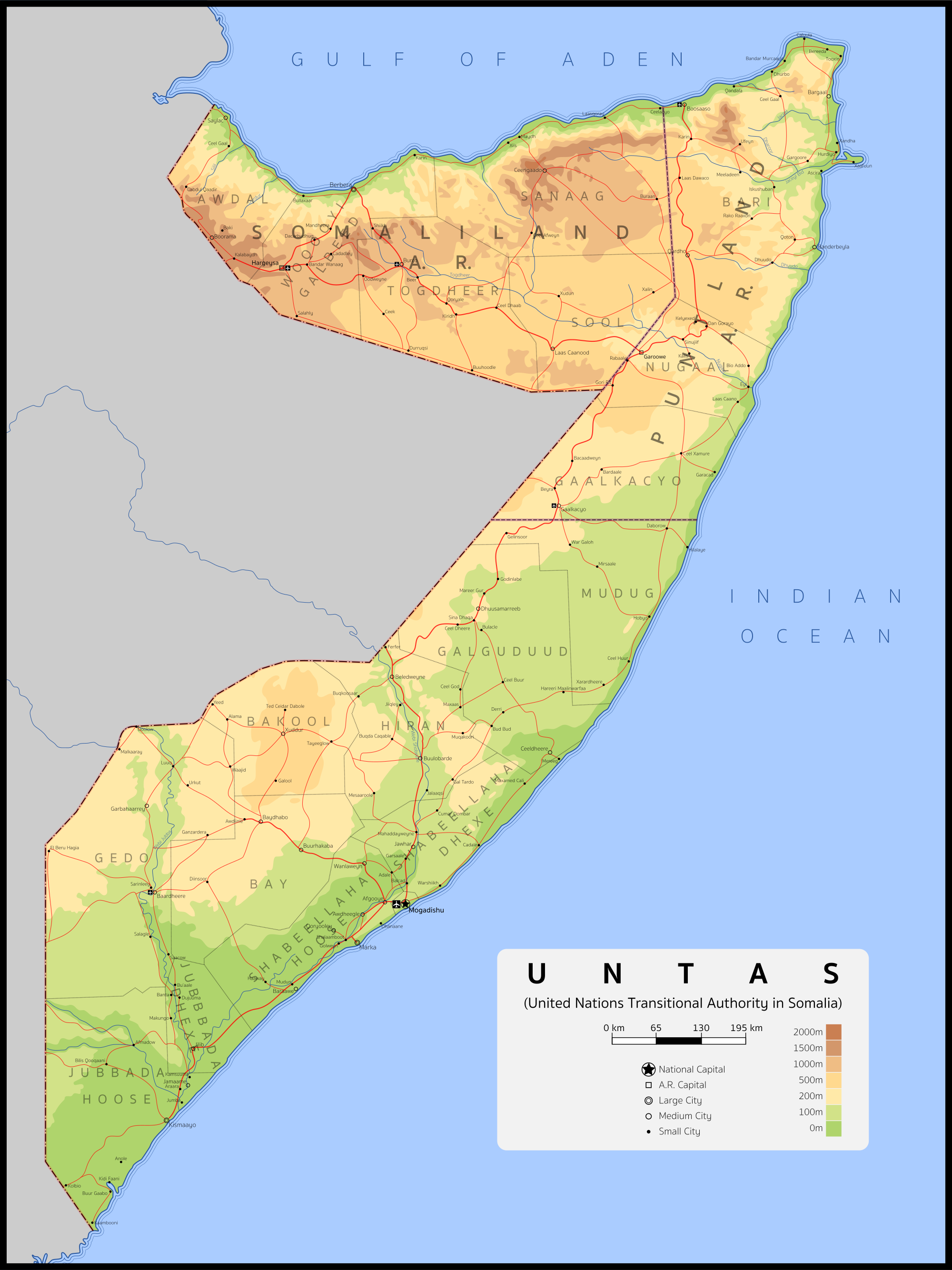
United Nations Transitional Authority in Somalia

united_nations_transitional_authority_in_somalia_by_zeksora-da99eml.png

I thought that since UNOSOM II (United Nations Operation in Somalia II) was generally regarded as a success, it met the standards of the prompt. This version of UNOSOM II is much more successful, as President Clinton doesn't unilaterally pull out U.S. forces, and the Security Council decides to implement a Transitional Authority under U.N. governance in Somalia, similarly to how Transitional Authorities had been implemented in Cambodia and East Timor IOTL. There honestly isn't much else to TTL that I've thought out (what knowledge I have of Somalia I got while researching for this map), so have an infobox:

spmup8f.png
 
The POD for this scenario is that the Yugoslav Chetniks are an actual competent anti-fascist resistance movement instead of mostly collaborating with the Axis. Although they are firmly anti-communist, they manage to generally collaborate with Tito’s Partisans for most of the war, and they are given much support from the British. The presence of a large pro-British organization increases British support for Churchill’s idea of invading the Balkans, and much of the British forces that would have been used in Italy instead land in Greece, Albania, and Dalmatia. Axis forces are transferred from central Europe to fight the British in the Balkans, but they are defeated. As the Axis retreats from the Balkans, the Chetniks and Partisans begin fighting each other. Meanwhile, Italy holds out longer because the allied invasion force is smaller. To the north, the Red army advances through central Europe slightly faster because there are fewer Axis forces there, and by the end of the war they have reached Salzburg and Venice.

After the war, Austria is occupied entirely by the Soviet Union, and Italy is divided between French, Soviet, American, and British occupation zones. The Soviet-supported Partisans and British-supported Chetniks continue to fight in Yugoslavia for a few months until an armistice and division between north and south is agreed to. While North Yugoslavia holds together under Tito, the government of South Yugoslavia is weak. As many parts of South Yugoslavia declare independence, a ‘Balkan Confederation’ is proposed between the former South Yugoslavian nations and Albania and Bulgaria, which are not communist because they are British instead of Soviet influenced, to prevent the new small Balkan states falling under Soviet domination. This is mostly a loose confederation, but with a fully united military. The Balkan Confederation is created.

Click image for full size
alternate WWII balkans small.png
 
The Ukraine War (February 1919 – May 1922) was an armed conflict that pitted Soviet Russia against the united forces of the Second Polish Republic and the Ukrainian People's Republic.

The conflict began when the Polish head of state Józef Piłsudski formed an alliance with the Ukrainian nationalist leader Symon Petlyura and their combined forces invaded Soviet-occupied Ukraine, liberating Kiev on May 7. In June the Soviet Red Army launched a counteroffensive, reaching the former Polish border by the end of July and advancing through Poland to the outskirts of Warsaw by early August. After a series of battles the Polish-Ukrainian forces managed to inflict a rout on Soviet forces (see 'Miracle on the Vistula') and began to drive the Soviet forces back.

The first peace negotiations began as early as October 1920, but broke down as the Soviets were unwilling to concede key Polish-Ukrainian requirements. The war continued until August 1921, when the allied forces had reached as far as Kharkiv (Kharkov) and Vitebsk, and the Soviet government agreed to an armistice.

The Treaty of Minsk, concluded on May 3, 1922, provided for the bulk of Ukraine to remain an independent state and for substantial portions of Byelorussia to be ceded to Poland, although the eastern parts of both regions remained part of the Soviet Union and became the Byelorussian SSR and Ukrainian ASSR, respectively. The treaty established the frontiers between Poland, Ukraine, and Russia until 1941.


ikZPVaL.jpg
 
Vermont has a unique feature in its history, namely that it is one of the only states in the country to have been a sovereign nation at one point. The state was admitted in 1791, as the first state not to be one of the thirteen colonies, after New York conceded its claims to the region. Vermont's roots start in the New Hampshire Grants, which Governor Benning Wentworth gave out for settling the region. The region's militia, the Green Mountain Boys, resisted New York's claims to the region, and they eventually proclaimed the Vermont Republic in 1777. Despite Vermont's wishes to join the union, it was kept out until New York conceded its claims for 30 thousand dollars. In this scenario, New York does not give up its claims, and Vermont ends up being subject to a partition to "join" the Union. The land ended up being split between New Hampshire, New York, and Massachusetts (under the guise of "mediator"), with the former getting most of the land, as a large part of the land had been settled under the "New Hampshire Grants". New York got a slice of west-central Vermont, and Massachusetts got the southern end (including Bennington).

Presently, the geography of the "Lands of the Green Mountains" (an uncommon name referring to the region, which barely exists in most Americans' minds) is quite fascinating. To someone from OTL, hypothetically traveling through Vermont would be very fascinating. For starters, most of the towns have names that are not found in OTL Vermont, and in the case of a few (e.g. Berlin, NH), they take a name from a town that already existed in the OTL state (in the case of the "real" Berlin, ITTL it is called by its original name Maynesborough) The Massachusetts and New York parts are mostly exurban towns, anchored by Bennington, Massachusetts (a small city ITTL). The northwest, along Lake Champlain, is home to both the metropolis of Burlington and sleepy lakeside villages. Most towns in the northeastern end are the result of "settlement plantations", set up by New Hampshire in the 19th century to attract settlers from Massachusetts and Connecticut, and as a result most of them are named after communities from those two states. To most people of the region ITTL, the name Vermont refers to a county in the New Hampshire area of the former territory. There is little to no support for statehood for *Vermont, and its popularity is akin to OTL's Second Vermont Republic- people dismiss it as implausible and bad for the economy. In terms of population, the area is more populated (about 950,000 people), largely due to the fact that the states *Vermont is part of had/have more people and money than OTL Vermont, allotting more funds for the region.

zLdRlL8.jpg
 
Last edited:
Screen Shot 2016-07-11 at 2.59.09 PM.png


Full Map Here


Work in Progress....

The POD for this map centers around the early 1770's, when the American Revolution begins to boil over. The British increase taxes for the 13 colonies, as well as those nearby, such as Nova Scotia (sometimes considered the '14th colony'), Newfoundland, and Quebec, to proactively ensure that they stayed in line. As the revolution started to heat up, the 13 colonies were able to rally patriot sympathies, leading to several of the other colonies revolting, and cutting off some of Britain's naval power. The Battle of Quebec in 1775 succeeded due to the support of the French Canadians, who were frustrated of the tyrannic rule of George III. By the time that the French and Spanish join the war, the Americans are able to rout the British. The magnitude of this defeat was felt when the Treaty of Paris was signed by representatives of each country, granting the Americans their freedom and all British territory east of the Mississippi River and south of Lake Michigan. The French were granted lands along the St. Lawrence River where many French Canadians still resided. As part of the restored Quebec, the French were granted part of the 'Northwest Territory' adjacent to Quebec as well. The American delegation was in favor of the 'Restoration of Quebec' because it provided a buffer between them and the remnants of British North America.

History progresses similarly to OTL. Between 1803 and 1805, diplomats negotiated the sale of the Louisiana Territory to the United States. Napoleon strongly considered retaining control of the territory, hoping that it could become another Quebec, but with the revolt of Saint-Domongue and the possibility of war with the United Kingdom, it was decided that it would be more beneficial to sell the territory instead. There was a much milder War of 1812 between the Americans and the British, which ended quickly with a stalemate. The Mexican American War, fought from 1845 to 1847, ends similarly, with the United States acquiring a large amount of territory in the Mexican Cession (though not as much as OTL). The Oregon Treaty of 1848 determined the borders of the American Northwest with British Canada.

The map is from 1856, before the beginning of the First American Servile Insurrection. It shows the various steamer routes between Britain, Europe, the United States, Quebec, and British America. Also shown is the first Atlantic Telegraph Cable, which provided a faster means of communication between the two continents.
 
Last edited:
Top