Map Thread XXI

Status
Not open for further replies.
Funny idea, but why go with ugly post 1918/45 borders?

With Austria taken, who could you unite Germany with in somewhat equal terms?
Netherland? /not sure if on "equal therms", but theres probably better chance to it, than with Austria)
Or, if we are going more on equality, then probably Franco-German union/confederation?
Italy and Spain, which @DracoLazarus suggest unite with France, could be then united together...
 
Funny idea, but why go with ugly post 1918/45 borders?


Netherland? /not sure if on "equal therms", but theres probably better chance to it, than with Austria)
Or, if we are going more on equality, then probably Franco-German union/confederation?
obviously, Britain-Hanover expands into Britain-Germany (have to drop Northern Ireland to keep it dual rather than triple, but that's no great sacrifice. :biggrin: )
 
Well, following my tradition of doing anything but the maps I told people I'd do, here's a cover of an old map by Thande, in which the US apparently takes Canada in the Revolution and the UK responds by going apeshit on the rest of the world. :biggrin:

Admittedly, I've changed some stuff up, but I think it's still close enough to qualify as a "cover."

(I'm assuming PODs originally in the 18th century, because, really [1])

FalseNorth.PNG


[1] The original

ThandeContinentalRepublic.gif
 
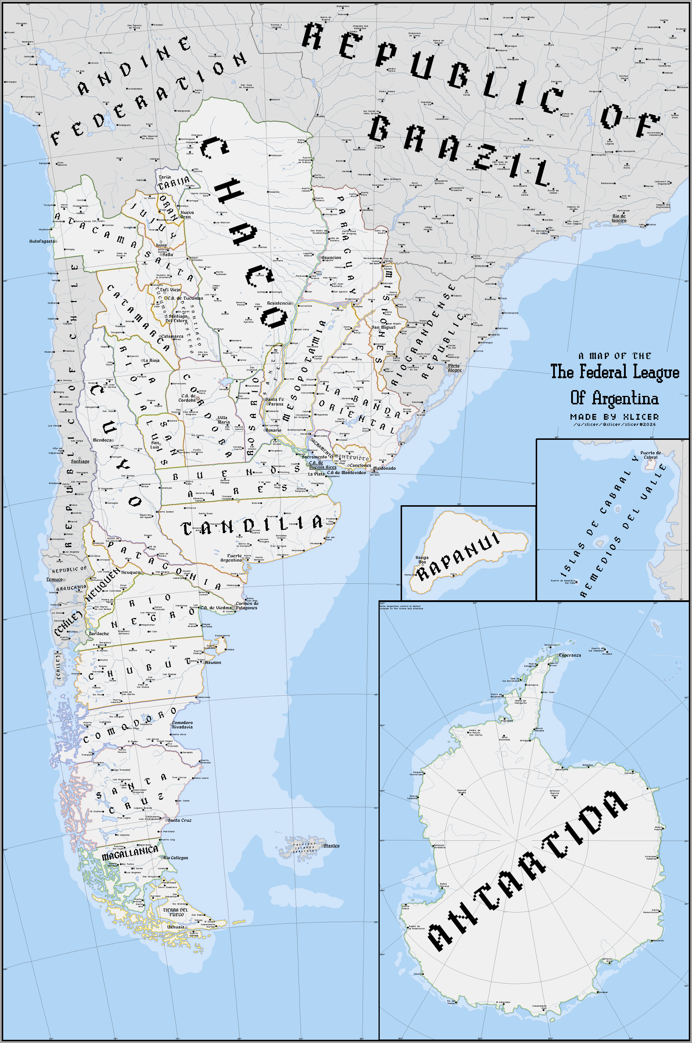
What if Argentina developed similarly to the USA? - The Federal League of Argentina

dfjhhvl-9f33518d-5e13-4db0-961b-93429f026418.png


Deviantart link

Hi alternatehistory.com . This is a map that I made while testing creating maps entirely using mobile apps, basically Medibang but also Ibis Paint X for the text. I made it about Argentina since creating maps of "what if my country was big" can be fun sometimes. And yes, I have explanations for a bunch of the decisions that I took regarding borders, so really feel free to ask. Credits where are due, style stolen shamefully inspired by National Cartographic-The United States of America by theaidanman as I wanted to create something with a national geographic like-style for a while, and that map seemed perfect style wise.

I hope you all like it!
 
712E17A3-B6D9-401C-80D5-15825FDBC5AB.jpeg


All countries who participated in the FIFA 1930 World Cup are ISOTed to a virgin earth (colonies included).

This is part of a series i’m working on about the World Cup. I might have gotten a few historical errors, though.
 
Heaven is not so picky - the 10 Great Dynasties of China
pdHAnmk.png
In which Poland and Iberia are both integral parts of China since Ancient Times™️.

But really though, that’s an interestingly high number of conquest dynasties. Turks, Tibetans, Koreans, Vietnamese, Japanese, Poles/Portuguese, followed by the French. That’s a China that’s been ruled by the non-Han more than they’ve ever been ruled by a Han Chinese dynasty.

Two questions, the Vietnamese Sheng dynasty seems to have ruled the longest, how sinified has Vietnam become as a result?

And how does the Sinitic Union’s elective monarchy work? Is it like the one Malaysia has, where there’s a set number of regional monarchs and the big hat rotates between that group, or is it like the UAE where the top monarch is ‘elected’ but the result is always the same? Or is it like the US presidency where the ‘monarch’ bit doesn’t actually confer any of the usual royal privileges?
 
What if Argentina developed similarly to the USA? - The Federal League of Argentina

dfjhhvl-9f33518d-5e13-4db0-961b-93429f026418.png


Deviantart link

Hi alternatehistory.com . This is a map that I made while testing creating maps entirely using mobile apps, basically Medibang but also Ibis Paint X for the text. I made it about Argentina since creating maps of "what if my country was big" can be fun sometimes. And yes, I have explanations for a bunch of the decisions that I took regarding borders, so really feel free to ask. Credits where are due, style stolen shamefully inspired by National Cartographic-The United States of America by theaidanman as I wanted to create something with a national geographic like-style for a while, and that map seemed perfect style wise.

I hope you all like it!
It's amazing but also the pixel text kills me inside
 
Heaven is not so picky - the 10 Great Dynasties of China
The number of non-Han dynasties including European Colonial and Japanese dynasties who simply declared themselves a new dynasty makes me wonder if would-be colonial administrators including the Japanese ever considered declaring their King as Emperor of China? I mean Queen Victoria declared herself Empress of India as part of the dissolution of the last remnants of the Mughal kings
 
What if Argentina developed similarly to the USA? - The Federal League of Argentina

dfjhhvl-9f33518d-5e13-4db0-961b-93429f026418.png


Deviantart link

Hi alternatehistory.com . This is a map that I made while testing creating maps entirely using mobile apps, basically Medibang but also Ibis Paint X for the text. I made it about Argentina since creating maps of "what if my country was big" can be fun sometimes. And yes, I have explanations for a bunch of the decisions that I took regarding borders, so really feel free to ask. Credits where are due, style stolen shamefully inspired by National Cartographic-The United States of America by theaidanman as I wanted to create something with a national geographic like-style for a while, and that map seemed perfect style wise.

I hope you all like it!
Very.....interesting subdivisions. A tiny nitpick I have is that the font when it's big looks a bit weird compared to pixel perfect everything of the map, but everything else I love it!
 
It's amazing but also the pixel text kills me inside
I see, I went for the pixelated aesthetic since I found it most fitting for the low resolution of the mobile canvas and to compliment with the 1px coastlines and borders, nut I can see why for some it may not be their cup of tea.
 
Very.....interesting subdivisions. A tiny nitpick I have is that the font when it's big looks a bit weird compared to pixel perfect everything of the map, but everything else I love it!
Basically I had to re draw the big text every time I wanted it to be in an angle. A lot was just me testing things on apps I was not 100% familiar with them.
 
What if Argentina developed similarly to the USA? - The Federal League of Argentina

dfjhhvl-9f33518d-5e13-4db0-961b-93429f026418.png


Deviantart link

Hi alternatehistory.com . This is a map that I made while testing creating maps entirely using mobile apps, basically Medibang but also Ibis Paint X for the text. I made it about Argentina since creating maps of "what if my country was big" can be fun sometimes. And yes, I have explanations for a bunch of the decisions that I took regarding borders, so really feel free to ask. Credits where are due, style stolen shamefully inspired by National Cartographic-The United States of America by theaidanman as I wanted to create something with a national geographic like-style for a while, and that map seemed perfect style wise.

I hope you all like it!
Even Big Argentina is not allowed to have the Falklands :(
 
Status
Not open for further replies.
Top