Map Thread XXI

Status
Not open for further replies.
So... this is based on a previous post...
Love what you did with the Mamluks. I've seen Big Ottomans, Big Safavids (my personal favorite), but not Big Mamluks yet, so great job on that. But what did you do with their flag? C'mon man, the Among Us Flag was the best. You quite literally Un-Mamluked the Mamluk banner.

1679012545992.png


Now you can't unsee it.
It should have vassalised Sus.
🤔🤔

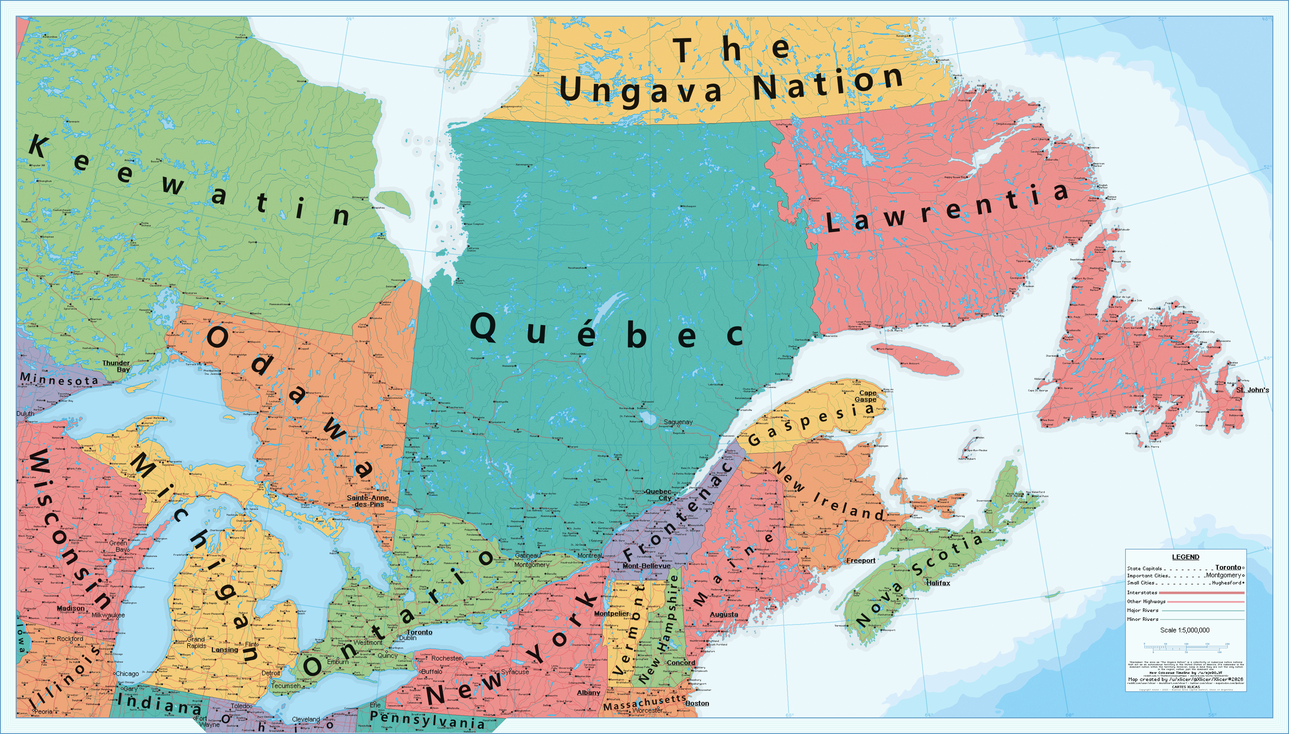
You gave me some map ideas guys...
Ok, idk why I went through with this.... I'm sorry :'( spare me pls guys :'(:'(:'(🙏🙏
dX8FgmO.png
 
I chose to split up Austria because the Soviet offense was delayed due to the loss of Vladivostok so the US had to send lend lease through the artic and Persia. I wasn't sure how far into Europe the Soviets would get.
I agree with Wendell, it seems to me that soviets, aside of Berlin, get as much ground in Europe as OTL, while having harder time than OTL (two front war! complicated lend-lease...)
On the other hand, Wallies in Europe may have been handicaped by later USA involvement (no/postponed Torch? invasion to Sicily and Italy?), on the other hand, Britain probably would, at least between Barbarossa and Netherland Indias occupation, concentrate its resources and forces in Europe even more than OTL (can, without Americans, drive Axis out of Africa? if, than I can see some attempt in Mediterranean, most, probably invasion on some island, for the start... Crete? Sicily?)
Also, what would happend with Vichy France/French (north) Africa with no (or postponed) Torch?
 
Actually I am reminded that some Russian oblast wanted to unite and form their own Republic.
Not for ethnic reasons but for economic ones.
The Ural Republic, yes. Though @kokesherus's map has it shifted eastwards, without Perm or Orenburg. There's a video by a Yekaterinburg-born pundit going in-depth into the history and legacy of this entity, if you can speak Russian and enjoy 50-minute lectures.

real Limonov hours
 
What if the US annexed Canada after the war of Independence? - The East Canadian States as of 2023 - The New Colossus

dfy9c25-e8fe0ef2-5620-4eaf-9c56-775eaf790ae7.png


DeviantArt Link

Hi alternatehistory.com. This is a map made for the one-year anniversary of the timeline "The New Colossus" made by reddit user and friend /u/ajw20_yt

This map focuses in on the Canadian states. Canada was annexed by the United States, not during 1812, but during the treaty of Paris in 1783. Nova Scotia and New Ireland were part of the 15 colonies, and a major part of this TL is focusing on the effects that these new states bring, such as more stripes and stars on all the flags, and free healthcare. After these states are admitted as free states, many southern politicians try harder at expanding, going for many areas of the Caribbean, such as in 1812 when America takes over Jamaica. You can see some of these alternate states in the northern areas of this map, with stations being named after them. Many cities around post-Canada also have Americanized names now.

As for post-Canada proper, Ontario is just like any other part of the great lakes. Toronto is Chicago's main rival, and is one of the larger cities that can be found there. Quebec still retained many French migrants and settlers as the years went on, and the culture, language, and rights of the French-Americans were protected from early on. Quebec stayed neutral in most American politics, but today still remains a large distinct cultural part of the United States. It's also worth mentioning that both Pierre Trudeau and Justin Trudeau serve as presidents of the United States, with Pierre Trudeau gifting America the aforementioned universal healthcare.

Thank you, and happy anniversary TNC. And I hope you all enjoy this map!
 
Status
Not open for further replies.
Top