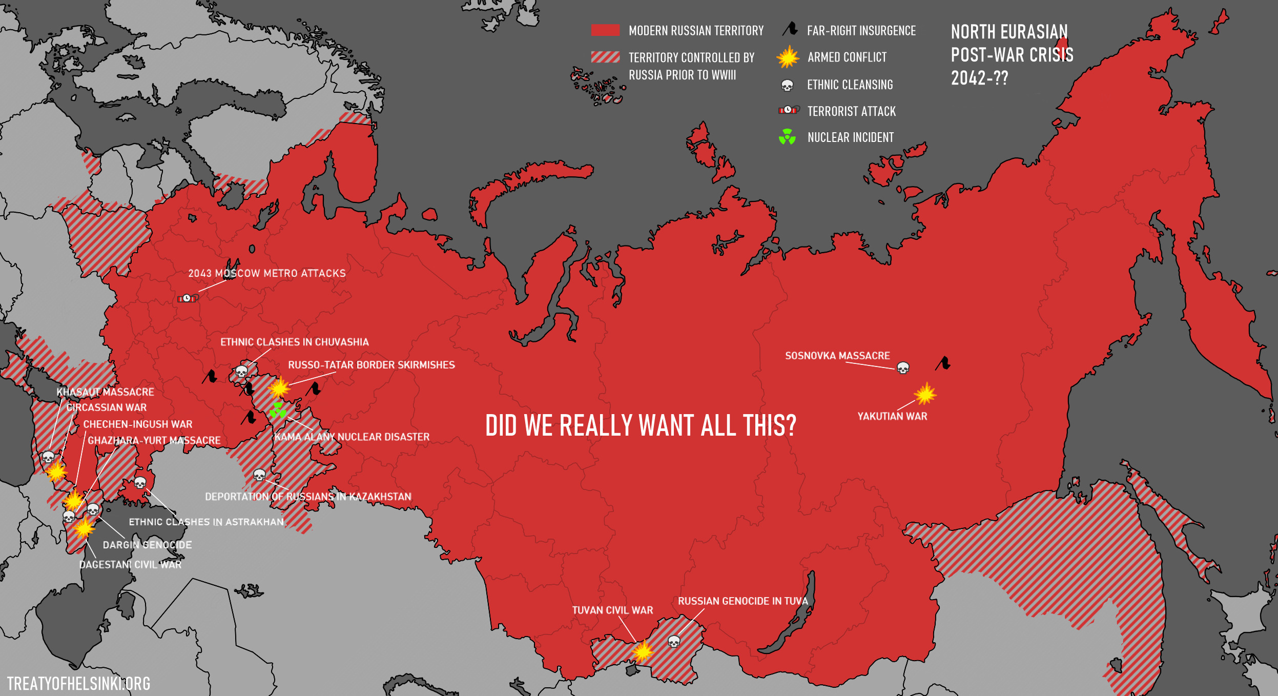
"Did we really want all this?" makes me think this is meant to be a Russian propaganda poster. Is that correct?Another attempt at a semi-realistic post-WWIII division of Russia... and its consequences.
Any similarity to current politics is coincidental. I just like these shapes.
You are using an out of date browser. It may not display this or other websites correctly.
You should upgrade or use an alternative browser.
You should upgrade or use an alternative browser.
Map Thread XXI
- Thread starter fluttersky
- Start date
-
- Tags
- map map thread
- Status
- Not open for further replies.
Threadmarks
View all 131 threadmarks
Reader mode
Reader mode
Recent threadmarks
[50+ Likes] Sultanate of England, by Sārthākā Big Nations series, by Alex0505 A re-projection of Jean Lattre's 1762 world map, by Ashtagon [50+ Likes] The Russo-Ukrainian conflict in context, by NeonHydroxide Rose, Tulips, and Liberty, by Unkown00 Caliphate of Albion 1450, by Sārthākā 1932 Centauri-Human War, by Alex0505 Bharata is the World (part 3) by wildviper121
Another attempt at a semi-realistic post-WWIII division of Russia... and its consequences.
Any similarity to current politics is coincidental. I just like these shapes.
Even in a map entirely about Russia... Iran still gets ripped off...and also Armenia? What happened to Armenia?
Devestating Azeri Victory
Great map though! I love the style.
Last edited:
I don't know why I made this. A cover of the North America of @Merovingian's insane soul draining Republic of New England.
.png")
(note: Louisiana is that way because it just lost a major war)
(note: Louisiana is that way because it just lost a major war)
Honestly pretty believable. Calls for Russian balkanization along Republic lines have been around in certain western circles for a while and have increased since the war with some proposals going pretty far. While it’s mostly confined to history nerds and redditors for now, I could see a more moderate version of such ideas, as shown in the map, being picked up by western governments if a world war broke out over [REDACTED CURRENT EVENT] or at least being one of many postwar proposals.Another attempt at a semi-realistic post-WWIII division of Russia... and its consequences.
Any similarity to current politics is coincidental. I just like these shapes.
Perhaps by the time it gets to WWIII I imagine Russia might occupy or annex more but perhaps this is more of a [REDACTED PERSON] launches nukes in a fit of madness or something.
The one thing I find odd is China, not because I think they’d be loyal allies of Russia (though I expect them to stay neutral throughout most of the war) but because joining the war and annexing land doesn’t seem super useful to them and seems contrary to their modus operandi. I imagine the Chinese would actually try not to sour reactions with Russia since such a weakened Russia could effectively be made into a Chinese vassal, and such a massive puppet across Eurasia if nothing else helps a lot with initiatives like Belt and Road by which China could project trade influence into Europe. Chinese companies would operate throughout Russia, Chinese investors would buy up much of the stock in major Russian companies, and the Chinese could easily get the right to base fleets in Primorye, giving them economic and military control of the region without having to sour relations with Russia or take in a Russian ethnic minority (even if that minority is tiny compared to the population china can throw at it in colonization projects).
TTL kind of plays right into China’s hands tbh or at least would if China didn’t annex Primorye (though even if it did, Russia might have no other choice but to align with China). We shouldn’t assume (and I don’t think you do) that just because the West won and maybe forced a democratic constitution that Russia would become pro western and liberal. I kind of see the Russia-China relationship developing along the lines of the current Serbia-Russia one (albeit with far less historic background). Russia, much like modern Serbia, has watched the west turn it into (to avoid making an opinionated statement, what it sees as) a rump state so it will remain anti western. Thus it aligns with the neighbouring, anti western, historically (or in Russia’s case at least in recent history) friendly superpower and rides it’s dick really hard, seeing it as the country that will right all wrongs against it, even if that expectation isn’t as realistic as they make it out to be. Right now, Russia is still powerful enough to make its own independent choices, meaning it sometimes clashes with China over things. ITTL that would not be the case.
SEATO is definitely making a comeback ITTL. Even if China were to go democratic and liberal (which, if this is just normal FH it probably hasn’t been long enough for that to happen) geopolitical and economic opposition with the US would remain. Though TBH SEATO will probably make a comeback IOTL too.
has Kazakhstan made any attempts at integration with the Tatars and the other young, small Turkic states on its border?
Last edited:
FireCrispyHistory
Banned
This is my attempt at a WWI stalemate. (This map is year 1920, in which the Ottoman Empire had taken over almost all of Arabia.)
Germany's Colonies: Kamerun gains the southern French Colonies as well as North Angola; Sudwest Afrika gains South Africa's little city and southern Angola. The Caprivi Strip is taken by Britain and made into the Caprivi Colony, soon to be split between Rhodesia and Bechuanaland; Belgium gains some western lands of Tanganyika, and Mozambique and Tanganyika draw a straight line, giving both sides a part of the other's territory; German and British Papua draw a straight line, giving both sides a part of the other's territory; Germany annexes Finland as the
Kolonie Finnland.
Ottoman Territory: The Ottoman Empire annexes Kuwait, Sinai and most of Arabia EXCEPT FOR Aden Colony, Oman and the Trucial States; Britain and the Ottoman Empire split the Suez Canal, named the Anglo-Turkish Territory of the Suez Canal.
Bulgarian Territory: Bulgaria annexes Macedonia and Thrace from Serbia and Greece respectively
Austro-Hungarian Territory: The Hungarian half of Austria-Hungary annexes Montenegro into the Protectorate of Montenegro, or Montenegró protektorátusa; The Hungarian half annexes the rest of Serbia into the Serbia Protectorate, or Szerbia Protektorátus; Austria-Hungary share the northern territory of Romania, named the Carpatho-Ukrainian Protectorate, or
Kárpát-Ukrán Protektorátus, or Karpato-Ukrainisches Protektorat; The Austrian Half annexes Venice, renaming it to the State of Venice, or Staat Venedig.
Last edited:
A "stalemate" in which the Central Powers are definitely getting the better end of.View attachment 777704
This is my attempt at a WWI stalemate. (This map is year 1920, in which the Ottoman Empire had taken over almost all of Arabia.)
How did the ottomans take over Arabia? Ottoman control of the desert regions was incredibly loose (as I understand it) and having them move even further in when they are still implementing reforms and having issues with nationalism, that seems a bit of a stretch. Not to mention the Saudis are backed to some extent by the Brits, and I see no reason for the Brits to give that up for a hostile power on their border.View attachment 777704
This is my attempt at a WWI stalemate. (This map is year 1920, in which the Ottoman Empire had taken over almost all of Arabia.)
FireCrispyHistory
Banned
I am guessing that after the Peace Treaty and the fact that Britain and the Ottomans now share the Suez that the Ottoman stability and trust in the government is better, now that they have taken quite a bit of land from Britain. Now, we all know that the Ottomans are about to just explode, but Britain would likely now rather have the Ottomans as an ally than a rival. They already have a rival in Russia (oh, and there was no Communist Revolution in this TL)How did the ottomans take over Arabia? Ottoman control of the desert regions was incredibly loose (as I understand it) and having them move even further in when they are still implementing reforms and having issues with nationalism, that seems a bit of a stretch. Not to mention the Saudis are backed to some extent by the Brits, and I see no reason for the Brits to give that up for a hostile power on their border.
The thought was that a separate Siberia would become a Chinese puppet in a millisecond. So, to prevent that from happening, the US pushed for more ehtnically Russian part of Russia to stay in one chunk. It may come in handy in the coming cold war with the Chinese.Still too big")
Too few Ingrians in existence.Why don't you try independent Ingria?
More like a Russian sympathizers' propaganda poster. Arguing that the peace treaty that was enacted was too harsh and brought all this bloodshed, and that Russia shouldn't have been divided."Did we really want all this?" makes me think this is meant to be a Russian propaganda poster. Is that correct?
Russia wasn't fighting the West alone.Iran still gets ripped off...and also Armenia?
Initially semi-neutral China simply backstabbed Russia when it was clear it's going to loose.China
Maybe it's going to, but so far not.has Kazakhstan made any attempts at integration with the Tatars and the other young, small Turkic states on its border?
Дуже гарна мапаRivne/Rovno (the Wall): Ukraine Divided
The map is inspired by the Ukrainian novel "Rівне / Ровно (Стіна)" ("Rivne / Rovno (the Wall)") by Oleksandr Irvanets'. And no, I haven't read it, I only know the premise, so this map would be a free interpretation of it.
So, somehow Ukraine got itself divided into two parts: Western Ukrainian Republic (under the jurisdiction of the UN) and the Socialist Republic of Ukraine. The city of the protagonist, Rivne, also suddenly got a wall in the middle of it, dividing the city into western Rivne and eastern Rovno. The protagonist lives in the western part and somehow (as I said, I haven't read this) gets into the eastern part, which could basically be described as if USSR never died in that particular area, with Communist Party still being in power. The novel, if what I was told is correct, ends with SRU invading Rivne, the western part, reunificating the city.
Now, the map itself. There are, obviously, two Ukraines: the Western and Eastern. The Eastern differs from the original in the novel in that it is not exactly a one-party state: there you can vote for not just one, but three "different" socialist parties (CPU, SPU, PSPU)! All of which are part of the same ruling coalition, "the People's Bloc", right. The flag is basically that of the Ukrainian SSR's, but with star replacing the hammer and sickle.
While de-jure Ukrainian is the official language of the SRU, Russian is much more prestigious socially (it is also a second official language, and is considered to be "the language of inter-ethnic communication"), with it being not uncommon for the records in the easternmost parts being kept exclusively in it. That is why, following novel's author's example, I used Russian version of the city names for the SRU.
And yes, Transnistria is now a part of SRU, because why not. It also got some parts of the Odessa oblast, practically recreating the old Moldavian Autonomous Soviet Socialist Republic, which was a part of Ukraine in 20s and 30s, before it got split between the Ukrainian and the newly created Moldavan SSRs in 1940. You can also see the internationally recognised border of Ukraine in that area, so you can compare and see the difference.
I'm not sure what to say about WUR. Well, it is very westernized and also hosts a primarily Polish NATO contingent and is, obviously, more free and prosperous than the Eastern Ukraine.
Though I haven't heard of the book before, frankly speaking, I like how attentive to detail this map is, down to the Moldovan SSR border and the city names. I find it mildly interesting that the Khmelnitsky Oblast is divided. The party system of East Ukraine as you have pictured it makes sense: it's in line with, say, modern China and 20th century Communist states in Eastern Europe — on that note, what's the party system of West Ukraine like?
I also like these shapes.Another attempt at a semi-realistic post-WWIII division of Russia... and its consequences.
Any similarity to current politics is coincidental. I just like these shapes.
Just have a few questions:
- Could you describe the Circassian War in more detail? The participants aren't immediately obvious from the map alone, I would say.
- Considering that a large part of northern Kazakhstan still has a Russian plurality/broadly Indo-European majority as of 2021 IOTL and isn't shown to have been occupied by Russia pre-WWIII, how exactly did expulsion of Russians go down in Orenburg Oblast?
- what's the deal with that Tambov/Penza/Simbirsk amalgamation
I figured that was the lore behind China’s annexation, you DID say semi realistic, and that border is visually appealing, but I still thought I’d give my 2 cents on what behaviour I (as a non expert though, so grains of salt are wise to include in digesting my analysis) I found more realistic or expected from China. Frankly I’m tempted to expand my “post WWIII rump Russia as a Chinese puppet” idea but I have too many projects as it stands.Initially semi-neutral China simply backstabbed Russia when it was clear it's going to loose.
Maybe it's going to, but so far not.
Sad. A Kazakh sphere of influence would be cool. Kazakhstan greatest country in the world after all, and ofc Kazakhstan is the real USSR.
Alright.View attachment 777704
This is my attempt at a WWI stalemate. (This map is year 1920, in which the Ottoman Empire had taken over almost all of Arabia.)
Germany's Colonies: Kamerun gains the southern French Colonies as well as North Angola; Sudwest Afrika gains South Africa's little city and southern Angola. The Caprivi Strip is taken by Britain and made into the Caprivi Colony, soon to be split between Rhodesia and Bechuanaland; Belgium gains some western lands of Tanganyika, and Mozambique and Tanganyika draw a straight line, giving both sides a part of the other's territory; German and British Papua draw a straight line, giving both sides a part of the other's territory; Germany annexes Finland as the
Kolonie Finnland.
Ottoman Territory: The Ottoman Empire annexes Kuwait, Sinai and most of Arabia EXCEPT FOR Aden Colony, Oman and the Trucial States; Britain and the Ottoman Empire split the Suez Canal, named the Anglo-Turkish Territory of the Suez Canal.
Bulgarian Territory: Bulgaria annexes Macedonia and Thrace from Serbia and Greece respectively
Austro-Hungarian Territory: The Hungarian half of Austria-Hungary annexes Montenegro into the Protectorate of Montenegro, or Montenegró protektorátusa; The Hungarian half annexes the rest of Serbia into the Serbia Protectorate, or Szerbia Protektorátus; Austria-Hungary share the northern territory of Romania, named the Carpatho-Ukrainian Protectorate, or
Kárpát-Ukrán Protektorátus, or Karpato-Ukrainisches Protektorat; The Austrian Half annexes Venice, renaming it to the State of Venice, or Staat Venedig.
Germany wouldn't gain anything in Africa (in fact they'd be more likely to lose it all), they wouldn't annex Finland, the Ottomans wouldn't be able to conquer nearly all of fucking Arabia (they'd very likely end up collapsing entirely), and the Austrians probably wouldn't annex Serbia/Montenegro/Venice (if anything, they'll make puppet states of the former 2).
The countries in our timeline after being transported into this timeline:
Syria:
View attachment 777308
It's possible this TTL's Syria is vary different from OTL Syria geopolitically. Syria was a region in this area of the middle east a number of times over the centuries, and it is no guarantee that this TTL's Syria is under SyrianArab leadership.
Syria ITTL is similar to the Jordanian state IOTL. It is a Hashemite monarchy initially put in by the British.It's possible this TTL's Syria is vary different from OTL Syria geopolitically. Syria was a region in this area of the middle east a number of times over the centuries, and it is no guarantee that this TTL's Syria is under SyrianArab leadership.
Why are the city names cross out on the second poster? Is one name the name the invaders give to those towns? Then why would a propaganda poster of the invaded acknowledge that second name?Anyways I'm kinda busy and I am focusing on my studies while doing these in my free time.
I would like to share a bit of Project Ocraria or Avatar: Republic and Beyond, maps, and posters from past months and currently.
Map with propaganda posters:


Maps:


Anyways the 2nd map is kinda wip'ish in the style of Pergamon atlas doing town naming and such but I have to share the base map because to put the topo and geographical stuff like in the TV news mountains that are dashed.
Probably it would be finished later this month or in October if I have some free time.
1. Basically the major cities in the mainland including the capital citiesWhy are the city names cross out on the second poster? Is one name the name the invaders give to those towns? Then why would a propaganda poster of the invaded acknowledge that second name?
2&3. Eh more of a old name from the past and re-using it in the lore of the TL which my buddy gonna write about it or its some dude in that universe making stuff up
Another attempt at a semi-realistic post-WWIII division of Russia... and its consequences.
Any similarity to current politics is coincidental. I just like these shapes.
So, the world didn't devolve into nuclear hellfire and mutant giant cockroaches when Russia was (presumably) invaded outright and forced to sign away large swathes of integral territory everywhere at the peace table for World War 3? Lucky! Though, not for long, it seems, what with this world looking to setting up for the fourth round (fought with stick and stones?): you'd think statesmen by now would learn to be kind on defeated enemies, lest they turn vengeful and irrendentist, like, I dunno, one Central European nation back in the 1930s.
Especially since all sorts of former Russian-occupied-aka-bullied states are apparently now committing genocide on the still-extant Russian diaspora... they better have some nuclear protection if they don't want to get noshed, unless Russia's similarly disarmed.
I'd imagine that West Ukraine's government is modeled after the Poland's, including party systems, though yeah, I know it sounds lazy, but I just can't come up with anything right now. Communist parties would be banned though, that is for certain. I'm not sure what sort of party (or, rather, a coalition) would rule in the western part, but I imagine it being economically left-wing, culturally right-wing with a pro-democracy rhetorics (and practics). Right-wing parties (in a rather nationalistic sense, not what we call economically right-wing) would be popular, though, because of the division and the SRU's threat.Though I haven't heard of the book before, frankly speaking, I like how attentive to detail this map is, down to the Moldovan SSR border and the city names. I find it mildly interesting that the Khmelnitsky Oblast is divided. The party system of East Ukraine as you have pictured it makes sense: it's in line with, say, modern China and 20th century Communist states in Eastern Europe — on that note, what's the party system of West Ukraine like?
Crazymachines
Banned
South America, In the year of our Lord and Prophet 1936
0. American Panama.
American Panama is American.
1. Republic of New Grenada.
Since the chaos surrounding its civil war in the early 1900s, New Grenada had managed to calm down considerably (aside from the occasional Mutualist terror cell), and is currently experiencing some much needed stability. Tacitly aligned with the United States for no other reason than fear of being eaten alive by the bloated Yankee empire to its north.
2. Republic of Venezuela.
Not officially an American ally, but heavily under the influence of the Ambrosia Oil Corporation, and various other Yankee business interests. Currently suffering from a Mutualist insurgency. (Mutualism is an ideology that advocates for a decentralized socialist society within a free market.)
3. Seminole Guiana.
The Seminole Republic, the USA's diplomatic fig-leaf and token good teammate, seized numerous British possessions in the aftermath of the Great War. It is currently exploiting them for every penny they're worth, for the Citrus products must FLOW.
4. Empire of Brazil.
Very closely allied to the United States, in no small part due to their shared pan-racial and totalitarian Fascist ideology. Rapidly progressing from an economic junior partner of Yankeedom into a prosperous industrial juggernaut in its own right.
5. Peruvian Republic.
The "Hermit Kingdom" of South America, Peru has been under an isolationist dictatorship continuously since 1885. The ruling regime espouses a policy of "Social progress and Development," but in all actuality spends most of its time robbing the country blind.
6. Republic of Charcas.
The Political system of Charcas can best be described as a 'praetorian democracy'. The elections aren't rigged, and the opposition parties are indeed legitimate, but the military is heavily involved in the government and watches like a hawk for anyone to step out of line. Currently engaged in a low level conflict with the Republic of Cordoba over control of the Gran Chaco.
7. Republic of Misiones
Possesses a much higher population and level of industrialization than OTL Paraguay. Honestly not a bad place to live, if you can stand the mild repression.
8. Federative Republic of Uruguay.
A vibrant, outward-looking democracy, governed by the National Dynamist Front since their landslide electoral victory in 1931.
(Dynamism is essentially an unholy lovechild of italian fascism, avant guarde futurism, and progressivism. the Dynamist worldview is that nothing in the universe exists or matters, save for F O R C E)
9. Republic of Cordoba.
Cannot into sea, but very much can into poverty. The butt of many, many, many regional jokes.
10. Republic of Chile.
A Junta in Latin America? Who could've guessed? The previous Mutualist government was overthrown by a military uprising in 1935. Now, factionalism within the officer corps is leading the government to become increasingly dysfunctional and unstable.
11. Republic of Buenos Aires.
Argentina may have broken up in the mid 1800s, but Buenos Aires is still thriving on its own. The Country is a rich industrial state with mass politics and a titanically powerful labor movement, and has been a fully democratic republic since the end of the Great War. It is also home to more Gauchos and Italians than you can shake a stick at.
Last edited:
Threadmarks
View all 131 threadmarks
Reader mode
Reader mode
Recent threadmarks
[50+ Likes] Sultanate of England, by Sārthākā Big Nations series, by Alex0505 A re-projection of Jean Lattre's 1762 world map, by Ashtagon [50+ Likes] The Russo-Ukrainian conflict in context, by NeonHydroxide Rose, Tulips, and Liberty, by Unkown00 Caliphate of Albion 1450, by Sārthākā 1932 Centauri-Human War, by Alex0505 Bharata is the World (part 3) by wildviper121- Status
- Not open for further replies.
Share: