Map Thread XX

Status
Not open for further replies.
Something I whipped up really quick after seeing all the ´´Three Germanies´´ posts.

This is an alternate Europe in the year 1960, during a slightly different Cold War. Germany was split into three parts after the war, with a democratic Germany in the west joining NATO, a slightly larger communist East Germany/GDR being a member of the Warsaw Pact and a neutral South German buffer state in the south (that was formed out of Austria and most of the American occupation zone). I hope you guys like it!

View attachment 580353

EDIT: Small East German flag fix.

Reminds me of one of Churchill's plans for Europe after the war... he wanted to create a Bavarian-Austrian-Hungarian state.
Interesting how you kept the prewar German-Polish border.

I like it!

edit: Sorry, I didn't realise there was about a page of posts between mine and yours.
 
unlike the colonisation of america, canada or new zealand, the british never acknowledged the aborigines as having any title to their land. i dont believe reservations were ever established for this reason.
map-of-land-aboriginals-own%2C-or-have-native-title-interests-to.-data.jpg
 
Ahhh, future. When I saw the map and flag I was thinking how disgusting the pizza Margherita would be here. It would be interesting to see the borders of Algeria in this world. The Italians on decent terms with the Greeks here, or still issues over the islands offscreen? Though I suppose the Turks, Greeks, or British would have Rhodes here, considering the Italians only grabbed it in the war they started with the Turks to seize Libya. Seems they only did it halfway here... I suppose the timeline will explain it all.
Pizza Margherita probably does not exist. IIRC, the futurists planned to ban pasta and pizza for... some reason...
 
Individual states and territories of Australia have only really started giving Aboriginal peoples their land back over the past few decades (and there aren't any actual formal treaties in place), and the Australian federal government still doesn't recognize any Aboriginal nation as sovereign.
 
I'm still working on the Ancient Near East maps and the scenario for those, but in the meantime here's something else I made, set in a timeline where (probably due to the Mongol conquests not happening) the Khwarezmid Empire survives for a few centuries longer before collapsing in the early 1800s.
1599097060583.png
Areas outlined in a country's colour are claimed by that country, areas filled with the paler version of a country's colour are occupied by that country. I was originally going to do all of Central Asia, including Qasaqstan (TTL Kazakhstan, formed from the eastern part of a surviving Kipchak Confederation, which in turn is Kipchakstan by the 19th Century) and Qitaistan (the result of the Kara-Khitai Khanate sticking around for longer), as well as TTL Kyrgyzstan in the north and TTL Afghanistan in the south, but it's late, so I just opted to stop here and then add some info on each of the countries shown.
 
Speaking of which, how's progress on that M-R alphabet wank going? Did you manage to recover any of the lost/corrupted files?

Nah, but I'm mostly done with an Iraq-to-Hungary map, and I've also gotten some ways with a Japan-Ireland map.

BackupWank.PNG


(Medieval POD for Japan, early Renaissance for Italy)
 
I'm trying to "pump up" my maps using Inkscape. This was my first attempt at hand-drawing coastlines/borders. I don't have the steadiest of hands on the mouse, so they're not as straight as I would have liked, but overall I'm pleased. Apologies if the bear obscures things; I got a little carried away layer wise.

0XeSBQz.png
 
Fair Meadows Map.png


Welcome to Fair Meadows

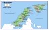
When you travel east from New York City onto Long Island, you would be familiar with the highways and the suburban sprawl that characterizes the region. The endless hamlets and towns that less than a century ago was a pastoral farmland now have lost almost all of their heritage. However, the further east you travel, the more the old ways become visible. Heading onto the East End is a world entirely on its own, with the small coastal villages that were characteristic of a bygone age dotting the landscape, the wide Pine Barrens filling the space between William Floyd Parkway and Riverhead, and a fork in the road going in two directions. The southern route takes you to the South Fork, known as the Hamptons, a getaway for the rich and famous, politicians and celebrities, and further than that the famous port and whaling town Sag Harbor and the furthest tip of Long Island, Montauk Point. However, if you go north through Riverhead and across the Peconic River, you find the North Fork. The region is littered with farms and vineyards, the small coastal villages continuing eastward. They are all familiar names, Aquebogue, Jamestown, and Laurel in the Town of Riverhead, before you cross into Mattituck and the Town of Southold. From there, you continue east on the North Fork, passing farm after farm, vineyard after vineyard, going through Cutchogue and Peconic, then Southold itself, the heart of an old town that was once a part of Connecticut, and the famed tourist town of Greenport before hitting a channel called the Trevelyan Pond. It cuts through the North Fork, the old pond now forming a channel between two pieces of land. Across the Trevelyan Pond you see two ways in, one on the north, where the Long Island Railroad (LIRR) crosses, and one in the south with a bridge and a large wood sign over the road titled "Welcome to Fair Meadows."

The first thing you would see upon entering Fair Meadows is Van Hoebeek, a small hamlet resting on the Trevelyan Pond. Although it lacks in size, consisting only of a handful of homes and several storefronts, and the Fox Lodge resting on a hill overlooking the Trevelyan Pond to the south, for many it is their first view of Fair Meadows. It is a flat region, hills dotting the northern side of the region, with marshes, meadows, and farms overflowing the southern end. At the Van Hoebeek Welcome Center you find a map of the small area called Fair Meadows. You would be mistaken in thinking it was its own town like Southold, Shelter Island, Riverhead, Southampton, or East Hampton. Like much of Long Island, there would be a small village at the center of a large town filled with hamlets and villages of their own. Flags of Fair Meadows fly next to flags of the United States in homes and businesses, the locals proud of their civic heritage. However, Fair Meadows is not a town, or even a unified village, but instead a collection of four villages east of Trevelyan Pond, separated from Southold by geography and heritage. For over three centuries, Fairhaven has been the largest settlement and the beating heart of Fair Meadows. It was the center of whaling and fishing on the North Fork and Long Island Sound for centuries. At one point it encompassed all of Grenville and Blue Point, but as new settlements with their own unique identities formed, so too did their incorporation as a village. Fair Meadows was the name of the region, but over time, with the villages politically independent from Southold in all but name, the people began to connect. In the 1820s, after Ketansett, the second largest village in the area was incorporated, the region fully took on the Fair Meadows name. A flag was designed, a unique culture of fishing and whaling and ferrying formed, and in the 1830s and 1840s there were petitions to make Fair Meadows its own town.

Although these attempts failed, by the time the American Civil War came along, and men of the four villages fought and died together, the Fair Meadows identity became the glue that bound these communities together. When the Church of the Reformed Covenant became popular in the 1860s and 1870s, the sect spread across Fair Meadows like wildfire. When the Ketansett Blues and Fairhaven Whalers were founded as minor league baseball teams in 1883, the Fair Meadows League was founded. When the Second World War saw U-Boat wolf packs scouring the waters around Long Island and sinking merchant vessels, it was young men from the four villages who volunteered for the Coast Guard Auxiliary to protect their shores, becoming Minute Men of the sea. To the rest of New York the differences between Fairhaven and Ketansett and Grenville and Blue Point were all unknown, and outsiders simply called the area Fair Meadows, a colloquial name similar to the Hamptons on the South Fork, or the Rockaways in Queens. In 2020, if you drive past the closed stores, the hospitals filled with patients, the roads empty as thousands work from home, the tourists nowhere to be found on a hot summer day, you can still see that Fair Meadows spirit. They hold their chins up high, they wave their flags, their symbol of the orange anchor and four blue stars scattered everywhere on signs and storefronts below only the stars and stripes, their unique community, recognized by New York State as a heritage area, standing as one community made up of four villages.

----------------------------------------
This is the wider universe of Ketansett, the village where I am setting my book Lights Far Away in. Do any of you have any questions? I suppose this is a worldbuilding project on the scale of Stephen King's rural Maine or more precisely William Faulkner's Yoknapatawpha County. I am thinking of doing an anthology of short stories set in this area.

Do any of you have any questions?
 

Attachments

  • Fair Meadows Map.png
    Fair Meadows Map.png
    331.8 KB · Views: 1,005
Last edited:
DO17Sp4.png

This is my entry for the B_Munro cover project. I went a different direction from the source material by casting aside most of the religious conflicts that characterized the map and instead focusing on a major political conflict--the largest political conflict in human history, the Great Eurasian Civil War, which began in 1784 AD and continues to the time this map is set, 1802 AD. This marks the close of a pseudo-cold war between the Great Khanate, the Confederation of New Europa, and their allies.

Yes, that is a "Brazilian" Raj controlled by Morocco. Yes, the People's Imperium of Themiscyra is indeed a matriarchal society (its population mostly consisting of native tribes and the descendants of Greek and Spanish refugees. Yes, the Sultanate of Muskat is different from Oman. I wish I could have mustered a better write-up, but I'm already a little late and don't have time to stretch this out further...
Honestly, from how hard you were hyping this up on discord, I was expecting the ECW to be wayyyy more chaotic than it actually was. Suppose that's the fault of your style, though.
 
Nah, but I'm mostly done with an Iraq-to-Hungary map, and I've also gotten some ways with a Japan-Ireland map.

View attachment 580454

(Medieval POD for Japan, early Renaissance for Italy)

Gonna have to say, compared to the Historical extent of Italy and Japan, their 20th century aims or their pre modern expension, compared to your other wanks these seem quite sane.
 
DO17Sp4.png

This is my entry for the B_Munro cover project. I went a different direction from the source material by casting aside most of the religious conflicts that characterized the map and instead focusing on a major political conflict--the largest political conflict in human history, the Great Eurasian Civil War, which began in 1784 AD and continues to the time this map is set, 1802 AD. This marks the close of a pseudo-cold war between the Great Khanate, the Confederation of New Europa, and their allies.

Yes, that is a "Brazilian" Raj controlled by Morocco. Yes, the People's Imperium of Themiscyra is indeed a matriarchal society (its population mostly consisting of native tribes and the descendants of Greek and Spanish refugees. Yes, the Sultanate of Muskat is different from Oman. I wish I could have mustered a better write-up, but I'm already a little late and don't have time to stretch this out further...
None of the French or English remnants seem labelled. Is that deliberate?
 
Top
Status
Not open for further replies.
Top