Map Thread XX

Status
Not open for further replies.
1623863266729.png


"We have always been at war with Eurasia"

- Lazar II Kotromanjić, King of the South Slavs, King of Serbia and of Bosnia, Prince of Syrmia and Zahumlje, Rector for life of Ragusa (or something, IDK)


So the other day I saw this religion map in the "Horrible Educational Maps" thread & it got me thinking. Among other things, the map had a Muslim Greece, Armenia, & Croatia, a Christian Bosnia, & Israel owning Lebanon. I figured I'd make those things happen in as plausible a way as I could, hence, this.

Bosnia, fearing for its life after the battle of Kosovo, makes itself a vassal ofthe ottomans. This makes the conquest lighter, instead of the 65 year-long process with the remnant in Herzegovina & all that, but also allows Christianity to remain dominant. The Ottomans, having lost less time & resources on Bosnia, in this period when they really were expanding all the time wherever they could, they end up taking Venice's overseas territories (Crete, Dalmatia, the Dodecanese). Control of the Adriatic allows them to have much more success in Hungary &, importantly, Croatia proper. The more solid hold on the Balkans due to less competition with Austria along with a little nudge in the form of a broad second POD allows islamization to be more successful in the Balkans (not insanely implausible given a few changes TBH), leading to the conversion of much of Croatia & Greece. The Ottoman empire later suffers a republican takeover, becoming a somewhat secular (albeit Islam plays a large unofficial role in the national identity) federal flawed democracy. The republicans allow Jewish settlement in the underdeveloped Palestine region, both from within the Ottoman area, after all Jews were quite well tolerated in the empire, & many that IOTL ended up in Sarajevo & elsewhere in Bosnia would end up in other major Jewish centers like Thessaloniki & Konstantinye, creating a significant Zionist lobby within the republic & collaborating with Zionists abroad to secure an autonomous province for the Jews (including Lebanon). An unfortunate part of the late imperial attempt to transplant European-style nationalism into the Ottoman state was the near complete evisceration of the Armenian people. After all, IOTL the biggest thing that saved the Armenians was that modern Armenia was part of Russia. Armenians in Turkey have basically been completely exterminated. They exist in a few pixels in OTL Armenia here (this is still quite a cursed world, see).

As for the wider Hungary breaks off quite quickly. Due to Austria never gaining Hungary, Russia's Balkan adventures are practically only stopped by the ottomans themselves at first and later by the British. Russia has much more direct influence in Romania & a larger slice of Poland (chances are the PLC would still go into decline & the Russians & Prussians were the ones behind it). Austria might unite Germany, without its Balkan focus, through centralizing the empire. The Hapsburgs were entrenched as Holy Roman Emperors by the POD so even with a reduced territory they had the potential. With a weaker Austria we do risk a stronger France, but that depends on a lot of factors, a less distracted Austria might just as well do better in the west but I still expect the Ottomans to attack, I'd certainly expect the British to have a thing or two to say about a rising France. Either I'm not developing a whole TL here so these are all the wider world hints. Also the thing in Vojvodina in the 1825 map is a Russian-backed Serb state.

Federal Cities:

  • Konstantinye (Istanbul)​
  • Izmir/Smyrna​
  • Thessaloniki​
  • Jerusalem​
  • Aleppo​
  • Bagdad​
  • Basra​

Notes:

- The "Turkmens" referenced in the ethnicity map are OTL Azeris. The ethnonym Azeri is quite new.
- The outlines in ethnicity are language families
- The "Alans" are Ossetians
 
Last edited:
View attachment 659453


"We have always been at war with Eurasia"

- Lazar II Kotromanjić, King of the South Slavs, King of Serbia and of Bosnia, Prince of Syrmia and Zahumlje, Rector for life of Ragusa (or something, IDK)


So the other day I saw this religion map in the "Horrible Educational Maps" thread & it got me thinking. Among other things, the map had a Muslim Greece, Armenia, & Croatia, a Christian Bosnia, & Israel owning Lebanon. I figured I'd make those things happen in as plausible a way as I could, hence, this.

Bosnia, fearing for its life after the battle of Kosovo, makes itself a vassal ofthe ottomans. This makes the conquest lighter, instead of the 65 year-long process with the remnant in Herzegovina & all that, but also allows Christianity to remain dominant. The Ottomans, having lost less time & resources on Bosnia, in this period when they really were expanding all the time wherever they could, they end up taking Venice's overseas territories (Crete, Dalmatia, the Dodecanese). Control of the Adriatic allows them to have much more success in Hungary &, importantly, Croatia proper. The more solid hold on the Balkans due to less competition with Austria along with a little nudge in the form of a broad second POD allows islamization to be more successful in the Balkans (not insanely implausible given a few changes TBH), leading to the conversion of much of Croatia & Greece. The Ottoman empire later suffers a republican takeover, becoming a somewhat secular (albeit Islam plays a large unofficial role in the national identity) federal flawed democracy. The republicans allow Jewish settlement in the underdeveloped Palestine region, both from within the Ottoman area, after all Jews were quite well tolerated in the empire, & many that IOTL ended up in Sarajevo & elsewhere in Bosnia would end up in other major Jewish centers like Thessaloniki & Konstantinye, creating a significant Zionist lobby within the republic & collaborating with Zionists abroad to secure an autonomous province for the Jews (including Lebanon). An unfortunate part of the late imperial attempt to transplant European-style nationalism into the Ottoman state was the near complete evisceration of the Armenian people. After all, IOTL the biggest thing that saved the Armenians was that modern Armenia was part of Russia. Armenians in Turkey have basically been completely exterminated. They exist in a few pixels in OTL Armenia here (this is still quite a cursed world, see).

As for the wider Hungary breaks off quite quickly. Due to Austria never gaining Hungary, Russia's Balkan adventures are practically only stopped by the ottomans themselves at first and later by the British. Russia has much more direct influence in Romania & a larger slice of Poland (chances are the PLC would still go into decline & the Russians & Prussians were the ones behind it). Austria might unite Germany, without its Balkan focus, through centralizing the empire. The Hapsburgs were entrenched as Holy Roman Emperors by the POD so even with a reduced territory they had the potential. With a weaker Austria we do risk a stronger France, but that depends on a lot of factors, a less distracted Austria might just as well do better in the west but I still expect the Ottomans to attack, I'd certainly expect the British to have a thing or two to say about a rising France. Either I'm not developing a whole TL here so these are all the wider world hints. Also the thing in Vojvodina in the 1825 map is a Russian-backed Serb state.

Federal Cities:

  • Konstantinye (Istanbul)​
  • Izmir/Smyrna​
  • Thessaloniki​
  • Jerusalem​
  • Aleppo​
  • Bagdad​
  • Basra​

Notes:

- The "Turkmens" referenced in the ethnicity map are OTL Azeris. The ethnonym Azeri is quite new.
- The outlines in ethnicity are language families
- The "Alans" are Ossetians
What happened to the Christians of Lebanon and the Arabs and other Muslims of Palestine ? What started the Armenian Genocide TTL ?
 
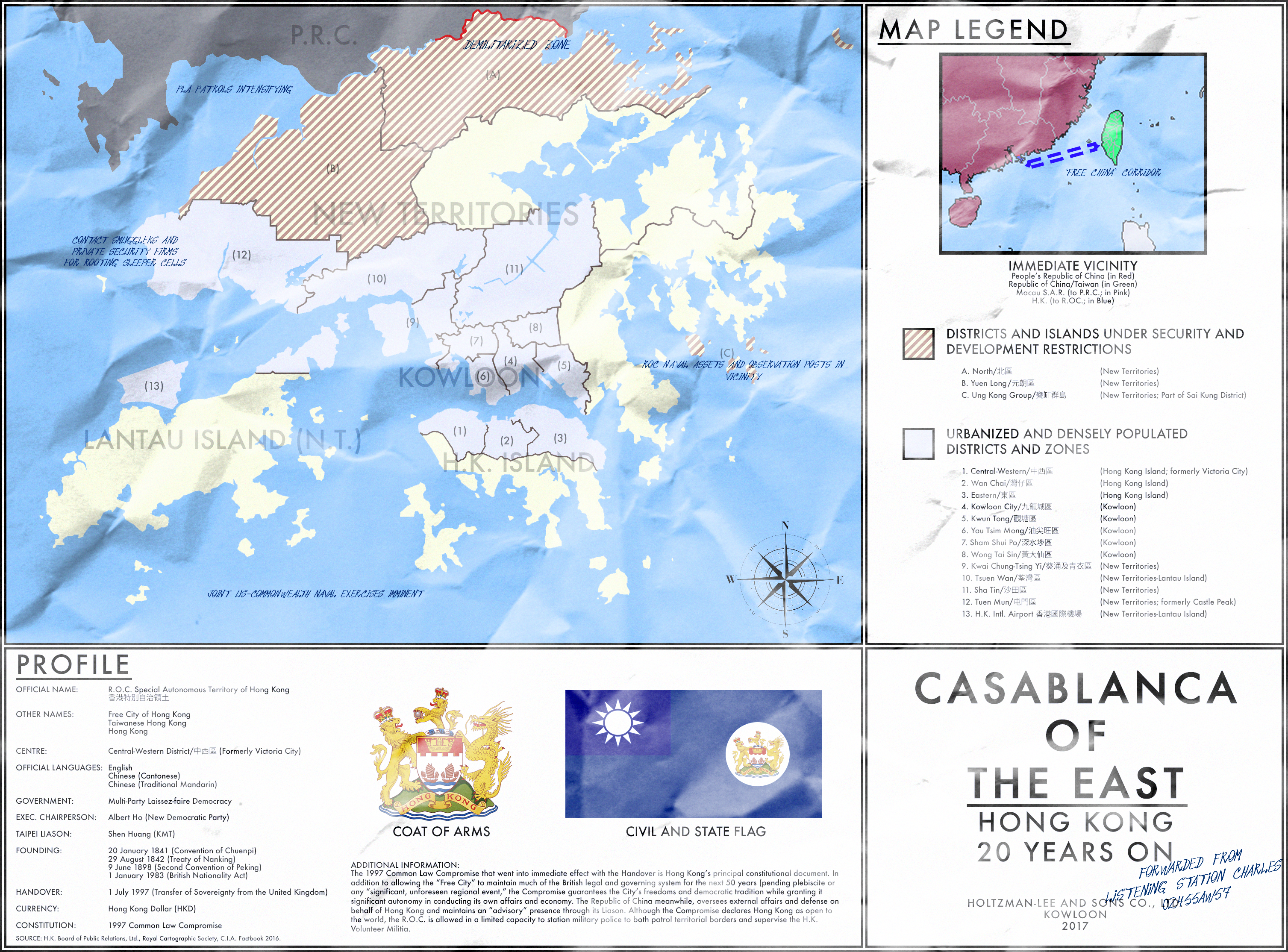
There was an excellent map by our very own @mdc_1957 (mdc01957 on DeviantArt) a few years ago, Casablanca of the East, with a very similar premise: while Macao is retroceded to the mainland as in OTL, deadlocked negotiations lead to Thatcher deciding to give China the middle finger and signs the Sino-British Agreement with Taiwan instead. The Free City of Hong Kong - now a "Special Autonomous Territory" of the RoC - has a far better relationship with its sovereign compared to OTL. Taiwan's considerably more hands-off approach, combined with Hong Kong's vibrant democracy and freewheeling economy, has led to the HK SAT becoming the closest thing to a corporate city-state on Earth.

dav0620-70f8ba02-2c5f-4077-85e7-e0d6c8767e61.png

More than symbolizing the end of an era for the British Empire, the Handover of Hong Kong represented a major historical shakeup in East Asia. To this day, even with long-declassified documents, historians and pundits debate the circumstances that led up to that momentous day in 1997. Some suggest that it was "Churchill's Janus deal" with the Kuomintang in the 1950s even while the UK formally recognized Communist rule in China. Other still point to the so-called "green tea parties" then-Prime Minister Thatcher arranged with both Beijing and Taipei, with the Taiwanese factor deliberately left out in the increasingly fruitless bargaining with the Mainland until the reveal of the Sino-British Agreement of 1984, which firmly set the stage for the Handover to the Republic, rather than the People's Republic of China; the press at the time recorded Thatcher's remarks on the matter as being a case "for the Chinese to decide" and more infamously, that "I'd rather see captains of industry than Communists overlooking Victoria Harbour." Regardless - with tensions by the 1970s-80s escalated to the point of several close calls and even scattered reports of skirmishes along the border - it seemed like a miracle that open war didn't occur, with the Mainland ultimately standing down from international pressure for pragmatic, economic reasons and under the begrudging pretense of one day allowing "peaceful unification" under the One Country Policy. So it was that, on 1 July 1997, Hong Kong saw the end of generations of British rule. A new chapter had begun.

It's been 20 years since then, and the Special Autonomous Territory of Hong Kong remains as vibrant and thriving as under its old colonial masters, though there's more to this than meets the eye. The 1997 Common Law Compromise, the main constitutional document, not only stipulates that the Territory is free to retain its old systems and customs for the next 50 years - pending plebiscite or any "significant, unforeseen regional event" - but both help allow and guarantee the freedoms and liberties enjoyed by the locals. While nominally under the Republic of China - represented in the so-called "Free City" by the Taipei Liason and with equal treatment in Taiwan's Legislative Yuan - Hong Kong has significant autonomy and leeway in running its own affairs, often either free of intervention or with tacit acceptance; although Taipei stepped in recently amidst calls to join the British Commonwealth in 2009 albeit as an observer, ostensibly to avert any potential escalation with the Mainland, such instances are the exception rather than the norm. In terms of external affairs and defense however, there's little doubt that the Taiwanese hold responsibility, with the R.O.C. armed forces allowed to send military police and other assets for security and overseeing the H.K. Volunteer Militia, itself directly descended from the British-era Royal Hong Kong Regiment. Due to both the delicate nature of dealing with the Mainland and desire to maintain the Territory's "openness to the world," military presence is officially borderline skeletal; this hasn't stopped the occasional visits from both the Royal Navy and American forces, nor has it prevented the Demilitarized Zone along the land border from being heavily guarded. And while there still remain activists and lobbyists calling for ever-greater autonomy if not outright independence, by and large the status quo remains firmly entrenched.

Another trend has become evident since the Handover, albeit one that had already been present for some time prior. Befitting Hong Kong's "openness to the world" and global economic weight, its brand of laissez-faire democracy has not only continued to thrived but is seen by pundits and economists to be evolving into what could be described as among the closest places the world has to a Corporate City-State; some go so far as to call it capitalism in its purest form. Over the years, privatization and the encroaching of both foreign and local businesses into the Territory's affairs have reached the point wherein conglomerates own whole neighborhoods, private security firms have proliferated - informally referred to as Hong Kong's other Volunteer Militia - and the Government outsources more public services to "approved" companies. Despite fears of wanton abuse as well as the risks, constantly invoked by both Beijing and the local Socialist Labour Party, of rampant inequality if not potential economic collapse, the present state of affairs has proven itself remarkably stable. Even with social tensions and at times fierce competition among local, Western, Taiwanese, Japanese and increasingly, Mainland businesses, most citizens have expressed generally firm satisfaction, particularly from the prestige and wealth coming in.

To understand the other side-effect to this state of affairs, one has to look past the neon lights and grand vistas. Given the Free City's reputation for being open to all, including the Communists across the border, it's also become a hotbed for more covert activity, and not just for corporate espionage or the occasional Triad transaction either. It's an open secret that in addition to the R.O.C. and P.R.C., the Americans and British are known to have listening posts and myriad secret cells, with assets from countries believed to also conduct secretive operations within the Territory's borders. All the while the influx of dissidents, political refugees and plain migrants seeking a better life continues seemingly unabated, though not to the same degree as during the Cultural Revolution; the claims of being a democratic and prosperous gate into "Free China" have only grown stronger over time, further bolstered by the local independent press. Despite all the potential for a major international incident to erupt at a moment's notice, most have little to no interest in openly changing, let alone putting a stop to such hijinks so long as the money continues flowing and people still at least superficially abide by civility. There's a reason why Hong Kong has also come to be known as the "Casablanca of the East."

This has only attracted more attention, and perhaps ire, from the Mainland Chinese however. Even with the reforms since the days of Chairman Mao or Deng Xiaoping and the economic ascension of the People's Republic, the Communist Party continues to look at Hong Kong with a sense of ambivalence. Not even the myriad white elephant projects and efforts to bolster the Macao Special Administrative Region - "returned" by Portugal in 1999 - as a glitzy, gambling haven have done much to really dent Hong Kong's status or position. More than once, there's been talk of blockading if not outright "liberating" the Free City should some heinous crime or act of sabotage be discovered. At this point, most have learned to pay little heed as not even the most stringent hardliners in Beijing would pull through with such threats, not at the risk of sparking a massive war that neither side wants nor with the so-called "Free China" corridor continuing to be maintained by the R.O.C. and its allies. Of course, the future remains an open book. Much can happen that can be unexpected.

Still, if the past 20 years have been any indication, then surely the next ones to come could only get better. At least that's the hope.
Yea, unless the PLA finds itself so severely crippled that it can't just swarm Hong Kong with tanks, there's not much to keep a Taiwanese Hong Kong from getting overrun. Maybe the Tiananmen protests turned into a full-scale civil war somehow, or Jiang Qing managed to escape and incites one against Deng's government.
 
Last edited:

View attachment 659453


"We have always been at war with Eurasia"

- Lazar II Kotromanjić, King of the South Slavs, King of Serbia and of Bosnia, Prince of Syrmia and Zahumlje, Rector for life of Ragusa (or something, IDK)


So the other day I saw this religion map in the "Horrible Educational Maps" thread & it got me thinking. Among other things, the map had a Muslim Greece, Armenia, & Croatia, a Christian Bosnia, & Israel owning Lebanon. I figured I'd make those things happen in as plausible a way as I could, hence, this.

Bosnia, fearing for its life after the battle of Kosovo, makes itself a vassal ofthe ottomans. This makes the conquest lighter, instead of the 65 year-long process with the remnant in Herzegovina & all that, but also allows Christianity to remain dominant. The Ottomans, having lost less time & resources on Bosnia, in this period when they really were expanding all the time wherever they could, they end up taking Venice's overseas territories (Crete, Dalmatia, the Dodecanese). Control of the Adriatic allows them to have much more success in Hungary &, importantly, Croatia proper. The more solid hold on the Balkans due to less competition with Austria along with a little nudge in the form of a broad second POD allows islamization to be more successful in the Balkans (not insanely implausible given a few changes TBH), leading to the conversion of much of Croatia & Greece. The Ottoman empire later suffers a republican takeover, becoming a somewhat secular (albeit Islam plays a large unofficial role in the national identity) federal flawed democracy. The republicans allow Jewish settlement in the underdeveloped Palestine region, both from within the Ottoman area, after all Jews were quite well tolerated in the empire, & many that IOTL ended up in Sarajevo & elsewhere in Bosnia would end up in other major Jewish centers like Thessaloniki & Konstantinye, creating a significant Zionist lobby within the republic & collaborating with Zionists abroad to secure an autonomous province for the Jews (including Lebanon). An unfortunate part of the late imperial attempt to transplant European-style nationalism into the Ottoman state was the near complete evisceration of the Armenian people. After all, IOTL the biggest thing that saved the Armenians was that modern Armenia was part of Russia. Armenians in Turkey have basically been completely exterminated. They exist in a few pixels in OTL Armenia here (this is still quite a cursed world, see).

As for the wider Hungary breaks off quite quickly. Due to Austria never gaining Hungary, Russia's Balkan adventures are practically only stopped by the ottomans themselves at first and later by the British. Russia has much more direct influence in Romania & a larger slice of Poland (chances are the PLC would still go into decline & the Russians & Prussians were the ones behind it). Austria might unite Germany, without its Balkan focus, through centralizing the empire. The Hapsburgs were entrenched as Holy Roman Emperors by the POD so even with a reduced territory they had the potential. With a weaker Austria we do risk a stronger France, but that depends on a lot of factors, a less distracted Austria might just as well do better in the west but I still expect the Ottomans to attack, I'd certainly expect the British to have a thing or two to say about a rising France. Either I'm not developing a whole TL here so these are all the wider world hints. Also the thing in Vojvodina in the 1825 map is a Russian-backed Serb state.

Federal Cities:

  • Konstantinye (Istanbul)​
  • Izmir/Smyrna​
  • Thessaloniki​
  • Jerusalem​
  • Aleppo​
  • Bagdad​
  • Basra​

Notes:

- The "Turkmens" referenced in the ethnicity map are OTL Azeris. The ethnonym Azeri is quite new.
- The outlines in ethnicity are language families
- The "Alans" are Ossetians
How do the citizens of Pontus feel about being governed from Athens (or whatever)?
 
Yeah, I don't get it. Yakutia secedes and so does Chukotka + surroundings, but this makes zero sense. Yakutia is sort of viable, but the far eastern state would practically instantly collapse. It implies Russia was invaded and broken up, but in that case, the annihilation would be total, and the invaders would seek to break up Russia into preferably neighobrhood-states.

Japanese... Sakhalin?
 

Deleted member 139407

New revamped version of the map of the world in 2050, as of my FHTL Ĉio Sub la Steloj which I'm going to reboot. Anything that catches your eye?
  1. There appears to have been quite the Civil War in the United States... California, Hawai'i, New England, the Pacific Northwest, and Texas have all seceded where as Alaska has joined Canada, Puerto Rico appears to still be under American influence, Native reservations have become officially recognized in some regards by the successor United States and there are various states in the succeeding US that have merged: Alabama and Mississippi; Arizona and New Mexico; Kentucky and West Virginia; Idaho, Montana, North and South Dakota, Wyoming; Maryland and Delaware; Nebraska and Kansas; Nevada and Utah.
  2. The West African Federation has officially come to fruition.
  3. Somaliland has been officially recognized and become fully independent as have Kurdistan, Tibet, and East Turkestan.
  4. Ethiopia has been split into a few pieces.
  5. Brazil seems to have been gifted a similar fate as the United States as numerous states have seceded and what I assume are Native reservations/claims are legally recognized on the map.
 
View attachment 659487
New revamped version of the map of the world in 2050, as of my FHTL Ĉio Sub la Steloj which I'm going to reboot. Anything that catches your eye?
What is that thing around Jerusalem? I would have guessed a joint city, but as Gaza and the West Bank have their borders with Israel colored grey instead of black, I am guessing it is something else. What is the green area on the coast by Assam? And what is the story in Burma? I doubt they need to look out for what the Bengali-speaking populace might think or give them autonomy with no Bangladesh, not that the government supports them much IOTL anyways. Is Thailand at a risk from refugees from Burma or posssible guerillas fighting for territory or to bring down the King? What are the grey stuff splashed around the Americas? I see it in Brazil, Panama, Canada, and US. Reservation areas? If so, I can’t help but wonder if Nunavut, the areas in northern Labrador (the province) and a couple areas in Alaska and the Prairie Provinces wouldn’t be in order. Or does the Canadian government not tolerate that sort of thing here and mostly gave what specks there are in Ungava as part of an effort to reinforce keeping the land from Quebec? Does the north or south dominate in Azerbaijan here? And I am guessing the Shia Arab state is in bad terms with every country to border it? Unless the former Saudi coastal area is also Shia Arab. Hmmm, what is the story behind the Asir? Does it have already relations with Yemen? And why did the Europeans take the Channel Islands? Doesn’t seem like a high priority for them for what little gain they would get. Also looks like the British have Bouvet Island here. Mistake with the base map? And for the autonomous province near Canton. I read they were given a coastline to build them up as support by the central government against that rich province. Do the autonomous autonomy here have more autonomy? Or is there a reason for them being added? I don’t believe they have much secessionist feelings there.
 
Last edited:
What happened to the Christians of Lebanon and the Arabs and other Muslims of Palestine ? What started the Armenian Genocide TTL ?
1) for the most part they're still around. The Christians are (as you can see from some enclaves) there, but in most areas, not as the majority, hence why they don't show up quite as much. The Muslims in Palestine are a harder to explain. Part of it was because I was following the erroneous religious map that inspired me, but with them it's mainly nothing much. They are largely just no longer the majority in these areas & were just outsettled in most areas by a lot of Jews, the region was kind of underpopulated before, though I will admit the large amount of majority Jewish areas are quite handwaved.

2) Basically, the late empire failed primarily because it tried to force a single national identity on its subjects. Among them, the Armenians were used as a sort of scapegoat minority: widespread, especially in the cities, Christian ("just like those dirty rebels in northern Rumelia", ie. Serbs & Bulgars) so they can be seen as potential separatists, & the idea is that because they don't conform to the main tenet of this national identity, Islam, it's easy to sell them as "sabotaging the empire from the inside", easy to blame a lot of problems on them while the empire modernizes, & this spirals into a horrific cycle of violence & outright genocide.
How do the citizens of Pontus feel about being governed from Athens (or whatever)?
Either Larissa or Lamia is the capital of Greece. Pontic people are decently ok with it. The states are mainly a thing for the ethnic minorities, & it is all inside a country. Decentralization is there so it gets messy sometimes, but not that much. There would, I expect, be some movement for integrating into Rum, but it's not too strong, more like the larger US state border change proposals, like the state of Jefferson.
You forgot to label Armenian Church on religion tab
Since it's such a smaller group ITTL, it gets lumped into Orthodoxy on the map, the only reason the other tiny church, the Church of Bosnia, is shown, is because it's so outside of most other Christian denominations (IK the Armenian church has its uniquenesses as well, but not as much as the COB). That's about all it is.
 
How did Mutapa manage to grow so much?
The thread for my TL explains this much more thoroughly than anything I can post here could, but the short answer is basically that the "Mutapa Empire" portrayed here isn't the OTL Mutapa but rather an HRE-esque feudal state formed by the Rozvi Empire in the early 19th Century via defeating Shaka Zulu in an alliance with the Dutch. Through a combination of integrating neighboring kingdoms and a much earlier industrialization than the rest of East Africa (many coastal African states, particularly in the west, actually undergo an industrial revolution in the early and mid 19th Century ITTL), the Mutapa rapidly expand northwards against their unindustrialized and more isolated neighbors, reaching as far north as OTL southern Somalia by the 1850s. While the Mutapa Empire has always been more centralized than the similar HRE thanks to the Rozvi taking advantage of a loosely defined tributary system, the new Mutapa emperor has dramatically centralized control over internal kingdoms by forming the Mutapa Inquisition as a personal secret police force and paramilitary, influencing the Mutapa Reformed Church, and using military force against internal monarchies who he opposes.
 
Independent Scotland and united ireland!! Well independent of the UK but part of the European Federation or what is that blue blob called?
United States of Europe, but yes.
I'm more perplexed by the Kuban being in, but not Greece or Sweden.
Well it came about when Russia fell into civil war after Putin's death. European forces aided one clique in Russia's south and kept it independent after the war's end. When the USE formed in 2037, it joined; Sweden declined to join and Greece wasn't invited (it left the EU in the 2020s).
Yeah, I don't get it. Yakutia secedes and so does Chukotka + surroundings, but this makes zero sense. Yakutia is sort of viable, but the far eastern state would practically instantly collapse. It implies Russia was invaded and broken up, but in that case, the annihilation would be total, and the invaders would seek to break up Russia into preferably neighobrhood-states.
Correct(ish), Russia fell into civil war. Beringia in the east was a filibuster state kept afloat by a Reddit campaign. (Official languages: English, Russian, Chukchi, Koryak, Itelmen)
Japanese... Sakhalin?
Yup! (Official languages: Japanese, Russian, Ainu, Nivkh)
  1. There appears to have been quite the Civil War in the United States... California, Hawai'i, New England, the Pacific Northwest, and Texas have all seceded where as Alaska has joined Canada, Puerto Rico appears to still be under American influence, Native reservations have become officially recognized in some regards by the successor United States and there are various states in the succeeding US that have merged: Alabama and Mississippi; Arizona and New Mexico; Kentucky and West Virginia; Idaho, Montana, North and South Dakota, Wyoming; Maryland and Delaware; Nebraska and Kansas; Nevada and Utah.
  2. The East African Federation has officially come to fruition.
  3. Somaliland has been officially recognized and become fully independent as have Kurdistan, Tibet, and East Turkestan.
  4. Ethiopia has been split into a few pieces.
  5. Brazil seems to have been gifted a similar fate as the United States as numerous states have seceded and what I assume are Native reservations/claims are legally recognized on the map.
Yes. (Native reservations are unchanged in status.)
What is that thing around Jerusalem? I would have guessed a joint city, but as Gaza and the West Bank have their borders with Israel colored grey instead of black, I am guessing it is something else.
Under direct control of the Baghdad Accord, a multinational organisation controlling most of the Middle East.
What is the green area on the coast by Assam?
A Rohingya state.
And what is the story in Burma?
Civil war.
I doubt they need to look out for what the Bengali-speaking populace might think or give them autonomy with no Bangladesh, not that the government supports them much IOTL anyways. Is Thailand at a risk from refugees from Burma or posssible guerillas fighting for territory or to bring down the King?

What are the grey stuff splashed around the Americas? I see it in Brazil, Panama, Canada, and US. Reservation areas?
Yes.
If so, I can’t help but wonder if Nunavut, the areas in northern Labrador (the province) and a couple areas in Alaska and the Prairie Provinces wouldn’t be in order. Or does the Canadian government not tolerate that sort of thing here and mostly gave what specks there are in Ungava as part of an effort to reinforce keeping the land from Quebec?
I don't know, I haven't changed this from OTL.
Does the north or south dominate in Azerbaijan here?
Probably pretty even, though both sides hate each other. The capital's still in Baku.
And I am guessing the Shia Arab state is in bad terms with every country to border it? Unless the former Saudi coastal area is also Shia Arab.
Nope, they're on pretty good terms.
Hmmm, what is the story behind the Asir? Does it have already relations with Yemen?
Saudi Arabia also collapsed into civil war.
And why did the Europeans take the Channel Islands? Doesn’t seem like a high priority for them for what little gain they would get.
Britain abolished the monarchy in 2028 and thus split up all of its remaining colonies.
Also looks like the British have Bouvet Island here. Mistake with the base map?
That's not intended.
And for the autonomous province near Canton. I read they were given a coastline to build them up as support by the central government against that rich province. Do the autonomous autonomy here have more autonomy? Or is there a reason for them being added? I don’t believe they have much secessionist feelings there.
Guangdong was split up into three provinces: Guangzhong, Jiangkou, and Hanjiang, the first receiving Chinese-populated areas of Guangxi during the reorganisation of Chinese provinces.
 
1623793185533.png

Above map: green territory is controlled by the Government of the Republic of Bogondo; yellow is territory controlled by the Front for a Democratic Bogondo (FDB).

War in Bogondo: Africa's Worst Humanitarian Crisis

A report by the United States Department of States catalogues Bogondo as a "failed state" and "the most dysfunctional republic in modern Africa". The failure of a country which once boasted the third highest GDP per capita in the continent and the fastest-growing economy in Sub-Saharan Africa for over two decades can be traced to its very founding. The land which would one day become Bogondo was absorbed by the British Empire in the early XX century. It was quickly discovered that the colony was rich in mineral resources such as copper and gold, attracting settlers and economic investment. Bogondo's natural wealth afforded it unparalleled prosperity. However, the latter was distributed very unequally: the profits were seized by a small white minority while the native black population, which accounted for 93% of the total, received not even a tenth of it. These inequalities persisted into the 1940's and 50's; by this point, the European colonial empires were being dismantled and its inhabitants were granted independence.

The British were keen to carry out this process in Bogondo. A controversial subject is whether they were too keen, and many believed independence should've been delayed until more solid groundwork was constructed. Nevertheless, the State of Bogondo was established on 1 January, 1955, after regional elections delivered overwhelming results for the pro-independence parties. The inaugural prime minister was John Kassimba, an accountant and colonial administrator, part of the minuscule elite of educated blacks. It is worth mentioning that early Bogondo was still closely tied to Great Britain: Elizabeth II remained the head of state, officials from the colonial era remained in their posts, and all economic power remained concentrated within the small Anglo-Saxon population. Calls for reform were silenced by Kassimba, who depended on the white elite's backing and so avoided alienating them.


In 1959, mutinies broke out as soldiers protested low pay and overall neglect from the government. They seized control of the barracks, murdered their officers, and went out for a frenzy of looting, death, and destruction. Soon enough, most of the remaining white population fled to Europe or South Africa, bringing with them their money and expertise. This flight of human and material resources was Kassimba's deathblow, and within weeks the soldiers had occupied Jamboto. The prime minister was unseated by Gen. Farrakhan Lombe. He aligned Bogondo with the Soviet Union, declared the country a republic, and began a series of Marxist reforms such as the forceful redistribution of land from white owners to impoverished black farmers and the expropriation of foreign companies.

Measures like these had a devastating effect on the country's economy. Soon enough, most Bogondans lived in a state of absolute poverty, and the Lombe administration became dependent on foreign aid from the USSR. Discontent was rapidly rising. The United States would eventually capitalize on this, and in 1967 the Johnson administration covertly supported Lt. Gen. David Sarombi's coup against Lombe. Sarombi put an end to pro-Soviet policies and began diverting Bogondo back to capitalism, and the economy began to recover with U.S. aid. Around this time began the economic exploitation of the extremely mineral-rich Ushunti Hills, which swiftly became the backbone of the Bogondan economy. By 1980, 96% of the nation's GDP came from mining operations in the Ushunti Hills.

David Sarombi would govern Bogondo from 1967 until 1983. Financial turmoil during the early and late 1970's caused the copper and iron markets to crash, essentially killing the nation's economy and bringing about discontent. Sarombi's regime was highly authoritarian, as any form of political opposition was decried as "socialist subversion" and shut down. Elections were repeatedly rigged (even though Sarombi was always the only approved candidate), and human rights violations became routine. Western nations tolerated Bogondo's descent into authoritarianism since Sarombi was a staunch anti-communist, and so the U.S. quietly bankrolled his government. Sarombi tried to implement reforms, but the U.S. felt these were too Marxist in nature. In 1983, Sarombi was deposed in a bloody U.S. backed coup which installed Gen. Omar Kombe. Reforms were cancelled, and Bogondo continued its negative trajectory.

By 1991, the USSR had collapsed and the U.S. had little reason to accept anti-communist dictatorships. America immediately cut off funding for Kombe, and Bogondo was once again thrown into disarray. The early 90's saw the rise of ethnic guerrillas and other such armed groups, mostly defecting soldiers and impoverished rural folk forced to commit desperate acts by the devastating economic crisis. The capital of Jamboto became engulfed in riots and protests, and the international community unanimously condemned Kombe. In 1992, Kombe was assassinated. This event marks the beginning of the Bogondan Civil War, the longest conflict in contemporary African history.

The extreme duration of this war and the great difficulty of stopping it even temporarily can be boiled down to one single factor: the Ushunti Hills. Rebel groups all have fought for control of these mines, as there is serious money to be made. Minerals sourced illegally from Bogondo has become so widespread that several countries have passed laws specifically targeting this issue. So far, thirteen separate peace proposals have been made with the goal of ending the civil war, and all have failed due to discontent over the allocation of the Ushunti Hills.

Since 2008, several different groups and guerrillas have coalesced into the Front for a Democratic Bogondo (FDB), led by warlord and former Bogondo Army officer Rupert Kimbele. This roughly coincided with the beginning of Operation Thunder Peace in July 2007, a multinational task force deployed to ensure stability in southern Bogondo. Various groups were wiped out by Thunder Peace, leaving a vacuum later filled by the FDB. By 2010, the FDB had fully taken over the Ushunti Hills, either destroying or expelling rival factions. Despite this achievement, the frontlines have since remained static. This is reported to be due to internal divisions between pro- and anti-Kimbele groups within the FDB, the strengthening of the Bogondan military under President Jamir Olengo beginning in 2012, and stricter international trade regulations which have made profiting off the Ushunti Hills more difficult.

In recent years, the Bogondan Civil War has become a topic of extreme concern due to the humanitarian toll it has taken. Since 1992, over 6 million people - 20% of Bogondo's population - has fled the country, with roughly 14 million being internally displaced. Three out of five Bogondans live under a critical food situation: malnutrition in children has risen 350% since 2006, and the life expectancy has decreased to 46 years, the lowest in Africa. The United Nations have called the war in Bogondo "the single worst humanitarian challenge the world faces as of today", with the U.S. State Department declaring it "the greatest disaster any one nation has encountered since World War II". Disease, starvation, rape, ethnic violence, human trafficking, and other such problems have wracked communities both inside and outside Bogondo, including in refugee camps established outside the country's borders. The massive influx of refugees has strained the capacity of neighbouring states, aggravating the extent of the crisis. The total of fatalities is a matter of academic contention, with estimates ranging from 2 million to over 9.5 million since the war's beginning in 1992, the vast majority of whom have been civilians.


Report on the War in Bogondo, 2015.
PhD, Parker, M.; Josiah, D.; Cheung, A.; et. al
 
Since it's such a smaller group ITTL, it gets lumped into Orthodoxy on the map, the only reason the other tiny church, the Church of Bosnia, is shown, is because it's so outside of most other Christian denominations (IK the Armenian church has its uniquenesses as well, but not as much as the COB). That's about all it is.
I mean, don't you have it as few red pixels near lake Sevan, that are not described in a legend?
 
Top
Status
Not open for further replies.
Top