Can you post the original map?This is a dumb idea I might turn into a timeline. All the subdivisons are from a supposed 'Map of Communist America' I dug up from the '50s or so.
View attachment 628691
The former Union of American Peoples' States in 2010, seven years after its collapse.
Dark Green - Oregon Republic, consisting of the former Oregon Peoples' State, Washington Peoples' State and the Blackrock Consolidated Autonomous Peoples' Territory
Medium Green - Jefferson Republic, the former North California Peoples' State and the Elko Consolidated Autonomous Peoples' territory.
Light Blue - Southwest Republic, consisting of the former South California Peoples' State and Arizona Peoples' State
Brick Red - Colorado Federation, consisting of the former Colorado (as in the Colorado Plateau) Autonomous' Peoples' territory.
Yellow - Rocky Mountain State, consisting of the former Rocky Mountains Peoples' State
Blue-Purples - Republic of Deseret, consisting of the former Utah Peoples' State and the southern quarter of the former Montana Peoples' State (taken during the Idaho War in 2008)
Light Green - Republic of Montana, consisting of the rest of the former Montana Peoples' State and the Fort Peck Autonomous Peoples' State
Olive - Badlands Scandinavian Peoples' Republic, consisting of the former Badlands Special Union Territory, claimed territory of both the Dakota Federation and the Sioux State. Basically Transnistria with nukes.
Pastel Green - Sioux State, consisting of the former Sioux Autonomous Peoples' Territory
Light Purple - Dakota Federation, consisting of the former Dakota Peoples' State
Light Red - Nebraskan Peoples' State, UAPS rump state. Basically Belarus on meth.
Bright Blue - Sovereign Aryan Republic of Minnesota, consisting of the former Peoples' Republic of Minnesota.
Green traced with Blue - Red Lake Autonomous Republic, consisting of the former Red Lake Consolidated Autonomous Peoples' Territory
Brown - Sequoyah Free State, consisting of the former Sequoyah Consolidated Autonomous Peoples' Territory
Blue - United States of America, consisting of the former Sabine Peoples' State, Arkola Peoples' State, Missouri Peoples' State, Illinois Peoples' State, Michigan Peoples' State, Ohio Peoples' State, Allegheny Peoples' State, Pennsylvania Peoples' State, Virginia Peoples' State, Chesapeake Peoples' State, New York Peoples' State, Cincinnati Special Union Territory, Chicago Special Union Territory
Green - Second Vermont Republic, consisting of the former Vermont Peoples' Republic
Pale Yellow - Democratic Republic of Connecticut, consisting of the former Connecticut Peoples' Republic
Pink - New England Federation, consisting of the former Massachusetts Peoples' Republic and the Maine-Hampshire Peoples' Republic
Grey - Second Confederacy, consisting of the former Dixie Peoples' Republic, Georgia Peoples' Republic, and the Carolian Peoples' Republic
Russet - New Africa (Florida), consisting of the former New Africa Peoples' Republic
I hope you find this as cursed as I do. PoD is 1896.
You are using an out of date browser. It may not display this or other websites correctly.
You should upgrade or use an alternative browser.
You should upgrade or use an alternative browser.
Map Thread XX
- Thread starter Balkanized U.S.A
- Start date
- Status
- Not open for further replies.
It's "Empire of Japan, East Africa" so "日本帝國" + "東阿非利加" (now that I'm looking, there are two ways to write it)I feel like 東アフリカ would probably be a simpler name
Edit: while looking it up yeah it is Ateji but I dont know how grammatical the word you tried to make is, what exactly did you try to translate cause I can help
The colony was founded shortly after the Meiji restoration, so AFAIK ateji are still being used a lot. The old form of "koku" is also appropriate since the simplifications only occured after WW2.
The History of the United States was a Complicated one. It seems as if the United States was doomed to fail after their independence, what with all of the different cultures of each of the Colonies. Many consider the downfall of the US to have occurred with the New Constitution meant to replace the Articles of Confederation was blocked by many States and their delegation. This was due to many reasons, mainly because of disagreement on how this new constitution should be. This ultimentully leads to some states not ratified and blocked the New Constitution, leading to the original Articles of Confederation being kept. Tension grew between many states as Political Polarization became worse and worse. The buying of Louisiana was deemed useless and would be blamed for the Panic of 1804. Following many states' succession crises, the final blow that was considered for the young nation was in 1804, when Jefferson won the election. The New England states, claiming it as voter fraud, all declare to succeed from the union, except for Vermont as they never join the Union in the first place. With the aid of both Vermont and the UK, the US would be forced to recognize the new nation of New England. Eventually, the rest of the States would succeed and the US would be dissolved in 1807. Pennsylvania, Delaware, and New Jersey would remain with each other as the United Commonwealth of Columbia.
Thomas27
Banned
Impressive!
The last map I have to offer during this month's map speedrun trifecta. I was going to do a map of Qing dynasty Taiwan, but found that Taiwan under Japanese rule instead suited more to my tastes. Unlike the previous two, I really did try to polish up the stuff as best I can and experimented with some new styles I can incoporate in the future. With this done, I'll likely go back and finish up one or two older projects.
~
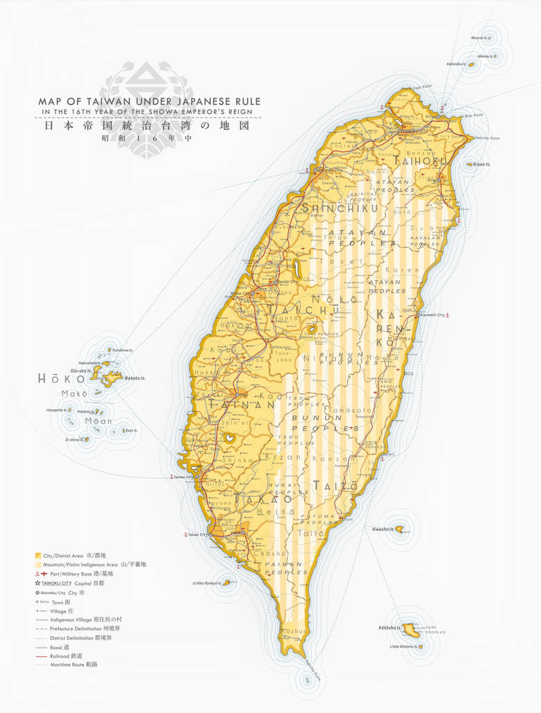
Taiwan Under Japanese Rule [OTL] by MarsandCadmium on DeviantArt
www.deviantart.com
The map looks nice, but why is Atlanta so far south compared to where it is IRL?View attachment 628821
The History of the United States was a Complicated one. It seems as if the United States was doomed to fail after their independence, what with all of the different cultures of each of the Colonies. Many consider the downfall of the US to have occurred with the New Constitution meant to replace the Articles of Confederation was blocked by many States and their delegation. This was due to many reasons, mainly because of disagreement on how this new constitution should be. This ultimentully leads to some states not ratified and blocked the New Constitution, leading to the original Articles of Confederation being kept. Tension grew between many states as Political Polarization became worse and worse. The buying of Louisiana was deemed useless and would be blamed for the Panic of 1804. Following many states' succession crises, the final blow that was considered for the young nation was in 1804, when Jefferson won the election. The New England states, claiming it as voter fraud, all declare to succeed from the union, except for Vermont as they never join the Union in the first place. With the aid of both Vermont and the UK, the US would be forced to recognize the new nation of New England. Eventually, the rest of the States would succeed and the US would be dissolved in 1807. Pennsylvania, Delaware, and New Jersey would remain with each other as the United Commonwealth of Columbia.
OTL Atlanta didn't even exist at this point. It's probably a different city with the same name.The map looks nice, but why is Atlanta so far south compared to where it is IRL?
I get that, but it just threw me off that a different city has the exact same of an OTL city and in the same geographic location.OTL Atlanta didn't even exist at this point. It's probably a different city with the same name.
Whoops, my mistake. It was met to be actual Atlanta. It was placed more southern because of the words.OTL Atlanta didn't even exist at this point. It's probably a different city with the same name.
Hello! After mostly lurking on this forum, with a mere 80 comments in almost 4 years, I've finally decided it's time to post my first real contribution. Here's a portion of a map I've been working on for the past two years (sporadically, though, so don't go around thinking it takes me that long to finish a map!!)

The nations it features are as follows: Circassia (Ādəɣă), Ossetia (Irɨston), Ingushetia-Chechenia (Noχčīčö-Ġalġajče), Avaria (Awaraš̄uliya), Georgia (Sakartvelo), Agbania (Aġvank), Armenia (Hayastan), Assyria (ʾĀṯūr), Aramea (Aramea-Ħamat), Jerusalem (Hierúsalem), Hejaz (al-Ḥijāz), Iraq (Erāk), Nejd (Naǧd), Asir (ʿAsīr), Yemen (Yāmān) and Mazoon (Mazūn).
The region can either be very religiously diverse or not at all, depending on whether you care about the different denominations of Christianity, or if you just lump them all together as Christians. The people of the region follow Catholicism in the Levantine coast (in Jerusalem and Aramea), the Orthodox Church mostly in the Caucasus (except Ossetia) and in the western parts of Yemen, the national Oriental Orthodox churches in Ossetia, Armenia, Agbania, Aramea, Hejaz and Yemen, and the Nestorian Church of the East in Assyria, Iraq and the rest of Arabia (Nejd). There's also the Zoroastrian Mazdaki nation of Mazoon. There are obviously other minorities, but that'd just be too long a list.
The Caucasus isn't as ethnically diverse as OTL, since a lot of smaller ethnic groups get assimilated into the majority populations of their respective nations, and there's less Turkic peoples and Slavs. Notably, there's no Circassian, Armenian or Assyrian genocides, Agbania is a Caucasian nation, with Persian influence, of course. Aramea and Jerusalem are both populated by Franco-Levantines, Syriacs, Melkites, Arabs, Druzes (who are an ethnoreligious Christian Gnostic group ITTL) and Samaritans. Iraq is populated by Turks, Kurds, Arabs, Syriacs, Mandeans, Jews and other Caucasians. The nations of the Arabian Peninsula are populated mostly by, you guessed it, Arabs, with Syriac, Turkish, Persian, Caucasian and Indian (mostly in coastal cities) minorities.
With all that said, I hope you like it!
PS: I added a whole lot of lakes to this region. Honestly, I forgot where I took them from exactly, as I made them while editing other QBAMs before I started working on this specific map. If you look up on Google "ancient lakes of" X region or "Green Arabia" you could probably find the pictures I originally used as a reference. To be honest, I'm so used to seeing those lakes that I just forget I put them there sometimes.
PPS: Don't ask about PODS. There's no general outline for this "TL" - it's an unholy amalgamation of PODS and features extensive butterfly genocide. Things that the butterfly effect would've surely prevented from happening ITTL, happen anyway. I'm just making stuff up as time passes on, and taking inspiration from the works of other alternate history timelines and maps.
PPPS: I also have dozens upon dozens of monarch wikiboxes ready to post, with several of them featuring those pertaining to this region. The countries that don't get a wikibox are either non-monarchies or I've been too lazy to make up one for them.
Last edited:
I hope you find this as cursed as I do.
You misspelled cool. Also, what happened to Rhode Island?
Eparkhos
Banned
Folded into the New York Peoples' State, roughly analogous to Kaliningrad.You misspelled cool. Also, what happened to Rhode Island?
Is everything roughly analogous to something?Folded into the New York Peoples' State, roughly analogous to Kaliningrad.
Eparkhos
Banned
No. I tried to do that starting out, but I got too complex to keep track of and I decided it would be more enjoyable forging my own path, so to speak. Although, Nebraska is essentially a hybrid Belarus/North Korea.Is everything roughly analogous to something?

It never existed.What have you done with Dallas
All a dream of Pam EwingIt never existed.
SureCan I post an almost finished map for MOTF here and ask for advice?
")
Map of the Partition of Vietnam from Nishijima Daisukes Dien Bien Phu. (Not mine, just wanted to share, hope its fine to do so)

- Status
- Not open for further replies.
Share: