I fully expect the Tsar to claim the North as Siberia 2.0.
You are using an out of date browser. It may not display this or other websites correctly.
You should upgrade or use an alternative browser.
You should upgrade or use an alternative browser.
Map Thread XVIII
- Thread starter FesteringSpore
- Start date
-
- Tags
- map thread maps
- Status
- Not open for further replies.
Sacrilege! It should be in Ocean City.
Clearly it should be Beach City.

Vuu
Banned
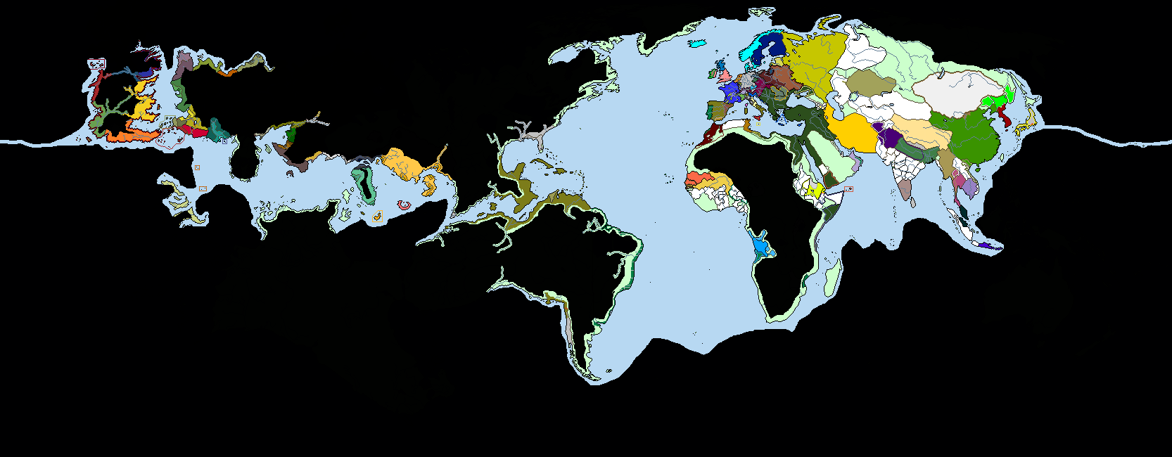
Basically what you could consider a reversed situation between the Greeks and the Illyrians. The borderless area is where they live, and the little red-gold things are colonies (yes, that's a lot). Other colored areas are polities that they have special trading relations with or find notable for whatever reason

Of course, this begs the question; what’s south of the Summer Islands and Sothoryos? Not to mention the rest of Essos/North America.
My only nitpick with the map is that Westeros seems to be a bit north, to where the North would be well into the Arctic Circle, though that could just be the projection of the map. Other than that, it’s a great map! I look forward to seeing Spain's interactions with Yi Ti, as well as future Europeans’ attempts to exploit Westeros.
Skallagrim
Banned
Magellan's Unexpected Journey
Very nice, and would be a great setting for an awesome story or TL. I must agree, however, with the criticism that the ASoIaF-part of this world is situated considerably too far North. This map format shows parallels as straight horizontal lines, and considering that there are vast forests north of the Wall, we may conclude that it should be located no further north than the Arctic Circle, and probably a bit south of it. (The tree line is mostly south of the arctic circle, and only in some places north of it-- and not by far.) This of course leads to the problem that certain other places then turn out to be too far south to be realistic. (Climatologically speaking: Dorne should be tropical it the resulting lattitude!) The core problem is that mr. Martin did poor world-building.
Anyway, you could solve it by tilting the ASoIaF map to the left a little, keeping Asshai where you put it, but tilting the map until the Wall is appoximately at the height of the Arctic Circle. That puts the shivering Sea north of Essos in the sub-arctic region, but puts Dorne on the level of the Sahara (more plausible, given its supposed climate). Naturally, you can also just apply handwavium.
That may be unavoidable anyway, since the implication is that this world is much bigger than Earth. The gravity would probably be a bit unpleasant.Still doesn't solve the problem of the climatic difference in the lenghts of seasons. But as earth must have a higher diameter, the scenario is ASB anyway. I would say to the maker just have fun with the premise and don't bother too much about believability.Very nice, and would be a great setting for an awesome story or TL. I must agree, however, with the criticism that the ASoIaF-part of this world is situated considerably too far North. This map format shows parallels as straight horizontal lines, and considering that there are vast forests north of the Wall, we may conclude that it should be located no further north than the Arctic Circle, and probably a bit south of it. (The tree line is mostly south of the arctic circle, and only in some places north of it-- and not by far.) This of course leads to the problem that certain other places then turn out to be too far south to be realistic. (Climatologically speaking: Dorne should be tropical it the resulting lattitude!) The core problem is that mr. Martin did poor world-building.
Anyway, you could solve it by tilting the ASoIaF map to the left a little, keeping Asshai where you put it, but tilting the map until the Wall is appoximately at the height of the Arctic Circle. That puts the shivering Sea north of Essos in the sub-arctic region, but puts Dorne on the level of the Sahara (more plausible, given its supposed climate). Naturally, you can also just apply handwavium.
Because @Serafim this is a great idea.
Hi. I'm asking the members of this thread that are known to make new maps what program they would recommend using for mapping. It has to be free because I don't have the money right now to buy something like PS, and I want it to have the features I need to create maps I make (if you don't know what types of maps I make, check out my profile. I currently use paint.net and it works fine except that I've had problems with the fill tool, something I use for all of my maps. Any reply to this recommending a program to use would be great, and I thank you all for reading this.
Jake
Jake
ST15RM
Banned
Paint.NET all the way. Unless you have a Mac, in which case your out of luck there.Hi. I'm asking the members of this thread that are known to make new maps what program they would recommend using for mapping. It has to be free because I don't have the money right now to buy something like PS, and I want it to have the features I need to create maps I make (if you don't know what types of maps I make, check out my profile. I currently use paint.net and it works fine except that I've had problems with the fill tool, something I use for all of my maps. Any reply to this recommending a program to use would be great, and I thank you all for reading this.
Jake
Oh, the paint bucket's not on aliased and/or has high thresholdHi. I'm asking the members of this thread that are known to make new maps what program they would recommend using for mapping. It has to be free because I don't have the money right now to buy something like PS, and I want it to have the features I need to create maps I make (if you don't know what types of maps I make, check out my profile. I currently use paint.net and it works fine except that I've had problems with the fill tool, something I use for all of my maps. Any reply to this recommending a program to use would be great, and I thank you all for reading this.
Jake
It's on aliased for sure, how do I prevent high threshold on paint.net?Oh, the paint bucket's not on aliased and/or has high threshold
ST15RM
Banned
Change the tolerance bar to a lower setting.It's on aliased for sure, how do I prevent high threshold on paint.net?
Hi. I'm asking the members of this thread that are known to make new maps what program they would recommend using for mapping. It has to be free because I don't have the money right now to buy something like PS, and I want it to have the features I need to create maps I make (if you don't know what types of maps I make, check out my profile. I currently use paint.net and it works fine except that I've had problems with the fill tool, something I use for all of my maps. Any reply to this recommending a program to use would be great, and I thank you all for reading this.
Jake
GIMP!Paint.NET all the way. Unless you have a Mac, in which case your out of luck there.
Gnu Image Manipulating Program for the winHi. I'm asking the members of this thread that are known to make new maps what program they would recommend using for mapping. It has to be free because I don't have the money right now to buy something like PS, and I want it to have the features I need to create maps I make (if you don't know what types of maps I make, check out my profile. I currently use paint.net and it works fine except that I've had problems with the fill tool, something I use for all of my maps. Any reply to this recommending a program to use would be great, and I thank you all for reading this.
Jake
The following is a map I made showing Central-Western Africa in @johnboy's timeline Rudolf will Reign, Dear. The map is of the year 1908, 8 years before the Great War. It focuses on the 8 provinces of the Kingdom of the Congo, which is in personal union with the United Hapsburg Empire (reformed Austria-Hungary).

Edit: The borders of German Cameroon don’t actually take effect until 1912 (partition of Morocco). Cameroon should consist of its OTL 1908 borders + Spanish Guinea.
Edit: The borders of German Cameroon don’t actually take effect until 1912 (partition of Morocco). Cameroon should consist of its OTL 1908 borders + Spanish Guinea.
Last edited:
Aren't Native Americans typically Democratic?
Indigenous faith being larger than any one of Catholicism, Protestantism, etc. does not mean it's a majority.
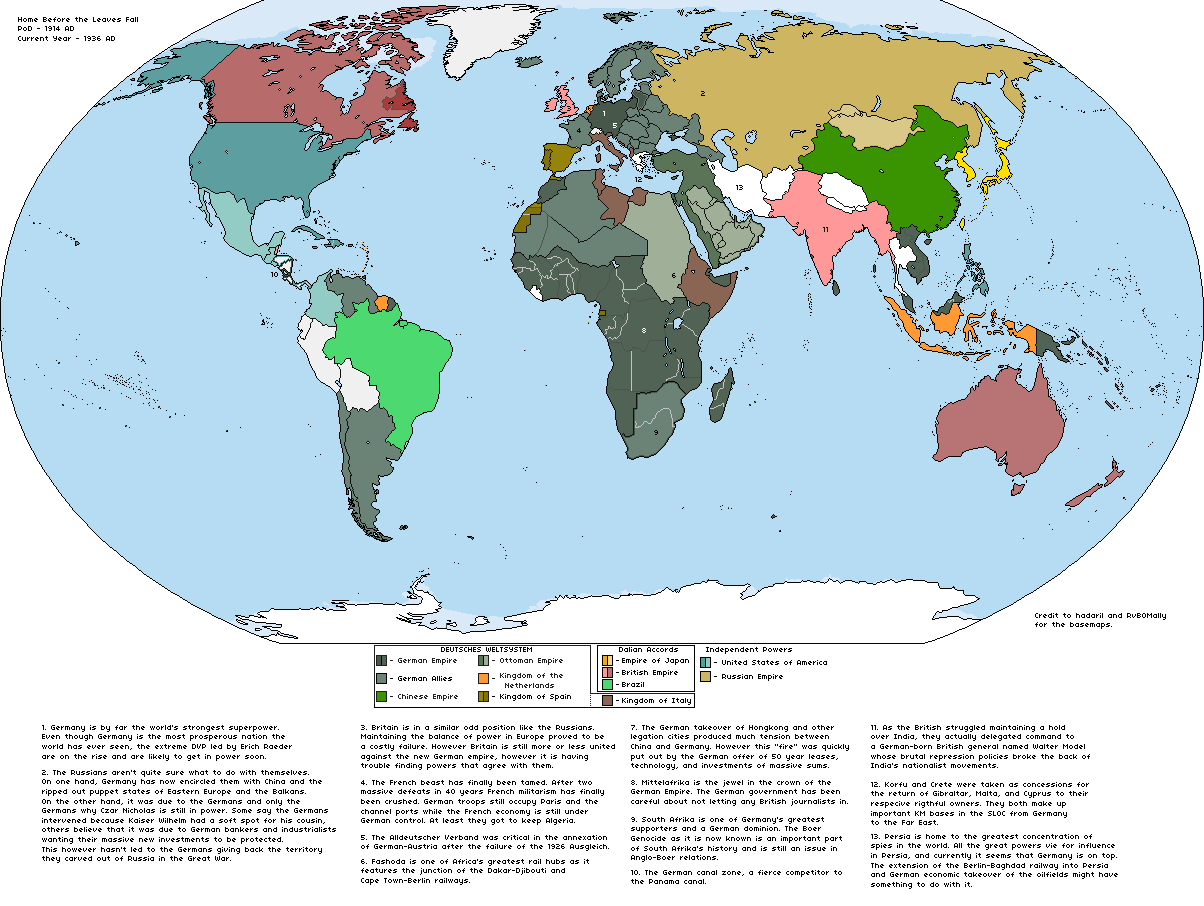
I haven't seen any Kaiserwank worlda maps around, so I decided to make my own. Here's a poorly thought out timeline to provide some clarity on how it happened, comments and suggestions are very welcome.
The death of David Lloyd George in the final days of July later proved to be the death of the whole British Empire. With Lloyd George dead, the liberal ministers resigned from the cabinet, throwing Britain into a political crisis. No matter Churchill’s desperate, bellowing cries for war, Herbert Asquith simply could not bring himself nor his government into a confrontation with Germany over Belgium until the snap elections were held, George Vth agreed. This delay proved to be fatal as the Germans were able to roll through Belgium and Northern France, crushing King Albert and his army in Antwerp, cracking the Trouée des Charmes at Verdun and Epinal, and finally encircling and later capturing Paris. With France at the brink and the British dealing with their Irish troubles, the Italians decided to grab a slice of France, joining in September, taking Briancon and Nice. Not long after Italian entry, Britain herself joined, however loss of the BEF at Rouen spelled the end of all British commitments on the continent. France signed the armistice on October 15th, 1914. Russia met disaster after disaster on the Eastern Front, first with their defeats at Tannenberg in August and later at Premissel in November. The war still persisted into 1915 but little went right for the Entente, Russia was pushed out of Poland and back into the Baltic, Ukraine, and Belarus, while the new U-boat bases on the North Atlantic coast proved to be devastating, bringing Britain to her knees.
On May 10th, 1915, exactly 44 years after the Treaty of Paris, the Treaty of Potsdam was signed, effectively handing over world hegemony to Germany. Wilhelm II was celebrated all over Germany and he promised to never allow Germany to find herself in her isolated, encircled position of 1914 again, thus the “Weltsystem” was born, a massive defensive and economic alliance consisting of over 20 countries. The year is 1936, the Anglo-Japanese alliance is stronger than ever, America is largely isolationist, however German activity in Central and South America is pushing her dangerously close to Britain. Russia stands aloof. The death of Wilhelm II spells concern for the future of the people, however, rest assured it will not be the end the German Empire, the German Century has just begun.
Last edited:
zhropkick
Banned
What font is this?
I haven't seen any Kaiserwank worlda maps around, so I decided to make my own. Here's a poorly thought out timeline to provide some clarity on how it happened, comments and suggestions are very welcome.
The death of David Lloyd George in the final days of July later proved to be the death of the whole British Empire. With Lloyd George dead, the liberal ministers resigned from the cabinet, throwing Britain into a political crisis. No matter Churchill’s desperate, bellowing cries for war, Herbert Asquith simply could not bring himself nor his government into a confrontation with Germany over Belgium until the snap elections were held, George Vth agreed. This delay proved to be fatal as the Germans were able to roll through Belgium and Northern France, crushing King Albert and his army in Antwerp, cracking the Trouée des Charmes at Verdun and Epinal, and finally encircling and later capturing Paris. With France at the brink and the British dealing with their Irish troubles, the Italians decided to grab a slice of France, joining in September, taking Briancon and Nice. Not long after Italian entry, Britain herself joined, however loss of the BEF at Rouen spelled the end of all British commitments on the continent. France signed the armistice on October 15th, 1914. Russia met disaster after disaster on the Eastern Front, first with their defeats at Tannenberg in August and later at Premissel in November. The war still persisted into 1915 but little went right for the Entente, Russia was pushed out of Poland and back into the Baltic, Ukraine, and Belarus, while the new U-boat bases on the North Atlantic coast proved to be devastating, bringing Britain to her knees.
On May 10th, 1915, exactly 44 years after the Treaty of Paris, the Treaty of Potsdam was signed, effectively handing over world hegemony to Germany. Wilhelm II was celebrated all over Germany and he promised to never allow Germany to find herself in her isolated, encircled position of 1914 again, thus the “Weltsystem” was born, a massive defensive and economic alliance consisting of over 20 countries. The year is 1936, the Anglo-Japanese alliance is stronger than ever, America is largely isolationist, however German activity in Central and South America is pushing her dangerously close to Britain. Russia stands aloof. The death of Wilhelm II spells concern for the future of the people, however, rest assured it will not be the end the German Empire, the German Century has just begun.
I've taken in advice for my ATL of a re balanced WWI, with this map set in the mid 30's. Any other tips?
Too far. They are farther than Alaska in OTLI fully expect the Tsar to claim the North as Siberia 2.0.
1)Of course, this begs the question; what’s south of the Summer Islands and Sothoryos? Not to mention the rest of Essos/North America.
2)My only nitpick with the map is that Westeros seems to be a bit north, to where the North would be well into the Arctic Circle, though that could just be the projection of the map. Other than that, it’s a great map! I look forward to seeing Spain's interactions with Yi Ti, as well as future Europeans’ attempts to exploit Westeros.
1) ASOIAF basemap is not mine
2) You're right. The map must be larger. But this crossover in any case exists due to magic. Lack of topographic self-consistency is normal. There are more serious problems. Season cycle, for example.
Thanks.Anyway, you could solve it by tilting the ASoIaF map to the left a little, keeping Asshai where you put it, but tilting the map until the Wall is appoximately at the height of the Arctic Circle. That puts the shivering Sea north of Essos in the sub-arctic region, but puts Dorne on the level of the Sahara (more plausible, given its supposed climate). Naturally, you can also just apply handwavium.
Unfortunately, the map cannot be rotated without loss of quality. I have no idea how to regulate the climate . The world of ASOIAF is bigger than Earth.
1) +N (N>9000)1)Still doesn't solve the problem of the climatic difference in the lenghts of seasons. But as earth must have a higher diameter, the scenario is ASB anyway. I would say to the maker just have fun with the premise and don't bother too much about believability.
2)Because @Serafim this is a great idea.
2) Thanks!
Vey refreshing to see a Kaiserwank that doesn't feature Communists running amok across half the planet
A couple questions:
- What did Germany do with the previous Anglo-French ruling class? Did they co-opt them into the Mittleafrikan social system, or do they insist on German settlers?
- What precisely did Walter Model do to India to squash the independence movement? Perhaps allowing Muslims to join the Raj's upper class?
- What happened to the International Concession in Shanghai?
- Status
- Not open for further replies.
Share: