You are using an out of date browser. It may not display this or other websites correctly.
You should upgrade or use an alternative browser.
You should upgrade or use an alternative browser.
Map Thread XVII
- Thread starter Upvoteanthology
- Start date
- Status
- Not open for further replies.
We are at Peak Umbria.
You mean the equalumbriaum?
We are at Peak Umbria.
Ya know, I think this just restored my faith in humanity a fair bitYou mean the equalumbriaum?
Do you want a Kingdom of 5 Umbrias? Because this is how you get a Kingdom of 5 Umbrias.
umbria.umb has just begunYOU'VE GONE TOO FA-
ivoshafen.exe has crashed
Wonderful, and a clever way to deal with naming rights for Croatia. Letting the Hungarians keep those bits of Serbia also seems like a good method in unifying the Yugoslavs, as it means that historical portions of Slavonia were now gone. If not for the communists controlling Hungary I would imagine they would even try to get a lot of influence in and a railroad to Fiume, given its status in the Austrians-Hungarian Empire. Though of course now their exports need to head to Moscow rather than the Mediterranean. And I forget, but is the Romanian-Bulgarian border here the same as IOTL?My first attempt at actually writing something, so... have mercy.View attachment 356011
I feel you may have made a mistake in the portion on Turkey though, as it mentoined the USA allying with Turkey first due to them being close to the USSR, and then afterwards because of its "proximity to the USA.".
CRAP! Regarding Turkey, I wanted to say that they were close to the middle east, so their treaty with the USA is still relevant.Wonderful, and a clever way to deal with naming rights for Croatia. Letting the Hungarians keep those bits of Serbia also seems like a good method in unifying the Yugoslavs, as it means that historical portions of Slavonia were now gone. If not for the communists controlling Hungary I would imagine they would even try to get a lot of influence in and a railroad to Fiume, given its status in the Austrians-Hungarian Empire. Though of course now their exports need to head to Moscow rather than the Mediterranean. And I forget, but is the Romanian-Bulgarian border here the same as IOTL?
I feel you may have made a mistake in the portion on Turkey though, as it mentoined the USA allying with Turkey first due to them being close to the USSR, and then afterwards because of its "proximity to the USA.".
Today, South Dobruja is Bulgarian, but in TTL, The USSR occupies it again after the Yugo- Soviet split and gives it to Romania.
I'm always for a good BavariaHere's a small WIP screenshot of a project i'm currently working on. It's taking a bit longer then I expected.
Voralburg has been swallowed up?Here's a small WIP screenshot of a project i'm currently working on. It's taking a bit longer then I expected.
View attachment 356111
Voralburg has been swallowed up?
I still have to carve that out from Tirol. Kinda forgot about that.
KitFisto1997
Banned
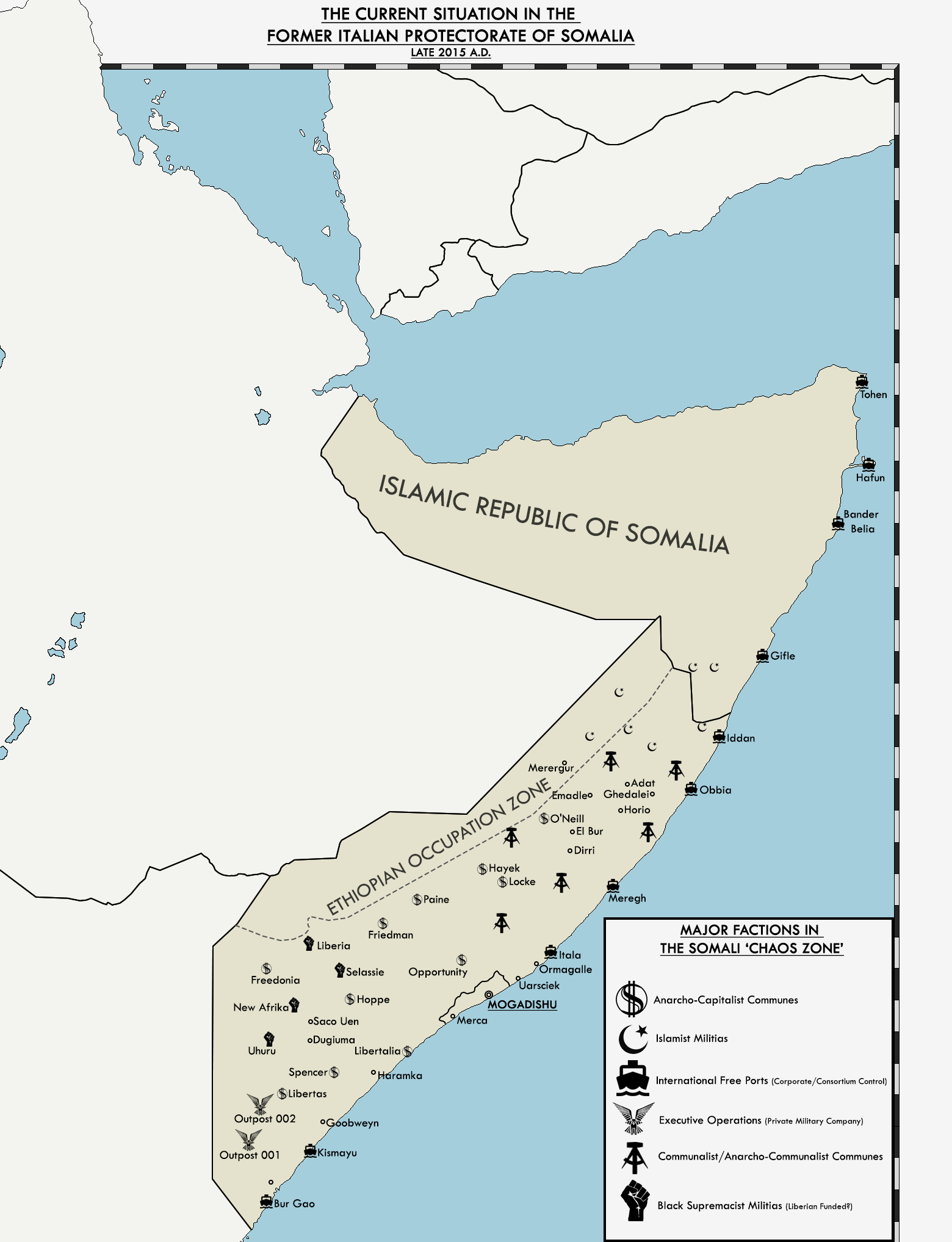
Here's that Somalia map, as promised.

As for the write-up? I figured that I'd integrate it into the African GeoPol updates I got running over on the Revolution! thread, so ya'll might have to wait for those...
Is there a LittleUmbria? An Umbrella?Scotland is NorthNorthumbria, Wales is Westumbria, East Angelia is Eastumbria, Merica is Midumbria, Wessex is Southumbria, Brittany is Britumbria and Ireland is Irumbria.
Lebanon is Monothelite, Copts dominate Egypt and Sudan, Orthodoxy inTurkey. Bosnia is Catholic. Finnish pagans in Finland, Estonia and Russia (!) Slavic pagans in Belarus, Baltic pagans in Lithuania and Belarus. Sweden is Norse pagan. Notice Buddhist Afghanistan, Bangladesh and Maldives and Mongolia, Zoroastrian Turkmenistan and Uzbekistan, Manichean Tajikistan.
Malta and Portugal is Muslim
Moldova and Kazakhstan are Tengri
View attachment 356118 Crusader Kings opening map.
Lebanon is Monothelite, Copts dominate Egypt and Sudan, Orthodoxy inTurkey. Bosnia is Catholic. Finnish pagans in Finland, Estonia and Russia (!) Slavic pagans in Belarus, Baltic pagans in Lithuania and Belarus. Sweden is Norse pagan. Notice Buddhist Afghanistan, Bangladesh and Maldives and Mongolia, Zoroastrian Turkmenistan and Uzbekistan, Manichean Tajikistan.
Malta and Portugal is Muslim
Moldova and Kazakhstan are Tengri
Which opening? 1066? Or 769?
Crusader Kings opening map.
Is that a Hindu Vietnam?
Skallagrim
Banned
Here's that Somalia map, as promised.
Nice! My thoughts immediately turn practical: how to turn this into a workable solution. After looking at it for a while, I've noticed that the seeming hodge-podge of settlements is actually far easier to fit into a less chaotic framework than one might expect. Assuming for the moment that the various ideologically similar settlements can at least stand each other insofar that they're willing to band together loosely, I see only two problems to a coherent territorial settlement: namely the AnCap settlements of Freedonia and O'Neill. Those two are surrounded by Black Supremacists and AnComs, respectively.
-- It's clear that the Islamic Republic of Somalia will tolerate (or is in no position to object to) corporate controlled free ports in its territory. This would allow the entire northeast of the chaos zone, free ports included, to just be annexed to the Islamic Republic with no trouble.
-- If Freedonia and O'Neill are evactuated, then the whole Black Supremacist area could become a territorially contiguous country, as could the whole AnCom area. At the same time, this would then prompt them to recognise the AnCap country in between them. ("we three don't like each other, but we like being conquered by outsiders even less!")
-- The area of Itala and Mergegh could easily be annexed to the already corporate country centred on Mogadishu.
-- Bur Gao and Kismayu could form their own corporate country.
-- The Executive Operations outposts could form the basis for a PMC-owned country.
-- Ethiopia can just outright annex the zone it already controls, except the islamist-controlled areas (which go to the Islamic Republic of Somalia instead.)
It could be that I'm missing something that's part of the backstory, but to me, such a negotiated solution seems to be in everyone's best interests. Every major faction gets its own country (or in the case of the islamists, they get to join the country they are presumably already connected to). Borders are set, and the various parties have reasons to respect those borders. Presto! The Chaos Zone is suddenly far less chaotic, and hopefully a lot more peaceful. With my apologies for butchering your map, I've mad a crude visualisation just to give you an idea of what I have in mind:
Last edited:
Is that a Hindu Vietnam?
I didnt change anything outside of CK2 screen, as I used the former EU4 map (https://www.alternatehistory.com/forum/threads/map-thread-xvii.426654/page-101) as base. Vietnam became Hindu by a very narrow margin, as Hindus were in the south and south had more development than the Mahayana north..
- Status
- Not open for further replies.
Share: