You are using an out of date browser. It may not display this or other websites correctly.
You should upgrade or use an alternative browser.
You should upgrade or use an alternative browser.
Map Thread XV
- Thread starter rvbomally
- Start date
- Status
- Not open for further replies.
CannedTech
Banned
Just wondering does anyone have the latest colour scheme?
Which one? TOASTER or the split-offs?
(I would have uploaded it, but my whacky internet is currently preventing that)
Which one? TOASTER or the split-offs?
If I remember correctly the one I used to use was TACOS, I think.
Which one? TOASTER or the split-offs?
(I would have uploaded it, but my whacky internet is currently preventing that)
toaster is a split-off
Ah yes that´s true, and there were also many Poles in Berlin, I just focused with my basemap on the heartland^^ Sure I can do more interesting ones like these, Zalezsky made Ukraine. Do you have any certain peoples in mind?Wonderful! Only quibble would be that the ruhrpolen might be worth an inset. Any other groups you might do this for?
TheScottishMongol
Banned

Might make a series out of this, might not. Depends if I have time.
Basic premise is a Virgin Earth is populated by fauna and flora from South East Asia, than 50 million years later the actual nations are ISOT'd. Continental drift was frozen whilst the animals and plants expanded outwards, but has continued now that the nations and humans have arrived.
- Northern expansion has been a lot slower than southern expansion. Major efforts are being made to make these footholds self-sustainable, in order to be able to swing into the Americas.
- The Yangtze River is full of agricultural/mercantile city states, and serves as a highway for colonization further inland.
- Burma never recovered from its civil war. Poverty, juntas and famine are their only claim to fame.
- The fertile Ganges Delta, like the Yangtze, contains the most foreign refugees and city-states. Maybe one day they'll unite and form a proper republic, but for now they're too technologically backwards and divided.
- Xindei is the first non-transported nation that fulfills the requirements to be listed as a sovereign state. It was created as a successor state to Thailand and Cambodia, founded on anti-royalist beliefs.
- Thailand hopes to take all of India and to use it as a launch pad into the oil rich Middle East.
- Aceh secured their freedom from Indonesia, but at a significant technological cost. Their colonization efforts have been restricted to the northern tip of Sri Lanka, where border clashes with the Andaman and Nicobar Republic are common.
- The South China Sea dispute has still not been resolved, and without China in the mix, competition for the islands is more heated. Malaysia and Vietnam are butting heads over it.
- Mindanao is a lot less extremist than it used to be, but still isolates itself. Reports of Christian purges are common from refugees escaping the island.
- Indonesia is fighting hard to regain control of these islands, and they're finally winning. Chaos and anarchism, as well as healthy dose of pirating ruled over these islands for the first fifty years.
- Not really West Papua anymore, but they name kinda stuck. Currently going through a detente with Indonesia after years of fairly cold behaviour. They're actually helping the Indonesians reclaim the pirate islands.
- Competition for land down under will be fierce in the following years, but for now the three countries that have staked claims so far are distant enough to not be worried. The Australian Orangutan is quite a sight!
- Biologically and politically regarded as the swing point into Africa.
- A series of practically independent military forts that are only held to Indonesia by semi-regular naval visits. The visits are hard to do with limited oil, however.
I'm not sure if I'm 100% happy with this finished project (or the idea of the fauna and flora being transported), but considering it's the first map I've finished enough to post it is a good start!!
Now that is a cool idea. I've always wished I had some artistry skills so I could get more into speculative evolution.
https://www.alternatehistory.com/forum/attachments/tacos-png.245569/If I remember correctly the one I used to use was TACOS, I think.
here is the latest TACOS I have found, Osheron did have a thread to make some updates, but I think that died months ago.
https://www.alternatehistory.com/forum/attachments/tacos-png.245569/
here is the latest TACOS I have found, Osheron did have a thread to make some updates, but I think that died months ago.
Thank you.
Nice, but there's no way the Orangutans would be around after 50 million years, even in relatively stable conditions. Look at the last 50 million years for evolution. Double that for anywhere outside of Indonesia.
Might make a series out of this, might not. Depends if I have time
Basic premise is a Virgin Earth is populated by fauna and flora from South East Asia, than 50 million years later the actual nations are ISOT'd. Continental drift was frozen whilst the animals and plants expanded outwards, but has continued now that the nations and humans have arrived.
- Northern expansion has been a lot slower than southern expansion. Major efforts are being made to make these footholds self-sustainable, in order to be able to swing into the Americas.
- The Yangtze River is full of agricultural/mercantile city states, and serves as a highway for colonization further inland.
- Burma never recovered from its civil war. Poverty, juntas and famine are their only claim to fame.
- The fertile Ganges Delta, like the Yangtze, contains the most foreign refugees and city-states. Maybe one day they'll unite and form a proper republic, but for now they're too technologically backwards and divided.
- Xindei is the first non-transported nation that fulfills the requirements to be listed as a sovereign state. It was created as a successor state to Thailand and Cambodia, founded on anti-royalist beliefs.
- Thailand hopes to take all of India and to use it as a launch pad into the oil rich Middle East.
- Aceh secured their freedom from Indonesia, but at a significant technological cost. Their colonization efforts have been restricted to the northern tip of Sri Lanka, where border clashes with the Andaman and Nicobar Republic are common.
- The South China Sea dispute has still not been resolved, and without China in the mix, competition for the islands is more heated. Malaysia and Vietnam are butting heads over it.
- Mindanao is a lot less extremist than it used to be, but still isolates itself. Reports of Christian purges are common from refugees escaping the island.
- Indonesia is fighting hard to regain control of these islands, and they're finally winning. Chaos and anarchism, as well as healthy dose of pirating ruled over these islands for the first fifty years.
- Not really West Papua anymore, but they name kinda stuck. Currently going through a detente with Indonesia after years of fairly cold behaviour. They're actually helping the Indonesians reclaim the pirate islands.
- Competition for land down under will be fierce in the following years, but for now the three countries that have staked claims so far are distant enough to not be worried. The Australian Orangutan is quite a sight!
- Biologically and politically regarded as the swing point into Africa.
- A series of practically independent military forts that are only held to Indonesia by semi-regular naval visits. The visits are hard to do with limited oil, however.
I'm not sure if I'm 100% happy with this finished project (or the idea of the fauna and flora being transported), but considering it's the first map I've finished enough to post it is a good start!!
TheScottishMongol
Banned
Nice, but there's no way the Orangutans would be around after 50 million years, even in relatively stable conditions. Look at the last 50 million years for evolution. Double that for anywhere outside of Indonesia.
They are, presumably, descended from Orangutans and were named "Australian Orangutans" for their resemblance to modern Orangutans.
Gian
Banned
Might make a series out of this, might not. Depends if I have time
Basic premise is a Virgin Earth is populated by fauna and flora from South East Asia, than 50 million years later the actual nations are ISOT'd. Continental drift was frozen whilst the animals and plants expanded outwards, but has continued now that the nations and humans have arrived.
- Northern expansion has been a lot slower than southern expansion. Major efforts are being made to make these footholds self-sustainable, in order to be able to swing into the Americas.
- The Yangtze River is full of agricultural/mercantile city states, and serves as a highway for colonization further inland.
- Burma never recovered from its civil war. Poverty, juntas and famine are their only claim to fame.
- The fertile Ganges Delta, like the Yangtze, contains the most foreign refugees and city-states. Maybe one day they'll unite and form a proper republic, but for now they're too technologically backwards and divided.
- Xindei is the first non-transported nation that fulfills the requirements to be listed as a sovereign state. It was created as a successor state to Thailand and Cambodia, founded on anti-royalist beliefs.
- Thailand hopes to take all of India and to use it as a launch pad into the oil rich Middle East.
- Aceh secured their freedom from Indonesia, but at a significant technological cost. Their colonization efforts have been restricted to the northern tip of Sri Lanka, where border clashes with the Andaman and Nicobar Republic are common.
- The South China Sea dispute has still not been resolved, and without China in the mix, competition for the islands is more heated. Malaysia and Vietnam are butting heads over it.
- Mindanao is a lot less extremist than it used to be, but still isolates itself. Reports of Christian purges are common from refugees escaping the island.
- Indonesia is fighting hard to regain control of these islands, and they're finally winning. Chaos and anarchism, as well as healthy dose of pirating ruled over these islands for the first fifty years.
- Not really West Papua anymore, but they name kinda stuck. Currently going through a detente with Indonesia after years of fairly cold behaviour. They're actually helping the Indonesians reclaim the pirate islands.
- Competition for land down under will be fierce in the following years, but for now the three countries that have staked claims so far are distant enough to not be worried. The Australian Orangutan is quite a sight!
- Biologically and politically regarded as the swing point into Africa.
- A series of practically independent military forts that are only held to Indonesia by semi-regular naval visits. The visits are hard to do with limited oil, however.
I'm not sure if I'm 100% happy with this finished project (or the idea of the fauna and flora being transported), but considering it's the first map I've finished enough to post it is a good start!!
That's actually great.
Why don't you also do one where the Iberic states get ISOTed to a Virgin Earth:
Basically:
-all of Spain and Portugal
-all of Latin America (only the Spanish and Portuguese-speaking countries)
-Iberian Asia-Pacific (Philippines, East Timor, Goa, Macau, Palau, Guam, NMI, and Micronesia)
-Equatorial Guinea and the former Portuguese Africa (Guinea-Bissau, Cape Verde, Sao Tome and Principe, Angola, and Mozambique)
Bytor
Monthly Donor
and how Pimera doesn't have much water here.
There are precedents, though. Erie, PA being one of them. That little tail to Pimeria could be a later grant from the federal government to give it a port.
Bytor
Monthly Donor
After creating my map about the german settlement and presence in Europe:
http://arminius1871.deviantart.com/art/Germans-in-Eastern-Europe-map-683122099
I created one about the Poles as well:
http://arminius1871.deviantart.com/art/Polish-settlement-and-presence-in-Europe-689990629?ga_submit_new=10:1498997514
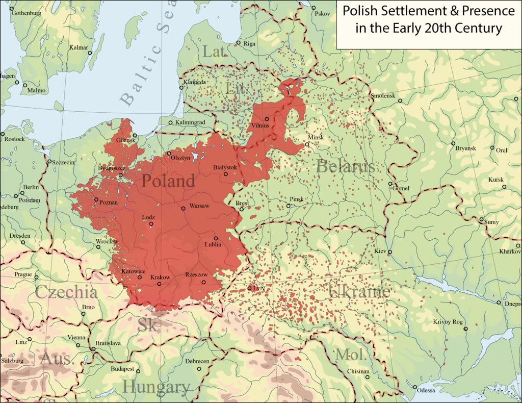
I hope you like it!
Arminius1871
How the heck do you do your maps so quickly? Merely a week to do a topo that detailed and complex? I don't think I could do that even if i spent 8 hours a day at it!
How the heck do you do your maps so quickly? Merely a week to do a topo that detailed and complex? I don't think I could do that even if i spent 8 hours a day at it!
I would guess that's an outside basemap.
Bytor
Monthly Donor
Over on DeviantArt he said it took him a week to make it. http://arminius1871.deviantart.com/art/Europe-topographical-map-682407330I would guess that's an outside basemap.
The former United States at the end of my Kaiserreich Presidents list here:

Notes: Alaska is Canadian, and Hawaii is a Japanese Sphereling
Notes: Alaska is Canadian, and Hawaii is a Japanese Sphereling
I wasn't talking about ports or salt water. Besides, Pennsyvlania paid New York for the Erie Triangle. Pimera here is too deserty to be useful. Actually gets me to thinking about the Nevada borders and how they took land from the nearby territories after it gained statehood.There are precedents, though. Erie, PA being one of them. That little tail to Pimeria could be a later grant from the federal government to give it a port.
Surprised they went with West Texas over Soth Texas.
Before the alt-US states train leaves the station, here's the United States from my map a few pages back, with all the state names and abbreviations, circa 1961.

AB - Assiniboia
AC - Acadia
AE - Apacheria
AH - Arapaho
AL - Alabama
AP- Appalachia
AT - Athabaska
AY - Alyeska
AZ - Arizona
CA - California
CH - Cheyenne
CL - Carolina
CT - Connecticut
CU - Cuba
DE - Delaware
DG - Douglass
DK - Dakota
FL - Florida
FR - Fremont
GA - Georgia
GT - Grant
HR - Huron
IL - Illinois
IN - Indiana
JF - Jefferson
KN - Kanawha
KS - Kansas
KY - Kentucky
LA - Louisiana
MA - Massachusetts
MB - Manitoba
MD - Maryland
ME - Maine
MI - Michigan
MO - Missouri
MS - Mississippi
NB - New Brunswick
NE - Nebraska
NH - New Hampshire
NJ - New Jersey
NY - New York
OH - Ohio
OK - Oklahoma
OR - Oregon
PA - Pennsylvania
PN - Panama (not pictured)
QC - Quebec
RI - Rhode Island
SH - Shoshone
SN - Sonora
SQ - Sequoyah
TN - Tennessee
TX - Texas
UT - Utah
VA - Virginia
VT - Vermont
WA - Washington
WI - Wisconsin
AC - Arctic Territory
AN - Antarctic Territory (not pictured)
HU - Hudson Territory
UN - Ungava Territory
AN - Antarctic Territory (not pictured)
HU - Hudson Territory
UN - Ungava Territory
Last edited:
Emperor-of-New-Zealand
Kicked
Before the alt-US states train leaves the station, here's the United States from my map a few pages back, with all the state names and abbreviations.
I do have to wonder - seeing as the US seemingly grabbed Canada relatively early in this map, would Alaska have ever made it to statehood?
- Status
- Not open for further replies.
Share: