Map Thread XIX

Status
Not open for further replies.
Roma Invicta: 12 Romes

These are pretty ASB, and I just kinda went with whatever popped up into my head, so don't judge it too harshly.


12Romes_Progress.png


Here is a bigger version if it's hard to read:
12Romes_Final.png


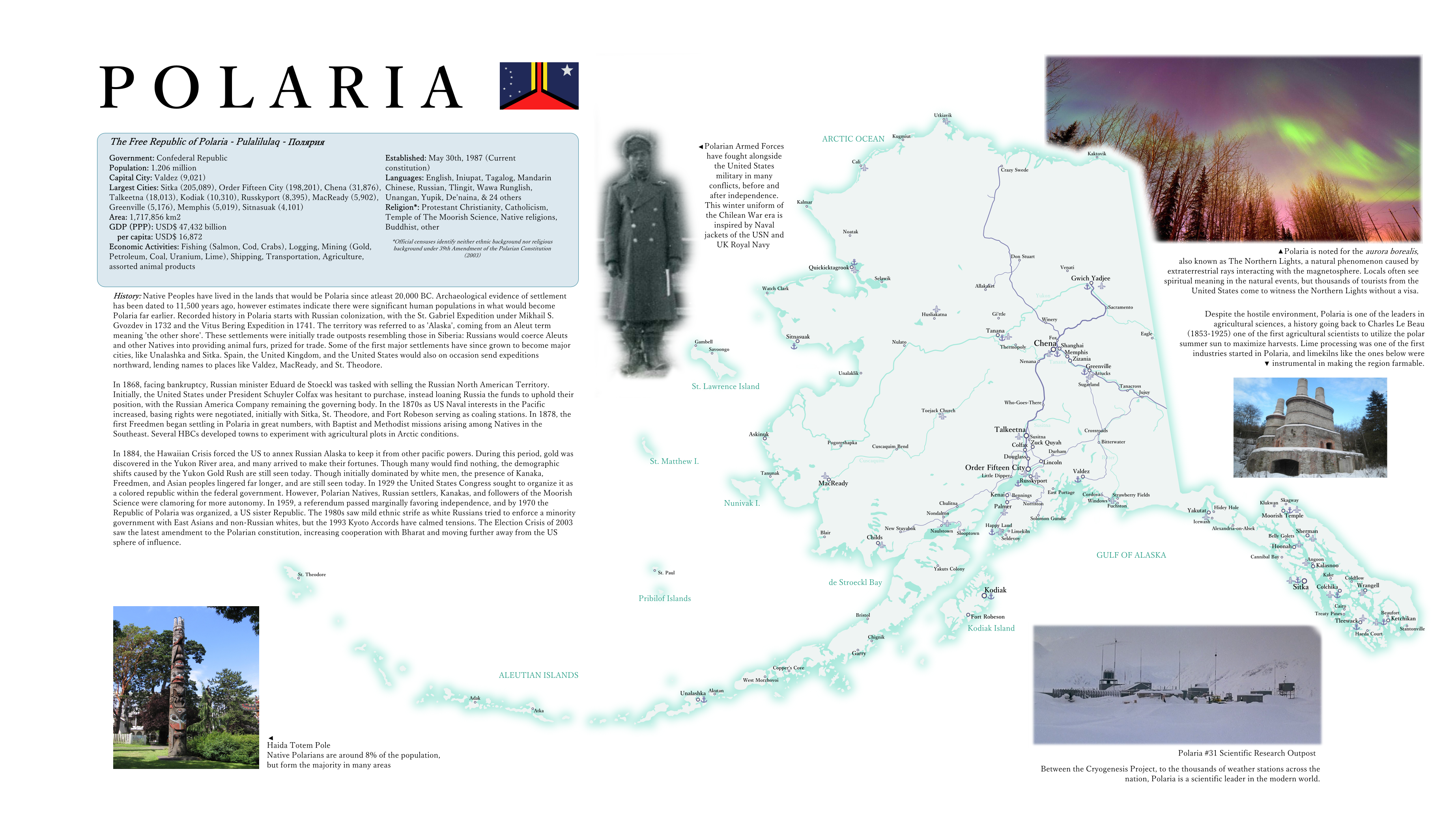
Here's a WIP, same scenario as the Polwanks. If I complete it, it'll be an electoral map of the Polish-Lithuanian Federation around the year 1900, for the time being I'm still adjusting the borders of the base map I'm using

upload_2019-9-29_21-8-9.png


Dark Green - Federal Party. Have gotten a lot of bad press for their abuses of power, but their miltary reforms made them popular again in coastal areas after the Swedish invasion in the War of the Turkish Succession.
Yellow - Nowa Szlachta. Derisively called the Rich Peoples' Party by their opponents, and there's definitely some truth to that.
Gold - Constitutional Democrats. All that was left of the Constitutional Party after the Federals and Liberals left. Neither liberal nor authoritarian, but they still tend leftwards on the other axes of the political compass.
Blue - Liberal Party. They believe in encouraging social progress, and in a limited government. Very popular in areas that have industrialized well, not so popular everywhere else.
Magenta - Agrarian Party (formerly the Peasants' Parliament Party, they changed the name because the Peasants' Parliament got renamed the People's Parliament after the Commonwealth became the Federation)
Pale Brown - Polish National Party. Their platform consists of intense patriotism, vague promises, and either arguing for a weaker Federation with more autonomy for the Republics or a strong Federation where Poland has more influence. This is not too different from similar parties in other republics, and once in a while one of these parties does win a Voivodeship somewhere
Dark Brown - Kashubian National Party. They want Kashubia to be its own Republic. They're especially popular now that Lusatia is a Republic, since it raises questions about just what the population threshold for becoming a Republic is - a question that wasn't answered in the Constitution itself.
Red - The Socialist Party
Grey - The German People's Party. Popular in German-majority areas, they tend to just promote German culture and advocate for things like making German one of the official languages of the Federation, sometimes for greater autonomy for German-majority areas, but the more extreme members of the party have advocated for secession in the past.
Pale Green - Lusatian National Party. Used to be a minor party in Silesia advocating for greater autonomy for the Sorbian-majority areas of Silesia, now they've got a brand new Republic under their control
Greyish Blue - Tikun Olam Party. Especially popular in Jewish-majority areas, but with a decent amount of supporters elsewhere too, this is a party that was formed by Jewish activists who split from the Socialist and Liberal Parties. While the Tikun Olam Party doesn't advocate for full socialism, their platform is based on the ideal they named themselves after. They advocate for things like a strong welfare system and a justice system focused on rehabilitation, and in places like the Krakow Voivodeship (and the City of Krakow itself), the beginnings of environmentalism

Thoughts?
 
Isn't it a polish-bohemian confederation ?

Not quite. It looks that way right now because I've only done part of it yet, and the Czech Republic was one of the areas on the base map I used where the borders were easiest to adjust, but its actually a successor state to a Polish-Lithuanian Commonwealth that went Protestant, gained the Kingdom of Bohemia after this timeline's version of the Thirty Years' War as a constituent kingdom of the Commonwealth, and eventually transitioned to a democracy. Bohemia is one of the major constituent republics of the Federation, however, and it was one of the founders alongside Poland, Lithuania, Prussia, Silesia, Courland, and Pomerania. Moravia was split off from Bohemia, just as Galicia was split off from Poland and Rusynia (*Belarus) was split off from Lithuania, so that the average population of the constituent republics would be lower. Bohemia is also one of the most - and best - industrialized regions of the Federation, and when we're just discussing the republics, the best industrialized period
 
A ridiculous broken up US map.


Republic of New England -
Like Canada but without powerful provinces and a humongous legislature. Vermont independence is debated every other week.
Federative Republic of America - Ruled out of Philadelphia, a bit like OTL US but less dysfunctional and more power is held by the federation government. New York dominates the legislature while Washington DC has been elevated to statehood. Also holds Puerto Rico and the USVI.
Southron Republic - They aren't Confederates. They promise. Plus, Tim Scott is Vice President.
United States of America (Minneapolis Government) - The successor to the old federal government. A middling power.
Republic of the Pacific - Basically just California with Hawaii and the old American Pacific territories.
Columbian Federation - A real mess. Wracked by tension between Ammon Bundy-esque anti-government types and the booming, hip cities of the Pacific Coast.

accreditationzone.png

 
This. I like this.

Can I suggest that you do one of these but for the Khoisan people or another remnant population?

See, I've had requests for this sort of thing, but the medium lends itself more towards established states with some sort of known history rather than smaller populations.

It's difficult to make multiple maps for the Khoisan with unique divergences without leaning on more popular or well known African states and cultures.

I'd suggest you try it out though! I have a template I can provide though it's quite basic.
 
Last edited:
Here are the provinces for an independent parliamentary Oregon Country I might be making a few posts on the Wikibox thread about. Sorry about the quality of the borders, I did some dumb shit while making it and I'm too lazy to fix it

VC = part of Vancouver province and NT = part of the Northern Territory btw

provinces.png
 
BIG map time
4jckopuxjqp31.png

I posted this map on r/IM like three hours ago and it only has twenty upvotes, so now I'm posting it here too in the hopes that it'll get some more of the attention that I desperately crave.

This map is a remake of an old map I made about a year and a half ago. The main point of divergence is the Romans winning the Battle of Yarmouk and killing Khalid ibn al-Walid, resulting in the Caliphate expanding eastward and Persia being split between an islamic part south of the Zagros Range and the Byzantines conquering, converting, and quickly loosing control of the part north of the Zagros. Islam then spreads through India to China (Serica).

Another sub-PoD is Otto II conquering half of West Francia, creating a much bigger and badder Empire of the Germans. Fun ensues.

Also I accidentally made the Incas way bigger than they should be. This map was initially meant to depict 1500 AD, but I changed it midway through to be 1300 AD in stead, so there might be a few mistakes that seem like they shouldn't be on a map this early. That's why.
Damn this is amazing
 
BIG map time
4jckopuxjqp31.png

I posted this map on r/IM like three hours ago and it only has twenty upvotes, so now I'm posting it here too in the hopes that it'll get some more of the attention that I desperately crave.

This map is a remake of an old map I made about a year and a half ago. The main point of divergence is the Romans winning the Battle of Yarmouk and killing Khalid ibn al-Walid, resulting in the Caliphate expanding eastward and Persia being split between an islamic part south of the Zagros Range and the Byzantines conquering, converting, and quickly loosing control of the part north of the Zagros. Islam then spreads through India to China (Serica).

Another sub-PoD is Otto II conquering half of West Francia, creating a much bigger and badder Empire of the Germans. Fun ensues.

Also I accidentally made the Incas way bigger than they should be. This map was initially meant to depict 1500 AD, but I changed it midway through to be 1300 AD in stead, so there might be a few mistakes that seem like they shouldn't be on a map this early. That's why.
A refreshing take, I must say, on a Muslim-focused POD that doesn't immediately result in a Muslim-screw.
 
Last edited:
Top
Status
Not open for further replies.
Top