We have a poll to pick the best maps from the recent B_Munro cover contest. If you are interested in voting please pop on over to the thread.
A Link to the Thread
A Link to the Thread
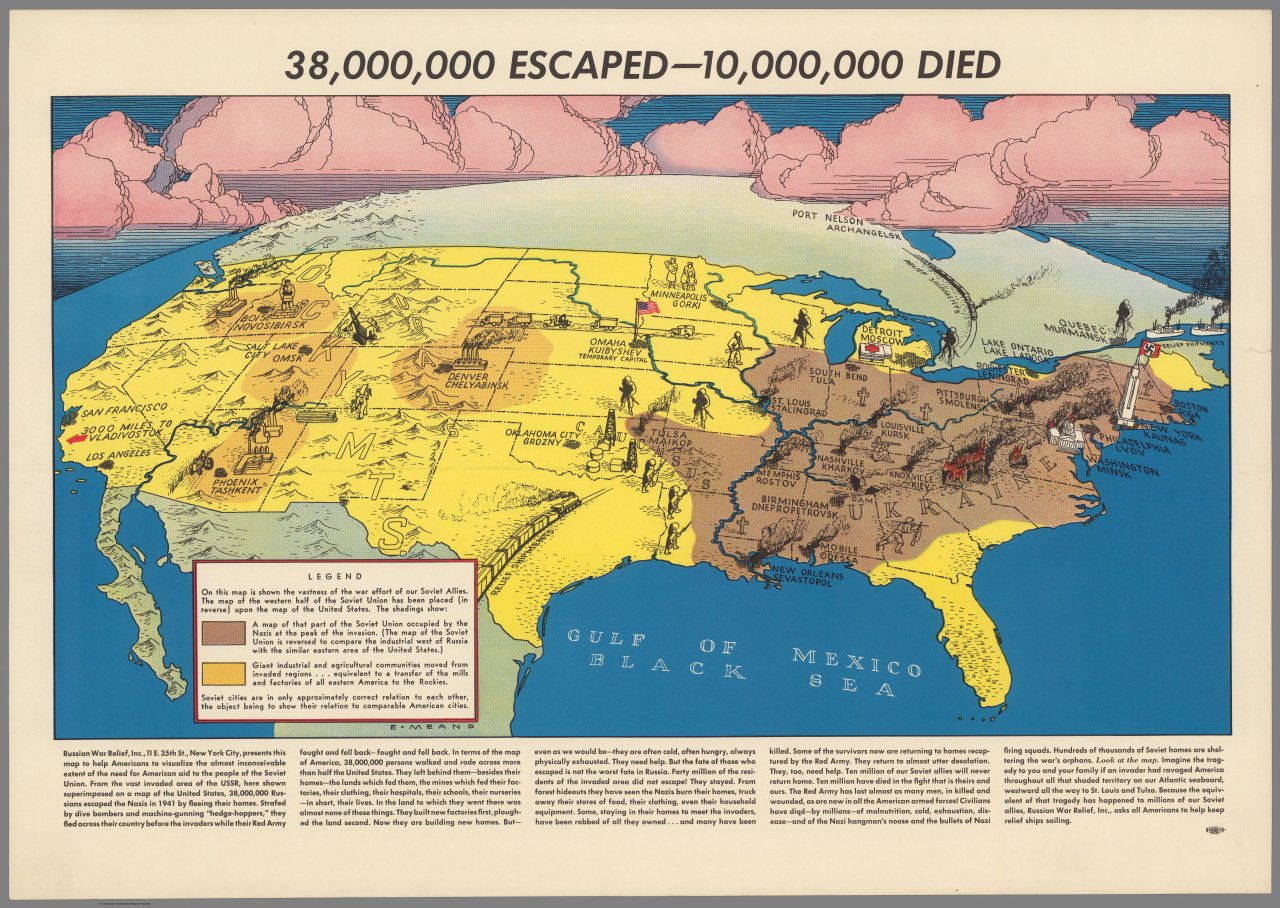
Here is a map published in 1943 which compared the German occupation of the USSR with the equivalent happening to the US, in order to illustrate the scale of the invasion to American readers.
@Selvetrica holy moly. Love it.
Hint to everyone: you can like a map as many times as you like, you just have to unlike it multiple times as well.
Ah, clearly you've never heard of sockpuppets.
(/s)
I can't even make toast.Did you make this or is this legit?
Stunning work! I love the meticulously drawn lines of battle and arrows showing army movement. And the contour lines and city streets are incredible! Great job.Hi, not sure if this fits here but I made two maps for the American Civil War in HOI4's Kaiserreich mod
Stunning work! I love the meticulously drawn lines of battle and arrows showing army movement. And the contour lines and city streets are incredible! Great job.
This is amazing! I love Kaiserreich and would LOVE to see more of this type of stuff. Great work!Hi, not sure if this fits here but I made two maps for the American Civil War in HOI4's Kaiserreich mod
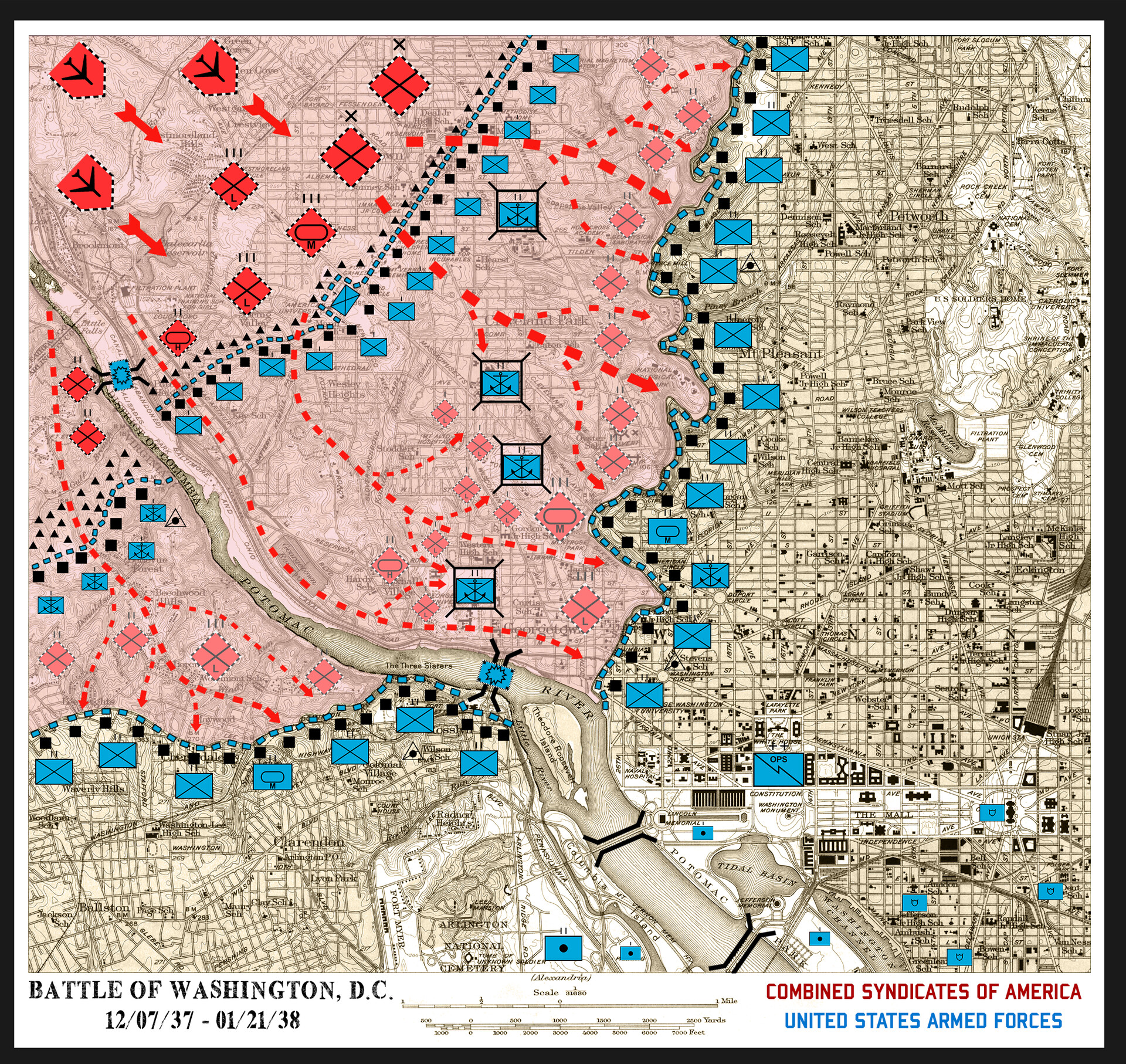
With their flanks secure, the US can meet the CSA head on in the outskirts of the city and then make a fighting retreat to the city proper if need be. Marine and Infantry companies man the forward fortified line on both sides of the Potomac while Georgetown University, the Naval Observatory, the Washington Cathedral and the Bureau of Standards HQ have all been made into heavily fortified strong points by Marine Corps Combat Engineers. Two final defensive lines have been established along the length of Rock Creek and just forward of Arlington National Cemetery and several artillery batteries have been set up at the Lincoln Memorial, the Jefferson Memorial and near the Cemetery.
Facing the handful of US Battalions is several regiments of CSA forces, mainly light infantry supported by a Heavy Armour Battalion, Air Support and a Medium Armor Regiment while the overlay of red is the projected ground which they are likely to take, or so thinks US Command.
What’s the worst thing about fighting in the Rockies?
Is it the forests, where your life could be ended in a single moment by a bullet, a mine, by the howling impact of an artillery shell before you even saw any of it coming?
Is it the snow, which saps your strength as more and more of it falls and melts over the course of a week and leaves those tanks and trucks you were depending on for support bogged down in a thick soup of mud?
Is it the terrain itself? The imposing mountain peaks and sharp sudden falls that snap the bones in your legs if you’re lucky and caves in your skull if you're not.
Perhaps it’s the enemy itself? The Feds who had a good year to map out the terrain, dig their bunkers into the Earth so well that our big guns did next to nothing to them, and plan their little kill-zones around the only places they knew we could advance as we came to take Denver.
No, it’s none of these.
It's the air.
Air that leaves men who fought across the deserts of Arizona and Utah without complaint keeling over and heaving from exhaustion. Air that leaves you fatigued and immobile and useless, just a fraction too slow to leap to cover when the Feds open up with their guns and mortars and tear the replacements you’ve known for two days to pieces and leave them as crimson angels in the snow.
Air that you can never get enough of as you fight battles at elevations of four thousand feet in one week and nearly triple that the next. Your lungs beg for you to just stop, take a moment and just let them work yet there’s never any time to do it, not when the Captain comes to tell the company of their next objective and you’re left cursing MacArthur, Reed, Long and every other miserable sonofabitch who decided this war was necessary.
And then you die, with a whispered curse on your lips, because when in the hell would your lungs ever have had enough air to yell.
That was the worst thing about fighting in the Rockies.
That was Operation Glacier.
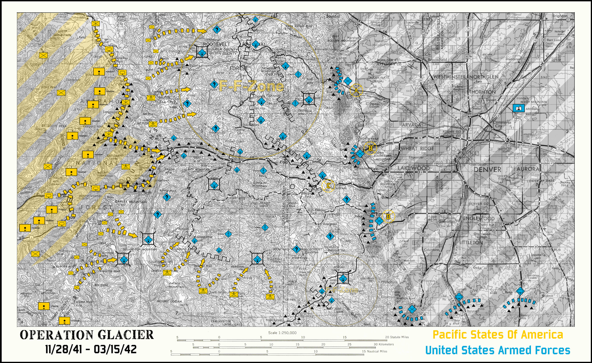
PSA forces, under the command of General Alexander ‘Sandy’ Patch continue their advance across the Western United States, aiming to take the temporary capital of the Federalist forces in Denver, Colorado under the banner of the widely encompassing and aptly named Operation Glacier. Facing them are US Mountain forces that are heavily dug in and camouflaged in the Rocky Mountains.
The key to the PSA advance strategy is the extremely liberal use of Artillery, leading to certain sections of the advance to be labelled a Free Fire Zone, as designated by intelligence gathered from the newly deployed and experimental Ranger Battalions supporting the flanks of the Armour and Motorised Battalions making their way down the few roads that cut through the mountains.
But even with all of this overwhelming use of heavy firepower, the US Forces bog the operation down for almost two months longer than anticipated with hundreds of casualties to go with every mile gained with Denver proving similarly difficult to assault in the months afterwards.

I will take it as a condolence but not a condonationAuthors note: This is not meant to be an ideal America. This is meant to be the exact opposite of the ideal- a world where America is unquestionably the big bad. Do not take this map as a condolence of anything that takes place within it.
")
Ah fuck, that's what you get for writing a disclaimer less than an hour after you wake up.I will take it as a condolence but not a condonation
Hehe. It's an enjoyable typo though. Takes the edge off this hangover of mine.Ah fuck, that's what you get for writing a disclaimer less than an hour after you wake up.
Ah, hangovers suck. My condolences, I can't condone that much drinking however.Hehe. It's an enjoyable typo though. Takes the edge off this hangover of mine.
This is a zoogeographic map of the distribution of an alternate genus of giant rats (Auromys) inhabiting the alternate volcanic archipelago of the Aurora Islands, in front of the South African atlantic shore.
View attachment 562715
The Auromys giant rats would have evolved from an African rodent ancestor which would have rafted to the primitive single volcanic island a few million of years ago and due to the isolation and lack of competition would have evolved into a gigantic form, becomig the top predator of the island. After the collapse of the central Great Caldera, the primitive island was split in several new islands which continued to change due to volcanic activity. The different subpopulations of the primal Auromys became isolated between them and evolved into new separate species.
At the moment of the arrival of the European explorers by the mid-16th century, there were at least twelve different species of giant rats inhabiting the Aurora Islands. However, the introduction of invasive species like feral cats or dogs decimated the extant species until the South African administration passed laws of protections of the giant rats during the first half of the 20th century. It was too late for at least one of the species, the Juliana Island giant rat, which was declared extinct in 1932.
The remaining eleven species have been also more or less affected by the human settlement: the subspecies of the North Eliana giant rat inhabiting Lacena island (Auromys nigra lacenae) was already extirpated by 1890, and the other subspecies inhabiting Verena island (Auromys nigra verenae) is believed to have been reduced to 20 or 30 adults; the Orianna giant rat is reduced to three separate tiny subpopulations and its risk of global extinction was so high that the local government established a semi-wild breeding population in the uninhabited Lorena island; the status of the two species of Arilena island, the most populated and developed island of the archipelago, is critical as well, in fact the lowland species has not been sighted since 1982 and might be extinct; and finally the Eudora island species is currently extinct in the wild but started to be reintroduced. As a positive note, the Alina island species, which was believed to be extinct since 1947, was rediscovered in the central hill of the island in 2011 and despite its low numbers, the tiny population seem to be relatively safe.
The zoologists believe that a 13th species existed in Adara island before the European arrival, but the accidental introduction of the neighbouring species of Lara island (today called the Great Caldera giant rat, as Lara is the main remainder of the collapsed, submerged caldera) caused the extinction of the yet to be described Adara island giant rat because of direct competition (the Great Caldera giant rat is the largest species of all the Auromys species).
So is Charlottania a french speaking state or is it British?Traditional Canada color is Charlottania, Traditional US color is Appalachia. In the Northeast, Charlottania has legal dominion over those small countries of New England (+New York and Haudenosaunee). Florida is Charlottania's Swampland folly, and it's only switched from basically a series of military outposts, small plantations, and runaways of various kinds hiding in swamps, to a tourist trap dominated by business interests.
Grey states are everyone else, the Anahuac Federation, Cuba, The Bahamas, etc.
I had written a write up earlier, but computer crashed before I could post. In retrospect, as much as this is US and Canada swapped places there are elements of French, Argentine, and Australian history to this USA