You are using an out of date browser. It may not display this or other websites correctly.
You should upgrade or use an alternative browser.
You should upgrade or use an alternative browser.
Map Thread XIV
- Thread starter MorningDew
- Start date
- Status
- Not open for further replies.


For the second map, the key is as follows:
Red: "Worker's Republic"
Dark Blue: "Democracy"
Light Blue: "Limited Democracy"
Yellow: "One-Party State"
White: "No Self-Rule"
Violet: "Absolute Monarchy"
Listed in that order.
I don't know about you, but I've never seen a more impartial and apolitical map.
Red: "Worker's Republic"
Dark Blue: "Democracy"
Light Blue: "Limited Democracy"
Yellow: "One-Party State"
White: "No Self-Rule"
Violet: "Absolute Monarchy"
Listed in that order.
I don't know about you, but I've never seen a more impartial and apolitical map.
The Great Ireland of Britain and Kingdom
I now know what I need to put as my location...
Isaac Beach
Banned
There is an infinite number of universes, but in not one of them does Argentina own the Falklands.
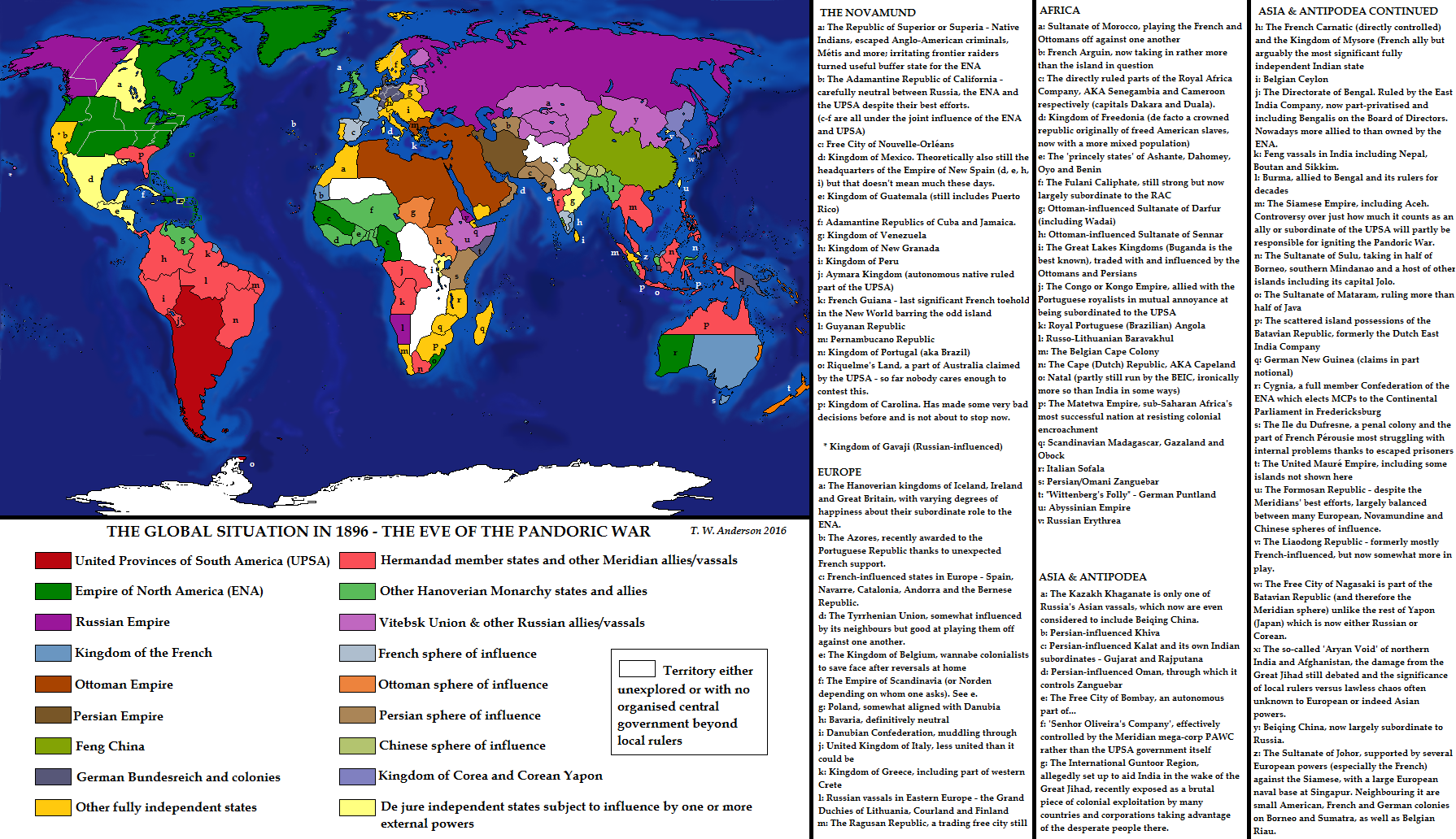
Great map!Finally a LTTW world map!
Any similarities in style to that great cartographer Mr B. Munro are of course coincidental
I must say that I do like the look of displaying Britain in green. I believe it was colored that way in some atlases I had a while back and I've enjoyed it since then.
The Kingdom Falklands Of Argentina Britain, Ireland, And Nothern Cumberbatch... And Steven! [am i doing it right?]
Upvoteanthology
Donor
You forgot Uttar Pradesh.United Kingdom of the NORTH

this was kinda fun to work on. I might continue with the other directions
Chicxulub
Banned
I'm working on a more detailed Q-BAM map of this, including Counties and other second-level divisions. I will also be including Stanistan.United Kingdom of the NORTH
this was kinda fun to work on. I might continue with the other directions
Last edited:
You forgot Uttar Pradesh.
Also Beijing (Northern Capital), Hubei (North of the Lake) and North Ossetia.
And North Sumatra, North Kalimantan, North Sulawesi, North Maluku, the Northern and North Caucasus economic regions, Northern Borders, and Norra Sverige.Also Beijing (Northern Capital), Hubei (North of the Lake) and North Ossetia.
Of course, we can't exclude the northern half/region of every other country, too!And North Sumatra, North Kalimantan, North Sulawesi, North Maluku, the Northern and North Caucasus economic regions, Northern Borders, and Norra Sverige.
Baja is just 'Baja California' and Baja California Sur is its own thing. Kind of like how there's no East VirginiaAnd Baja California Norte.
Minor point of note: The Mauré seem to have a colour, but not be in the legend.Finally a LTTW world map!
Any similarities in style to that great cartographer Mr B. Munro are of course coincidental
And North Sumatra, North Kalimantan, North Sulawesi, North Maluku, the Northern and North Caucasus economic regions, Northern Borders, and Norra Sverige.
...und Nordrhein Westfalen.
Which would also be part of the Great Western Union.
.
Upvoteanthology
Donor
Same with the Northwest Territories....und Nordrhein Westfalen.
Which would also be part of the Great Western Union.
.
Chicxulub
Banned
What I'll do when I add other countries is have regions with multiple direction names in them be disputed, with the first direction in the name owning it. So North Rhine-Westphalia would be owned by the North, but claimed by the West....und Nordrhein Westfalen.
Which would also be part of the Great Western Union.
.
- Status
- Not open for further replies.
Share: