You are using an out of date browser. It may not display this or other websites correctly.
You should upgrade or use an alternative browser.
You should upgrade or use an alternative browser.
Map Thread XII
- Thread starter Baconheimer
- Start date
- Status
- Not open for further replies.
First Post on Maps Thread
Hello everyone") This is my first post. I'd love input towards my art; here are two pieces.
This is my first post. I'd love input towards my art; here are two pieces.
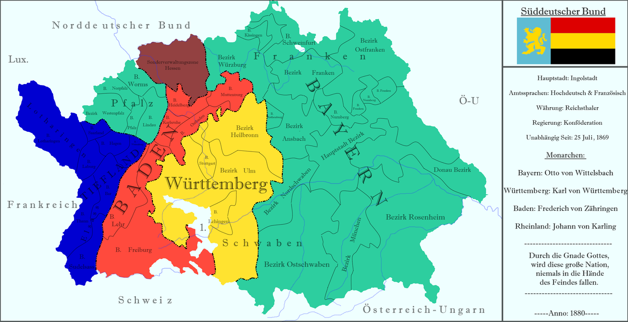
South German Confederation:
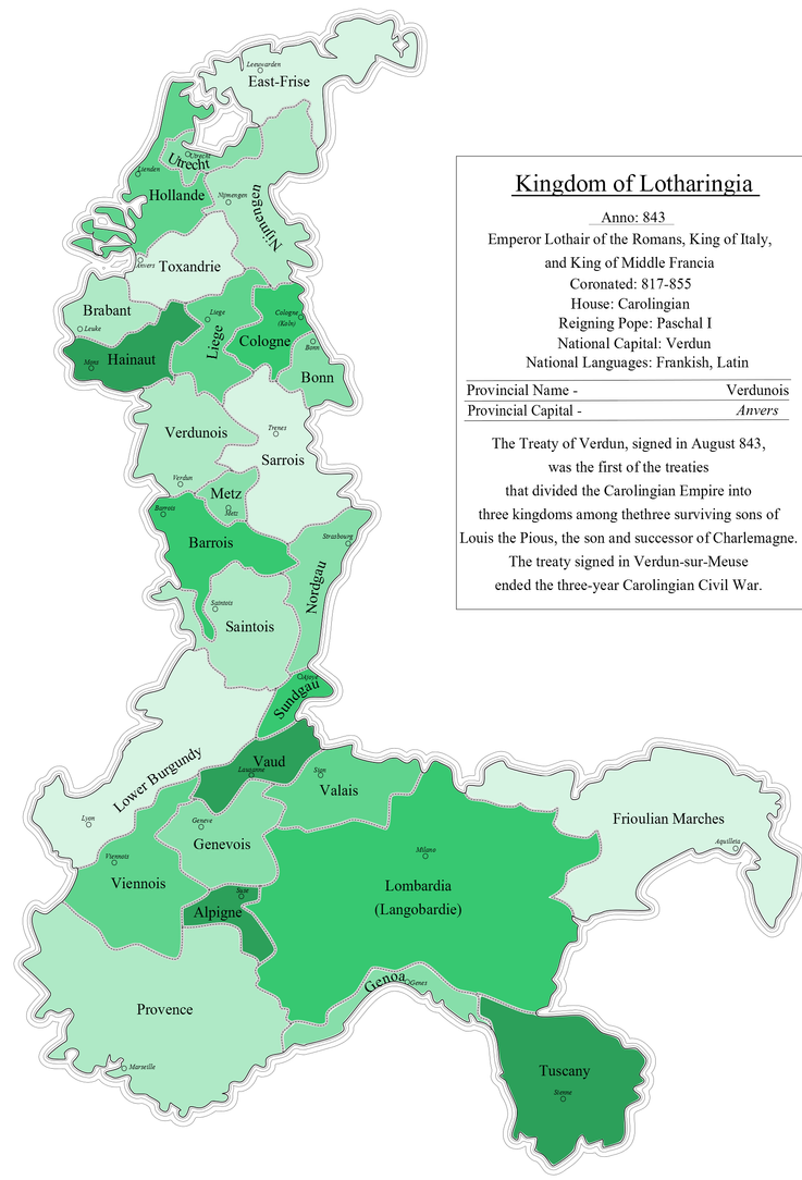
and Lotharingian Kingdom:
If you'd like to see more of my art visit me at http://zalezsky.deviantart.com/
Hello everyone
This is my first post. I'd love input towards my art; here are two pieces.South German Confederation:
and Lotharingian Kingdom:
If you'd like to see more of my art visit me at http://zalezsky.deviantart.com/
Nasser with the Axis. Great. What of Palestine?
When will China turn from the Allies?
Who has the better tech? Or Nuclear weapons for that?
Popular cultural?
Egypt isn't offically aligned with the Axis, but they do buy weapons and SS "Volunteer" Officers have been spotted amongst the ranks. China isn't really interested in siding with the Reich, although Hitler does make overtures. Memories of fighting the Reich's "ally" is still fresh in the minds of many Chinese. They prefer to instead to profit from the Allies ongoing conflict and snag little bits of the USSR when noone is looking, Tibet however remains a point of friction between Nanjing and New Dehli.
Technology wise the Reich is advanced in some areas, but technologically stunted in many others. It's rocketry programs are more advanced than the Allies in many respects, but sudden the death of Von Braun in 1946 (during a bombing raid by the Allies against his rocket facilities) did stunt this somewhat. German medical science is also quite advanced in some fields (due to numerous human test subjects available) and their chemical warfare is second to none. Nuclear weapons however are laughed down by the German scientific community as an impossiblility, despite very convincing rumors that the Allies have created something.
I don’t know what’s ASB about it; America’s still not big enough.

I can shee youu’v taken to my teachinsh well. However. I don’t think that thish is neshisharily the only definishion.
Never laughed so hard at a post in my life! THERE CAN ONLY BE ONE!
Alex Richards
Donor
Hello everyone
South German Confederation:
and Lotharingian Kingdom:
If you'd like to see more of my art visit me at http://zalezsky.deviantart.com/
Well, that's an absolutely fantastic first post. Have you seen the Map of the Fortnight competition?
I Haven't heard of it no, Is it on this forum? I'll look it up if soWell, that's an absolutely fantastic first post. Have you seen the Map of the Fortnight competition?
I Haven't heard of it no, Is it on this forum? I'll look it up if so
Yes it is, it's in this very subforum. You should participate, it can be very fun. By the way, it's good to see you showing your work here, too!
Krall
Banned
I Haven't heard of it no, Is it on this forum? I'll look it up if so
Yes it is - I'm the guy who runs it! Long story short, it's a series of map contests, with each contest round lasting two weeks (a fortnight) and having a specific challenge ("Make a map showing the aftermath of a natural disaster", "Make a map showing a country's system of client states", etc.). Anyone can enter by posting a map that meets the round's challenge in that round's entry thread. The winner is determined by a simple poll in a voting thread. All threads are posted here, in the Maps and Graphics forum.
You can find links to the Main Thread and the current entry and voting threads (for the current fortnight's challenge and the previous fortnight's challenge, respectively) in my signature, though the explanation of the structure and rules at the beginning of the Main Thread are a bit out of date, and I'm afraid the current round will be the last one for this year (we take a break over Christmas), so unless you can make a map that meets the current challenge requirements in the next couple of days, I'm afraid you'll have to wait until January to take part.
Feel free to discuss the contest and ideas for future challenges in the main thread, though, and if you have any questions at all please feel free to post them in the Main Thread or PM me.
Hello everyone
South German Confederation:
-snip-
Some of the Bezirk borders are a bit odd (although coming from the HRE there had been much weirder borders OTL) but a nice little map.
Handful of typos though.
Yes it is, it's in this very subforum. You should participate, it can be very fun. By the way, it's good to see you showing your work here, too!
Yes it is - I'm the guy who runs it! Long story short, it's a series of map contests, with each contest round lasting two weeks (a fortnight) and having a specific challenge ("Make a map showing the aftermath of a natural disaster", "Make a map showing a country's system of client states", etc.). Anyone can enter by posting a map that meets the round's challenge in that round's entry thread. The winner is determined by a simple poll in a voting thread. All threads are posted here, in the Maps and Graphics forum.
You can find links to the Main Thread and the current entry and voting threads (for the current fortnight's challenge and the previous fortnight's challenge, respectively) in my signature, though the explanation of the structure and rules at the beginning of the Main Thread are a bit out of date, and I'm afraid the current round will be the last one for this year (we take a break over Christmas), so unless you can make a map that meets the current challenge requirements in the next couple of days, I'm afraid you'll have to wait until January to take part.
Feel free to discuss the contest and ideas for future challenges in the main thread, though, and if you have any questions at all please feel free to post them in the Main Thread or PM me.
Thanks for the info guys, I've looked into it and it seems pretty cool! I wont be joining the "rapid climate change" one unfortunately but for sure I'll do one in the future
Thanks for the input! I used old HRE borders within each state. And unfortunately my German is terri-bad... hahahaSome of the Bezirk borders are a bit odd (although coming from the HRE there had been much weirder borders OTL) but a nice little map.
Handful of typos though.
Sobieski's Silesia

Jan III Sobieski decides to ally with the French and the Ottomans causing the PLC to annex whole of Silesia including the part which is now Czech Silesia and also annexed East Prussia and Pomerania from Brandenburg and the French annex Austrian Netherlands while the Ottomans are siezing Vienna.
The Habsburgs were able to regain the parts of Austria occupied by Ottomans and Croatia but later the Slovaks revolted then Moravian Slovakia and Slovakia are annexed by PLC and Transylvania becomes an Ottoman vassal and later unites with the other Romanian Principalities, the the Brandenburgians annex Austria and Bohemia except for Slovenia leading to the unification of Germany under their rule, later Italy is united as a confederation.
Now, the only Catholic Nations are PLC, France, Italy, Spain, Hungary-Croatia and Portugal.
The Habsburgs survive in the male line and rule Hungary-Croatia
This is after the Ottomans collapse, I colored the Catholic Countries, I blackened the muslim countries.
Last edited:
These are not the exact borders as I intended but I had no time to research, basically, these are rough borders of the states.is that a PoD in the 17th century resulting in otl borders?
These are not the exact borders as I intended but I had no time to research, basically, these are rough borders of the states.
Bookmark this for quick and dirty reference: https://www.alternatehistory.com/discussion/showthread.php?t=62554&page=1
Faeelin
Banned
Hello everyone
Very cool, although I'm surprised South Germany managed to snaffle Alsace-Lorraine.
Hello everyone
Nicely done! Alsace-Lorraine is a bit hard to read, need to increase the contrast between the letters and the background color a bit. That is a fine Lotharingia: where did you get the info for the internal borders?
Anyhoo, welcome to the map threads, toss your coat any old place, put your feet up and settle in.
Very cool, although I'm surprised South Germany managed to snaffle Alsace-Lorraine.
I'd assume they got it as a reward from their allies in some sort of anti-French coalition...[1]
[1] And as a sort of guarantee that they'll stay allies, come to think of it, given French irredentism.
snip
Looks great, and not just for a first attempt. What's the story with Alsace-Lorraine?
- Status
- Not open for further replies.
Share: