Thank you for the comparison, Pischinovski. Maybe the best colour scheme is the UCCS? Sort of UCS but use CCS for colours not found in UCS?
You are using an out of date browser. It may not display this or other websites correctly.
You should upgrade or use an alternative browser.
You should upgrade or use an alternative browser.
Map Thread IX
- Thread starter Vexacus
- Start date
- Status
- Not open for further replies.
Kaiphranos
Donor
Thank you for the comparison, Pischinovski. Maybe the best colour scheme is the UCCS? Sort of UCS but use CCS for colours not found in UCS?
This comic seems highly relevant.
I think for the OTL-basemap series the UCS is perfect. For ATLs it could need some more colours (native americans etc.Thank you for the comparison, Pischinovski. Maybe the best colour scheme is the UCCS? Sort of UCS but use CCS for colours not found in UCS?
This comic seems highly relevant.
true
")
Indeed. Like a Romanic Britain, that colour is perfect for Ill Bethisad's Kemr, really.I think for the OTL-basemap series the UCS is perfect. For ATLs it could need some more colours (native americans etc.
Cool. We need an Colour Scheme Discussion Thread.I should get back to working on my personal CS.
after all this arguing about the best CS i decided to test them both:
I present you:
I like the PCS.
Also, using a color for a border of minor quasi-states (IE early Europe) is a very good and creative idea.
ENOUGH COLOR SCHEME DISCUSSIONS. Please?
Honestly, I even have my own personal color scheme and everyone can still tell which country is which. Just think a bit.
Well, color scheme discussion aside, here's a worlda map of the timeline in my own color scheme (DCS). It shows the world in 2010, after the war in Korea but before the Russian invasions of Eastern Europe, Turkey and US-occupied Iran.

Honestly, I even have my own personal color scheme and everyone can still tell which country is which. Just think a bit.
We demand more updates for this!
Well, color scheme discussion aside, here's a worlda map of the timeline in my own color scheme (DCS). It shows the world in 2010, after the war in Korea but before the Russian invasions of Eastern Europe, Turkey and US-occupied Iran.
Last edited:
sorry to bring up the color scheme discussion again, but for those who want to bring up the discussion, ive still got a thread for a WIP color scheme here: https://www.alternatehistory.com/Discussion/showthread.php?t=190111
this discussion lately kinda got me going again so im revising a list of entries on the "MCS" in that thread, but will be diverting everything to that thread now and i recommend everyone else do the same
this discussion lately kinda got me going again so im revising a list of entries on the "MCS" in that thread, but will be diverting everything to that thread now and i recommend everyone else do the same
VT45
Banned
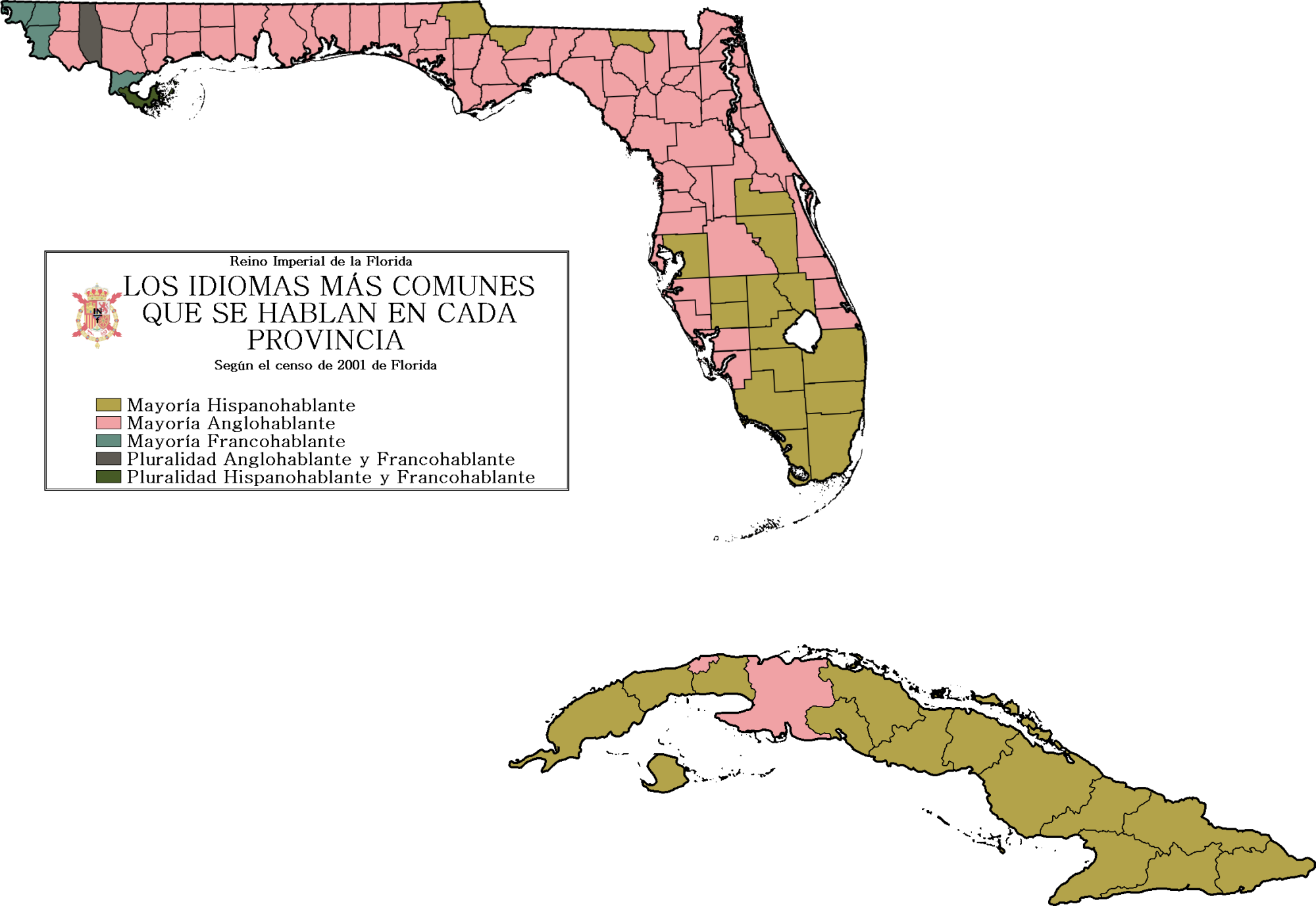
For those of you who have seen my to-do list, I'm still working on it. I just needed a little bit of a break from it and looking into something else. So, here's something from my Britwank universe, specifically some census data from the Imperial Realm of Florida. An Imperial Realm (or Reino Imperial in Spanish) is the Spanish equivalent of a Commonwealth Realm: Florida has its own parliament separate from Spain, but it still recognises the Spanish monarch as its head of state.
Despite the way this map might look, the majority of people speak Spanish in Florida, but it's close. The ratio of Spanish speakers/non-Spanish speakers is about 2 to 1.
Maybe if you guys ask nicely, I can translate the key, and possibly even put cities on the map. Enjoy!
Despite the way this map might look, the majority of people speak Spanish in Florida, but it's close. The ratio of Spanish speakers/non-Spanish speakers is about 2 to 1.
Maybe if you guys ask nicely, I can translate the key, and possibly even put cities on the map. Enjoy!
Last edited:

Also, anybody have any tips on how to depict mountains in these sort of maps?
The hard way is to do a contour map.
Kaiphranos
Donor
I PROPOSE THAT THE ATCHISON, TOPEKA AND SANTA FE RAILROAD HENCEFORTH ALWAYS BE REPRESENTED BY DARK GREEN.
Also, anybody have any tips on how to depict mountains in these sort of maps?
I SECOND THAT MOTION, AND FURTHER MOVE THAT WE ESTABLISH A UNIFIED RAILROAD COLOR SCHEME FOR ALL FUTURE RAILROAD MAPS.
As for the mountain issue, two questions: do you have an elevation map handy, and what program are you using?
(Also, does this herald a return to War of the Classes?)
Jesus wept, I don't want to do that!The hard way is to do a contour map.
YESSSI SECOND THAT MOTION, AND FURTHER MOVE THAT WE ESTABLISH A UNIFIED RAILROAD COLOR SCHEME FOR ALL FUTURE RAILROAD MAPS.
I believe this is the primary map I used for reference, which on reflection wasn't the best of maps available. Still, it showed the land grants of the Kansas Pacific, which I figured might be useful for later reference.As for the mountain issue, two questions: do you have an elevation map handy, and what program are you using?
Been using GIMP for mapmaking.
I've actually had the next bit written for a month now, but I just keep forgetting to post that. Give me a few moments to gether everything up, and I'll see if I can do that now.(Also, does this herald a return to War of the Classes?)
I SECOND THAT MOTION, AND FURTHER MOVE THAT WE ESTABLISH A UNIFIED RAILROAD COLOR SCHEME FOR ALL FUTURE RAILROAD MAPS.
As for the mountain issue, two questions: do you have an elevation map handy, and what program are you using?
And standards colors for elevation ranges! So, a different color for every 500 feet? Or do we want some sort of semi-logarithmic scheme?
Bruce
that i can actually do; it'll be real easy. god, i love photoshopAnd standards colors for elevation ranges! So, a different color for every 500 feet? Or do we want some sort of semi-logarithmic scheme?
Bruce
Kaiphranos
Donor
YESSS
I call dibs on blue for Conrail!
I believe this is the primary map I used for reference, which on reflection wasn't the best of maps available. Still, it showed the land grants of the Kansas Pacific, which I figured might be useful for later reference.
Been using GIMP for mapmaking.
Well, fortunately Colorado is basically rectangular.
This map looks like a decent match for your projection; you could use it as a basis for an elevation layer--just trace over it with paint and fill in with the bucket. (That's the method I used for this, just to give some idea what the results might look like.) Alternatively, you can go the elementary school route and just dot it with a selection of upside-down seagulls...
Alex Richards
Donor
If I might perhaps provide an authoritative view on the Colour Scheme debates and so end some of this infighting, it does quite clearly state at the top of the RCS key that it
There's a lot there that has to be worked with, so it's tailored more for detailed OTL maps.
may not be the best colour scheme for radically different ATLs
There's a lot there that has to be worked with, so it's tailored more for detailed OTL maps.
I SECOND THAT MOTION, AND FURTHER MOVE THAT WE ESTABLISH A UNIFIED RAILROAD COLOR SCHEME FOR ALL FUTURE RAILROAD MAPS.
As for the mountain issue, two questions: do you have an elevation map handy, and what program are you using?
(Also, does this herald a return to War of the Classes?)
THE MOTION CARRIES! THE URCS IS OFFICIAL, AS OF 6 FEBRUARY IN THE YEAR OF OUR LORD 2012! ALL HAIL THE URCS!
Excellent map, by the way. very textbook-like.
Quick map inspired by the recent "AHC: Independant Australia" thread in Before 1900, which prompted me to read up on Ned Kelly and discover the rumor of his planned declaration of a "Republic of the North-East of Australia" and by the timeline Remember Eureka!.
While the police on his tail had thought Ned Kelly but a garden variety bushranger, Glenrowan would prove them wrong. With the police unable to reach the settlement after their train derailed en route, Kelly read to the inn he had held hostage a declaration of an independent republic in northeastern Victoria on June 28th, 1880, a date still celebrated today as the birth of the republic. News of the declaration soon reached Kelly's supporters throughout the area, and the region, already suffering unrest, exploded into outright rebellion. The news spread quickly throughout Australia, panicking the elites in Melbourne and Sydney but arousing the interest of Irish Catholic immigrants and the liberal German settlers in South Australia.
While the police and militias attempted to root out rebel sympathies in the northeast, unrest began to swirl in other parts of Victoria and in South Australia. Soon in the heat of the souther hemisphere summer, the revolt got it's Boston Massacre; in February of 1881, violence broke out in Melbourne between republicans and loyalists, leaving nine dead. The liberal press made it a rallying cry; "Remember Eureka! Remember Glenrowan! Remember Melbourne!" and revolutionary sympathizers published pamphlets accusing the British of bigotry and discrimination against Catholics, hoping to goad formerly neutral Germans and Irish to fight. By the time 1882 had come, most of Victoria and the southeastern regions of South Australia were in open revolt. By 1886, Britain had conceded South Australia within the 132nd meridian east and 31st parellel south to the rebels and an independent Australian Republic had been declared. Triumphant, Ned Kelly stepped off the train in Melbourne to great fanfare, and by the end of the year had been elected President of a new nation.
- Status
- Not open for further replies.
Share: