Map Thread IX

Status
Not open for further replies.
Not really a flag -- more like an attempt to be artsy-fartsy based on a flag.

My apologies to the Swedes if you are offended by what I did to your national flag.

View attachment 162533

Would anyone care to read the intended meaning behind some of the things?

Argh! A flag in the map thread! Take these meds, MKN, you'll need these.
 
*Yawn*
Gonna post a France wank either tonight or tomorrow. Set about 1830-40, with a POD in the 1600s. So fat includes a shrunken Louisiana, Commonwealth of Virginia, Federal Republic of America (New England), a very much screwed HRE and a Polish-Prussian Union :)

Merry early Christmas AH.com :p
 
I think, I'll just do a Wall 'o' Text to fully explain my map.

North America

The United States doesn't practise slavery, the peculiar institution having faded away by the time it was abolished in the 1870s. So no civil war. Since France put more effort in Louisisana (just a general trend, no POD) and the Ohio Country was still British, the only avenue for American expansion was into Africa, first in Liberia and then in New Washington (Namibia). America is very stratified racially with many layers according to mixing, but the colonies are far more egalitarian with whites and blacks mixing freely.

Florida is a bit like Texas. It gained independence from Spain with American migrants leading the way. However, the American refusal to admit a new state into the union lead to a short war in which the Floridians received aid from Britain. The Floridians practised slavery up until the 1880s when the slaves rose up and tried to overturn the slavers. The slavers won, but slavery was quickly abolished and the slaves repatriated to New Washington.

The British colonies are still largely governed by the Hudsons Bay Company, at least officially. However, by now the Proprietors of the Company are elected by the people of Rupertsland and come from the vast territory. The Metis-Scots mix of people who form the nation along with the many native peoples are unwilling at the moment to alter the status quo fearing that competition with the HBC would lead to an erosion of their traditional lifestyle.
The United Kingdom of Canada is mostly French-speaking, though there is a significant Irish population in Upper Canada. With control over pretty much everything except foreign policy, the Canadans (no spelling mistakes) are happy with their lot. Much of the population are decended from Catholic dissenters and people unhappy with the constitutional monarchy after the Great French Reform.
Newfoundland, Labrador and Baffin are fully integrated into the United Kingdom, after the largely British-Irish-Danish population didn't want to be annexed to Francophone Canada. Some of the population call for a United Kingdom of Newfoundland and Baffin, but they are marginalised by those who feel that such a state could not stand up outside of the British state.
There are four crown colonies, Ohio, Charlottania, Nova Scotia and Prince Edward Island. Ohio and Charlottania are to all intents and purposes administered by Canada, and are given a very free reign hence the dominion colour. Nova Scotia and Prince Edward Island are in a state of flux unsure of which direction to take at the present time. Some want a Kingdom of the Maritimes, in all likelihood the most likely course. Some want to become a Province within Canada, an idea mostly voiced by the Acadiennes of Nova Scotia. Some even call for a direct annexation to Britain like Newfoundland, but this is unlikely considering the economic strength of the colonies.
The British colonies in the Caribbean look to be staying that way, with their economic production, cultural leanings and general importance to the British System of Trade.

Louisianne is the centre of the French Empire since the Great War in the 1920s. The colony had some success, with the help of Richelieu's Diocese System and the Mississippi Company's transplantation of French peasants. The Estates of the Ancien Regime were recreated in Louisianne, turning the colony into the most loyal colony in the whole Empire. Nobles emerged from explorers and land speculators, claiming for themselves titles like Comte d'Illinois and Chevalier de Shalage. The peasants worked on the plantations, administered by a civil service made up of Jesuit monasteries, and protected/enforced by native allies and auxiliaries. Though this system deteriorated due to distances, and became for more easy to move through, by the time of the Reform Louisanne was like a much emptier France. With the constitutional monarchy established, the Jesuit civil class was removed and a process of 'bourgeoisification' continued until only a remnant of the Ancien Regime remained in titled men and women and the divisions of the state known as diocese. Texas was annexed to Louisianne after French migrants rebelled against the Mexican authorities. Louisianne calls itself the Kingdom of the French and is currently deploying troops in France proper to conicide with the detioration in German hegemony.

Mexico is a highly centralised state, which reveres Santa Anna as the Father of the Nation. The atrocities and mistakes of his rule are only just being remembered, threatening the foundation of the entire state. However Mexico is one of the top economies in the world with a thriving chemical industry, and good relations with virtually all of its neighbours. Mexico is causing waves at the moment with its harbouring of members of the terrorist Black Fox organisation from California.

California is a reactionary, conservative state ruled by a council of Dons. Many Louisannais nobles fled to California and found themseleves integrated into the governing nobility. The Dons purchased their independence from Mexico using gold ostensibly from Spain, but really from California. Skirmishes occur regularly with their Mormon neighbours, as the Californians regard Deseret as a part of Alta California.

Central America has been pootling along quietly since its unification under Nicaragua, ruled by William Walker. Walker was the first of six Dictators of Central America, all of whom were Anglo-Americans. Until recently, the Constitution prohibited the abolition of slavery, put President Jorge de Sanchez agreed to call a new Constitutional Convention after large protests in every state, but most famously in Walker Square in the capital. The new constitution expanding the franchise and banning slavery is still being drawn up, but de Sanchez's decision has sparked the Latin Spring.

The Viceroyalty of Cippan encompasses all of Spain's remaining territory in America. Being a viceroyalty and very populous, Cippan has more than one seat on Spain's Central Junta and so forced Sapin to give Catalonia autonomy after the country was liberated from Germany's sphere. Cippan is mostly a mix of Spaniards, Catalans, former African slaves and natives.

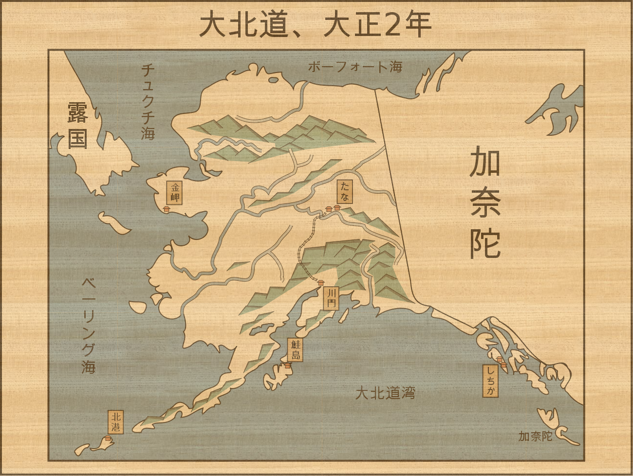
Aloksu, Japan's only presence on a continent outside of Asia is composed of Daimyos along the coast, populated by Japanese, Chinese and Manchurians and the Interior, populated by natives, Japanetis (term of the Japanese answer to Metis) and some Russians.

I'll do some more tomorrow, gotta get off now.
 
For the five hundred and sixty-eight millionth time, not every flipping border is drawn according to some sort of ultra-rationalistic abhuman appraisal of economic resource exploitation. By your reasoning half the borders redrawn in the OTL 19th century would be ASB :rolleyes: The Swedo-Scandinavian border (now that sounds weird) is mostly drawn according to the contemporary borders of the provinces of Sweden (except avoiding splitting up Stockholm) which is a rather more relevant set of reference points for people drawing up a treaty in 1836 than some arbitrary division based on robotic post-nationalist analysis of resources. That might happen in the late 19th or 20th centuries, but not in 1836.

I'm terribly sorry, Thande, but it isn't. The border you've drawn is completely random, and leaves almost no population centres (Uppsala is pretty much the biggest city, by the time) to "Sweden" (I think I speak for the entire Swedish membership of the board when I say that I wholeheartedly disapprove of the quotation marks). While Nugax is probably right, your border being as random as they are, the second half of your post gets a bit silly.
 
For the five hundred and sixty-eight millionth time, not every flipping border is drawn according to some sort of ultra-rationalistic abhuman appraisal of economic resource exploitation. By your reasoning half the borders redrawn in the OTL 19th century would be ASB :rolleyes: The Swedo-Scandinavian border (now that sounds weird) is mostly drawn according to the contemporary borders of the provinces of Sweden (except avoiding splitting up Stockholm) which is a rather more relevant set of reference points for people drawing up a treaty in 1836 than some arbitrary division based on robotic post-nationalist analysis of resources. That might happen in the late 19th or 20th centuries, but not in 1836.

There is a difference between peripheral territories, overlapping claims, and heartlands. Yes, they drew lots of silly borders in the 19th century but a) YOU are the one doing a robotic improbably even segment cutting of the map and ignoring the highly emotive identities, traditions, and senses of place that existed even back then; you wouldn't divide Bohemia by the Elbe, take Yaroslavl from Russia, or excise Essex from the south of England, and b) most of the stupid border cutting of the 19th century was done by people far away from the borders in question or in Germany (where stupid borders had been in fashion for centuries, and the continuous nature of the Northern European Plain makes it less relevant) - the Danes and the Swedes are intimately involved in the situation here and would be aware of its impracticality.

If you think you're following the Landskap or the later counties, I'm afraid you're pretty wrong. I maintain that cutting it at Norrland-Svealand retains your aim without being something no one would ever think off.

Finally, I raised the issue once in your thread, set out my arguments, and dropped it when you made it clear you were staying the course - try not to get so worked up ;)
 
Last edited:
A little xmas present: I decided to do a "cover" of
fireclaw722's map in the last thread. First, a general map:

Bruce

ToFixRedo.png
 
I was thinking... Would it be possible for older traditions and feuds, such as the HRE/German Confeds. and how Prussia and Austria fought for control over them, to survive into the modern era?
 
"The collision of the modern and the traditional in the Japanese Empire at the turn of the century is perfectly illustrated in this 1913 woodblock map of Daihodou (Today the Kawakado, Shichika, and Tana Prefectures). The style clearly shows the influence of traditional woodblock prints, but with a marked simplification and depicting a thoroughly modern Japanese scene; Daihodou had only been in Japanese hands for some 35 years at this point, and the Kawakado-Tana railway, finished only a year before, is visible. This particular piece, annotated in English, was donated by the estate of Lord E.A. Blair, 1st Baron Blair, the noted Orientalist, commander of the Royal Burmese Police, and Ambassador to Japan."

-Description of a piece displayed in 2002 at the Anglo-Japanese Exhibition at the British Museum, commemorating one hundred years of the Anglo-Japanese Alliance.

daihodou_by_snackserv-d4k1i0i.png


Unannotated version;

daihodou__unannotated_by_snackserv-d4k1i1t.png
 
people__s_union_of_india_by_neoteros-d4k1x4y.png


Still a Work in Progress, but i posted it to DA since i was afraid to lose the work. The bits that i did (more to do) and the colours used kind of give away the idea of this map... let's just say i was inspired by a fairly recent thread, and that this India's flag will most likely include a fair share of red.

The base map is the blank version of Victoria II's. It's really useful for modern ethnic or administrative borders. In this case, i have tried to go with language-based borders, with some alterations.
 
"The collision of the modern and the traditional in the Japanese Empire at the turn of the century is perfectly illustrated in this 1913 woodblock map of Daihodou (Today the Kawakado, Shichika, and Tana Prefectures). The style clearly shows the influence of traditional woodblock prints, but with a marked simplification and depicting a thoroughly modern Japanese scene; Daihodou had only been in Japanese hands for some 35 years at this point, and the Kawakado-Tana railway, finished only a year before, is visible. This particular piece, annotated in English, was donated by the estate of Lord E.A. Blair, 1st Baron Blair, the noted Orientalist, commander of the Royal Burmese Police, and Ambassador to Japan."

-Description of a piece displayed in 2002 at the Anglo-Japanese Exhibition at the British Museum, commemorating one hundred years of the Anglo-Japanese Alliance.

Wow, that is beautiful beyond words. :eek: What program do you use?


Still a Work in Progress, but i posted it to DA since i was afraid to lose the work. The bits that i did (more to do) and the colours used kind of give away the idea of this map... let's just say i was inspired by a fairly recent thread, and that this India's flag will most likely include a fair share of red.

India with Sindh and Bangladesh and Nepal but not Kashmir? Care to explain a bit more?

---

And my own work, the United Baltic States, which includes Kaliningrad, due to Kaliningrad becoming a Jewish state after the German surrender in World War II. Later, after the dissolution of the U.S.S.R. the four countries become one united country.

baltic.png
 
Wow, that is beautiful beyond words. :eek: What program do you use?


India with Sindh and Bangladesh and Nepal but not Kashmir? Care to explain a bit more?

---

And my own work, the United Baltic States, which includes Kaliningrad, due to Kaliningrad becoming a Jewish state after the German surrender in World War II. Later, after the dissolution of the U.S.S.R. the four countries become one united country.

I approve of countries that have Lynx's on their flag.
 
India with Sindh and Bangladesh and Nepal but not Kashmir? Care to explain a bit more?

As i stated, it is unfinished. The real thing will go from Afghanistan to Burma. The cause, is a Russia even shittier than OTL, that leaves the British full hands on the area. This will have interesting side effects, the bigger of them is a subcontinent that adheres to a form of Socialism bastardized with Gandhian thought - the Congress will never come to life in this timeline.
 
Top
Status
Not open for further replies.
Top