Lifelines Of Logistics - How To (Not) Draw Your Transit Maps/Diagrams

Retrofitting (Part III) - The Tail Is Wagging With The Dog


Building transit in the city center is a diresome and expensive affair. Period. The outskirts are less problematic, especially when they're hardly developed. The more responsible (read: democratically accountable) a governance is required to operate, the more political capital has to be achieved to execute the aforementioned diresome and expensive affair. So there are actually some modern cases where a nascent rapid transit system was actually born outside its later core.


Bay Area Rapid Transit - Oakland To Fremont

The maiden service in 1972 ran on a tangential line exclusively in East Bay before true crossrail services via Transbay Tunnel into San Francisco could commence in 1974. The sensible completion of the core came in a short order of time, but you don't have to count on it. The American example is noteworthy because it's also an example how local referenda played a role to raise the necessary political capital beyond term limits and changes in mayoral and gubernatorial chairs. It's also an example how a potential role model never came to be one. It's such an autarkic system that it even puts the S-Bahn systems in Berlin and Hamburg to shame. Yet for this very reason, it never caught on anywhere else which means that the lack of scale economics makes the maintenance of this system comparably expensive. You may be tempted to think that the Silicon Valley extension through San Jose is no guarantee that the gap between Milbrae and San Jose will actually be closed one day to create a ring for BART.

Nuremberg U-Bahn - End Station Is First Station

The satellite town of Langwasser in the southeast of Nuremberg has a rather short history. It used to be woodlands until the late 1910s after wildfires resulted in their clearing, allowing for agricultural uses before becoming the main tent camp for the ordinary visitor of the Reichsparteitage, later serving as a prisoner camp and stuff before the Americans moved in. Langwasser was built for both residential and industrial uses in mind and its typical post-war nature can also be seen in the fact that the main roads in Langwasser have been named after formerly German cities in Silesia. Its panel housing also provided for meaningful passenger numbers to sustain a rapid transit system.

The line U1 one of the local subway system has very consequently been built outside in and, by the time digging started, no other line had a clear direction inside the city center and even the stretch of U1 that opened with the system's inauguration in 1972 was confined to Langwasser (Langwasser Süd - Bauernfeindstraße) and extensions in 1974 (to Frankenstraße) and 1975 (to Aufseßplatz) only made for a slow approach to the city center and it took until 1978 (to Weißer Turm, including Hauptbahnhof) and 1980 (Bauernschanze, including Plärrer) until the line meaningfully pierced Nuremberg's city center. The extension to Fürth railway station until 1985 was therefore way quicker. The line U2 was built inside out, but also from edge of the center at Plärrer (interchange to U1, 1984 to Schweinau, 1986 to Röthenbach) first before piercing the center in 1988 (Hauptbahnhof) and 1990 (Rathenauplatz). The 1990s so northward extension of both U1 and U2 which have also seen supporter services called U11 and U21. In the 21st century, an iteration of U21 became the U3 sharing the trunk line of U2 but having different bifurcations. The desired network was actually supposed to feature a third trunk line one day, but development hell is development hell.

Rome Metro - Line C

I had two weeks of sick leave before Easter Holidays after my 10th birthday in March 1996 due to the measles and I recovered well enough after a week that my mom organised a Rome vacation on the fly. Ever since I've been there, I remember two lines crossing at Termini and Mom keeping Grandma from giving change to a panhandler. Line C looks a bit like foreign body in the system and that's no accident. Just as with the Langwasser subway in Nuremberg, the remotest southeast was worked at first. Unlike Nuremberg, there's also been a narrow-gauge legacy railway on the way that was converted to become part line C from the start as it did in 2014 from Montecompatri/Pantano to Parco die Centocelle. Thanks to the legacy tracks, the "slow approach" went faster than in Nuremberg, reaching Lodi in 2015 and finally reaching an interchange to line A at San Giovanni in 2018. The mayor of Rome from the Five Star Movement actually wanted to scrap the further extension via Amba Aradam to Colosseo (interchange to line B) in order to save money (understable given the archeological mess) but rule of law prevailed because pacta sund servanda or "who screams is wrong" as people say in my home region. This is yet another example for how much political capital you need to pierce the city center. Sometimes you need a convertible existing railway as a start.


Convertible Lines - The Gradual Midwife For New Rapid Transit Lines

Underground tunnels for LRT lines needn't, but can become the cornerstone for future independent transit lines. The Brussels Metro is a textbook example how streetcar lines were consolidated in an ever extending tunnel until the moment when it was sensibly long enough to be rebuilt to metro standards. The carcass was big enough from the start, heighten the platform, install third rail, here we go. This is piecemeal strategy for harnessing small amounts of political capital at a time until the job is done. Most systems that were started this way however just stayed this way as can be seen in e.g. a lot of cities in Germany.

More often, it's actually a line broken in two which is successfully practiced. What's now line 5 of Saint Peterburg Metro actually arose from a northwestern extension of line 4 with the split only happening after the northwest was actually down and an alternative southward extension was implemented. Line 4 is supposed to get a western extension from the point of divergence (hehe) one day, but it's not a high priority.

Warsaw Metro is in the process of extending line M2 into both western and eastern directions. The eastern direction will be important because it's a bifurcation which will, you guessed it, provide the means for the sensible split into yet another line M3 from northeastern Brodno to Constitutional Square where there's now a gap in line M1 between Centrum and Politechnika stations.

The London Underground knows this to well to, the Stanmore branch of the Bakerloo Line evolved into the independent Jubilee Line by getting a central underground extension by some stops, long before it became the lifelines to the Docklands. Just adding new interchange stations to an existing line improves the capacity of a system a lot. And if we think about it, isn't this what crossrails are all about?

Vienna is currently working on splitting of a new line U5 from the existing line U2 that's getting an alternate southwestern extension. They promise that the final iteration of the U-Bahn network after the split's completion raises the number of transfer stations from 10 to 14, making it fit for a city with more than two million people in the future. Vienna already had a history in the 1980s of turning an entire light rail system into two seperate U-Bahn lines. The third branch that later became a suburban railway line never became part of the city's municipal transit system.

And let's not forget Berlin, especially West Berlin. The Neukölln branch of line C became a handy appendix both to split it off into an independent line H (U7) which I've already discussed and also to create the satellite town of Gropiusstadt with a subway extension from the start. An extension that could one day easily extend to the mess that's the Berlin Brandenburg International Airport.


Meanwhile in Moscow

Post-Soviet Russia under Vladimir Putin needs to produce a lot of output legimization to keep up its "managed democracy" and the daily commute to work is a bread-and-butter issue that just cannot be ignored. Now how is this about the tail wagging with the dog. Well, look at metro line 8 and 8A. The outer appendices in western and eastern Moscow are working, but the middle section is still missing. The eastern appendix was initally built to connect with the ring line 5 to be accessible to the whole network and is just slowly piercing central Moscow. The western appendix 8A on the other hand relates to the Third Interchange Contour like the Q service to the Second Avenue Subway in New York City, it runs on it to excuse the costs of the bigger project until its big enough to warrant an own service (line 11 in Moscow already running, the T train running in New York City when Lower Manhattan is reached). The only difference is that the Q service is here to stay, knowing the bifurcation mess in NYC, whereas line 8A will eventually leave line 11 alone once the appendices meet, knowing the clarity in Moscow.

And as in other cities that are famous for being pioneer metro systems, which Moscow definitely is, it wisely stopped seeing itself being too good for alternative solutions that contradict its old orthodoxy. The satellite town of Bukowo needed a metro, but an extension of line 9 would've been too expensive and a separate "light metro" opened up the opportunity for connecting Bukowo not just with line 9 alone, but with line 6 too, starting out as a line L1 and eventually becoming line 12. The monorail in northern Moscow became line 13. An orbital railway mostly used for industrial purposes until the fall of the USSR became the Moscow Central Circle, a full-on orbital overground line that became line 14. Yet another "light metro" stub line in the city's southeast became line 15 and and a southwestern sister not fear from line 12 will do the same to connect a fringe place with lines 1, 6, 11 and 14. This looks impressive on paper and the ordinary passenger just cares about it running. Yet this could also be considered a bit of cheating, don't you think? All those lines actually have proper names, like anywhere in Russia actually, but using the numeration of the metro system to designate connections that really don't feel like metro when you're inside them could also be seen as an attempt to lead the sceptical horse of a Moscowite to the water. You don't do that in the Anglosphere.

And asking the Prague fanboy as I am, well, the line D is also all about just connecting some southern suburbs to Pankrac station for the time being. I can be glad if said line D will one day (i.e. around 2050) form an even more perfect Saint Peterburg-style triangle for four lines that will be equally supplemented by the double-crossrail system "Metro S" where Florenc and Opera stations provide easy interchanges from all Esko lines to all metro lines. As I've already discussed. And Hamburg is now underway to give a northeastern borough a line U5 that's already been promised in the 1960s and will likely remain a stub for ages.
 
coronavirus, covid-19, sars-cov-2, lockdown
Exponential Growth - Let's Talk About Pandemics As We're At It

Undertakers in New York City are quoted with words like how the Coronavirus produces way more deaths than 9/11 and is more comparable to the AIDS epidemic in the 1980s. Just like HIV/AIDS showed the arrogant First World that even rich societies are not immunes to infectious epidemics and stopped homosexuality from being the "most open secret of society" to something every child and their dog knows about, SARS-CoV-2 laid bare that so-called role model Western health care systems are just so-called. It often laid bare what's already been broken in many countries. Something like masks aren't rocket science, but we lacked even if we could've had them. My native Germany or neighboring Austria may not appear as broken as other neighboring countries, but all states of Germany have required masks at public transport since Monday, all but Berlin in supermarkets and other shops (and Berlin is following suit), Hamburg being a bit stricter than the rest and NRW requiring the mask at six specific types of venues that I can't really recall because I don't live in that state. The news at the ORF in Austria today said that lockdowns in Austria will be lifted gradually over most venues in the course of May, stuff like outdoor yoga courses with social distancing may then assemble as much as 10 people and funeral may have as much as 30 people.
Had my mother survived her flu-induced cardiac arrest in 2015, she'd be a typical risk person for this new Corona virus and could have died a similar death as she already did.

Handling the COVID-19 crisis is a bit like battefield triage from the start, it's trying to achieve the optimal balance between optimal health and survival on the one hand and optimal livelihoods on the other hand. If the number of deaths reaches the tenfold of the so-called "expectable death numbers" which is actually to expect in a scenario of a consequent herd immunity approach, then it's a scenario that's not politically survivable. If the economy tanks because a "new normalcy" after lifting the lockdowns won't be achieved for whatever reasons and 2021 still looks worse than 2019, then it's a scenario that's not politically survivable. If people don't get their lifesaving treatment because of a "Corona First" policy that postpones the treatment after that patient will have died, then it's a scenario that's not politicially survivable. And don't get us started on the additional domestic abuse and kids requiring professional tutoring etc.
Anybody who says that "let them just die as they wouldn't have survived that year anyway" should think that one avoidable death that could've been postponed for years to become what we dub "living a full life" is the ex-husband of former governing Mayor of Berlin, Klaus "I'm gay and it's a good thing" Wowereit that had COBD as a pre-existing condition. Berlin is also the home to the so-called Berlin patient, an American gay man living in Berlin who was healed from his year-long HIV infection after a leukamia required a bone marrow transplant in the 2000s and one of the 100 compatible donors was found to have a genetic resistance to HIV and became the donor for this patient. By 2020, there's also a London patient that neatly follows the Berlin patient precedence.


Foresight and Hindsight

At the beginning, Chinese authorities tried to keep the knowledge about SARS-CoV-2 and COVID-19 under the rugs to avoid panic in the Chinese public. This could be called the Chernobyl moment of the PRC. Just as the radioactive cloud from the Soviet Union was bound to trigger the measurement systems at a Swedish nuclear plant, at a critical moment before the Soviets could even think about effectively keeping things under the rug, the virus couldn't be censored and wouldn't respond to armed force. The shutdown was the logical conclusion. Of course, it's first and foremost about realism and responsibility. Gangs know that you don't shit where you eat and that's why the gangs of Rio enforce strict curfews and mask duties in the favelas. If the populist in Brasilia won't bother, they'll have to. Countries may abuse the crisis to tear down political rights and increase surveillance, but if stuff like in Bergamo happened all over China, the authority of the government would be at stake as it can't protect its people against an existential threat. No, Xi Jinping is way more of a modern Brezhnev and in no way a Gorbachev. But especially because of this, doing nothing could've ignited a Chinese spring at unprecedented levels if the virus would've gone through the barracks and police departments. And who watches the watchers in this case?

If we compare Philadelphia and St. Louis during the pandemic known as the Spanish Flu 1918/19, you'll see that St. Louis ordered strict quarantines and therefore had only half as many deaths per capita as Philadelphia. On the other hand, St. Louis used to be like two weeks behind Philadelphia and was therefore warned. Today, Milan is seen as the entry point of SARS-CoV-2 from Chinese tourism to homegrown European hosts. Bergamo is a suburb of Milan, so don't be too surprised about how it feels the ramifications of four weeks lost on doing anything. The Austrian, more exactly Tyrolean, ski resort town of Ischgl quickly developed into a hub in its own right, Germany had its own small Bergamo called Heinsberg etc. By this writing, Austria has supposedly achieving a reproductive rate of 0.6 and the strict shutdown after hesitating too much at Ischgl is largely to thank for this. Germany has seen some rebound, however, from 0.7 to 1 or so they said. Yet these shutdowns wouldn't have happened if there hadn't been a Bergamo.


Herd Immunity and How To Get Out Of A Lockdown

The UK and Sweden worshipping herd immunity before eventually abandoning it had nebulous reasons. For the UK, reasons are comparable to the US and Brazil: A populist head of government had to divert attention from the fact that the health care system were in no way ready to provide for the care that will be needed. Like I said with the favelas, shit hits the fan when the gangsters are the sensible ones. Sweden's social-democratic approach is most concerned with the welfare of its children (that's why day cares and schools were supposed to stay open) and a fear of strangling its economy and, if we're really malicious with the Swedes, an opportunity to drive the native Swedes to native destinations for skiing if Ischgl is already in quarantine. Singapore is a warning to both approaches: It shows how getting out of a lockdown is hard because it went with a second wave of Corona cases.

German Stern magazine (yes, that one with the Hitler diaries) in its issue from April 23rd wrote a lot about how a lot of businesses have to cope with anything between lockdowns and shutdowns. I didn't know that e.g. two and a half million people in Germany work in the hospitality business including gastronomy and is too much of a serious issue to dismiss as a leisure and side issue because there are a lot of livelihoods for whom it isn't. This is something that stimulus packages can address, livelihoods are somehow secured (dole for affected workers, eviction moratorium if COVID-19 makes you fail to pay your rent, a gastronomer's lease will be paid for by the state if it's a health-related shutdown etc.). Industrial enterprises however are confronted with the fact that evey cogwheel is not to take for granted. The magazine wrote about how one specific small- or medium-sized enterprise already did an emergency plan when politicians still struggled to impose a lockdown, especially if parts come from all around the world and every lockdown hits another part of your supply chain. They did effective damage control, output only decreased by a quarter. Then again, said enterprise also commented that they will regionalize their supply chains due to the experiences of the lockdowns. The facilities in North America, Europe and Asia are supposed to become as autarkic as possible. They will, of course, help each other out when it's prudent and possible, but short distances are to be prefered in the future. On a personal note, we've got a family business whose supplies largely come from Italy and my uncle said that well, they should've locked down in Italy at the start of March for health's sake, even if it meant we could've filed bankruptcy, so we're lucky we've got our last vital supply before the lockdown. Volkswagen did a radical shutdown from the start especially as the shutdown in China affected the supply lines long before COVID-19 became apparent in Europe. Here they wrote which things inside the thing inside the thing they'll produce again first and in that particular case, that semi-finished good was destined for the works in China because that's where lockdown are already getting lifted again.


Other Pandemics In Comparison

I chatted with some pal over the phone about stuff after I messaged him, like many others, to ask him how Corona is affecting his daily life right now. He's a realtor and is now doing his apartment viewing via Skype because people are afraid of contracting the virus. His professional life changed big time, but his personal life didn't because he already ordered himself some kind of voluntary social quarantine three years ago to focus on what's important. He said that, economically, COVID-19 would be comparable to the Spanish Flu 1918/19 with a quick recovery in the first wave and that the virus itself would be history half a year from now. He expects a second wave, however, that would unravel the financial industry worse than the Global Financial Crisis and if this wave will happen will depend on whether or not SARS-CoV-2 mutates into a new form that would prove just as much a challenge as its original.

The Spanish Flu is supposed to be special because it targeted especially young adults and World War I helped it spread from America to the European front lines. Yet there's a much easier explanation than hyperactivity of younger people's immunities: Older people retained some herd immunity due to the Russian flu of the late 19th century which the posterity hadn't. The Hong Kong Flu was just a decade after the Asian flu that was the biggest pandemic between Spanish Flu and Corona. Corona is dangerous because we're still virgins to it.

On a related note, the medical laboratories University of Mainz (Mayence, capital of Rhineland-Palatinate and home to the ZDF and initally Sat.1 television stations) announced that computer simulations found some Hepatitis C drugs to be realistically effective against SARS-CoV-2 and while clinical trial are inevitable, digitization is very great at finding the needle in the haystack and they said that those simulations needed two months. Just another good news besides the extraordinary approval of remdesivir against COVID-19. In Hamburg, researchers found that a lot of COVID-19-related death are due to blood clots. This is not to say that aspirin and ibuprofen would heal COVID-19. It just means that they can prevent some typical COVID-19-typical deaths giving the body times to cure itself.


Is Nearshoring The Better Offshoring?

If you've learned business administration or anything comparable, you may remember that a lot of variables get into deciding what kind of half-goods to purchase and which plant is supposed to produce which model or part inside the same corporation. Components shouldn't break and yet not cost too much also, some stuff may be time-critical etc. If you remember an earlier chapter about aircraft logistics, you remember how I used to play the Patrician economic simulation games and took my community's charts (which I created) to explain hubs for aircrafts. There's another feature in the game: Different cities produce a variety of goods in differing efficiency, a "normal" or "low" production means that the same plant with the same labor costs only delivers 75 percent of the output of its effective counterpart, though the input of raw material if needed is also decreased to 75 percent. Efficient productions are considered the norm, so a "normal" or "low" production is casually called an inefficient production. Taking the inverse value of three quarters, the unit cost from an inefficient production is a third above the effecient production. The question is if you're really supposed to produce merchandise that's a third more costly than from elsewhere. You see that this is a relative thing. Basic goods will require a political price that results in a loss to keep them happy in the city anyway which will eventually be compensated by high-profit margins in cash cows. Timber is very cheap, is needed to fire a lot of plants, needs a lot of room inside a ship and the inefficient production is quite widespread, hence you set up sawmills everywhere you can. Grain is one of those goods that you can hardly sell for a profit without putting off your workers and their families, so an inefficient grainery is still preferable to a want of grain and grain is still a cheap merchandise. Then there's stuff like meat that's expensive and yet not completely indifferent in respect to the people's mood, that's where people say that a small production for the local people is desirable because they're then fed and don't need to ship everything in and yet it's no reason to set up a whole meatpacking district in that town. The relative price level is king here in relation to the profit-margin. Then there's stuff like pig iron that's needed for iron works and wool that's needed for clothes, both are classical high-cost raw materials. Here it's generally adviced not to employ an inefficient production even if it can locally worked into the end product. That's also a hit and miss, hyper-expensive wool for weaving clothes indeed will hardly have a profit-margin, but wool is important enough to warrant a local production that's directly sold to town even if it's hardly over its unit costs. Iron goods however have a great profit-margin and while an efficient production at full returns of scale means 250 gold coins for a barrel to be sold at 450, selling a unit of 312 gold coins per barrel sold at 450 ain't bad either. Edinburgh on standard map has big a third wall, ineffecient timber, pig iron and wool can be processed to iron goods and clothes, fish being the third and final efficient production in that town. If you do a no-inefficient policy just because, you may be stuck with filling workers into "efficient" plants in other towns that experience overstretch whereas Edinburgh is full of beggers. Orthodoxy can kiss your ass.

Short journeys are a value too, especially if tensions are high and Corona is king. Regional integration is there for a reason. The United States couped a lot in Latin America, but Mexico was way too close that additional refugees just weren't worth it. This natural interest in Mexico's political stability was also the base for NAFTA, maquilladoras may be there to cheaply produce stuff, but they're also geographically close and make the supply chains to America resilient. The European Union and its associated vassal states (sorry for calling you a vassal, but EU rules do rule you to a great degree) make for common standards in the whole club and offer some legal cohesion in addition to geographic proximity. You cannot properly unweave globalization and produce everything inside a car in one continent, but I always had great sympathy for Volkswagen wanting to produce on every continent. Even if Wolfsburg got nuked, there's some industrial capacity in the Global South to get back running.


Meanwhile in Berlin

Did you know that Berlin Brandenburg Airport has been finally approved for operation? That all the flights that have been reduced anywhere because of Corona have been concentrated at the old Schönefeld Airport that will become part of BER anyway? That Tegel has been "temporarily" closed in order to reduce operation costs during this crisis? And that the opening last scheduled for October 2020 could now actually be preponed? And "temporarily" will now actually mean forever? Who would've thought?

EDIT: Well, this was planned before various lockdowns and border closures were lifted inside Europe at least from June 15th onward. Demand has risen again and considering how social distancing will need its space, keeping Tegel open for the moment ain't that unsensible. At the end of 2020, there are three new openings that warrent a visit over Christmas and New Year's Eve. First, BER will have opened and consolidated all Berlin aircraft traffic. Second, the gap of underground line U5 will have closed. Third, the Humboldt Forum in the rebuilt Berlin City Castle at the so-called Museum Island will be opened. Yet sadly, the new U5 station of Museum Island will only open in 2021. The subway is done, but the station isn't, but that's okay, it's about the great picture. The next entry is about relief in transit systems. We'll get to Paris, London and Berlin.
 
Last edited:
Retrofitting (Part IV) - Why We Need This Additional Trunk Line. Or Extension. Or Whatever.

Getting back to the U5 thing in Berlin where Museum Island has yet to be built, there was the question why it should be even built. There was a treaty between the German federal government and the state of Berlin wherein the Fed gives Berlin money and Berlin therefore had to build stuff. Among them was the so-called Chancellor Subway which means the completion of the U5 in Central Berlin. What became U55 was part of several tunnels under the Tiergarten and opened prematurely to avoid paying back money. It is also the major reason why closing the gap between U55 and the old U5 was done after all, do not want to have to pay back that money. You could have built more apartments and whatnot, but treaties must be followed. Period. And that is a good thing, just as former governing mayor Klaus Wowereit used to say about his homosexuality.

Berlin had to be forced to extend the U5. Especially Wowereit was not all that keen on it, especially after the banking scandal in Berlin ousted his predecessor and public coffers were empty anyway. So that's why at least U55 was opened to calm the nerves of the courts. There is also a sound argument for not extending U5: There's already the Stadtbahn where several S-Bahn lines run an intense headway between Alexanderplatz and Berlin Central Station anyway, so why bother with another rapid transit line? Just for the tourists? Well, not really. Both straight trunk lines of the S-Bahn Berlin, the Stadtbahn in east-west direction just as much as the old Nord-Süd-S-Bahn-Tunnel having its direction in its name, run at capacity. It's also why the rapid transit line to Hellersdorf built in the 1980s in East Berlin was realized as an U-Bahn, it already ran from Alexanderplatz to Tierpark in the rough right direction and therefore worked out as a second trunk line by which we mean the same line U5. If your destination in Berlin is somewhere along the U6 or U8, it is easiest to just dive into the underground railway system from the start and have a sheltered interchange, what with being all-underground from the start. OK, that part is more a matter of taste, but if the Deutsche Bahn needs to fix the Stadtbahn or its drivers go on strike, you're happy if the rough direction is also served by a parallel-running U-Bahn by the BVG and vice versa. This could go all the way to the U9 at Turmstraße where people from Zoo Station could easily circumvent a broken Stadtbahn and this also was a factor in the cost-benefit analysis for the Chancellor Subway. Further extensions of the U5 would lead it to Jungfernheide at the northwestern Ringbahn before reaching what ceases to be Tegel Airport whose main structures enjoy monumental protection and will become the home of a complex called Urban Tech Republic where business and science are supposed to find yet another home in Berlin.

Jungfernheide would offer a cross-platform interchange between that U5 and an existing U7, and a stop for regional railways between Spandau and Berlin Central Station, the S-Bahn at the Ringbahn in its northwest where it will feed into S21 to Berlin Central Station too and, of course, a rejuvenated Siemensbahn that's been lying dormant for 40 years and will have to be reopened when Siemensstadt 2.0 shall be accessed. There are some people who find it a shame that this Siemensbahn shall be little more than an appendix to the Ringbahn and are of the opinion that, if you add the Siemensbahn and S21 and the additional passengers from BER airport together, the old Germania plans for an underground railway tunnel (U-Bahn before Hitler, S-Bahn ever since) through the borough of Kreuzberg would fill a missing link to create a third radial trunk line through Berlin. They called this project "S6" as it is the only number is the S-Bahn scheme that's mostly vacant, though services called S6 have been run and will be run again in the immediate future also. The proponents themselves say that closing said gap in Kreuzberg would be a project of 30 to 50 years, crossing U6 at Kochstraße being the most awful part, crossing U8 at Moritzplatz eased by a carcass built under it in the 1920s, Görlitzer Bahnhof of U1/U3 being elevated anyway and Glogauer Straße becoming an extension of the M10 tramway from Warschauer Straße to Hermannplatz before finally crossing the Ringbahn at a new station Kiefholzstraße before merging with the Görlitzer Bahn (also leading to the BER) which will be a challenge as the motorway A100 is also extended here at the moment and won't make it easier.

Yes, there are projects that are way more overdue. That project would turn S21 into the third crossrail of Berlin with a clearly distinct direction. Not bad if you remember that S21 is supposed to be the second north-south trunk line and act as a supplement to the first one, not as a replacement. And nobody said that S21 should stop at Potsdamer Platz to bend over, it is supposed to be finished with all three stages. And yes, some lines are supposed to be re-routed from the 1930s legacy line to S21 and considering that the mess will branch out into two lines south of Potsdamer Bahnhof and Anhalter Bahnhof (S21 bypasses the latter straight) that both existed before there was a crossrail, you could argue that assigning each southern branch to a firm northern partner should be enough to allow for tight schedules that forbid meshing. And that is what those generous platforms at Potsdamer and Anhalter were built for. Well, yes and no. Potsdamer yes, but they work out as reserves for an S6 as well. And Anhalter was only built that generous for something like S6 in mind. It also didn't hurt that any legacy north-south station that used to have a corresponding overground terminal was built with turnbacks which proved to be right after the SS bombed the ceiling between said link and the Landwehrkanal at the end of the war which flooded the central section of the tunnel. The point is that it is already business as usual to group the S-Bahn services into separate trunk lines when calling franchises for bids. They were still mostly won by Deutsche Bahn, but still. The Ringbahn is done together with the Görlitzer Bahn and therefore constitutes the biggest steak of them all, that S6 could enable a split in the franchises though, of course, the Ringbahn is hardly at capacity and some direct connections may well survive such a split. Usually it is three lines per trunk line running a 10-minute headway resulting in something like a 3-minute headway. The ability to streamline the trunk lines in their centres is necessary if the situation gets so bad that you would need a 2-minute headway and the best case to show is the Northern Line in London.


Why Camden Town and not Euston?

Most Londoners and many Brits and especially many transit nerds (which in my opinion just like to travel in their minds like me) know about the ongoing struggle at Camden Town and the desire to finally split the Northern Line, preferably in a way that the two successors cross each other visible on the map instead of just touching or kissing each other, e.g. Charing Cross goes to High Barnet and Bank goes to Edgware. The platforms of the Edgware and High Barnet branches at Camden Town form an acute angle whose joint also makes the entrance and whereas you can walk between the platforms in each direction, those passages are way too undersized to cope with the number of interchanging passengers to be expected when the line finally splits. Even without interchange, Camden Market as a retail site is so overcrowded that the tube station is exit-only at peak times on Sundays. That's why Camden Town tube station will see its extension after all, an infant school to be demolished to create a second access to a new big passage way that connects to both platforms at its remote ends when seen from the acute angle joint. Is it sufficient to allow for the split? It is necessary to make it possible in the first place. A split is supposed to fasten the schedule from a 3-minute headway to a 2-minute one. Or was it 2:30 (24 tph) to 1:40 (36 tph)? But unless sufficient walkways exist, it is still better to put up with this suboptimal bifurcation situation than jamming the station and sabotaging capacity even more.

I read a discussion how Euston would be better for this as it provides for an at least theoretical interchange opportunity even if it is not cross-platform. But this is it, it's just as abysmal as in Camden Town pre-extension and considering how Euston station is supposed to become overcrowded anyway because of High Speed 2 after it's been rebuilt enough to relieve Old Oak Common from its provisional terminal function, Euston station is so overburdened that we could be happy that these split works can be outsourced to Camden Town as most passengers live up north anyway. It is about peak capacity and if you really must go from Charing Cross to Bank or vice versa, those two additional stations to Camden Town will not kill you. Savvy?

Crossrail 1, also called Elizabeth Line, was always about capacity and relief. All stations from Paddington to Stratford either access the Central Line or the Hammersmith & City Line and Liverpool Street with its own terminal station is lucky to access both, but Crossrail means that you can circumvent those overburdened lines and hopefully get directly to your last mile. It also shows that it’s alright if some relation features seemingly redundant connections that aren’t that redundant in the big picture: Bond Street to Tottenham Court Road and back can be done by bus or by tube now and by Crossrail in the near future. Both stations feature interchanges to different tube lines, however, so any connector that is supposed to “drop off the load” where it is most handy is always welcome. And as a parallel to the U5 in Berlin, the Victoria Line was especially built to relieve the Piccadilly Line by taking prospective passengers directly from several rail stations from the start and get them to their desired last miles through new interchange stations far away from the Piccadilly Line. The major reason why the Jubilee Line was extended up to Stratford was to relieve the Central Line and the fact that the Docklands were already next door anyway. If you think about it, only the residents of the south-eastern branch including the Docklands will get the feeling that they essentially get a new tube line to Inner London. For commuters, it feels like two or three terminals merged into one where you can disembark at your desired “personal terminal” to fetch the right tube line. Otherwise, it just connects “the world to London and London to the world” with Heathrow Airport having a direct connection, HS2 accessed via Old Oak Common and Farringdon accessing Gatwick and Luton airports via Thameslink which could be seen as some kind of Crossrail Zero.

Speaking of HS2: High-speed rail is maybe the best example where the money is totally worth it: It’s insane to lay a second set of tracks to a legacy line when it’s grown into settlements and the radients and parameters don’t work out for high speed anyway. So, you best leave those towns and services alone, built that new trunk line, relocate traffic to the new line where it is sensible and use the freed capacities on the legacy lines for new pursuits. Moving even more traffic from the streets to the tracks, whether for passengers or for goods.


Tramway or Metro? Both.

Welcome to Paris or rather the Île-de-France. Paris axed its tramway in 1938 because the new Metropolitain effectively took over its purpose. The 21st century saw a rebirth of this abandoned mode of transport in the outskirts of Paris. The lines 3a and 3b run parallel to the Boulevard Périphérique which was built upon the former city wall and constitutes the municipal borders of the capital of France, but the rest runs outside. They have built classical tramways, the one or occasional Translohr on the way, but also light rail lines called Tangentielles and whereas it is all great and necessary, they will not substitute the Grand Paris Express. Paris had the opposite problem of London and Berlin lacks both problems: Whereas London had enough tangential railways left to form a circle of Overground lines and lacks diametral railways where Crossrail has to solve the problem, Paris hardly has problems with diametral railways (big-ass RER lines up to letter E, an automatic metro line 14 to relieve both RER A and line 1) whereas the orbital sphere is severely underserved and a set of new metro lines is supposed to build and close a ring.


Indicators of accessibility

For Grand Paris Express, they’ve taken two places along the future circular line in its southwest and southeast to show how much of Paris and environs you can reach in 45 minutes now without it and in the future with it. Taking a site as an example is always arbitrary, of course, but as Paris proper is already overserved with metro lines and the focus is supposed to be in the environs, it is alright. In my home state of Baden-Württemberg, students at high school are entitled to come late to school in the first lesson if their shortest sensible commute is more than 45 minutes with public transport. The reason is clear: A train or bus service may only come once an hour, education is a right, but so is the right of the janitor to only open the hallways when there’s reasonable traffic and for students to catch up with their sleep, especially if they’re almost adults. Taking these 45 minutes as a baseline to show improvements by a new transit line therefore seem sensible.

Then you must remember that every station has a catchment area. That is an area that prospective passengers are ready to walk to that station. Of course, you could say that they wouldn’t walk as long to a bus station as they would to a rapid transit station and that it’s yet a difference if I live in downtown or the burbs, but what I’ve seen for my own hometown and projects elsewhere is that 600 meters is a common threshold to be considered walkable to a station. When reading about plans for the entire Second Avenue Subway in Manhattan, they set the threshold for the catchment area at 1/3 mile which is like 536 meters and not that far away from the conventions of their metric brothers. A place is supposed to have access to an area if it is in the catchment area, yet its mere access says nothing about its actual accessibility.
 
Local And Express Services - The Twin Towers As Their Best Example

Elevator technology may have improved in the 21st century and newer models can even go sideways, but the most principal problem is getting up and down efficiently. Classical ropeways are only supposed to work out alone up to 300 meters or 1,000 feet and then need some help. More important however is that there are conflicting goals. On the one hand, it's terribly inefficient for every elevator to stop at every floor inside a skyscraper. Then again, you can only have so many shafts inside a structure and want to retain office space, otherwise the skyscraper frustrates its very purpose. An elevator is supposed to serve multiple stories, but not too many. And nobody commutes inside a skyscraper, virtually any journey goes from place A outside the venue to place B at any floor inside the venue. The old World Trade Center twin towers showed a great example how this can work out.

799px-World_Trade_Center_Building_Design_with_Floor_and_Elevator_Arrangement_m.svg.png

You see that the express elevators serve hub-and-spoke functions between the plaza level and the skylobbies and that every local elevator serves about half a dozen designated floors bypassing what's inbetween. The bypass factor is the essential thing, but the express elevators are rather like high-speed rail dropping off their loads at big union station in the iteration of skylobbies than express services in the transit sense, that's why it's called a rendez-vous system. Here it's more prudent to look at the local elevators in each third of the skyscrapers. The next "bigger" local elevator always has more of an express character than the other and this is the best approximation to the reality of rapid transit system.

Of course, the most prominent example is the New York City Subway which used the wide American streets to plaster 4-track lines under Manhattan where most trunk lines do have local and express services and the latter will usually be more extensive and busy when they exist on a line which is the whole point. Yet this typically American occurence may not be that representative for the rest of the world. Once again, it's better to look at the rest of the world. I've mentioned rendez-vous systems before when it's about busses meeting at a hub. Express stops are all about serving these bitches. A viable express service is not supposed to stop everywhere like a local service, yet it's still supposed to stop somewhere. They're supposed to be stop at places of high interest, whether it's a headlining destination or just a busy interchange, it's all about dropping off the load to their last miles without looking back. The rendez-vous factor comes into play if you remember that the local service is also a last mile for many passengers to dive into and this is also true in New York where express services largely serve interchange stations on their way and maybe some local stops at their very edges as they're already there. It's more interesting when a system tries to retrofit local and express services into a running system.


Running At Capacity - The Gatekeepers In Munich's East And West

Manhattan used to be served by elevated railways and the subway was built to move the hassle underground, so it was obviously running so much at capacity that the local-express distinction was designed from the start. It gets more interesting when a project becomes a victim of its own success. The second Munich crossrail is under construction and shows beautifully what it's all about: Laim and Leuchtenberg are supposed to get upgraded to rendez-vous stations where you can easily change between local and express services, the second crossrail is supposed to get just three instead of nine stations and those three are well known transit hubs. And express services supposed to run 15 minutes faster from the burbs to Marienplatz/Marienhof than local services and 30 minutes fast from burb to burb. Measures in the outer network may be done in vain if the backbone just can't take it anymore. Local and express services will still mostly run on the same tracks (if a third and fourth track has been added somewhere, it's to unweave the S-Bahn from the mainline services) outside and it's only the inside where to much needed relief will have to apply.

karte_01.svg


Welcome To The Next Level - Second Generation Zurich Crossrail

7_vmquILqgKBZbCOfNLBOi.jpg

The upper model shows a bi-level car how it's used by Swiss Federal Railways at the S-Bahn Zürich. The lower model shows a single-deck car that's run by German Railways in this or a similar form in a lot of its local and regional railway systems. Two four-track crossrail tunnels, the Hirschbergtunnel opened in 1990 and the Weinbergtunnel in 2014, were built to form the backbone of the local transit network and it's running at capacity. In the long run, the capacity in the Zurich system is supposed to be doubled. There are conflicting goals in this scenario. Double-deckers offer a lot of seats, but their turnover speed at stations is abysmal which makes them a bottleneck in their capacity. Single-deckers with few seats and lot of standing room don't have that bottleneck, but are inconvenient at longer stretches and that's where the seat-rich double-deckers remain handy. The solution to the problem is to the segregate the system into two division, an inner one and an outer one. The Inner S-Bahn only serves the inner circle of the system as a local service stopping everywhere and that's where those single-deckers are supposed to be run. The Express-S-Bahn only stops everywhere in the outer stretches while skipping most stations in the inner circle save for express stations where you're supposed to interchange and that's why the double-deckers will stay handy and make the most sense. Where the exact borders between in the inner and outer perimeters on the various railways are supposed to be run will have to be discussed, but due north you can say that the inner division will serve all local stops in and up to Winterthur and that the outer division will lead up to Schaffhausen and Lake Constance, almost touching Germany. The headway is supposed to be tightened from 30 minutes per service to 15 minutes per service and whereas all local servies will go through the crossrail, some express services will terminate at the surface terminal of Zürich HB. And of course, there will still be new constructions needed to make this stuff a reality. It's not supposed to work out this way until 2035.

799px-World_Trade_Center_Building_Design_with_Floor_and_Elevator_Arrangement_m.svg.png


Meanwhile In Tokyo - The Fukutoshin Line

Fukutoshin means "second city center" and here it means the hotspots of Ikebukuro, Shibuya and Shinjuku. The JR Yamanote line became a victim of its own success and this subway line was especially built to relieve the western, eponymous mountain part of the Yamanote line by running directly under it and also function as a western bypass for northwestern and southwestern Tokyo as they were already at it. You see, most places are just so dense and in the way that the American 4-track way to do things just won't work out elsewhere and this is nowhere else more true that in the biggest metropolis of the world, the Kanto region with Tokyo/Edo. It took just six years, true, but it was especially expensive and also necessary. Like in Berlin, the city of Tokyo grew into its circle line. Unlike the Berlin Ringbahn, however, the Yamanote line ran at capacity. This could be the last new subway that Tokyo will have been built and don't get us started how railways feed into this system without counting officially as such in statistics.
 
Last edited:
Retrofitting (Part V) - Viva La Reconquista!
(Or: Stub Ends, Ghost Stations, Other Atavisms And Their Reactivation)


Lots of especially older rapid transit systems feature structures and stations that were disenganged or never even opened. There are whole Wikipedia articles about e.g. the closed stations of London Underground, but repeating them is counterproductive is not my objective here. Here it's more about stuff that actually could be reactivated, but for various reasons aren't.


PARIS - Never Ever Opened For A Century: Haxo Station

The history of Haxo Station is also the history of the Métro de Paris lines 3bis and 7bis. They were part of the original lines 3 and 7 and the city of Paris required the private operator to build run-through between their northeastern ends. They were built, but never put into operation which is also true for Haxo station that was technically finished in 1921 yet never even received connections to the outside worlds which didn't keep sprayers from leaving their mark, though. Lines 3 and 7 were later alternatively extended and the parts with the old termini, both of which are loops, became separate stub lines called 3bis and 7bis and both loops were later connected to line 11 which was the last new line to be built before World War II.

800px-Voies_navette_-_fetes_-_Plan_des_voies.svg.png
As you see, there are fully functional tracks stations at hand which should theoretically make through-routing easy. The problem is that there is a maintenance facility at this Voie navette for the nine trainsets of the notoriously unreliable MF88 stock. The idea was to give up this facility being giving up MF88. This was planned to be done by "cascading" other trains to that line. MF2000 trains were supposed to replace MF67 trains on their lines and they would've replaced the MF88 stock rendering the facility obsolete and free for combining 3bis and 7bis into a line 19, now that Grand Paris Express is being built with the lines 15 to 18. Unfortunately, it was decided to refurbish the MF88 stock for further use instead. Yes, it would have been nice to create this not unsensible connection, but it's not a top priority. It's not a large line to relieve the jam in the center and it's not a large line to improve conditions in the banlieue either. Another prominent stub-end of sorts is the gap in the RER E between Saint-Lazaire and La Défense which is now in the process of being closed because the most central Paris just can't take it anymore.


LONDON - The DLR As A Reverse Fleet Line

There are two stations that used to be called Strand after the eponymous street: The closed Aldwych Station of the Piccadilly Line and one third of Charing Cross station served by the Northern Line. Aldwych was an isolated stub of the Piccadilly Line served by a shuttle tube to Holborn, used as a bomb shelter in World War II and closed in 1994 as the cost-benefit ratio of renewing the lift for Aldwych station wasn't seemed worthwhile enough regarding the few passengers there. The stub arose because the Piccadilly Line was a combination of two former private ventures that joined at Holborn whereas plans beyond Aldwych never came to fruition. Charing Cross station arose from the combination of Northern Line's Strand station and Bakerloo Line's Trafalgar Square station with the extension of the Jubilee Line between those stations. The platform was orphaned from passenger service when the Jubilee Line was alternatively extended in 1999 from Green Park via Westminister into the southern bank of the Thames before reaching the Docklands after which Charing Cross turned into an emergency turn-back.

In the meantime, abysmal public coffers in combination with a desire to actually access and revitalize the Docklands led to the development of the Docklands Light Railway or DLR which actually did the Fleet Line's job of accessing the Docklands, albeit in a rudimentary way and with more stations inbetween. The Fleet Line, called Jubilee Line at its grand opening, was an extension of the Stanmore branch of the Bakerloo Line that was supposed to access the Docklands in the long run yet initially only supposed to cross the Thames River at Wapping for the first time and also the only time after which it was supposed to get directly to Lewisham, now served by London Overground, before the River Line Option was designed. After Wapping and Surrey Docks, it was supposed to cross the Thames River another three times for the Isle of Dogs and North Greenwich just as in reality, but then going through Custom House and Woolwich to Thamesmead and crossing the Thames River a fifth time which looks like a combination of the Abbey Wood branch of the Elizabeth Line and the eastern DLR branches.

There were and are numerous proposals for public transport projects everywhere and London is definitely no exception. If we discount swaps between Underground and Network Rail, most actually new construction stuff is actually happening and will happen along the Northern Line with the Battersea extension, an upgrade of Camden Town station to enable a proper split of its twin branches both northbound and southbound into two separate lines, and especially the current upgrade of Bank Station where a new southbound platform is supposed to enable knocking down the original one to make it a passageway and where the contractor Dragados who's responsible for the upgrade won the tender by using another disused underground stub line in order to create a second hole for the whole construction site in a nearby street to relieve the site from its original cul-de-sac issues and therefore saving precious construction time and time is money. This will also affect the DLR which will profit, like any other line too, from improved interchange connections and it's the only line that's a cul-de-sac at Bank. The upgrade may prevent an acute infarct of the station when it comes to changing passengers, and an automated system like the DLR may have the least problems with insane headways for turn-back, but you can still make a case for extending the DLR westward beyond Bank so that they don't have to contribute to overcrowding Bank station just to get the DLR.

So this is it: The DLR was created to offer some cheap but good service to the Docklands when they yet had to get promising in the 1980s and Tower Gateway as its initial western terminus quickly proved to be impractical, so they quickly extended the western arm into the underground at Bank station which is both proximate as serves many tube lines. Then the Docklands blossomed more quickly than previously thought and the Jubilee Line extension came after all, but with a detour through right-bank London whose grown population proved to be more profitable to dig a new line for, both into direction Docklands and the rest of London. Yet most of London is still left-bank, north of the River and more likely to embark at Bank onto the DLR than at Canary Wharf and only little will change that fact once Crossrail 1 is finished and the Elizabeth Line opens.

So this makes for a strong case to actually extend the DLR itself from east to west to the maiden core of the Jubilee Line where it was originally the Jubilee Line itself to be extended from west to east into the Docklands, whether something like the DLR would still have been built or not. And the best thing is that a western DLR extension is supposed to go two ways diverging after City Thameslink and maybe exactly at Aldwych, one via Charing Cross to Green Park and Victoria and one via Holborn to Euston and St. Pancras and the last one is a lovechild to the City of London because it would make a second direct connection between Euston and Bank besides the Northern Line. Going to the biggest intercity terminals of London is a major innovation compared to the historic River Line Option of the Fleet Line, but the branch to Victoria is clearly analogous to that option and therefore suitable for comparison. Let's compare the prospective and plausible stations of both designs, ordered from west to east.

River Line Option of the Fleet LineDLR Western Extension
(no access to Victoria)Victoria as the westernmost terminus of the DLR
Green Park, in service and in useCrossing the Jubilee Line at its point of divergence
Charing Cross, in service until 1999 and now an emergency turn-backRe-using the original Jubilee Line tracks for DLR purposes
Tunnel between Charing Cross and Aldwych, ending before AldwychRe-purposing tunnel, enlarging from tube profile to DLR profile necessary
Aldwych station, closed in 1994Re-purposing closed station, divergence between Charing Cross and Holborn
Ludgate Circus, interchange with City Thameslinkditto, City Thameslink
Cannon Streetnot available, purpose fulfilled by Bank station
(no Bank Station)Bank Station in service since 1991
Fenchurch StreetTower Gateway station could be rendered obsolete with infill station under Tower Hill
St. Katherine's Docknot available
Wappinginterchange at Shadwell to London Overground
Surrey Docks, now Surrey Quaysinterchange at Shadwell to London Overground, one stop beyond Canada Water
Isle of Dogs/Millwallrealized as Canary Wharf station of the Jubilee Line, interchange to DLR and Crossrail 1 (Elizabeth Line)

I stopped at the Isle of Dogs with Canary Wharf because it and North Greenwich with The O2 (f.k.a. Millennium Dome) are actually congruent and the rest is more detailed access better served by the actually existing DLR than any theoretical past tube proposal and Canning Town at the Jubilee Line is the perfect place to drop off the load into the eastern branches of the DLR that will both have their once Elizabeth Line interchange station at either Custom House or Woolwich Arsenal. That's been the table, now look at this beautiful mess of a Docklands Light Railway as it could be.

dlr-extension-to-euston.jpg
If you think about the whole system how it's been extended into all directions in order to actually access the east and southeast of London after it wasn't and how it's supposed to reconquer the center and west up to the most important national intercity stations that have to be in the northwest because that's where most of the country is, you may see some parallels become the Docklands Light Railway in London and the tramway system in Berlin. The tramway wasn't new to Berlin, but it was razed in West Berlin and maintained and expanded in East Berlin and as the new central railway station opened in 2006 was already close enough to former East Berlin, and extension was built until 2014 (first access to just one line) and 2015 (meshing with it to access three lines) and the U5 to be opened on December 4th (BER airport just opened on October 31st, by the way) also comes from the East to the West, from Alexanderplatz.


BERLIN - The Not So Unplanned Ghost Stations... And Stub Ends

Yes, Berlin gave birth to the word Geisterbahnhof in the first place because the armed guards inside them supposed to prevent domestic refugees from escaping to West Berlin looked like ghosts to the West Berlin passengers that drove through stations in East Berlin, more exactly Berlin-Mitte, without stopping. But this is not what it's about now. It's about two stub lines in Berlin-Charlottenburg, now part of the borough Charlottenburg-Wilmersdorf, and two bi-level interchange station only seeing half of the intended service.

Until 1970, there was a stub line from Bismarckstraße in Charlottenburg to Richard-Wagner-Platz that also features Charlottenburg City Hall and this borough town hall was the only reason for its existence. Other borough town hall stations in Berlin since the 1920s were named Rathaus [insert borough name here] and there will be a station called Rotes Rathaus, literally Red City Hall, to be part of the U5 extension to open in December where the Berlin Senate (state government) conducts its affairs. The stub used to be called AIII (i.e. A with a Roman number 3) and became line 5 in 1966. It was closed in 1970 to demolish it for a new station of the line 7 extension, now U7. The tracks of the stub line weren't demolish, but became an internal affair creating a link between the old small-profile network and the new large-profile network which eases the introduction of new trains into this part of the system in West Berlin, especially since a comparable tunnel near Alexanderplatz station was in East Berlin. No need to load waggons onto trucks anymore.

Then there's another stub line in Charlottenburg from before World War I that's a result of a political horse trade when Greater Berlin had yet to be created Charlottenburg, just like neighboring Wilmersdorf, were still independent cities. The new line of the Hoch- und Untergrundbahn into Wilmersdorf also ran through Charlottenburg territory and it only agreed the construction of this section into its feuding neighboring city if it got a new line also. That's also a small stub line from Wittenbergplatz (where all four small-profile lines cross) via Kurfürstendamm (often just called Ku'damm, core of City West) to Uhlandstraße that's however only been run as a stub line from 1966 (Arabic numerals introduced and strict one-service-per-line rule) to 1993 (when U2 in its modern course was restored). Its stub character, however, allowed for closing it completely when Kurfürstendamm was rebuilt as an interchange station to the new line G, now U9. It's long-term terminus would be Adenauerplatz where there's a carcass for an interchange station to U7 was prepared. The Charlottenburg line (now U1) and the Wilmersdorf line (now U3) both run all the way to Warschauer Straße nowadays. In the very long run, the stub line could be merged into the U10/U3 (the stub was line 3/U3 from 1966 to 1993) that are unchanged in former East Berlin and modified in former West Berlin to put the stub line into good future use. The numbers U1 and U2 will be given to the line serving the chronologically older eastern stretch, the most central former line A is younger than the not so central fromer line B through Kreuzberg, so what's now U3 at the moment would become U1 and the U2 stays the U2, note that the lines were switched from 1966 to 1993.

At the northern end of (the borough of) Charlottenburg(-Wilmersdorf) bordering the borough of Spandau, there's Jungfernheide not far from Tegel Aport (due to close on November 8th). It's a bi-level station where one track on each level has seen regular servie for 40 years (U7) whereas the other part (U5) is fenced in. The other line was supposed to go to Tegel Airport one day, also as a stub line of sorts which could be called U75 (in analogy to U55) and was envisioned to go via Jungfernheide and Turmstraße (U9) to the Wall where is now Berlin Central Station where the soon the be merged U5 from the east finds it's western terminus in reality after it used to be the U55 for eleven years. Now Tegel Airport will be closed, the "science and research park" Urban Tech Republic will be built here next to Siemensstadt 2.0 and, ironically, this conversion could actually give the original airport subway new fruition because TXL will close now, not despite.

A similar case is a tunnel in Schlosstraße (Castle Street) in Steglitz, now part of the borough of Steglitz-Zehlendorf, connecting three stations of U9 and U10, though the outer two stations are beyond the tunnel, only central Schloßstraße offers platform-level interchange and what's weird here is the fact that the trains of the U9, line G, are running on the tracks of U 10, line F because their turnbacks were easier to construct in the 1970s because you didn't need to dig under the tracks of S-Bahn run by the Deutsche Reichsbahn in the DDR. That tunnel was later built after 1984 with a proper carcass of a station at Rathaus Steglitz for the U9, but that's it, it's just a shell because the Rathaus Steglitz station (south of the Schlossstraße tunnel) where the U9 terminates was actually built for the U10 with the turn-backs not that far and this has been going on for 46 years now. Rathaus Spandau station in the very northwest was opened in 1984 and looks as if it weren't out of place in the Soviet Union. Here there's also a fenced-in part where the tracks of a U2 were supposed to eventually find a home and a train to terminate. Terminate? Both U7 and U2 were supposed to extended beyond Rathaus Spandau where regional trains, S-Bahn, U-Bahn, busses and maybe even tramway are supposed to find their place and the overcrowding due to interchanges reminds you of Bank station in London Underground and direct through-routing is the way to go here. How many Rathaus stations are there in Berlin once again? Rathaus Neukölln (U7, 1924), Rathaus Steglitz (U9, 1974), Rathaus Spandau (U7, 1984), Rathaus Reinickendorf (U8, 1994) and soon to be Rotes Rathaus (U5, 2020). Rathaus Schöneberg (U4) is called that way since 1951, but started in 1910 as Stadtpark.


MOSCOW - A Stub Line Running Full Circle

The Kakhovskaya Line, the original line 11, is a stub line in Moscow's south bridging a gap between lines 2 and 9. Line 2 was originally extended to cross with line 9 down there. Then line 2 was, you guessed it, alternatively extended way out into the southeast. Only in 1995 was line 11 created out of this older and shorter bifurcation. Now Moscow is, of course, known as one of those metropoles that have people jams in the metro because surface traffic is even more abysmal. That's why construction is underway to create what's been called the Third Interchange Contour and is now officially the Big Circle Line. Now the construction down south is underway just like elsewhere and the stub line (called 11A in the meantime) has been closed since 2019 and will officially merge into the big line 11 by 2022 when the circle will be running three quarters. The last gap in the southwest is supposed to be finished by 2023. It remains to be seen if this co-service of lines 8 (with a western and an eastern part and a gap inbetween to be closed) and 15 will continue once the circle is finished. Note that big parts of the north have yet to be finished by this writing.


CHICAGO - The Elevated 'L' Just Skips The Stops

The Great Lakes and the Baltic Sea are both post-glacial waters and their adjacent landscapes have very high and big groundwater. That's also the reason why the Metro Leningrad, now Metro Saint Peterburg, was built so deep because only their was the soil stable enough. Chicago would've faced the same problems and that's why there's no subway like in New York City, but an elevated railway as a rapid transit system. Retrofitting local and express service as they were implemented from the start in New York City was impractical in Chicago and what would've been "local" stations in New York City were put out service indefinitely in Chicago with only "express" stations seeing service. All the station were built with federal money, however, and demolishing them would mean a mandatory repay of that many, so they just lie dormant and see no more service. Chicago has masses to move and a need for speed.


CONCLUSIONS?

There's a term for all of that, it's called development hell. Yet stuff like the 200-kilometer plan in West Berlin and especially the stub shenanigans by the yet independent city-county of Charlottenburg used to play are the absolute exception. In most cases, stuff like this just happens. In Paris, it's been a feud between the city council and the private operator. In London, a lack of money and changed conditions led to solutions and proposals that seem awkward first but are still sound and solid. In Chicago, it's a battlefield triage where it was decided that it's acceptable to make people walk almost a station or two if it means avoiding even longer ways.

In Moscow, it's been a small hickup in an otherwise creepily role-model-like system. The small imperfections make it almost sympathetic. The largely overground line 4 built after World War II in addition to the very first Soviet triangle before it built its first circle line. The line 12 that was cheap and good and accesses Butovo to the termini of lines 9 and 6. The monorail in the north that became line 13. The Moscow Central Railway that became line 14 and is run with suburban trains made by Siemens. How line 15 feeds into the future big circle line and how line 16 will become a sister to its brother line 12, a "light metro" as they called it.


Meanwhile in Sweden

It's crossrails once again. Malmö was the first city to get one. The Oresund link meant that a new railway from Denmark made landfall south of Malmö to merge with the Continental Railway, making an almost 270-degree turn between landfall from the Oresund and arrival in Malmö C, and those in direction Trelleborg and Ystad and the already traditional overburden of the Continental railway lead to the creation of the Malmö City Tunnel opened in 2010, just ten years after the Oresund link itself was finished in 2000. The tunnel created underground railway stations at Malmö C, Triangeln and Hyllie which is already overground before merging with the Oresund Railway and if you look at a map of the Pågatågstrafiken, you'll see that the City Tunnel, Oresund and Continental Railways with their bends create a full circle piercing Malmö and it's eastern hinterland that's also served that way which can be seen as the Scandinavian brother of the JR Yamanote Line in Tokyo where piercing the center required an earthquake and the other side turned the "Piedmont" villages into vibrant hotspots. Headway in the overground terminal takes 7 minutes, the City Tunnel enables a headway of 2 minutes which means that places north of Malmö C that had a railway for generations were urged to used busses to Malmö just because of the headway used to be abysmal when it's now supreme.

The Pendeltåg is another story, that's how the suburban railway systems in Göteborg and Stockholm are called. The Pågatåg in Malmö literally means "boy trains" to show that it's a special child from this region made for this region. Göteborg got a new car tunnel, but nothing for the railway and the three local Pendeltåg lines still terminate in Göteborg C. So it's just Stockholm I'll talk about now. Stockholm has a delicate geography, it's trunk lines share the trait that they run through or under the most central small island (Gamla Stan) that makes the historical core of the cities from north to south. That's true for two of the three trunk lines of the Tunnelbana (the third stays up north to interchange a T-Centralen), but also for the overground Central Road and the regular railway in Gamla Stan or, more exactly, at the eastern shore of Riddarholmen which makes an enlargement of the merely two-track section of the railway south of Stockholm C politically impossible due to conservation issues. Who's really supposed to demolish all those precious building that also make part of the political Stockholm? That's why it's exclusively been the Pendeltåg that ran through the southern tracks whereas intercity trains mostly treated Stockholm C like a cul-de-sac terminal even if it wasn't. Considering how the north shore of Stockholm is also the biggest one, it's no miracle that Stockholm C was built exactly there. That's why Stockholm saw the construction of the Citybanan from 2009 to 2017 in the first place, you really could only commit that enlargement of the railway node by going underground and a tube with two tracks for the most frequent train service is the easiest thing you can do instead of rebuilding an entirely major railway station. Two new stations, Odenplan (replacing Kallberg) and Stockholm City (at T-Centralen and Stockholm C), were built close to their overground predecessors that are structurally retained as a reserve for disturbances whereas Stockholm södra (south) was already underground to begin with and therefore suited from the start to receive an underground railway. Stockholm is a city of islands, "holm" means island and it's almost self-evident that the circular motorway that's been completed by three quarters rests on islands and shore in every cardinal directions with water inbetween them, starting in the south and going clockwise via the west into the north whereas the east has yet to be started.
 
Last edited:
High-Speed Rail (Part III) - The Discovery Of Slowness
(
Night Liners And The Trans-Europ-Express)

Courtesy of Kraftwerk whose album Trans Europa Express is to blame for the lack of awareness that the middle of the TEE already ended with the letter P.
High-speed rail would actually be a lie, but it's all about the exact right distance to sleep over the distance conveniently. As late as 2016, the DB sold off its night rail business to the ÖBB because it didn't see a future in this complicated business. The ÖBB never gave it up and let it down and just bought it. As an echo to the whole climate youth protests called Fridays For Future and repeated dry summers in the world, the state railways of France, Germany, Switzerland and Austria recently announced that a new night railway network is supposed to be introduced during the next years and the project is even called TEE 2.0 in reminiscence of its predecessor which was superceded by the Eurocity in the late 1980s. Given that the traditional purpose of the TEE which only ran with relatively slow diesel trains to respond to the lack of availability of multiple-voltage trains by circumventing the need for them was in fact superceded by the Eurocity and eventually high-speed rail, it's only too evident that this TEE label is applied to the only real void to be filled in the international railway network: the night schedules. The ÖBB didn't become the very last provider of night lines in mainland Western Europe, but it became the very last one among the state railways and there are reasons why.

EU-night-train-infographic-2048x1280.jpg

The Autobahn killed TEE 1.0 and aircraft is supposed to get killed by TEE 2.0 and who knows what Kraftwerk would've said.

Why Vienna and the ÖBB?

Let's look at that map. I guess most readers at AH.com have seen an iteration of this isochronous map of Austria-Hungary which shows where you'd go from Vienna by train in a certain amount of hours and this is the most clean-looking and readable one I found. You may argue about the centrality of both capitals of the empire inside their separate and combined dominions, but Vienna is definitely more central inside the empire than inside the modern-day Republic of Austria. Bregenz at Lake Constance as the remotest state capital from Vienna is 550 kilometers away and used to be less accessible by train than the entirety of later Czechoslovakia, ethnic Hungary [1], the northern edges of Yugoslavia as well as the biggest cities in Galicia and western edges of modern Romania.

[1] Taking Slovak as an example which differentiates between Uhersko (pre-Trianon, multi-ethnic imperial Hungary) and Mad'arsko (post-Trianon nation state of Hungary), you see how one can struggle to use terms unambiguously without putting your foot in your mouth by even accidentally becoming politically incorrect.

d115bb60dadde8f235f94c9c6dac2c78.jpg

2020 saw the opening of an ÖBB nightjet line between Berlin and Vienna via Silesia and Moravia. It's the topographically most convenient connection.

Budapest was more accessible than Linz and Graz; Salzburg and Klagenfurt were hardly as accessible as Pilsen, Prague and Cracovia; Innsbruck had to be accessed via neighboring Bavaria through the so-called German Corner and yet it took as much time as Lemberg/Lwow/L'viv in modern Ukraine. Bohemia always required just one mountain pass to get into it, Moravia features a long valley connecting the Basin of Vienna with the North European Plains and this convenient bypass around the northern Carpathian Mountains made Galicia somewhat accessible, the Pannonian Basin is thorough flatland. Austria off the Danube River makes for the majority of the East Alps, however, and therefore a worse deal to access than the Dinarian Mountains which made up most of Yugoslavia south of the Pannonian Basin.

Now imagine the difference in the political landscapes between the eve of World War I and the aftermath of World War II. Vienna became the easternmost Western metropole in Western Europe and German-speaking Europe. It's quite a long journey even from Munich to get to Vienna, let alone from Switzerland and the rest of Germany. And that's where the Nightjets come into play. The Alps feature a triple role as a destination, as an origin and as an obstacle to overcome. Traffic jams put a test on your tolerance of frustration, driving for long hours will make you tired and a menace to road safety, the winter in the Alps may make destinations and transit unable to pass safely and wear and tear may generally be a reason to avoid hunders of miles or kilometers of driving to the Med. Whether it's day or night, a car train or a pure passenger train, taking the railway to your destination may be really desirable for your vacation. Austria, even more so than Switzerland which is smaller, with its ÖBB is big and mountainous enough to treat nightjets and car trains as system-relevant and there's even a totally domestic night line from Vienna to Bregenz which avoids the shortcut through Germany on purpose to save transit fees and the time-uncritical nature of the night jet to start in Vienna at about 11pm and arriving in Bregenz at about 8.30 am with the reverse route starting about one hour earlier. The mountainous domestic railways between Salzburg and Innsbruck takes three hours and is perfect for sleeping over the journey. It's even more true all the way to Zurich and that connection is maybe the most classic of them all, you cannot get more of the Alps during your sleep than that and it's no miracle that Zurich became the second hub for ÖBB nightjets, mostly along the Rhine Valley and the easternmost one dividing in Leipzig for any half to either terminate in Berlin or Prague. It also stops in Karlsruhe, so this could be the most convenient way for me to get to Berlin or Prague, whether via interurban tram-train rail (until 2022) or the regional express train (from 2022). The central location of Vienna inside re-united Europe predestines it as a hub for nightliners, especially the days of climate change necessitate a flexible response to the question if you want to have your beach hoilday up north at the Polish Batlic Sea coast or down south at the Med.

Speaking of domestic railways, the most prominent project in Austria is, of course, the Brenner Base Tunnel where Italy and Austria are very industrious. Environmental issues spontaneously made the project's schedule postponed by five years, true, but NIMBY fear in Germany postpones the completion of the whole project even more and that's also the reason why Tyrolean state governor Georg Plattner prohibited transit riders from bypassing the jammed motorways of his state last year in 2019 and this also sparked discussions about how the federal transport minister from the Bavarian CSU is a lame duck whose home start generously borders Tyrol after all. And the Western Main Line also got a big 250 km/h segment to fix the core of Austria. But there are two projects that are way more domestic and yet way more symptomatic for the mountain problem of Austria and they both go underneath interstate borders in Austria. The Semmering Base Tunnel is supposed to go some 20 kilometers under the border between Lower Austria and Styria and cut travel times by half an hour, opening scheduled for 2027. The Koralm Railway with its base tunnel under the Kor Alps, making the border between Styria and Carinthia, will cut travel times between their respective state capitals by two hours from three to one, opening scheduled for 2025. There are critics calling it a white elephant, especially as the European corridor between the Baltic Sea and the Adria would already be realized via Hungary and Slovenia, but this misses the bigger picture. From 2021, the 1-2-3 ticket is supposed to be rolled out in Austria and the name stands for the price in euros public transit is supposed to be in either one state, between two states or all of Austria. The first step is introducing the "3" stage, meaning all of Austria for €3/day or €1,095 per year. An annual ticket for either Carinthia or Styria only yet costs €2,000, so this first step would already make a massive improvement for the passengers in southern Austria alone, spend less and get further at the same time. Nobody would commute three hours there and back, but one hour should be a permissable commuting time and living in one city (if you're already there) and working in the other (if there's a job offer) on a shoestring budget while conveniently relaxing in the train no matter how bad the weather in the Alps is in winter looks like an offer that you cannot refuse.

On a map, a day trip between South Tyrol and Slovenia looks most convenient via the motorway through Austria. Mom and I thought so too in 2011, but East Tyrol was already jammed with lorries and arriving in Slovenia through the Karawanken Tunnel made us see the jams in the other direction under bright sunlight. We returned directly through the Italian border and the road via Tolmezzo and Cortina d'Ampezzo pleasantly surprised us, it was generously upgraded and almost felt like a motorway. You just cannot have too many tunnels in the mountains. Reverse obstacles are to be found up north in form of the Baltic Sea. There is already a night train from Stockholm to Hamburg which is to be extended to Berlin next year and whereas a fixed east-west link through Denmark between Scandinavia and Mainland Europe has existed for 20 years by this writing, it's not the most direct international route. The Fehmarn Fixed Link has only been greenlit this year to be built and makes the most direct connection to Hamburg and Western Europe, but the most direct route to Berlin and Central Europe would leave Lolland in its southeast via Gedser and Rostock. It's almost a U-turn from a Berlin perspective, at least from Copenhagen onward.
 
Last edited:
Retrofitting (Part VI) - Half-And-Half As The Only Way To Repair

A video in German: An auxilliary bridge over the sunken fen that broke the BAB 20 motorway in Mecklenburg-Western Pomerania.

Sorry for the Germanwank, but this already had to be done ages before and I guess that the infamous rupture of the "A 20" made it to the news beyond Germany's borders. Even if you don't know any German, you may notice that this is a provisional measure that is not supposed to stand in the way of a permanent re-construction when it's still running. It's less than half a mile, the bridge parts are pre-fabricated slabs from the Netherlands as the only bidder in the tender, the joints between them need room for the bridge parts to contract in winter and expand in summer and it's bad enough for the bumpers to warrant a 60 km/h speed limit. The main benefit is that the two neighboring villages dealing with the detours since that rupture in the fen get their relief. They go into great detail how they've already been building measures for the permanent solution to rest on and some kind of "crumple zone" between the new bridge and the old bridge through the fen to save the old one from the new one in order to avoid having to construct even more mileage of new bridge. The suboptimal solution for initially bridging the fen was supposed to save €400m and this way to fix this after shit hit the fan is suppost to cost €170m, so it's still under budget in the long run and the builder only gave a warranty over 10 years and they have already passed by a few years when this rupture happened. It also shows that half-and-half is a standard option and not just creating over-capacity where it's otherwise not needed. This promotional video from a construction company (also in German) shows how building a shell for a tunnel inside a tunnel to be expanded allows rail traffic to be run without interruption during the expansion of the actual tunnel.

In other instances, additional capacity is needed, so there's no discussion if you build something just to demolish it once again. The entire BAB 6 at least between Mannheim and Nuremberg is supposed to become six-lane in the long run. The highest motorway bridge in Germany, the Kochertalbrücke (also adorning solely the coat of arms of Braunsbach, flooded in 2016 and between Schwäbisch Hall and Künzelsau that both possess branches of my hometown's polytech or "university of applied sciences") is also part of it and building an auxilliary would've been insane at that height, so exchanging the abutments and expanding the lanes in a conventional manner had to do, but was done and if you drive on that bridge, you'll see it's caged in at the sides so that nobody nosedives into suicide. The most industrious u/c part right now is Kreuz Walldorf (near Karlsruhe and Mannheim/Heidelberg) and Kreuz Weinsberg (near Heilbronn, my hometown) with the latter already overhauled about ten years ago. The most neuralgic point, so to speak, is the bridge over the Neckar River that wasn't designed for all-European lorry traffic in the first place and the Garden Show BUGA in 2019 offered an opportunity to open one new pathway at the least. The whole bridge is about 1350 meters long, albeit divided into two parts of 500+ and 800+ meters each crossing the river, and therefore about 10 per cent longer than the big-ass suicide bridge I've already mentioned and the same will be true for its twin bother. Here the first (northern) pathway was built next to the legacy bridge right before BUGA started. That legacy bridge has been torn apart in the meantime and the pillars for the second pathway are already in place. After the second (southern) pathway will be finished, the first one will be shoved into position to touch its twin brother. Let's be glad that there's just a river to bridge and not a ravine like in Braunsbach.


The Luxury Of Having Diversions: The BAB 40 in the Ruhr

In 2012, a stretch of the BAB 40 between Essen-Centre and Essen-East was closed completely and reopened after three months. This is an exception, there were alternative motorways handy to effectively bypass the A 40 at that stretch. It was communicated thoroughly and it worked out. Seeing the kickup with the fen under the A 20, we remember that there are also occassions where alternatives are practically forced: In northern Hesse, the B 3 via Marburg connects the BAB 7 in the north with the BAB 5 in the southwest and lorries take it as a shortcut and that's the reason why the BAB 49 gets extended through the forest Dannenröder Forst where eco-protesters squat the place to force the often-cited ecological U-turn in mobility. Let's be honest, Marburg is a traditional university town with its fair share of Green voters among its students and its permanent population, but I guess they'd be more than happy if BAB 49 gets finished. Forcing lorries through cities where a motorway could tidy that mess up isn't Green. Period. Imagine the Dartford Crossing at the M25 around London getting closed and overhauled, this sounds like a disaster.


From Reichsautobahn through the GDR into the re-united Bundesrepublik

One of many discussions about a Germany without Hitler is the question what happens to the motorways. The idea is older than Hitler and here at this board it's consensus that a non-Hitlerite Germany would've waited the building motorways to be built after the 1930s because the demand for it had yet to be seen. Another ramification would've been that Germany likely wouldn't have been the aggressor in an alternate World War II and not be divided into occupation zones whose one in the East became a Soviet one and therefore a subject of Communist transformation and therefore long-time disrepair of legacy motorways from the 1930s. East Germany inherited the Reichsautobahnen as an asset from the menace that created it as Soviet satellite state in the first place. The only reasonable expansions of the motorways in East Germany were the closure of the Berlin Outer Ring in the 1970s (now BAB 10), the motorway from Dresden via Leipzig to Schwerin still having a gap between Magdeburg and south of Schwerin (now BAB 14) created as a bypass for Central German workers around Berlin on their way to the beach and, of course, the Hamburg-Berlin motorway funded by West Germany to create a powerful transit route to stop the hassle where Westerners could ride a bike through the GDR (now BAB 24). When Aufbau Ost became a thing with re-unification (the first post-division and the last non-CSU federal traffic ministers were both Easterners), the first two things were mending the links between the West and East and, of course, overhauling and expanding the links in the East to the established standard in the West. Once again, almost broken legacy links were still better than no links at all. So once again, a new pathway was built next to the existing one before the legacy was removed and replaced with the second pathway. Rebuilding interchanges and exits is a case for skilled civil engineers and nothing I could or would explain here. This way not just the easiest way, it was also the best way to have better capacity from the start, a leap from the 1930s to the 1990s.


Ears In The Cloverleaf And Interchanges In General

Just as Soviet and Chinese rapid transit system underwent an evolution on their own and made for great role models to be implemented in the umpteenth systems in their cultural zone, the same can be said about American roads. Here it's about interchanges. If a motorway interchange needs additional capacity for a tangential connection, this becomes a rare occassion where an ear in an established cloverleaf is surrender for a 270-degree stack ramp and this new left-turn structure is the only thing to replace a legacy structure at least in Germany and the interchange in Frankfurt faced an even more conservative approach by building small ramps under or over each ear in order to unweaving collector-distributor roads because the interchange needs to keep on running. That's because such a retrofit is seen as an absolute exception. In America and especially California, cloverleaves that see overhaul are converted into cloverstacks where two oppositional ears are replaced by stack ramps in order to avoid weaving for the two new stacks and the two remaining ears. That's because it's a common problem that deserves a common solution. Stacks, turbines, windmills, volleyballs, diamonds, you name it. There are whole Wikipedia articles about interchanges and let's leave it to that. That's been about system interchanges.

Now let's talk about service interchanges. Diamond interchanges are the most common form of them and every city with an artery has them. A real evolutional aspect in America expressed itself in the development of the diverging-diamond interchange and the single-point urban interchange that cuts the number of necessary signaling phases and are the one thing I'm missing here in Germany, especially the DDI. As I said, this is not an exclusively American thing, but the proliferation aspect cannot be underestimated. Another American thing that arrived in Europe (and doesn't require signaling) is the partial cloverleaf interchange that can look more or less untidy from the top, but nothing looks as good as a parclo in form of the letter B as in this example of the BAB 7 in southernmost Germany. This is also an evolution as it says that if you already have to build as a thing, it's supposed to become as NIMBY-friendly as possible and as compact design is just that.

Autobahn_anschluss1.jpg
That's a beautiful Bavarian iteration of a rather North American phenomenon, the partial cloverleaf interchange. Do you hear the cowbells?


Fifty years for a full conversion: The New York City Subway

Manhattan already had elevated railways in every second avenue, but there was a great desire to remove them by putting them underground. The first part of the underground IRT, the maiden line of the modern New York City Subway, was opened in 1904. It took until 1940 to unite the IRT, BMT and IND network into one consolidated public system and until 1942 to discontinue the elevated services. Many lines were only demolished after 1950, local transit nerds will be able to tell more about it than me, but let's just say that New York City is so enormous that it took half a century to fully replace the elevated railway with the subway. You could say similar stuff about Le Métropolitain or Métro de Paris. The first line opened in 1900 and the tramway was discontinued in 1938, whether initially intended or not. Doing things like that sur une grande échelle (in grand style) really needs a generation or maybe two.

Short timetable of milestones in developing former East Germany after 1990:
Gap closure of U-Bahn line U2 in Berlin took until 1993.
Completion of U-Bahn line U8 to S+U Hermannstraße in 1996.
Completion of U-Bahn line U2 to S+U Pankow in 2000.
Closing the ring of the S-Bahn in Berlin took until 2002 (so-called Wedding Day).

HSR from Berlin to Hannover took until 1998.
HSR from Berlin to Hamburg was upgraded from 2002 to 2004 after Transrapid was shelved.
HSR upgrade from Berlin to Halle/Leipzig in 2006; Berlin Central Station opened in 2006.
HSR from Leipzig to Erfurt in 2015; adjacent HSR to Nuremberg (and Munich) in 2017.

Magdeburg Water Bridge completed by 2003.
Reconstruction of Dresden's Church Of Our Lady finished in 2005.
BAB 20 completed by 2005, that was the thing with the sagging fen.
City-Tunnel Leipzig (north-south crossrail) opened in 2013.

Reconstruction of Berlin City Castle as Humboldt Forum in 2020.
Extension of U-Bahn line U5 (Chancellor Subway) to S+U Hauptbahnhof in 2020.
Berlin Brandenburg International Airport only opened in 2020 after all, 30 years after reunification, and Corona prevented it from living it to the fullest.
 
Last edited:
hapsburg effect, inner unity, phantom borders, poland a, poland b, transylvania, vojvodina,
Phantom Borders - When That Damn Kazakh Border Becomes And Remains A Social Reality

The term "phantom border" describes the "continuing existence of a former territorial entity in present-day spaces" with electoral preferences and their geographic distribution as a prime example and that "borders themselves aren't nearly as important as the spaces created inside these former domains due to societal processes". An old train station inside former Hapsburg domains will look different from a train station inside old Ottoman domains inside the same country.

This is not especially new news, most people getting the AH.com are inclined to stuff like that. I'd just take a recent example to show even newer phantom borders that cater to a similar crowd as AH.com, from the 1950s to be exact. MV = Mecklenburg-Vorpommern, the state of Mecklenburg-Western Pomerania. I actually have a friend from my hometown out there living in Rostock and doing her master's degree in CS studies.

lokalredaktionen-in-mv-720x.png

"Auferstanden aus Ruinen, und der Zukunft zugewandt!" is the anthem playing in your heads right now but not the spirit of the shown papers (which also tend to cater to right-wing sentiments, mind you) and the reason why the nascent KATAPULT magazine and publisher also wants to delve into the daily news market to offer a non-hateful alternative to said local monopolies and create more competition in this field. The ox stands for Mecklenburg and the raptor stands for Pomerania and the latter's popsicle shows the flag of the modern state.

KATAPULT magazine was founded in 2015 by a politologist who was nearly bankrupt and is successful with a concept that seems like the nightmare to any business consultant. You want to establish a new print magazine in THIS digitized age? Way out there in Greifswald in one of the most desperate parts of former East Germany? Well, they succeeded against all odds and are growing, buying an old school building to become a publisher and now in a progressive crowdfunding process to establish an own local newspaper. They'll start out online only, mind you, but I can readily imagine that this will become a daily printed newspaper as well that you'll at least find in the shops at the local train stations and universities. I've become a subscriber to their quarterly magazine that costs me less than 20 quid a year and I withdrew from quite many paywalls in the days before as I became saturated. One night and I cancelled subscriptions for about 85 quid a month (2 weekly quality papers, 2 daily newspapers, 2 streaming services, oh, and the catch-up TV service from the RTL Group), keeping Amazon Prime in the process and otherwise replacing quantity with quality. The KATAPULT magazin is kinda like a National Geographic for social sciences or, I'd put it, like a print version of the geopolitical magazine Le Dessous Des Cartes made by ARTE France broadcast in French and into a German dub, the graphics also adapted into German after Jean-Christophe Victor died and the entire thing was relaunched on the way. They've recently finished phase I of their crowdfunding campaign a five-man state-wide editorial team. Phase II is supposed to fund city editorial teams for Rostock (4 guys/gals), Schwerin (3 guys/gals) and Neubrandenburg (3 also) and phase III is about funding one editor for each small town shown on that map. The bullet point list had 20 numbers with such a small town each.

You see that there's a clear local distinction between the three regional newspapers and one of them isn't necessarily describable as compact and there's a reason for that. Look at the towns where city editorials in phase II are supposed to be established. They were also the capitals of the first-tier administrative districts created in the GDR in 1952 to replace the states of the GDR. Just as the Neues Deutschland or ND for short used to be the republic-wide party newspaper or, more precisely, "central organ of the SED", there were also "district organs" than ran the show in any such district and the local newspapers in this MV state are direct descendants or rather renamed former central organs. Ostseezeitung and Schweriner Volkszeitung didn't even see a rebranding whereas the Nordkurier is a re-named Freie Erde (literally "Free Earth" and telling of the overall agrarian nature of Mecklenburg and Pomerania and the entire former East Elbia). In this case, I remember that there's also a neo-Nazi music magazine called "Rock Nord" which featured 50 Cent on its page 1 with the subtitle "Hip-hop turns white faster than you think" and this only shows how much neo-Nazis remain the prime example of an almost ironic form of cultural appropriation if you remember that the original skinheads were far from being right-wing.


How Rostock became the biggest winner of the German Division and remains so

Rostock used to be a Hanseatic City and it's still in its title. Rostock threatened the pole position that Lübeck used to have by the mid-19th century as a Baltic Sea port and that's why the free city states of "Free and Hanseatic City" Hamburg as it's still called today due to being a state of Germany and the Hanseatic City of Lübeck (also a city state until 1937 and never returned) closed a deal with Denmark that used to possess the Holstein territory (until 1864 when the Germans sacked it and the Austro-Prussian War of 1866 ended with all of Schleswig and Holstein becoming part of Prussia) to build a railway between these two cities in order to make Lübeck a preferable Baltic Sea harbor for Central Germany again. Rostock was far away from any other major population centers that had more viable alternatives for a Baltic Sea port handy. Lübeck is close to Hamburg which sits right at the Elbe River and Berlin was close to the Oder River anyway, whether by canal or railway, which pre-destined Stettin (now Szczecin in Poland) as the natural deep-water harbor of Berlin. After World War II, Berlin and Central Germany found themselves inside the Soviet Zone of Occupation that later became the GDR and neither Hamburg and Lübeck (British Zone and later West Germany) nor Stettin (People's Republic of Poland) were part of it which meant that these areas lost their natural links to the rest of the world. After an initial reluctance to practically accept just being a zonal puppet government, the deep-water harbor of Rostock was finished in 1960.

The districts of the GDR were created in 1952 when five states became fourteen districts to become something like the oblasti of the GDR and, like any artificial form of territory not unlike the departments of France, were all about breaking the links to the past and being closer to nature and, just to be expected in a Communist country, to adapt to the logic of a centrally planned economy. There was a desire to adapt the borders of the new districts to a geographic vision of division of labor. Former Central Germany as it's been called in the Reich and became the south of the GDR was a heterogenous industrial landscape whereas former East Elbia that became the north of the GDR was an agrarian landscape to be retrofitted into an industrial society where some stuff had to be built anew because the classical courses of their products available in the Reich weren't inside the new borders. Sodium was spread out between Thuringia and Saxony-Anhalt (and also Hesse in West Germany) in a way that made a combined district impractical, same goes for textiles in Saxony running the entire Erzgebirge (Ore Mountains, makes for the entire border between Saxony and Bohemia, then East Germany and Czechoslovakia, now just Saxony and the Czech Republic). The Lusatian parts of southern Brandenburg with the brown coal pits around Cottbus which had to replace the black coal from Upper Silesia and the Ruhr were perfect for creating a Cottbus district as a coal district. The steel smelting works were concentrated in the Frankfurt district (Frankfurt/Oder was the capital, but there's also a town called Eisenhüttenstadt meaning "iron smelting works town that used to be Stalinstadt before and was an enlarged Fürstenberg/Oder and that's where the steel works were). Rostock district was that one other industrially specialized district that really shows, what with being the entire Baltic Sea coast of the GDR which enabled to concentrated regional management of the entire fishery and navy of the GDR. So the distorting logic behind the Rostock district made the most sense among all the districts in East Germany. The former state shipping company eventually became part of the British P&O and just as with the French Elf Total getting the Leuna refinary in Central Germany, I am quite content that this industrial asset went to a Western company that's not from Germany because it reduces the risk of getting downsized as an undesirable "internal" competitor and rather getting treated as the German HQ of the company.

I already mentioned in the beginning that I friend out there in Rostock that hailed from the other end of the country just like me. If Rostock was the division winner in the east, is there also a division winner in the west? Yes, you could argue that the entire south of Germany or, more precisely, what used to be the American Zone of Occupation won big time. Any zone largely ran its affairs as they used to do at home. The Soviet forced their Communist system onto its zone, the British were centralist-democratic and come from a country that just elected its first Labour PM, the Americans were federalist-democratic and applied their, albeit New Deal-inspired, laissez-faire economics habits onto that zones. Carl-Zeiss Jena came to Oberstendorf in eastern Württemberg, Audi in Zwickau came to Ingolstadt in Bavaria, AEG whose Berlin plants in the Spindlerfeld found themselves in Nuremberg again, Siemens found themselves in West Berlin and yet created a second HQ in Munich just in case which actually became the main HQ etc. If had to name one big winner in West Germany due to the division, it's Munich. It started as the man behind man (Bavaria behind Prussia) and became the third million-people city in Germany, featured the third U- and S-Bahn after Berlin and Hamburg and hosted the Olympic Summer Games 1972 and became the most expensive city in German and its eternally governing CSU could grow to afford being arrogant.


Is There Still Such A Thing As The ONE East?

Counter-question: Was there ever one? This in an essay by the left-wing taz paper from Berlin that you cannot just say there's one East. Yes, the differences between East and West are, of course, won't cease in the immediate future. And yet there are even deeper phantom borders inside this east. They put a special emphasis on the fact that voters in former Mecklenburg vote more progressively (or just less right-wing) that the rest of the country or, more precisely, the neighboring Pomeranians who they share their state with with the AfD becoming the second-strongest force right behind the CDU in Pomerania wheras Mecklenburg only voted the AfD third in European elections (2019) and just fourth in municipal elections. I also remember from the 2000s that the SPD used to win the majority seats for the Bundestag in Mecklenburg unlike Western Pomerania where the CDU won and it's no miracle that one of these Pomeranian majority seats belong to the constituency where Angela Merkel used to run. Used to, she will retire after the next election. That's because Mecklenburg never saw any humiliation comparable to other parts of the country. It used to be the last feudal state, the last pre-constitutional state of the German Empire until 1918. The end of the monarchy and the ensuing republic were the first big improvements. The end of Prussian glory was never an issue for the Mecklenburgers. When Bismarck was asked what he'd do when the end of the world is near, he's quoted to say that he'd go to Mecklenburg because everything happens there fifty years late and if somebody was a Prussian insider, it was Otto Fürst von Bismarck who's quoted in German just as much as Mark Twain in American English. Of course, every German state and especially in the former East has its fair share of AfD state MPs, but some have argued (whether fearing or hoping so) that Thuringia could've become "the German Carinthia with Jörg Höcke (the most pronounced and prominent fascist in the AfD) as its Jörg Haider" (Carinthia is hotspot of the FPÖ, the big role model for the AfD) and it's been the southwesternmost part of Saxony (with the hilly Vogtland in the Erzgebirge wearing the V licence plate and being right next to the Bavarian region Upper Franconia) where the AfD was decidedly strong in the 2014 European Parliament elections even compared to other parts out the southern former East and this mirrored quite nicely how the DSU (the middle partner of the Alliance for Germany partnership with CDU being the senior partner and the DA where Angela Merkel started her career as its junior partner) that styled itself as the "true sister party of the Bavarian CSU in the East" performed extremely well at that place too. It's been a quite neglected part at the southern periphery of the GDR and Central Germany near the Iron Curtain and especially the CSSR that became an ethnic border where there used to be a German-speaking Sudetenland. The Christian-fundamentalist PBC (party of bible-faithful Christs) also has a stronghold there. Saxony is infamous for having ignored its own neo-Nazi problem for years, and the same source also has an explicit explanation that translates as "Saxony is kinda like the Austria of Germany: It used to be a proper kingdom back in the days and now it's just as small state" and they don't mean Austria vis-à-vis Germany, but vis-à-vis Europe.

There's been another study that updates another known link. Places where anti-Jewish pogroms used to happen more severely than elsewhere in the region used to vote more for the Nazi Party than the others and people of comparable wealth also invest less in stocks than the others, so you can speak of some kind of cultural and social reproduction. The update is this: Is there a link between former Nazi votes and modern AfD votes. The answer is: Yes, but! There are two factors that have reshaped the areas in question. First of all, lots of refugees and expellees from historical Eastern Germany that lost their homelands at the end of the war remember who they had to thank for that negative breaking point in their lives. They married into local families and broke the local tradition of cultural and social reproduction and reshaped the voting patterns. This is seen almost everywhere to some degree, but places like Schleswig-Holstein and Mecklenburg-West Pomerania saw their population almost doubled due to the population transfer and saw the biggest reshape in this regard. Places like Rhineland-Palatinate where the occupiers were from France and didn't want any new Germans inside weren't reshaped as much if at all. Second, the migration of so-called guest workers and their descendants made many places, especially in metropolitan West Germany, more cosmopolitan and therefore naturally less xenophobic and this effect is more pronounced in the West than in the East. What the researchers noted in that study also was that the areas where the AfD was comparably strong were also areas where voter turnout was comparably low before the AfD rised. That segment of the population, if they didn't vote for any other party beforehand, were alienated enough from modern political Germany to not vote at all and found a new home in the AfD that stands for another kind of Germany: a reactionary one.


Yugoslavia Under Tito - Re-Imagined Internal Borders And Tipping The Balance

Between the world wars, the Kingdom of the Serbs, Croats and Slovenes that became the Kingdom of Yugoslavia from 1929 onward was divided into so-called banovinas and whereas one of them was clearly Slovene-dominated and two of them clearly Croat, the other six were clearly dominated by the Serbs and gerrymandered in this way on purpose. Especially the Muslim minorites, whether Bosniaks or Albanians, were divided among several of them in order to assimilate or otherwise dominate or get rid of them. After the partisan war of World War II, Socialist Yugoslavia was designed on purpose to become an ethnic federation. The Slovene-Croatian ethnographic border was well-established, the rest was less so. The Macedonian republic and nation-building was both a way to counter Bulgarian demands to Vardar Macedonia on the one hand, creating a new balance against Serb domination on the other hand and also appeasing the nationalist sentiment in the region as well. The historical Bosnian and Hercegovinian borders were handy enough to create a "Yugoslavia inside Yugoslavia" where none the three later so-called "constitutional nations" of Bosnia and Hercegovina could dominate the other. When the Croatian Spring rose in 1974, Tito decided to go two ways, crushing the spring and fulfilling its demand as we're at it so that the Serbs are appeased and are ready to swallow some pride by being partitioned again by creating two autonomous republics inside the SR Serbia that would also have a seat in the collective presidium at the even Tito died. Kosovo's borders were knew and you could argue that the Serb-majority northern Kosovo was especially apportioned to that autonomous region as a compensation for not assigning Albanian-majority Presevo to it as if Tito forsaw that a breakup of Yugoslavia was plausible and wanted to prevent issue at this vital lifeline in the Balkans. Vojvodina was established as a former part of the Kingdom of Hungary, however, and the Danube already made for a convenient border between Croatia and Vojvodina in Serbia anyway. The German authors about the concept of "phantom borders" say that the want for autonomy in Vojvodina which is 70 percent Serb is actually a form of Yugo-nostolgia for the good old times under Tito which is only packaged under monarchist auspisces. So it goes two ways in the end: Tito used imperalist borders to impose a balanced ethnic federation. People in Vojvodina use this balance weight from Titoist times to become a special snowflake once again and if the non-Serb minorities feel less majorized in the end? In the meantime, the SR Serbia under Slobodan Milosevic renounced the granted autonomy my republic-level amendments in 1989 which allowed him to appoint puppets in these SARs that, together with the Montenegrin republic, allowed the Serb side to have four in eight seats in the collective presidium to have a blocking minority (or rather a blocking stalemate) to amend counter-measures to the all-Yugoslav constitution which accelerated the dissolution of Yugoslavia once the Iron Curtain fell. So thank Tito for the curiosity of North Kosovo.

Whereas ethnic particularism could be seen as counter-intuitive to a leveling ideology like Communism, Lenin was supportive because he saw it as a measure to counter the preceding imperialism in Russia. It's a way to appease the non-Russian minorites in the former Russian Empire by turning places that were colonies in all but name into republics and whether cultural autonomy was rather like "the right to pronounce the will of the Kremlin in your own language", it was better than nothing and more than most nations in the world were ready to do. The theoretical right to secede, albeit rendered moot for long by the imperative of the CPSU, also demanded provision what a SSR has to provide to become an SSR instead of just an ASSR. It had to have a well-defined ethnicity onboard and, especially, contain a part of the international border of the Soviet or at least direct access to international waters in order to have a viable international relations independent from Moscow. So even if the powers in force were definitely not prone to release the SSRs into independence, it provided for a release valve should a regime collapse actually happen. Which it did. The only reform of the Prague Spring in 1968 that survived its brutal end was the implementation of the Czech and Slovak SRs which, besides creating additional institutions to park even more politicians, didn't actually change a lot in the immediate aftermath, but provided for practical platforms when the Velvet Revolution showed how impractical the Constitution of the CSSR, even as a reformed CSFR, proved to be when the primate of the KPC was vanished and the, formerly theoretical but now very real, blockades foreseen in this basic law made it so unmanagable that these two ethnic SRs were already existant enough in their institutions that the primadonnas of Vaclav Klaus and Vladimir Meciar as minister-presidents of their respective state governments could quickly negotiate the Velvet Divorce after the Velvet Revolution and the federal institutions including the Federal Assembly were only there to nod their own abolition. Ethnic particularism as a form of tokenism where power can actually take over when the center collapses. The Russian federal subjects (oblasti, republics etc.) in the 1990s saw a gotta-catch-them-all phase which Yeltsin actually encouraged because his rule was largely chaotic. This was removed after Vladimir Putin re-instated what's largely called the "vertical of power" and that's also the scientific term I learned in the Russia course of my politology studies.


Have You Forgotten The Usual Suspects?

Oh no, that would've been just too obvious and largely known here. Yes, Transylvania largely had running water in most of its houses by the 1980s whereas the rest waited 20 years longer. Western and urban Poland that largely used to be part of Prussia and has a way denser railway network votes like a rather blue state whereas eastern and rural Poland that largely used to part of either Russia or Austria votes like a rather red state and there also a term for that: Poland A and Poland B. Vojvodina has quite some Hapsburg-style architecture in its 19th century railway station buildings. There's also something called the Hapsburg effect which means that the former border between Austrian Galicia and the Vistula Government of Russia in modern Poland also remains a divide in the populace's trust in government and administration. The north-south divide in England that creates a fissure in the Anglo-Saxon of the British isles (which is usually contrasted against its Celtic periphery) that created the separated archdioceses of York and Canterbury and made the southeast of England with its flat land and proximity to Continental Europe more prosperous that the North that saw its limelight with industrialization that made Britain become the workshop of the world, eventually to descend into abyss as a rust belt once again. Greater Aquitania was an own polity in the Middle Ages, having its fair share of heresy in its history and voting consistently Socialist whereas Alsace and parts of the Midi (Southern France) vote over-proportionally for the Ressemblement National. I know it and I see it everywhere. There are dialect maps that tell the same story. Flevoland only speaks Dutch and no dialects (on the maps at least) because there used to be know grown population to make a dialect differentiate enough. Places where Germans were expelled after World War II are maybe thoroughly Czech, Polish, Russian and Lithuanian these days, but also more of a mix, blend or patois of all the dialects in the country converging into the standard version of their common language. I thought his to be common sense, but KATAPULT was a recent example that's not running on one of my usual neuroses and so it became a valid point to introduce here.


Practical Example at AH.com: Why Cuba in TL-191: After The End votes for the Socialist Party

The Afro-Amercian population in TTL's Confederate States of America before its final defeat and dissolution was decimated in the Southron Holocaust and was largely re-settled to Haiti. One of the territories incorporated into the USA with the absorption of the CSA was Cuba, however, which didn't become a permanent part of an Anglo-American nation state IOTL. Cuba was white and had its fair share of former slaves, right, but it wasn't Anglo and became just as much a Hispanic periphery in the USA as it was a Hispanic periphery in the CSA before. This meant that there was hardly a need for an anti-Dixie reconstruction as in the core CSA and as Cuba was never as WASP as the core CSA, it's been a largely underprivileged area that didn't feel the same way of humiliation as the typical Anglo-White southerner and as the CSA was largely anti-emancipation, voting for a Socialist Party that's been largely modeled on the German SPD with all the welfare state stuff is almost natural for the Hispanic Cuban in the USA. If the core of the former CSA ITTL is like OTL Saxony, Cuba is like an ethnic version of OTL Mecklenburg. A Saxony-style former CSA (with way more genocide) and an Austrian-style Texas next to each other. Nice, lovely. And I say this as a German from southwestern (Baden-)Württemberg whose deadbeat father came from up north and died in the Saarland.
 
Last edited:
Retrofitting (Part VII) - Modern Proxies For City Foundations

Before the Catholic University of Leuven split into a Flemish alma mater and a Walloon alma mater that prompted the construction of a "new Leuven" near Ottignies, the last proper town to be founded anew in modern-day Belgium was Charleloi in 1666 and the fact that Louvain-la-Neuve is just another borough of already pre-existing Ottignies makes it hard to make out a foundation date anywhere between 1966 (Episcopal Conference of Belgium demanding the linguistic split of the U) and 1972 (first residents moving in) as there's no formal act in a bulla you could watch in a museum. Outside of the playgrounds of European imperialism, the Early New Age seems like a time when the foundation of new settlements with special town privileges ceased to be cool. Planned communities have existed ever since rulers wanted a new capital for their domain, but here it's about developments made in the 20th century and still ongoing. You would be hard-pressed to find a city founded anew in the Industrial Age that was not functioning as an appendix to an already existing core. The closest thing to a new foundation would be the fusion of several municipalites into a new one. The classical British "new towns" like Milton Keynes (containing Betchley Park where the Enigma was cracked) or their French counterparts like Villeneuve-d'Ascq (the original Ascq being famous for a massacre by the SS) are no exceptions. In former West Germany, Fallersleben is to Wolfsburg (the renamed Stadt des KdF-Wagens where the Nazis built the factory for the later VW Beetle) what Betchley is to Milton Keynes, the traditional core to a planned settlement that became so big that it swallowed its "mother town" as its mere borough. In former East Germany, the iron melting works of the newly founded Stalinstadt were merged with the old legacy town Fürstenberg (Oder) into Eisenhüttenstadt. In all these cases, you may call these developments substantial foundations of new towns that are more or less sustainable on their own and yet seemed to require legacy structures or nearby existing settlements.

Municipal reform happened everywhere before and after World War II and it was definitely desired that the urban structures grew together to some degree and some reforms just followed the facts on the ground, so it's clear that not every of these measures can be called a new foundation. What happened, however, is increased mobility of people and suburbanization and the growing segregation of dwelling and work created disparities and technological process means more expensive public services because people demand more from their offices. And motorized transport, whether private or public, enables a ride that would've been infeasible as a pedestrian or even a horse and that, ladies and gentlemen, is the reason how hamlets and towns turned into conurbations.

In order to streamline public services and private commerce to easily accessible places, 
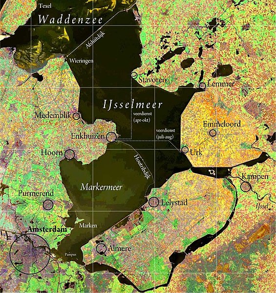
Walter Christaller gave the world the central place theory in 1933. Given the times, he sold it as the geographical realization of the Fuehrer principle for occupied Poland and it became the pattern how the settlements of the newest Dutch province Flevoland were placed. It shows very well how politics can hardly change geography and you cannot argue against physics. It was unavoidable for Almere to become the biggest suburb of Amsterdam, but Lelystad was placed as a centrally located political capital accessible from all directions. Given the title of this chapter, this is one of the few things you could actually call a new foundation and not just a proxy to it. Zuiderzee Works and Delta Works profoundly changed the Netherlands and Flevoland becoming the 12th province of the Netherlands in 1986 was no accident. Markerwaardpolder was never finished, however, and Marker Wadden is more about an ecological reconstruction of the place than any idea of settlement. Pampus may make a great target to relocate Asterdam Schipol Airport, yet its current location also arose on a polder, Haarlemmermeer.
565px-IJsselmeer_satellite.jpg

It's no accident either that any polder planned but not drained by the 1970s would never see the light of the day.
This is also the time when NIMBYs started to pop up everywhere. Saturation, boredom, post-materialism. Quod erat demonstrandum.

In German reality at least, a state will define planning regions with at least two counties but hardly more than four and designate places as lower centers, medium centers and upper centers with the bigger stuff also doubling for the smaller stuff and the upper center offering anything you'd ever needed from department stores to higher learning to a maximum quality hospital. In many cases, one city won't do alone for upper-central functions, so it's actually common to define twin cities as upper centers (e.g. Tübingen with its U and Reutlingen with its industry), it's even triple and quadruple cities in Bavaria.

Bavaria with its eternally governing CSU with its sense of mission and Bavarian exceptionalism even introduced two new levels beyond upper center in its latest state development plan from the late 2010s just to show it off: Metropoles as in Munich, Nuremberg and Augsburg (one for each Bavarian "tribe" to appease proportional representation) and regional centers as in Würzburg and Regensburg (creating a legal compulsion to never ever stop an ICE stopping in their main stations) and you may feel pity for Bayreuth and Passau not to get that promotion as regional capitals (with the great honor of e.g. hosting psychiatric wards besides their regional authorities and assemblies) and Ansbach just serving as a political regional capital instead of Nuremberg for whatever reason. In my native Baden-Württemberg, we're more humble and designate the Eastern Württemberg region (Schwäbisch Gmünd, Aalen, Ellwangen, Heidenheim) as having no upper center at all and its four medium centers being required to serve upper-central function as a quadrilateral tandem. D'oh. The blueprint for his theory was indeed Southern Germany and he included Strasbourg and Zurich into the rubble just as much as Frankfurt, Stuttgart, Nuremberg and Munich.

Bavaria as the second-most populous state of Germany (both historically behind Prussia and in modern times behind NRW) is closest to ideal of "Einräumigkeit" which can be translated as "one-space-ity". The administrative regions or governorates (Regierungsbezirk, Reg.-Bez.) which the state government uses to enforce the political will of the state is spatially congruent with the higher communal association (höherer Kommunalverbrand) which are called Bezirke which I just called regions in English. Before the German Municipal Ordinance of 1935 streamlined the designations of these entities after the Prussian model with Gemeinden being municipalities and Landkreise (or just Kreise) being counties, the Bavarian counties were called (politische) Bezirke as they're still called in Austria today and used to be called in Saxony also whereas these regions of Bavaria were called Kreise and the Bavaria State Constitution of 1946 still retained these old labels despite the changed reality. A county in Württemberg used to be called Oberamt ("upper office") and an Amt is a form of inter-municipal association between municipal level and county level in some rural northern states and also exists in others under a plethora of names, those in Baden-Württemberg and Hessen called GVV (Gemeindeverwaltungsverband or "municipal administration association"). That's German federalism at its best and that's beautiful. After the Congress of Vienna, Prussia itself divided its territory into Provinzen and Regierungsbezirke with examples of the former usually containing at least two of the latter and both being some form of governorates whose competences were hardly finally outlined until Prussia was dissolved and these provinces getting spatially congruent sister of higher communal association that were called Provinzalverbände (provincial associations) getting their own Provinziallandtag (provincial assembly/diet) with a Landeshauptmann (land chief, governor) whose title is also used today for state governors in Austria. The provincial equivalent of a regional governor (Regierungspräsident) was called Oberpräsident, "upper-president". The double structure in Prussia shows that it's always been too big and actually half of Germany and that such a governorate is best of the size of a small state of Germany and there should be several ones in bigger states. The provinces of Prussia mostly became separate states after World War II and NRW becoming one out of two provinces just had to do with having a combined liveable state of the entire Ruhr and the two provincial associations besides the five governorates were partially superceded by the Ruhr association RVR.

When Poland reformed its administrative structure in 1999, the new 16 voivodships combined both congruent Bavarian institutions into one with the voivod being the appointed governor representing the central government like a Regierungspräsident or an Oberpräsident, the local Sejmik being the regional assembly and the marshall of the voivodship as its elected governor like a Landeshauptmann. That's the beauty of doing it all from scratch. The former 49 voivodships that also had to work out without counties underneath them were more like oblasti in Soviet SSRs with its municipalities being like rajons. Prussia trying to have both the cake and eat it too with viable units on the one hand and direct territorial stealth on the other hand shows how stuff won't work out if it's all half-assed. The municipalities are divided into rural ones, urban-rural ones and urban ones that mop up the plethora of associations known from Germany from the start and there are, of course, independent city-counties as well.
800px-Schemat_polska.svg.png

If it's good enough for me, it must be good enough for you. If it's good enough for you, it must be good enough for me. (Courtesy of 2 Unlimited)

The French département system proved to be quite robust, only the Ile-de-France saw its two most populous départements split into seven as 5 million-ish people in Seine départment and 3 million-ish people in Seine-et-Oise département were deemed too big to govern and the smallest département still counts less than 100,000 inhabitants. On the other hand, planning regions turned into full-fledged subnational entities and reforms in the 2010s merged structurally week regions in metropolitan France into bigger regions to make them function and saw the introduction of metropoles as urban collectivities, inclusing Paris and its Petite Courunne with the latter seeing the construction of Grand Paris Express. So splitting the region around Paris was great for car plates, postal codes and phone numbers (the first and the last were overhauled anyway and the middle of them has another chapter in this thread and proved itself), but an integrated urban planning needed something different and that only came much later.

England in the UK saw the introduction of metropolitan counties and the extension of the County of London into Greater London whose organs were razed by Margaret Thatcher and only London getting it back in 2000. There was an attempt to introduce regions between the county level and the national level, but they were aborted because voters in North East England were against it. You should reconsider this and I mean it. Responsibilities have been heavily diluted to somehow "independent" or "autonomous" entities (I forgot the name of this stuff) that are paid for by the state and yet don't show who you've got to ask if you want something from them and I guess it's been on purpose due to Thatcherism. Taking back control is about naming clear responsibilites so that they may run but cannot hide.

Germany mostly saw fusions of many smaller counties into fewer bigger counties, in the late 1960s and early 1970s in the West and in the early 1990s and the late 2000s or early 2010s in the East and it's no coincidence that it's been in 2012, after the last reform of that kind, that car owners can have their old county code back for new registrations: Modern computerization and internet allows for one national code system anyway and if you only need to tell the DMV in the respective county office who has sinned instead of having to ask the DMV who that sinner is, it doesn't matter if one DMV has to manage multiple codes. The system should just be decent enough to assign any county code to one unambiguous county, thank you very much. Of course, you've still got municipal associations between municipal level and county level and often administrative offices between county level and state level and any of these bitches has got its own terminology in any state. Argh!


Jing-Jin-Ji with Xiong'an - New Town With Chinese Characteristics

Xiong'an is the Chinese attempt of a nation-level new town that's built as a relief for the nearby metropoles of Beijing (Jing) and Tianjin (Jin) to create a united metropolis of Beijing/Hebei (Ji), the project called Jing-Jin-Ji. It's beyond the Beijing-Daxing airport of a Beijing perspective (and accessed by said high-speed rail since the end of last year) and somehow halfway between Tianjin due east, Beijing due north, Baoding due west and Cangzhou down south. It's supposed to become and ecological and high-tech hub for the region and especially to downsize commuter times that are said to have added up to 2½ hours in one direction and therefore 5 hours in total every day. Stuff is deliberately to be moved out in order to make them more accessible for the ordinary comrade and the headquarters of the CCP are to become part of this as well in the long run and if only because the air will be better there. Jing-Jin-Ji, that's the beauty of Mandarin and other East Asian languages influenced by Kanji usage. It's way more practical than calling it capital region, urban Hubei or even something like "Ile de Chine" comparing it to French.

800px-Xiongan_New_Area.png

I remember how the German Diercke Atlas in its 1970s said that Tokyo has an "advantageous peripheral location" when it comes to aviation.
You could say the same about future Xiong'an that's supposed to fulfill the wish for high-speed rail connections under one hour among all of Jing-Jin-Ji.

The key here is high-speed rail and whereas the physical distance to the new estates of your old employer may not necessarily be closer than the old estates before, the travel time will because high-speed rail will bridge the biggest part of the new distances and drastically reduce the fraction of e.g. classical rapid transit constituting the respective last mile of O&D traffic. It's actually like creating a new center for the capital city outside the capital city, a new foundation so to speak and create express services in the green field that will become so much better than anything that could even theoretically be retrofitted into the existing urban settlement.

How hard it is to retrofit anything comparing the that into an existing conurbation is actually the Ruhr that wants to upgrade its RE (Regional-Express) network in the RRX, the Rhein-Ruhr-Express. What's not shown here is that five of the cities in the Ruhr and Cologne got their own LRT systems in the 1970s and the desire to mesh the insular Ruhr networks never came to fruition and the reason may also have to do with the fact that the LRT may be handy, but not overly fast. The RRX running every quarter hour in the core route between Cologne and Dortmund thanks to four tracks between said end points (and even six between Düsseldorf and Duisburg) is supposed to solve that problem in order to somehow move even more people from the car to the trains as it's the closest thing to an actually realizable super-metro in the region. Considering all of this, it's quite elegant by the Chinese to build the express services long before the conurbations will grow into one.


About New Projects And New Campuses

Americans may be completely lost here (and maybe some other Anglo-Saxons too which may take automatic dormitory places in their college/university towns for granted), but the classical college town is an exception to the rule in many places on Earth. When the post-World War II economic boom made for a substantial expansion of the student population per cohort, this also meant that new buildings were necessary to house these expanded institutions. If a town got awarded a brand-new alma mater, it was quite easily to build a new campus at the edge of the city. College cities could easily expand as they were already built with it in mind and state universities were often de-centralized anyway if they didn't have to become that yet. After the 1968 student protests in France, it was often decided to break up formerly consolidated city-wide alma maters into several ones with campuses at the edge of cities to disperse the revolutionary potential of these young people. Then you've got full-scale universities like those founded in medieval times that yet had to go with the times to offer the whole spectre of sciences and needed new buildings as their old ones became too small and outdated for modern standards of their purposes. A good medium, at least in German-speaking Europe, were the technical colleges turned universities that arose in the heyday of industrialization whose towns had time and opportunity to grow into them and yet were already of a size that expansions won't make that much of a problem. The Karlsruhe Institute of Technology arouse from its traditional technological university, now Campus South, and the Karlsuhe (Nuclear) Research center that used to have a so-called civilian clause that prohibits R&D for militaristic reasons, now Campus North and the biggest of the rubble, and whereas there are also other small scattered places used by the KIT, it's not nearly as insane as with its nearly 500 years older brother up north where Mark Twain described the cliché of the typical lazy German student. The most famous traditional university town in Germany is Heidelberg where I did my politology studies and that's besides the local teacher's college and the local polytech. This university officially features three campuses, Old Town, Bergheim and the INF in descending order of its age. Old Town is scattered all over the place and the university square is far from an integrated campus and it extends to the other side of the Neckar River where parts of the physics and the student council have their home, call it the East End of the U. Bergheim is also a hit and miss to call a campus and was originally used as a scattered medical campus of the U before they moved out to the INF and the old medical clinic became the social science campus with other philological stuff supposed to move in step by step after the old medical occupiers finally moved out into the INF and other health-related stuff like the local psychiatric ward are supposed to stay there and I like it as it makes me feel like home, call it the Centre of the U. The INF (short for Institut Neuenheimer Feld) was the post-World War II campus built beyond the river in the green field for STEM subjects and more and more medicine too, call it the West End of the U, stuff that just needs specialized room to be created and more than just desk jobs and the closest thing to a real campus in Heidelberg. Here you move out stuff that needs its special treatment for logistical reasons whereas the legacy structures can be retrofitted for less dangerous and dirty stuff.

There's a reason why outdated utilites are either turned into parks (because what's lost once will never come back and a park just needs free space, Görlitzer Bahnhof in Berlin became Görlitzer Park for a reason) or apartments (a loft is more easily turned into a dwelling that vice versa and access to transit is already there, I grew up between a cemetery, a hospital and a barracks and live with the aftermath), everything else is more complicated, needs an approval process etc. Institutions of higher learning are just the most special case of new foundations, satellite towns and such are the most classical post-World War II example and whereas new towns in Britain and villes nouvelles in France tried to follow approaches to a garden city ideal, that chapter would be incomplete without talking about high-rise housing projects that were deemed a promising thought of new living after the war and turned to acquire a reputation of being deprived areas where people could afford alternatives, whether deserved or not. Pruitt-Igoe was a prime example of failure, but most estates in the former East Block are populated by the average Jane Doe or John Doe. In East Berlin, new estates created a desire to create new boroughs for the rising population at site. Hohenschönhausen (known for its jail which I visited) was created out of pockets from Weißensee and Lichtenberg, Marzahn out of a sizable chunk of Lichtenberg and Hellersdorf from a chunk of Marzahn. Greater Berlin started out with 20 boroughs in 1920 which largely remained that way (and were the basis for the occupation zones inside Berlin) and the three new boroughs were the only bigger change until. If you read the Unity Treaty treating the merger of East Germany with West Germany, you will notice that there's a section 2 in paragraph 1 saying "the 23 boroughs of Greater Berlin constitute the state of Berlin" with section 1 naming the new eastern states to be created in the night when the East is absorbed. The boroughs in East Berlin were important in order to govern the place effectively, in a united democratic Germany, municipal governance also comes with budgetary responsibility and 23 were way to much from one day to the other. The state municipal reform of Berlin in 2001 turned 23 old boroughs into 12 new boroughs that each had to have at least 200,000 inhabitants and were, if they didn't already have 200,000 people from the start and left as they were, merger of old ones with none of them split in the process and only two of them transcending the old East-West border. Hohenschönhausen joined back Lichtenberg, Hellersdorf joined back Marzahn which became Marzahn-Hellersdorf as one of six new boroughs with a hyphenated name.

Because of the rapidly changing world after World War II, it's no coincidence that municipal reform became quite a hot issue in that generation and if you want to name a clear role model for the millennial Berlin reform, the creation of Greater London in 1965 comes into mind and there's a whole interesting video explaining the whole rubble. Yes, slum clearances and bombings left many poor people in Inner London (as we call it now, it was the County of London from 1889 to 1965) without decent housing and were largely moved out to new towns in the larger Southeast of England. Yet this population transfer didn't contradict the desire for an enlarged polity of London. Studies were conducted which parts of the Home Counties actually commuted into London and which were self-sufficient enough that continued autonomy still made sense. This outlined the rough borders of future Greater London. The 32 London boroughs (exlucing the City of London) with 12 in Inner London and 20 in Outer London made for the inner administrative borders. The 200,000 inhabitants per borough were introduced as a threshold for London in UK and became the blueprint for later Berlin. Experts had the opinion that 200,000 people were the ideal size for urban governance for whatever reason. Fire departments may come to mind, revenue services definitely and school boards, well. Citizens' offices also come into mind and my hometown in Germany has multiple boroughs that rotate their PM time services during the week and I can actually request a new ID or passport in any of them and decide where I want to fetch the finished document. It's about the perfect balance of closeness to citizens and whatever you can call the best cost-benefit ratio to employ specific public services. What I find most fascinating is how this Greater London Act made the capital city swallow the nigh entirety of a county from the map, Middlesex.


Is Every City Entitled To Docklands?

My own hometown is an example of a shipping town that used to have docks until the 1930s when we got our own canal (that doubled as our new harbor) that turned the area around our main railway station into an artificial island and most of our additional boroughs are at the other side of that canal. An automotive artery was built next to the canal in the 1970s and 1980s, a state garden show in the year I was conceived created a park at the southern tip of this artificial island where I boozed after my final Abitur exams with everybody else and also has a swimming pool near it. The northern part of that artificial island was razed to a great degree in the 2010s to make way for the federal garden show BUGA 2019 to re-emulate the lost docks and create a new ecologically correct neighborhood on the way. The river and everything around it is the closest thing my hometown has to a new foundation.

Maybe somebody remembers the urban planning thread and my PDF file for my hometown's LRT system. There's a theme with my colors, the western stations were held in blue because of the river to be crossed whereas the east has a more park-like character and its station were more held in green in that spreadsheet. The northern stations were held in shades of orange because they get into an industrial zone and brown to yellow was used for a hypothetical southern extension that's only a fantasy right now and supposed to constitute the last lacking cardinal direction. When I saw videos on YouTube about Crossrail and how reconstructing Connaught Tunnel just as drily in the Thames River as it's been built in its first place anyway, I had this picture in my mind that you could actually play the entire line as a jump-and-run game à la Super Mario World and who knows what would've been the perfect station for a ghost ship level. Canary Wharf? And when I saw a picture of modern St. Katherine Docks with its yachts at the end of its gentrification process, it reminded me too much of a modern video game, especially stuff like Patrician IV where the harbors are programmed to a degree to look like that even if some buildings have more similarities to the warehouse district in Hamburg from 1883 rather than medieval Hanseatic League cities.

I somehow came to love docklands even if I'm not an aquatic person. Maybe it's because it's the prime example of an industrial wasteland. First you need docks for the livelihoods of your town or city and you place them where they are handy and there's hardly a greater city which isn't at some kind of waterway, it's been the first motorway of humanity. Industry is growing, railways and streets run the place and the city grows in general and into the docklands in particular. There are limits in extending this infrastructure, especially residents that didn't even exist there back in the days and the economies of scale dictate that you need bigger units out there and if you can freeze your stuff on site, the docklands have outlived their usefulness and we say hello to the modern cargo terminal. One of the earliest warning signs about global warming was the fear in the 19th century that rivers are at risk of drying to a degree that you can no longer commerce on them. Most rivers saw some form of regulation anyway, but it's especially the railway that made direct water access for transport purposes largely obsolete. So a city that has intense docklands or at least waterways has a precious infrastructural reserve that it will have to play and will want to play.


Transdanubia and the Seestadt Aspern - Ein echter Wiener geht nicht unter!

The Danube River in Vienna was a very wild stream and there are four water bodies that can be called part of the Danube River hier. There's (from west to east) the Donaukanal (Danube Canal), the main arm of the Danube River, the Neue Donau (New Danube) and the Alte Donau (Old Danube). The so-called Donaukanal is the orographically right-most and generally westernmost modern arm of the river in Vienna and the place where Vienna was founded and 19 in 23 precincts of Vienna are part of this central dry part of Vienna. Precincts #2 (Leopoldstadt) and #20 (Brigittenau, out of parts from #2) are located between said small canal and the main arm of the river that was created with the Danube Regulation of 1870-75 and also saw a dam of inundation and what became the Alte Donau that used to be the orographically left-most and generally easternmost arm of the river in Vienna before regulation. That dam proved to be not effective enough which meant that the years from 1972 to 1988 saw the creation of a discharge canal called Neue Donau and the Donauinsel (Danube Island) between it and the main arm that became an important recreational place and the whole complex, together with the Alte Donau, constitute the precincts #21 (Floridsdorf) and #22 (Donaustadt) which are commonly called Transdanubien and fit in a fifth of Vienna's population.

donau_1373879740665656.jpg

Leopoldstadt used to be synonymous with its entire island. Floridsdorf has its own soccer club and an incinerator styled by Friedrich Hundertwasser visible from rapid transit.
100-year old "Red Vienna" has a great history of settlement policy, but the taming of its wild Danube River may have done half the job.

Regulating a big river has three purposes: Providing a deep solid course for the river, keep it that course at bay and also providing secure land to develop on. The island of #2 and #20 hosts the northeast-to-southeast part of the Vienna Connection railway from Handelskai via Praterstern (famous for its fairground) to Wien-Mitte (Landstraße) and it used to be overground before the regulation and was built anew underground during the regulation. Considering where it's been built, it's no coincidence and it's also no coincidence that this big island is the home to a soccer stadium. There are three U-Bahn lines crossing the various iterations of the Danube River, first the U1 in the middle, then the U6 up north and the U2 as the third and last one. The collapse of the Imperial Bridge in 1976 sped up the construction of the U1 over the Danube River as it's been integrated into the new Imperial Bridge from the start and is the most central line crossing it. The U6 up north was extended next in the 1990s in the vicinity of two existing bridges serving rail and car traffic each. The bridge for the U2 was the last of them all, built in 1990s for long-term U-Bahn usage anyway, but first serving as a road bypass for the Prater bridge to be overhauled, then serving only the public buses of Vienna and rebuilt for the U-Bahn in the late 2000s and reaching its terminus Seestadt Aspern before the settlement was built. There's also the Donauuferbahn (lit. Danube Riverside Line) running right there where the name says (and impassable for some days in early August 1976 because parts of the collapsed Imperial Bridge hit it) which is the last gap in a three-quarter ring service of the S-Bahn that comes with the merger of S45 (northwestern Vorortelinie) and S80 (southern Verbindungsbahn) and the full ring is supposed to be closed by the mid-2020s.

Aspern used to be the first reliably dry place at what became the Alte Donau and the airport "Flugfeld Aspern" was the interwar passenger airport that was eventually replaced with Wien-Schwechat in 1954 (Schwechat is not part of Vienna proper, mind you). The literal airfield was renaturated in a lake and the name of the U2 terminus translates as "lake-town Aspern". Before the U-Bahn was built here, and it's still not really walkalbe from the U-Bahn now either, the early 1980s saw the construction of an Opel car factory with about 2,000 workers. Seestadt Aspern is actually just up north from the Opel plant, but I guess most factory workers will still commute by car. And yet this second Danube Regulation that created this "New Danube" will have been instrumental in providing a geographically secure site for the Opel plant. Aspern is a role model in urban planning and shows what other German-speaking cities do wrong what Vienna does right. They have a combined concept how the ground-floor shops are supposed to be leased out, what kind of socially compatible mix of council housing, private housing and anything inbetween is supposed to come there and they didn't forget to build dormitories for Vienna's students also. Remember that you need to be a registered inhabitant of Vienna for two years in order to access council housing. Most important, however, is the fact that the subway came first and the settlements second. Rumor has it that "real Viennese" which means the lion share of Viennese people downtown wouldn't want to move to Aspern because it's way out there and most settlers have either already lived in Transdanubia before or moved from outside Vienna from the start. What's great for the dorm dwellers, however, is the fact that this U2 gets them non-stop to their desired U because almost all of them are near a U2 station in Central Vienna anyway and half an hour in the subway is a great amount of time to let your caffeine sink in. The medical U that isn't will one day get access to the U5 that's in the process of being split from the core of the U2.

PS: "Ein echter Wiener geht nicht unter" ("a real Viennese won't go under") is a 1970s Austrian sitcom about a working class family living in a tenement in the 10th borough of Vienna, Favoriten, dealing with real daily life problems and speaking the local dialect, the closest thing Americans may have gotten to this is Roseanne.


Ørestad and the Öresund Link - No Need To Re-Invent The Wheel

Copenhagen had jobs but a shortage of housing. Malmö is the reverse, what with being a depressed area since the shipping industry declined in the 1970s. Helsingør and Helsingborg may have been the shortest link between Denmark and Sweden, yet nowhere near so effective as the link between the Danish capital of Copenhagen and the southernmost Swedish city of Malmö. The idea was very old like so many others and yet needed until the 1990s to result in its construction with a grand opening in 2000. The island of Amager south of Copenhagen was convenient for such an endeavour, it used to be a place where people on death row were beheaded, it saw reclamations in its west in World War II that turned into natural recreation as it became home to Kastrup International Airport. It was also a convenient place to build the Öresund Link through it as it was already on the way to the polder Peberholm (pepper island, down south from the all-natural Saltholm, the salt island) that was created to bridge the gap between the tunnel from Amager in the Danish west with the airport that just couldn't have a bridge in a way and the bridge to be built in the Swedish east. It also created an opportunity to build Ørestad on Amager next to the airport and the nascent Copenhagen Metro opened in 2002 was built even before Øresund itself to connect it beforehand and in a way that the established S-tog commuter rail system couldn't, what with running a 90-degree angle to it and the opportunity to build an own new trunk line was just too good to be eschewed. The airport and the exhibition and convention center existed before, but the natioan broadcasting corporation moved in here, the concert hall, the shopping hall and the biggest hospitality business in Scandinavia. Just as with Aspern in Vienna, Ørestad for Copenhagen shows how intelligent urban planning can look like. First build the lifelines, then build the city or whatever settlement. There are actually cases e.g. in my native Germany where a whole new family-home settlement was built at the edges of Cologne and no bus is running there, not in America that is notorious for regarding public transport as a poor people issue and school buses being a necessary evil.

If you think about it, it should only be natural for a big city and especially a primate city to grow this way. If it can, so to speak, and instances that cannot are the biggest problem. The thing is that only three of the four realized districts have been realized in the first place and they're not continuous, but rather segregated into a north that's seen as a natural extension of Copenhagen proper and a south that's the only part that's considered part of Ørestad proper. The very last shout-out to an old classic at AH.com will see further elaboration where an extension gets political.


Paris Extra Muros - Nanterre-La Défense As The CBD Of France

This isn't really an aquatic and also doesn't have to be. There's a two-part episode of Le Dessous Des Cartes where they show how vulnerable Paris actually is against high water and, contributing to the French-German co-project ARTE, how the building code for Frankfurt am Main and its skyline could serve as a role model to reduce the potential damage. New skyscrapers are not allowed to have underground levels, the ground level is supposed to see sub-level use only (e.g. as a car park) and the floor of the first "regular" level in a skyscraper is mandated to be half a meter above a flood marker that supposed to be achieve once in a century with a probability of 0.5 percent. Anyway, La Défense shows how needs find their release valve and the city adapts to it and not vice versa. The RER A (the role model crossrail for the world as combatting the childhood diseases of Berlin and Hamburg in a global city that doesn't speak German) opened in 1977 also accessed Nanterre-La Défense which quickly became so important that Métro line 1 was also extended beyond the Boulevard Periphèrique to take over some of the load from RER A. This was also not enough. So in 1989, the French National Assembly passed a law to finance two new rapid tranist projects: The MÉTÉOR that became line 14 (non-stop between Châtelet-Les Halles and Gare de Lyon and the base for Paris Grand Express) and the EOLE that became RER E and their first northwestern terminus was (and still is in case of the latter) Saint-Lazaire terminal. Whereas line 14 would be a direct release valve in the very heart of innermost Paris, RER E is supposed to be an inter-northern artery bypassing innermost Paris and relieving it effectively. The last gap to be closed would be a tunnel between Saint-Lazaire and Nanterre-La Défense where a legacy Transilien line (commuter rail terminating in a terminal) would be merged with it. When it's finished, the eastbound 3/4 services mentioned in a post in the page of this thread would find their western terminus in Nanterre-La Défense (the reverse services would end in Rosa Parks as mentioned) and therefore count as the end of Paris intra muros for practical matters. RER A and RER E crossing each other at La Défense shows how important it is and make it the second city center of Paris and its first and foremost CBD. It's like an echo to the London Docklands that make the next chapter in this post. I actually drove to La Défense in 2010 and ran a full circe around the Arc de Triomphe before I could finally exit the roundabout without crashing anybody.


The London Docklands - How Greater London Became Great In The First Place

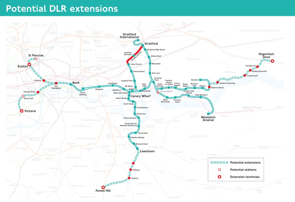
I guess everybody will have heard about "Unbuilt London" and especially the proposal to construct a straight canal thorough the Isle of Dogs to cut travel times on the Thames River and use the oxbow lakes created in the process as docks. Let's be thankful that this didn't happen because the land-water ratio would be way more abysmal. London didn't suffer from meandering like Vienna, but the tide from the North Sea has enough effect on the Thames River in London that the Thames Barrier was erected and the bend of the Thames River around the Isle of Dogs was maybe the most stabilizing factor of the entire river or at least its lower parts. What's been great for Vienna wouldn't have been that great for London and let's be happy that it didn't happen. It was way easier to keep the bend intact and build the docks around it and that's how the London Docklands arose. It's like having the cake of Vienna (lots of water per area) and yet eating it too what with being a stable bend. It was good enough to be in stable use as a dock and yet small and byzantine enough that container shipping was out of cards here and relegated to the Thames estuary. This meant that the entire place went out of business at once and now you have this city-proximate area where you could create stuff that a big city like London badly needs and didn't have the place to construct it before. The development of the Docklands manifested itself in a lot of things: Canary Wharf became the extension of London's financial industry and its docks are convenient for building new stations by creating a shell and pumping out the water, ExCel near Custom House is the modern exhibition center of London, the Millennium Dome that became The O2 is the modern concert hall of London that relieves the Wembley Stadium from doubling as such unless you really want to, King George V Dock became the basis of London City Airport.

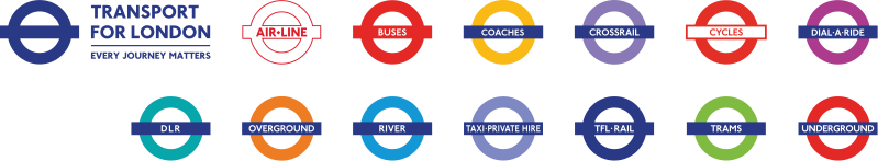
Between the end of the Greater London Council and the start of Greater London Authority, there was London Regional Transport and it used a streamlined version of the London Underground roundel as its sign as if the buses were the rule and the Underground was that minor exception that's still red enough with a little blue accent. Transport for London changed its generic roundel sign from that tradition red to the modern navy blue. Red and blue are both traditional colors of London, true, but the change from red to navy blue is very symptomatic and I guess this has a lot to do with the Docklands. The Docklands are to blame for four rapid transit lines/systems to be built this way in the first place. The DLR has its purpose in its name, accessing the Docklands and ironically started in the wake of the GLC's abolition. The Overground with the conversion of the East London Line from the U to the O was an attempt to regenerate the neglected East End in general by making it the focal point of its own railway system and the East London Line pierces under the Thames River in the western Docklands. The Jubilee Line, both in its old Fleet Line plans and how it's been realized in the end, is supposed to be a pipeline into the Docklands. Crossrail/Elizabeth Line is an old concept from the aftermath of World War II, but the southeastern branch was amended for the Docklands that clearly weren't in mind in the 1940s.

799px-Transport_for_London_-_Roundels.svg.png

The Docklands make the second CBD of London, the natural expansion of London and thus the expansion of TfL in its services.
Maybe it's a coincidence because of the alphabetic order, but having the original Underground roundel at the end is great, telling it's just one service among many.

There's a parallel between the 2012 London Olympic Summer Games and the 1972 Munich Olympic Summer Games: Building a lot of new sports venues was expensive, but was also needed... at least for Munich. In London, it's been about making the venues recycable and removable enough to move them through all of the UK to make them worthwhile and the olympic village was designed to become affordable housing for health and education workers, system-relevant people that hardly earn as much to afford London. And all of this was concentrated in the Docklands. And this is how the world got to know modern London with the Docklands as its natural waterworld, a legacy of Cool Britannia ruled by Tony Blair.

There's also a reverse parallel between London and Berlin: Berlin lost its natural center from a Western perspective with the division of the city and there was a desire from West Berlin to avoid passing through the East in Central Berlin and, more practically, access City West as its new CBD which was largely fulfilled by creating the U9 anew as a north-south trunk line and by extending the U7 from Neukölln into the rest of West Berlin. London found its Docklands rotting with container shipping making it obsolete and now you had this once-in-a-lifetime opportunity to extend London in a way that used to be impractical with the docks in the way and London satisfied lots of urgent needs in a way that the entirety of London desired easy access to the Docklands. West Berlin saw a coercion to face and London saw an un-coercion to face and that's how both Berlin and London saw the rise of a second CBD and that's how both cities came to feature pluricentric transit systems. Having this second center in London was a challenge for TfL with its monocentric fare system. In the end, the Docklands became a blend of both zones 2 and 3, officially labeled 2/3 so that all of the DLR is part of one zone and everybody needing the Docklands gets the best possible fare for their ride.

Transport for London knows a lot about branding and corporate identity and that's also a reason why there are three brands for rapid transit or equalable service at Network Rail in London instead of one consolidated RER London or S-Bahn London. Thameslink was just there and yet needs to be absorbed into TfL and the name stuck, Overground was a way to uplift underused legacy railway lines at least in their perception and Crossrail as the, ahem, "truest" deal of them all just needed an own name or brand. Maybe it's better that way because the Tube map is overcrowded anyway and having different colors for different trunk lines will remain desirable. The ongoing COVID-19 pandemic has, however, got away conveniently with the biggest obstacle for a merger of services: The franchise model was already in a crisis before and with the loss of passengers making it impossible to run them on budget, the UK government decided in 2020 to unilaterally change the franchises into concessions. Call it a legal or at least an economic expropriation, but this was the most discreet way to make the franchises pay their money back that they would've hardly ever paid back when still running. New TfL concessions demand public coffers to take over 98% of the gains and 100% of the losses, or so I read. You may ask yourself what's in it for TfL to leave 2% of the gains and run concessions at all instead of doing it all themselves. Well, private operators think about customer-friendly stuff like air conditioning or wireless internet that a state-run enterprise hardly thinks about and that's what this little incentive is for.


Berlin - So Much Water Yet So Little Reclamation

Reunited Berlin in the 2020s is also dealing with an un-coercion as Tegel Airport has been closed: The "Development Area Tegel Airport" as it's called in Berlin legalese will also become a factual new foundation and besides the construction of the Spandau Water City, the Siemensstadt 2.0 reviving the original Berlin HQ of Siemens into a digital hub (and the disused S-Bahn to be refurbished and extended to that water town), the Urban Tech Republic with Beuth University moving into Tegel Airport's hexagon and other exceptable redevelopment, this area is also supposed to house a new depot for the Berlin tramway that will become the first in former West Berlin after they axed it in 1967. The tramway is supposed to reach Jungfernheide and former TXL by 2027 and Spandau City Hall by 2029 and the whole rubble inbetween to be developed is supposed to receive a tramway network just as dense as the one in former East Berlin or what ever the election manifesto of the SPD promises, but it's great to build the tramway before any potential NIMBYs to object to it.

Talking about docks, there's the so-called West Harbor whose construction started shortly before World War I and went fully online in the 1920s and happened to be firmly in West Berlin later and used to house parts of the so-called "senate reserve" which was supposed to provide the needs of West Berliners for half a year in case of a new blockade of West Berlin and its dissolution was sent as humanitarian aid into the soon to be dissolving Soviet Union. If Berlin would've ever had a base for London-style aquatic ambitions, the channels inside Berlin where West Harbor was built wouldn't have been enough. There are major bodies of water inside Greater Berlin that became the state of Berlin and the maybe most suitable (because biggest) one for Docklands in Berlin would've been the Great Wannsee (yes, as in "Final Solution" Wannsee) which is also near Potsdam. This is inland navigation, however, and the closest German equivalent to London Docklands is the harbor of Hamburg whose future is secured by digging deeper the Elbe River (three times in the past) and there is no such thing as an Isle of Dogs in Hamburg and never was and this combination of a giant deep-water harbor of global significance with this hydrologically inauspicious geography where size issues could instantly frustate the purpose of this significance is an exceptional feature of London Docklands and who knows where something like this could ever the repeated. Definitely not in Berlin and that's why their inner-city harbor will not die, even if it would be nice to look at yachts in front of that warehouse or office building at West Harbor. You don't need docklands for the unearthed soil from Crossrail to ship it to a nature development area and the same is also true for the unearthed soil from the U5 extension in Central Berlin near the Spree River where the dirt was also filled into ships to sail it more or less directly where it's desired because dirt is heavy and in the way of anything else and here small ships will do, pig, they'll do. Have to do because the Spree River is not the Thames River.

The closest thing to a former harbor experiencing a non-dirty refrofit is the East Harbor in Friedrichshain (now Friedrichshain-Kreuzberg) that found itself right next to the Berlin Wall and became part of Mediaspree containing HQs for media and fashion. All of East Harbor became Mediaspree, but Mediaspree is still a bit more than just former East Harbor.

800px-Westhafen_%28Berlin%29_Administration_Building.jpg

Yes, this looks like lovely vintage real estate and we can imagine the yachts anchored here just as with St. Katherine's Docks in London.
But no, the world is no playground and somewhere work needs to be done and not every vintage building has outlived its purpose.
This is the administrative office of BEHALA, the "Berlin Harbor and Warehouse Limited Liability Company".


@Flocculencio with his Anglo-Dutch Empire and the nature of Imperial London

What if Wilhelm van Oranje-Nassau and his wife Mary had a child to continue their lineage? That's been one of the most classic timelines at AH.com and the author tried for an answer. There's been a lovely sketch on how Imperial London is supposed to look like what with the Imperial Palace being in Greenwich and the Imperial Parliament on the Isle of Dogs that makes the center of the Docklands. Well, this idea of East London or whatever you name it (and "national" London being only a small part in the central west) is definitely no accident. Where else would you build a new national capital in the vicinity of London without tearing apart the running affairs? Exactly. Imperial London ITTL is just as much a new foundation as e.g. New Delhi, Islamabad and also Darulaman and New Cairo IOTL even if it's inside political borders that will more or less equal Greater London of OTL. The idea may be very British as it's been realized in the Raj, but new nations states out of the former Raj and environs seem to have found a liking to it.

Similar to the university town of Lund near Malmö in Sweden, Islamabad was built in a climately auspicious place at a discreet distance to Rawalpindi, but still in a sensible proximity to Rawalpindi. The Darul Aman Palace was never used as a parliament building as envisaged, but it was used as the HQ of the Afghan Ministry of Defence in times of the Republic (1963-78) before it was burned down and whereas the new parliament building was built anew, it's not far away from the palace and the place of Darulaman is fulfilling its function as part of polticial Kabul. New Cairo on the other hand is built as an extension of Cairo to ease the pressure of settlement and is nowhere near enough for its purpose. This is actually the most sensible way to create a new political capital. Yes, the playgrounds of European imperalism may chose fully new cities in arbitrary places for political reasons (Washington DC, Ottawa, Brasilia, Abuja, Canberra, Dodoma, also Islamabad as a factual New Rawalpindi etc.), but I guess that the success of Saint Peterburg in Russia can hardly be copied and just like Paris with Versailles, Saint Peterburg got Tsarskoye Zelo that became Pushkin and the reverse is actually more respectable: Durlach used to be the seat of the Grand Duke of Baden when some Charles of Baden dreamt of a geometrically correct palace city that he called Charles' Rest or Karlsruhe and it became a reality and the similarities to the later built Washington DC are no co-incidence. Now Karlsruhe is a city best known for its technological university, the KIT, and its Campus South is in direction Durlach which has been absorbed into Karlsruhe.

Castles and stuff becoming parliaments and other government building are not new foundation, but to be taken for granted. This is also the case for stuff in Berlin where bombings and the division led to a factual new reconstruction of political Berlin. Yes, a lot of it clearly shows that it's been built after 1990, many institutions in Wilhelmstraße double both for Prussian and Reich functions, Prussian institutional buildings were rebuilt for the state of Berlin (the diet building) or the Federal Republic (the House of Lords becoming the Federal Council) and much of it looks and smells like a new foundation, but even a Welthauptstadt Germania would've been nothing else than a re-invention of an existing Berlin. What did they say? The war bombs would do half the job or remodeling the cities to our own likings. I don't remember which Nazi was credited with saying it, but somebody said it and the new political Berlin is a practical example.

After the Brexit vote happened, I came to think about how London could be retrofitted for global governance in a scenario where NATO and EU would be merged into a TTIP-scope Atlantic Union or whatever you name it. London would be Anglophone enough for the Americans and still be on the European side of the Atlantic Ocean. The UK could move its national politics up north (maybe Manchester) whereas the whole global governance stuff would go London. The buildings could stay where they are, but the new occupants would be international.
 
Last edited:
Memory Studies - Will They Ever Learn? And How?

Courtesy of The Economist from London (accessible without paywall) and Der Spiegel from Hamburg (behind a paywall). The English article is from before the pandemic, the German article is due to the pandemic.

This is, more or less, my second Coronavirus-related post here. Pandemics are black swan events that divide the lifetime of contemporary people into life before X and life after X. Americans know this too good with 9/11. Yet there are quite few of them and other ongoing pandemics of sorts are HIV/AIDS and malaria and it's been especially telling that one group of people rumored to have a lot of lockdown discipline to be desired in New York City are... young gay men. Is it forgetting the horror, is it pure spite, or what is it? It also didn't need long for so-called "COVID-19 parties" to arise or for the term to arise as a catchphrase to describe gathering of people that seem to break the lockdown rules and my first thought was, of course, bugchasing and the tent scene in Brokeback Mountain, the word "bareback" and, recently, that Germany's Green chancellorette-candidate sounds eerily similar what with her name being Annalena Baerbock, a literal bear-ram. But pandemics are not the only major black swan event. The closest thing to the lockdown measures against Corona in living memory are not the 9/11 flight security beef-ups (what with maximum amount of liquid in hand package), but the urgent advices to the population to avoid consuming the produce from your own gardens or to avoid letting your kids play outside due to the radioactivity in the aftermath of the Chernobyl disaster. I myself was just seven weeks old when that thing blew up. Of course, Chernobyl fueled an already vibrant anti-nuclear movement in Germany and after Angela Merkel managed to postpone some closings of nuclear power plants as of 2010, the Fukushima disaster in the aftermath of the Tokohu earthquake 2011 and sixteen days before state elections in Baden-Württemberg that washed the Green politician Winfried Kretschmann into government (ruling ever since after re-elections in 2016 and 2021) forced her into a U-turn and the exit from nuclear is taken so much for granted that current discussions about a similar exit from coal for renewable energy hardly see a mention that you could maybe extend the deadline for nuclear power plants to bridge the energy gap after a coal exit until renewables are reliable enough for energy provisions because that would be political suicide and that it's supposed to be a surprise that the young people from Fridays For Future are not as fundamentally against nuclear power as the generation before. Then you have this outright communist sub-group among this crowd, Extinction Rebellion, who tried (in a filmed instance) to convince people at a brown coal pit near Cottbus (supposed to be closed due to coal exit) deep in the east of Germany about the superiority of socialism over communism... in a place where they had this kind of "fun" for forty years.

You may say that anti-nuclearism in Germany follows a narrative: Some may argue that the neurosis that fueled the "blood-and-soil" ideology of the Nazis transformed into a bloodless variety after losing World War II that found an iteration in the anti-nuclear movement from 1973 on when winers were afraid that the clouds from the power plants may negative affect the sunshine for their grapes. Then came Chernobyl and boosted an already strong Green movement, then came the "nuclear compromise" that sees the "entrance into the exit" from nuclear power until 2022... only to be washed down again by a centre-right government that reversed this decision again with Fukushima. Human nature needs a narrative and that's why the pandemic won't as easily be remembered as 9/11 because there was no shock moment. Wars follow a narrative: Pearl Harbor, D-Day, Hiroshima and Nagasaki, the theme park version of World War II for Americans. I had a grandfather who became a captive in the Caucasus, near Baku where they also play some matches of the Euro 2020 these days. Panic buyings at the start of the first lockdowns (toilet paper being the #1 issue in Germany, other countries have other priorities) may have led to comparisons to the Cuban Missile Crisis, but the latter also followed some narrative that people were afraid of World War III happening which wasn't all that implausible and this story is retold thousands of times not just in history classes, but also in documentaries deep in the night. The Spanish Flu managed to get its token chapters in cinematic productions, but that may be because it's this little present that World War I gave to its aftermath. Yes, the villain among the military commanders in the Outbreak movie with Dustin Hoffman is casually talking about how his father lost three of his brothers to the Spanish Flu, maybe because it humanized even a guy like him. Yes, it makes a great narrative once again.

Let's get all scientific here: There is a difference between living memory and silent memory.

Living memory is what keeps people from doing the same mistake twice. One empiric example would be building higher above the ground instead of close to the water. Vaclav Fanta from the Czech University of Life Sciences in Prague and its Faculty of Environmental History did researched on civic engineering history along the Vltava River relating to high waters ranging from 1118 to 1845 with 900 villages and towns along the river. 2002 is not far enough in the past to already produce the final result and a big city like Prague will, of course, be rebuilt as quickly as possible and the formerly run-down neighborhood of Karlín can be blamed for the high water to be the best thing that happened to it. He found out that it took an average of only 25 years for people to build along the shore again which means merely a generation. The death of contemporary witnesses means the end of living memory and we have to remember that the average life expectancy before modern medicine is also to blame for this meager number. And yet it's proven that the memory of people can be manipulated deliberately and personal memories can often be misleading and this also means that the longer modern life expectancy will hardly stretch said number of years. If we talk about the anti-cosmopolitan backlash that resulted in e.g. the electoral success of alt-right or populist-right parties, Brexit and Donald Trump, you can also say that this has a lot to do with the way people want to remember the past and it often coincides with how people experience the present and the entire time in-between. If somebody says that high school was the best years of their life, it mostly means that this person is not living their current adult life right.

Silent memory is something way more subtle and lives on in the rituals and routines we employ ever since the event. Most proverbs and metaphers have some distant reason for their creation. The establishment of chicken kebap besides the ordinary beef kebap in Turkish takeaways is a far reminder of the first mad-cow disease case in Germany in late 2000. Most laws have a reason why they exist, but you'd hardly call them rituals and routines. Concerning the ongoing Corona pandemic, this could mean stuff like more remote working, Zoom (video) conferences, pop-up bike lanes supposed to stay (which they didn't in present-day Berlin) to combat overcrowding in buses, sneezing into the crook of the arm, the evolution from the ghetto fist to elbow-to-elbow greets etc.

Silent memory is less at stake as rituals and routines can be learned by example and become part of your child-raising. Fire drills at school and elsewhere are one example, Japan even has a dedicated earthquake memorial day to raise awareness that this can happen anywhere and anytime. Living memory is always at stake, however. The 2010s has seen some controversy about some measles outbreaks, how especially educated Green-leaning parents refuse jabs for their children on whatever anthrosophic grounds and that a country like Italy handled the problem by requiring vaccinations for any children to be enrolled in daycares and schools.
Back in the days, vaccinations were considered be a gift sent from heaven and that's how we got completely rid of smallpox and largely rid of polio. The very vivid horror of these diseases didn't make people question ask about any side effects. The benefits clearly outweighed the risk. As time passes, the horror is no longer in sight and therefore quickly out of mind. I never got a jab before Corona and therefore got chickenpox at age 4 and measles at age 10 and it's largely known that most adults born after 1970 never had a measles jab even if they got other stuff.

You see this with a lot of stuff. In analogy to flight shaming, the recent years have seen a surge of so-called pill shaming like "How can you KEEP on doing something like that to your body? And is the guy not just as supposed to pitch in as you?" and that there has been some drop in pill usage since the mid-2010s leading to a parity between pill and condom in some places. Women from 50 ago years (which is actually the early 1970s by now, mind you) could only be perplexed about this mindset as it enabled third-wave feminism and the sexual revolution in the first place and that there would one day be young women again that face criticism from other young women that they take the pill just because they don't want to get pregnant which is exactly the purpose of the pill. Yeah, I don't need feminism nowadays, bitches... well, until I feel the glass ceiling for real.

The fading of living memory was also an issue at the future-themed podcast by First German Television Tagesschau news Mal angenommen... (Let's pretend...) which is about thinking current news further and said issues asked "What if there are no more Holocaust survivors?" and besides the idea of creating holograms of aging survivors so you can still consume their contributions at the Holocaust Museum, Yad Vashem or straight out in a former camp, there was also the issue that racists, fascists, you name it, don't wait for the last survivors to die to deny the genocide and the behavior of Trump fans storming the Capitol to hamstring the formal confirmation of Joe Biden's electoral victory is considered proof of this.

The 2010s have already felt like a decade of Alien Space Bats and it doesn't seem to end here. That wicked stuff is supposed to happen in the fourth dimension (time-axis) as in the three others (space) warranted me to introduce the time aspect into this logistics thread. Oh, and if you have problems to argue about stuff you thought you'd never have to argue about ever again, well, read this opinion piece from Cracked.com (7 Reasons The World Is Full Of Hate Groups And Cults) for further sensibilization and why and how you should react to a good friend descending into whatever kind of sectarian madness of any brand.

Germany is actually doing quite well at the moment with single-digit incidence numbers. You may thank the vaccines for this, but just maybe it's also the great weather pushing people outside and providing the virus with less opportunities for indoor parties. We're afraid of a fourth wave that renders a normal start of school season 21/22 impossible. I already got my jabs in April and May and hardly have to worry about Delta, the UK and Germany plan free travel between their nations for double-jabbed people (and the UK is supposed to lose its current status as virus variant territory for the sake of double-jabbers that will lose the requirement to quarantine).

WHATEVER YOU PLAN ON DOING THIS SUMMER: PLEASE STAY HEALTHY!
 
The Literal Third Rail - Or Rather Lane

If you leave my hometown due south, preferably to get to the motorway to the next big city, you'll experience that the road goes uphill with two lanes and downhill in direction downtown with one lane. G-forces and lorries are a bad combination and that's why it's been built this way, uphill is always worse than downhill. 2+1 roads exist and will be used, overtake the slow frontman and so be it. Sometimes they've been retrofitted from three-lane roads so that any direction gets its fair share of overtaking opportunities, sometimes they've been retrofitted from two-lane roads to make overtaking possible at all.

This is the ordinary third lane for automotive purposes and ubiquitous in the world. It really gets interesting if it's about public transport. It's once again about underground railway, but here I'll discuss a vertical and horizontal purpose.


When There Are Just No Stairs - A Third Escalator

Moscow Metro is known for having third and fourth escalators at any station, the numbers of passengers justify it and it's good to have a spare wheel (or escalator) if one is broken and the direction just needs to be served. Nobody in their right minds would demand a solid stairway for this deep nosedive, but you need a spare wheel you can rely on. I've personally visited a way more humble iteration, however.

I've recently been to Berlin and also came to visit the "new U5" which is about the lately opened Museumsinsel station, but also about Unter den Linden station where the old U6 and the new U5 connect for a new interchange station. U6 at level -1 has side platforms inherited from the initial and perpetual location of the rails, U5 at level -2 has an island platform which also serves as a connector between the two side platforms of the U6. The escalators aren't nearly as long as in Moscow, but both sets of escalators (from/to any platform of the U6) are threefold, two running in one direction and one running in the other. That's because they refrained from having solid stairs between these two underground levels which wouldn't have looked very sleek and an interchange station deserves a great spare wheel. There are two elevators for that station, it doesn't matter which one you take for the U5 with its island platform, but it does matter for the U6 and it's side platforms. Uffbasse! (Dialect form of German "aufpassen", which means to catch up or to take care.)


MARMARAY ISTANBUL - The Western Counterpart Of The New Silk Road Meets Commuter Rail

You may argue about the rule of Recep Tayyip Erdogan any way you like ever since he ascended to rule after the 2002 general elections and the 2010s seeing the transformation of the parliamentary republic into a presidential republic. What you cannot ignore is that the last 20 years under the "new sultan" saw upgrades in Istanbul's infrastructure that were long overdue. Seven metro lines (M5 and M7 in Asia, the rest in Europe) and the Banliyö trains (the local crossrail commuter system) running on the new Marmaray rails, two in three of them to be exact. The third rail is for the great interconnection between Europe and Asia on standard gauge rail. The existence of the railway under the Bosporus is supposed to enable railway services in the region in the first place, but the literal third rail has a day and night time division of labor. Passenger services that are not Banliyö are supposed to run under the Bosporus in the regular daylight schedule whereas cargo is supposed run under the Bosporus exclusively at night.

What can we learn about this Turkish 2+1 system? I guess it's the best proof that Turkey was also at risk of running out of money and this was the cheapest way to both have a decent commuter rail system AND the great interconnection between the continents (or rather sub-continents). It's not been the only project, they also constructed a new airport at the Black Sea in Thrace and want to finish a straight canal by the centennial of the Republic in 2023 that provides for a bypass around the Bosporus and is seen as a danger to the Treaty of Montreux in 1936.

Turks in Anatolia have done their one fair share of the project, the Turkic peoples in Central Asia will have to do the other. The New Silk Road can actually be seen as the eastern counterpart of Marmaray to a degree. Streets and railways are the key here, but even if you can theoretically bypass the Russian gauge in Central Asia via South Asia, building new standard gauge tracks through Central Asia where they inherited Russian gauge networks from the Tsarist and Soviet eras is still prudent because it's more direct and topographically easier. Mixed-gauge tracks will be inevitable in a region like that.


CONCLUSION: The Third Lane Is A Perfect Symptom Of A Non-Perfect World

Stairs could be built, but who's supposed to use them in an emergency if they're usually out of sight and out of mind? It would be great to have four tracks or escalators, two in each direction. But good luck achieving the political capital to make it a reality. So the third lane is a clear case of a necessary evil: You cannot live without it because any two regular streams can break down and the public outcry is best to be avoided, but it's not loved.
 
Germany After Merkel - Some Miscellaneous Stuff At The End Of 2021

December 8th, 2021 is supposed to become the day when Olaf Scholz shall be elected chancellor, heading a tripartite government of Social Democrats, Greens and Free Democrats which is called a traffic-light coalition. 16 years of Angela Merkel have also meant 12 years of grand coalitions (shortened into GroKo from 2013 on as the historic exception became the rule) which ironically meant that social-democratic policy could be continuously implemented under a conservative head who always argued with psephological surveys after Gerhard Schröder failed to get reelected in snap elections that he provoked after losing state elections in a row after his own New Labour-style reforms (Agenda 2010) made his party lose its base to a major degree. The SPD was just quicker in its meltdown, CDU and CSU have already followed in these footsteps and the resignation of Merkel as a party chairman just made it all painfully clear that the lack of Merkel also became a lack of reason to vote her party. The reasons for that have long become common sense in politology and have been discussed in the political chat at this board for ages, so I don't see a reason to reiterate the obvious. What I won't write about here (as it's a subject for the Chat section) is the fact that I like how they ditch Section 219a of our criminal code that deals about seeking information about abortions, how gay men can freely donate their blood like hets, how cannabis will be legalized for adults, how the spousal privilege will be ditched for taxation purposes in favor of a family-friendly regime (maybe like in France where two children count as much as a marriage certificate in Germany until now) as Merkel famously declared same-sex marriage as a "decision of conscience" so that 75 of her MPs would vote for it in order to be done with it to ease coalition talks after 2017.

This thread is about logistics and the only reason I'm opening this can is the allocation of ressorts to the several coalition partners, especially how some specific ressorts have been divided among the parties that in other times may have better been put together. That's why I write here about it.

It's best to start with the Greens as the bigger junior partner. Annalena Baerbock as the top candidate of the Greens will become minister of foreign affairs (she's got a degree in public international law, mind you), which is actually the traditional top ministry for a junior party in a classical two-party federal coalition in Germany. The kicker is that the foreign minister traditionally doubles as a vice chancellor which Ms Bearbock won't, this honour will go to her inner-party rival Robert Habeck who will receive the head of a new super-ministry combining Economy and Climate. Here in 2021, the combination of economy and climate is supposed to prevent mutual sabotage of divergent interests in both matters of affairs. It may have sufficed to have both matters in one party, but Habeck is supposed to become the real man behind the man, hence his vice chancellory. Other Green ressorts will be Agriculture & Nutrition, Family & Seniors & Women & Youth and, of course, Environments. Green core issues shouldn't be sabotaged by e.g. an economy minister under the auspicses of the Free Democrats. That's why. The last time Germany had a ministry dubbed as "super" was in the second Schröder cabinet (2002-5) when party friend Wolfgang Clement headed a ministry of Economy and Labour. Then it used to be a matter of the economy people working against the habits of the labour people in order to implement the Agenda 2010.

Next is the smaller junior partner in form of the Free Democrats. They'll get Finance, Justice, Traffic & Digital and Education & Research. Those are all liberal core topics and therefore just fair to award them to. Well, more the digital stuff than the traffic thing which is usually the playtoy for the senior partner, but the rest will do.
Finally the senior partner in form of the Social Democrats will get the Chancellory, Interior and Homeland, Labour & Social, Defence, Health, Construction and Development Aid (literally "economic cooperation and development"). There's a lot of classical stuff in there, especially interior and defence for the senior partner.

The construction ministry isn't something too alien, but it's become unusual to be a stand-alone thing as it's usually combined with e.g. traffic. On a local scale, you shouldn't plan a new neighborhood without at least providing for a public transport stop and there's a thing called spatial planing on a larger scale. Here we see a divison of an idealy combined thing into several ministries and parties. But why?
Well, Construction here is about the social profile of the SPD which it seemed to lack after Agenda 2010 which is now all about affordable housing.
Digitization is, of course, a core issue of the Free Democrats that as a party morphed from the accountant image up until Guido Westerwelle to a start-up image under Christian Lindner and communication is a form of infrastructure like traffic.
The most important thing here is that Traffic wouldn't go to the Greens. They already got Economy in their portfolio, so the Free Democrats at least didn't want to sacrifice Traffic to the Greens and the Social Democrats got their Construction. So?

In the 2000s and 2010s, stuff like traffic and construction did indeed get together because new roads and stuff needs to be constructed after all. They separated ways after 2013 again in order for Traffic to remain in Bavarian CSU hands. In the end, every German federal government also possessed a "chancellery minister" that's supposed to streamline the diverging interests of the ministries in cabinet work. Frank-Walter Steinmeier, the current President of Germany and mostly acting as a figurehead, started out as a chancellery minister under Schöder and became the first foreign minister under Merkel.

And you see how it's got to do with logistics? You may think that only transport had to do with the ecological transformation of the world. But transport only links all that other stuff together and coalition arithmetics is just that. Construction would also belong to that because of the CO2 footprint and especially the recycling of a new building after it will have aged. And fueling the economy and combatting the emissions from livestock shows that this goes through the entirety of portfolios. So the Greens can as well do without construction and transport if they can get the juicy core stuff.
 
Last edited:
Let's Talk About Life And Death: An Update For 2022 Quarter 1

This article is sponsored by Vladimir Putin who opened the second phase of the Russian-Ukrainian War on February 24th, 2022 after the first phase already started in 2014 with the annexation of Crimea and the invasion of the Donbass.

Where there is a will, there will always be a way. That's what we say in German and one commentator on Twitter rambled that the Ukraine managed to set up a full-fleshed online school in two weeks whereas Germany with its 16 states didn't achieve in three years of Corona. Old people and car drivers are potent voters whereas children are not. And schools are currently the biggest Corona hotspots with Germany turned into the hotspot of Europe due to the Omicron variety and the states of Germany want to continue some anti-Corona measures after their inclusion into the federal Infection Protection Act reaches its built-in shelf life at midnight between March 19th and 20th leading to a byzantine mess of Corona measures across the country again. France plans a big bang, but there will be some vestiges left: Riding vehicles for public transport in France will still require you to wear an FFP2 mask. Bombs won't be an issue in 2022 Paris and that's how I say welcome to my next post.


The Friendly Bomb Shelter Around Your Corner - Rapid Transit Stations As Bomb And Nuke Shelters (And Targets For Terrorists)

There are three active metro systems in the Ukraine: In Kyiv, in Charkiv and in Dnipro. And there's the sealed construction site of a metro system in Donetsk that's currently outside the effective authority of the Ukrainian government. Kyiv has three lines and six arms stretching out from the interchange triangle, let's call it fully developed. Charkiv has three lines and four arms stretching out form the interchange triangle, meaning that two interchange stations also serve as termini one line each. Dnipro has exactly one line. Donetsk has one line under construction that's on indefinite hiatus. Kyiv is clear, it's the cradle of the Kievan Rus, it's been the capital of the Ukraine for most of time and it received the third metro system in the USSR after Moscow and Leningrad in 1960. Charkiv was the capital of the Ukrainian SSR when it was founded in the Russian Civil War and whereas the bourgeois forces of the Ukrainian People's Republic were ultimately crushed by 1922 when the USSR was proclaimed, it took until 1934 to move the Ukrainian SSR's capital from Charkiv to Kyiv. Enough time for Charkiv to grow and it got the second metro system in the Ukraine by 1975. Dnipro and Donetsk are only interesting for further mention that they exist, if nothing else.

Even before the discovery of nuclear fission, Moscow Metro was built to double as a bomb shelter in the likely case of war that came with Operation Barbarossa in World War II. Leningrad had ground water issues leading to the deep nosedive when riding its metro system (not that Moscow were really shallower) and the experiences with World War II, the conscience about instant sunshine having become a reality and the expected application of this sunshine in a hypothetical World War III led to the widespread adoption of super-deep fallout-proof underground stations across the East Block. Kyiv fits the bill perfectly, Charkiv less so. Just as Leningrad's ground water and soil issues demanded very deep digs to provide a safe and solid environment for tunnels to stand, Charkiv was the reverse case where the ground water was just at the level where other Soviet cities built their metro systems on purposed. So it's not all that deep (20 meters instead of 50+) and two of its three interchanges in the typical triangle are also termini which shows that it's structure is not maybe ideal for the Soviet triangle. And you may actually wonder if 20 meters are deep enough to make a great nuclear fallout shelter if things become earnest. But it still does as an ordinary bomb shelter and that's where Charkiv won't be worse than Kyiv and if you live in one of these cities, you don't travel to the other city if there's a bomb alarm, you dive into the next available hole!

In Western cities, it depends. London Underground was used for government purposes during World War II and was maybe the most secure bomb shelter during the Blitz even if it wasn't designed with this in mind. The German occupiers retrofitted the Métro de Paris against chemical weapons and the Résistance cut the telecommunication lines in the Métro in order to accelerate the German defeat in the liberation of Paris. Hamburg in modest scale and West Berlin in grand scale built bomb and nuclear shelters with a number of new underground stations as they were already at it. This stuff may all be cool and dandy, but they won't protect you against the occasional black widow bombing herself into suicide on your ordinary commute. Moscow Metro is considered an almost traditional target for domestic Russian terrorism. The 7/7 bombings in London were also executed in the Underground. 1995 wasn't just the year of the last French nuke tests in the Mururoa atoll but also the year when Algerian Islamists bombed its underground railway system, whether at the Métro or the RER. The last big Western attack in a subway system was 2016 in Brussels where the byzantine federal system (Communities and regions may overlap in all of Flanders and most of Wallonia, but not in Brussels which is its own region but no own community) hamstrung a more effective prevention of the attack that in its execution was already plan B as plan A was uncovered well enough to ditch it for the subway attack. And, of course, 1995 was also the year when the Japanese doomsday cult group Aum Shinrikyo gained worldwide fame with the Tokyo subway sarin gas attack.

My Chemical Salvation
The Japanese Coup of 1995

TERgj8i.jpg

It all started in 1984 with a yoga and meditation class given by 29-year-old Shoko Asahara, a student of esoteric Buddhist, Taoist and Christian traditions, with a growing family that needed supporting. The class grew and, by 1989, it gained official recognition as a religious movement, with its main demographic in college graduates. The group called themselves Aum, for the Sanskrit syllable that represents the Universe. They were considered odd, but not dangerous, and a part of the growing eccentricities that the Japanese bubble economy was creating. And, as it was, the group adhered to that aspect of their origin, adopting themes that were popular in manga and anime, such as space missions, international conspiracies, powerful weapons and a quest for an ultimate truth to spice up their creeds. To appeal to the modern, cultured Japanese man, they quoted ideas from Buddhism, the Bible, and from the great Isaac Asimov.

A monastic order was established for the followers to join, with a base in the village of Kamikuishiki, which would become the epicenter of the cult. Many would join the order as lay members. Shoko Asahara would write books, appear in magazines and in television, and give lectures at university, all of those giving the movement further credibility and helping it reach more followers, who dedicated their lives to it. There was even an anime made by the cult's studio, presenting Shoko Asahara as the reincarnation of Jesus Christ, as he had concluded himself to be.

As the following grew, so did the controversies surrounding it. Rumours came out of recruits being deceived and even extorted, and a prominent lawyer who opposed the religion disappeared mysteriously with his family, with his colleagues pointing the finger to Aum. Leaders of rival sects and critical people would also be assassinated or disappear, with the group being always suspected, but never proven guilty.

By the end of 1994, the group was preparing for its greater task, by amassing weapons, conventional and otherwise. Their favored tools were by that time already chemical and biological weapons. In Kamikuishiki, they started producing VX gas and the sarin nerve agent, while they also accumulated anthrax for offensive use. Throughout Japan, enemies of the cult were followed and used as test trials for the weapons, proving just how effective they could be. The most daring attack would be in the city of Matsumuto, where a trial was taking place surrounding a real estate dispute with the group. Using the sarin nerve gas within the city's courthouse, they were successful in killing some 500 people, and injuring many others. This was enough proof that the chemicals were ready for combat. The group was ready for combat.

On March 20, 1995, the great plan was set into motion. The Tokyo Subway was filled with the sarin gas, entering the lungs of the thousands of commuters following their routines as usual. With just that attack, six thousand people would die, and many others would be injured. Taking the entire Japan by surprise, the group moved towards the government building, seizing them under threat of further attacks; several neighbourhoods were sprayed by poisonous aerosol with an airplane the group had somehow acquired. It was brutal. In the following weeks, similar attacks and takeovers would happen throughout Japan, as the cult proved just how well-organised and well-armed they were. Unafraid to resort to either chemical or biological weapons, they proved the full power of their ruthlessness - 4 million would die in this campaign, to the cheers of the members of Aum, who truly believed that they were doing the work of God.

The Imperial Family and the political leaders were executed on national television, and the Enlightened Republic of Japan was declared, with Sonshi Shoko Asahara being declared Supreme Leader, as the Reincarnation of Christ. And so began in earnest his reign of terror. As Aum militias took over the military, a strict regime was imposed that brought down much of Japanese culture in deference to proper religious behaviour; shrines of rival sects were destroyed and their leaders killed. Deviancies were punished harshly. Ties with foreign countries were cut, especially the US, the Beast of Revelation according to Aum; trade ties would later be resumed with other countries, such as China, who couldn't care less for what mode of government the Japanese chose as long as trade flowed smoothly, but this trade was now strictly in government hands. Japan was, for all purposes, in splendid isolation once again.

And the most terrifying part was how easy they managed to bring large swathes of the people to support them. A great campaign of propaganda was thrown, with rallies, television shows and billboards announcing the triumphs of the new government. The youth in particular were brought in line, using manga, anime and video games to spread the ideals of the group. Youth groups would form the backbone of the State apparatus.

Ever since, Japan, once believed to be the thriving center of the future of technology and industry, has been under the strict rule of Aum and Sonshi Shoko Asahara. The few dissidents who escape tell the most horrible of tales, of a State that uses mental manipulation to the maximum, where every aspect of life is controlled and supervised, and where the terror of chemical burns and of the anthrax are frequent to leave one thinking twice before opening their mouth. Very little is known of what happens inside the country, however, as the government is quite secretive and their communications esoteric. It is known an extensive natalist program has been increasing the births in the islands, and industry seems, amazingly, to be thriving. How long this will last is unknown. But suffice it to say that the DPRK is no longer the strange kid in the neighbourhood

____________________________

Well, that was dark. I stumbled upon a video about this particularly nasty cult and decided "Hey, wouldn't it be interesting if they actually took over and formed a State so theocratic that would make the Ayatollahs blush? Then I went research what kind of weapon caches they had, and since apparently OTL they had enough chemical agents to kill 4 million people and, by default, they'd have to be even stronger in this scenario, this ended up being the result. It is terrifying.

I did not find much information in what they *believed*, beyond being a mix of apocalyptic Christianity-Buddhism with some weird esoteric meditation techniques, but then again, just looking at the way they worked, I can't imagine there'd be much sanity involved in whatever they'd do if they had the opportunity to do anything more than the damage they already did OTL.

If anyone is wondering, I used the jarring colours and weird patterns as a way to express the utter madness involved in this entire scenario. I hope it came across. Now if you'll excuse me, I need to go watch kitten videos until I remove the darkness that working on this created on my soul
This looks oddly appropriate in hindsight. Then again, this is AH.com which is like the Ikebukoru of Crazy Town.
Ikebukoru? It's a hotspot in Tokyo known to be less glary, more sedated than Shibuya. Call it the MILF of Tokyo.


"The Sorrows Of Young Werther" or What Goethe Has To Do With One Unders And Platform Screen Doors

The novel about the young Werther brought international fame to Johann Wolfgang von Goethe. National fame came with Götz von Berlichingen who's quoted with the so-called Swabian greets "But he, tell it to him, may lick me in the arse" which is where German "Leck mich am Arsch" or "kiss my ass" comes from. The novel deals with somebody whose sorrow lead him to suicide and it's the first recorded evidence of copycat suicides as its committers dressed just like the young Werther so described. Some places know about gentlemen's agreements that local news sites won't report about actual suicide cases in order to avoid copycat suicides. The first time I've been confronted with suicide in popular culture was some anime stuff I watched on MTV and this must have been at the turn of the millennium in my own childhood room on TV. You hear how somebody thinks about doing it... and then actually jumps... and that anime came to my mind again when I read about the Werther effect. Oh, and when we had Japan in 8th grade geography class about the Lost Decade in Japan (the school season was 1999/2000), the teacher showed a report on VCR showing among other things an actual One Under... besides a comatose family father after an aneurysm that could be said to be a karoshi (death by overwork) without fully dying. Not the gory details, but enough to show first aid personell running to the site. One way to stop people from jumping or falling into the tracks by accident, to commit suicide or to outright get murdered are platform screen doors. It's easiest done when you inaugurate a whole new line and conceptualize the platform screen doors position-wise to the expected rolling stock. Retrofitting is hard if you have versatile stock whose doors opening at different points. At skyscrapercity.com, some people argued which service as the first really autonomous rapid transit and there were arguments about what constituted as the "real" thing instead of some kind of toy. DLR is older than Paris Metro line 14 is older than the retrofit in Nuremberg that won't even feature platform screen doors. You don't actually need them, the autonomous rolling stock merely needs to be just as safe as a humanly operated train because if you jump into the track from a stand when the train rushes into the train, there's no way even an automatic trains can stop quickly enough. But you can say that automated trains were rolled out in "less tricky" systems first and the principle then trickled down (or rather rose up?) to bigger systems where the risk for passengers raises at least by number. I never researched, but I think that there are hardly (I don't mean definitely, just hardly) other examples outside of Nuremberg where this quick-and-dirty approach has been done: Manual and automatic trains in tandem in order to phase them in in the first place and not even bothering with platform screen doors. You need some serious trust in people not pushing each other or themselves in the tracks, but I guess experience is the key here.

In this year 2022, the line D of Prague Metro is supposed to get its construction permit. It will be the first fully automatic line in that system and, of course, feature platform screen doors at every station from the start. Fully in line with that article, I'll tell you my theory on why the maiden line of Prague metro got the letter C instead of A. Just like anywhere in the East Block, they planned a triangle system and the street network in downtown Prague just fit to it. What became line C was like an alien body to the system in some way. It was designed to become a light rail, having streetcars running in a tunnel and returning to the surface in the outskirts. It was only in the year after construction started that plans were overturned into a true metro system after the Soviet role model. This also meant that the existing construction site couldn't magically be moved 50 meters underground just for the hell of it and the most defining feature of that line is a two-story Nusle bridge featuring both a motorway at the top and the underground line at the bottom. So it was an odd man out, never to become the nuclear fallout shelter line that the "ordinary" East Block metro line is supposed to become, so it's easy to see how the last letter C in the triad could've been chosen to reflect this fact: A and B are supposed to become the real deal whereas C is the thing that you just put up with, it's the most necessary evil in the metro system. Oh, and half a year ago, the expansion of Prague's southwestern railway into a four-track line has been finished with the second of two new railway stations opened. This is great considering how my maiden hotel in Prague where I lodged again recently is way more accessible now: If the metro drivers and tramway drivers from DPP (the Prague transit authority) go on strike, I take the Esko. If the train drivers at Czech Railways go on strike, I take the metro or the tramway. Here you can see a video about the nascent interchange station I've been talking about. It's fully built to serve all four tracks, but you usually only need two hear. So yeah, it's only local services here, but you could offer long-distance relations at that station (and the other one in Eden at Slavia stadium) on the fly if so desired.


Meanwhile in London - The Elizabeth Line aka Crossrail Will Finally Go Online

Something more cheerful is going on in London. Paddington to Abbey Wood is supposed to go online the next few days and whereas a true through-routing will only happen next year, the thing will actually be usable now and at least service one purpose: Accessing the Docklands like an own underground line with decent interchange opportunities. This means that there will be three separate and isolated TfL services calling themselves Elizabeth Line. It may be prudent for ongoing operation seasons of the two older "legacy" services to find an organized end, but looks like remaining an alien body in the network. The through-routing in 2023 is important to fulfil the second and third purpose: Accessing Heathrow Airport like an own underground line with the decent interchange opportunities AND empower people from outside London to choose any central station as their personal terminal where they directly interchange to their desired tube line. I quote the post from the urban planning thread here and you see how dynamic displays show you a counter-intuitive way out in order to divert passenger flows to unclog them from the start.
The Elizabeth Line (Crossrail) is going to open in London in the next few days. Here's the Press Day preview with Public Transport vlogger Geoff Marshall (famous for the UK vlog 'All the Stations, where he visits every station in in the UK).


Meanwhile in Stuttgart - Take The Line Of Least Resistance

Welcome back to my state capital. There's the so-called Rosenstein Castle hosting the local Museum of Natural Science up north in Stuttgart upon a hill. There's the so-called Rosenstein Park next to the tracks leading to the legacy terminal of Stuttgart Main Station. One of its feeder lines uses the Rosenstein Bridge and Tunnel. Both will be replaced. There will be a new Neckar Bridge that will feed into two new tunnels, the new Rosenstein railway tunnel providing an extension for the existing north-south crossrail (and a new S-Bahn station Mittnachtstraße for a new neighborhood) and the new Tunnel of Bad Cannstatt that will access the regular railway into the new deep-level station, all of this is part of the Stuttgart 21 project. This Saturday, March 26th has seen the grand opening of the central element of a yet semi-finished project, this element being the Rosenstein automative tunnel. This is not part of Stuttgart 21, but right in the vicinity of the mentioned railway projects and it re-routes the B10 away from Pragstraße [1a] and Neckartalstraße [1b] around the Wilhelma [1c] into it. What causes some dismay is the fact that this relief will attract additional traffic, especially from the motorways if they're jammed. Stuttgart is touched by motorways from the west and north with the BAB 81 and the south with the BAB 8. There is no motorway in the east, but the new tunnel will turn the B10 into exactly this kind of tangential, crossing the BAB 81 up north at Stuttgart-Zuffenhausen (home of Porsche car works) with a course via Bad Cannstatt and the Neckar Valley into the southeast where you can choose where to touch the BAB 8 again, maybe at Wendlingen via B313 where the high-speed rail to Ulm has its starting point, also part of Stuttgart 21. I said semi-finished because some additional legacy tunnels near the Wilhelma-proximate mouth of the Rosenstein automotive tunnel are currently undergoing an upgrade, one is the Leuze tunnel leading to the B10 and B14 in direction Esslingen am Neckar (continuing the tangentail aspect), the construction of a third Leuze tunnel for getting rid of the B14 turnpike near the mentioned new mouth and direct access from direction Esslingen am Neckar into the Schwanenplatztunnel [2] that's also seen an overhaul and houses the access to the inner-city part of B14. Leuze is the site of Stuttgart's thermal springs. Some parts of the "old B10" which is the two streets around the Wilhelma are supposed to be reduced for automotive purposes in favor of pedestrians and cyclists, the pier of the "Neckar Captain" ship route and an exterior compound for the Wilhelma.

[1] The Wilhelma is the zoo of Stuttgart or, more explicitly "zoological-botanical garden" and the Marco Polo travel guide for Stuttgart in its last page called "Just Don't" (Bloß nicht! in German) features among other don'ts this one: Don't talk about the Wilhelma as "the Zoo" because it's more than that, people call it the Wilhelma. From Prague Street, you can see the glass roof of the Amazonia House of the Wilhelma and a side entry. From Neckar Valley Street, you can see the main entrance of the Wilhelma where they also rebuilt the LRT station.
[2] If you leave that "swan square tunnel" due south and turn left, you can get to the SWR in Stuttgart, the local studio of the bi-state Southwest Broadcasting Corporation. And to the hospital where I got my bariatric surgery done. The tunnel complex connects the north of Stuttgart with the east.


The Name Says It All - Welcome To Nusantara, The Capital Of... Nusantara?

Nusantara (not to be confused with Nursultan in Kazakhstan) is an Old Javan word for "outer islands" or "in-between lying islands" and is practically a self-description of the all-Malayan homeland, better known as Malayan archipelago and a shorthand for Indonesian national unity and the name of the new capital city to be constructed in East Kalimantan. Jakarta is known to be sinking under its weight and this is the reason why Indonesia is the newest kid in the club of nations that move their capital city. They want to start digging this year, move first institutions out there by 2024 and the process of completion (i.e. complete abandonment of Jakarta as a capital city) is supposed to take about 20 years into the 2040s.

Twenty years sounds like a good estimate, the so-called Capital Decision of the Federal Republic of Germany envisioned a movement from Bonn to Berlin in eight years and yet most administrative jobs are still in Bonn whereas most ministries have their so-called first seat in Berlin, the second seat of the ministry is always in the respective other B-town. West Germany grew accustomed to the provisional capital city that felt less and less like a provisory right at the moment when the Iron Curtain fell. If you never knew anything else than a divided Germany, grew up in the West and didn't feel that Berlin was in any way closer to you than Bonn, then you voted for Bonn. Otherwise, you voted for Berlin. I was a small child back then and didn't remember the details of these politics live. You may be tempted to think like a tourist if you're a child and think that moving the government attracts investments to beef up what's been neglected, but it's hard to reconstruct your inner child.

The big difference is that Jakarta is becoming untenable for multiple and fails due to its nature as a megacity in a newly industrialized country. There is consensus that there's a need to move the capital city out and the question was just where. Germany was a case of coming home for political reasons and Bonn was in the process of becoming fully functional. In reality, the abandoned buildings found new occupiers that filled the void and concentrated stuff that would've otherwise been dispersed.
 
Last edited:
A Map In The Mirror (Part I) - New York City As The Most European City In The United States

Or whatever you name it, people in New York City are usually no owner-occupiers and don't drive a car to their work. They live in tenements with rent control and take the subway to satisfy their needs and desires. I tried to compete in a Map Of The Month contest with an entry called "Big Apple Crossrail" that's, of course, been abysmal. New York City has its subway which is great at connecting its center in Manhattan with the outer boroughs. It's anything but great for cross-borough connections, however: Staten Island is the forgotten borough, the western shore of the Hudson river belong to the State of New Jersey, the G line exists but isn't that effective at interconnecting Brooklyn and Queens and the Bronx is, well, the Bronx. And don't get us started on passing through Manhattan without stopping or interchanging there! There is a deficit in orbital connections just as much as in cross-Manhattan connections. The biggest improvement in its newer history (post-1940 after consolidation) is the construction of the Chrystie Street Connection for direct connections between BMT lines in Brooklyn with Midtown Manhattan instead of just Lower Manhattan, also tearing down the barrier between the BMT and IND networks to create modern Division B. London and Paris are great one issue each and bad on the other which is the reason both cities are actively overcoming the remaining obstacle: The Elizabeth Line has been opened on May 24th and France is busy building its Grand Paris Express.

There have been two fictitious diagrams released lately on the Internet: A London Underground diagram in the style of New York City and a series of diagrams about hypothetical cross-rail connections, the proposed connections looking like a local evolution and yet reminding a bit of Paris with its RER network. I'll introduced both of them here. First London rebranded NYC style.
London looks different from New York because London IS different from New York and that's why this fictitious map looks like a parody of America plastered onto London.

If you look at that map thoroughly, you see multiple things.

The one-digit services at the sub-surface lines mirror the one-digit services at the Division A. The services have been numbered after the age of their lines: Metropolitan Line became 1-2-3, District Line became 4-5-6-7 (a small event shuttle from Kensington to Olympia called S) with 7 being the shortest service from north to south, Circle Line became 8 and Hammersmith & City Line became 9. It gives some insights into the network's evolution, what with two east-west lines being built first and the latest two only made possible by the existence of the former two.

The lettered services at the tube lines up to the letter Q mirror the lettered services at the Division B. The services have been numbered after the age of the their lines: Northern Line became ABCD, Central Line became EFGH (a small shuttle out in the northeast labeled S), Piccadilly Line became JKLM, Bakerloo Line became N just as its former Stanmore branch turned into Jubilee Line became P, Victoria Line became Q. Letters I and O are not applied to avoid confusion with the digits 1 and 0. Waterloo & City Line has been called S for being just that, a shuttle that's there and needed. It shows how the Northern Line could easily be split in two (the upgrade of Camden Town making it a real possibility) and how it's not the case on the other two lines.

It's interesting how the author mopped up the rest of first-class services beyond the classical Underground network: The latter third of the Latin alphabet room starting with the letter R (without S for shuttle) has been applied onto the London Overground which tidies up a mess more urgently that at the Underground. The remainder of services worth of mention as interchanges are National Rail (NR) and Thameslink (TL).

The two-digit services look somehow deliberately applied however: 10, 11, 12 became London Trams even if the Croydon Tramlink is newer that the Docklands Light Rail with its numbers 13 to 17. I suspect it's because the tangential function of this southern tramway is way more vital to the entirety of London than the higher-capacity, yet still locally more limited DLR. Numbers 18 to 21 have been applied to the Elizabeth Line, formerly known as Crossrail 1, I guess it's because of being the newest services of them all (and only fully online by 2023, mind you). Lines 10 to 17 seem somehow properly applied because they're essentially local lines not intended to serve as trunk lines. Numbers 18 to 21 for Crossrail seem oddly inappropriate, however, as if they were merely bus lines.

Here we see the constraints of habits in the Anglosphere. Non-Anglophone countries use capital letters (e.g. letters A to E for RER d'Ile de France) or a combination of a distinct letter with a number (e.g. M1 to M5 at Saint Peterburg Metro), but this is only something that pretenders and amateurs do that had to create their stuff from scratch instead of beautifully growing into it... Einbildung ist auch eine Bildung (Delusion Is An Education, in analogy to No Answer Is An Answer).

It's also fascinating to read that there ares stations out there in the northwest where a tube line (Piccadilly Line) and a sub-surface line (Metropolitan Line) stop at the same tracks. Hopefully, no train driver gets suicidal enough trying to run a sub-surface train into the entrance of a tube tunnel. If this is even possible, considering voltage and stuff.


Make Big Apple Great Again - The Crossrails Of New York City

With the opening of the Elizabeth Line, an American blogger proposed the following vision for New York City and its metropolitan area and also warned that this stuff would take decades to come into fruition. It's the equivalent of seven cross-rail lines for the Big Apple with different degrees of challenge.
Through-running%20map%20all%20cores.png

You should give credit to the author for only showing off the core sections that's an almost unreadable mess in itself.
They propose seven trunk lines criss-crossing through Manhattan.

The three first-mentioned and easiest to realize corridors have been labeled with an icon of the Empire State Building and would largely be enabled by Penn Station Access with the westernmost and easternmost tracks running through Bronx down to Manhattan getting direct access to Penn Station. The fourth corridor called "Atlantic" after the eponymous terminal in Brooklyn would run directly from Brooklyn via Lower Manhattan to New Jersey without even bothering with Midtown Manhattan. Other three corridors would run through an iteration of East Side Access extended southward onto three different shores, with all corridor doing a 90-degree turn of some kind on their way, which make it the most challenging part of the network. Reading the opinion piece, it's perfectly possible to create an underground railroad link between the bi-level East Side Access under Grand Central Terminal and Penn Station (here called NY-Empire Station) which shows that the Water Tunnel 3 is not impossible to dig under or over, and yet the diagram shows that the author discourages the direct connection between the two most iconic railway stations in Manhattan.

The author made a diagram for each corridor, using round labels (like at the NYC subway) with icons resembling whatever to denote services with specific termini and how their headway is supposed to be. What I find interesting is how they use odd and even numbers for different direction: Odd numbers stand for services due east or at least insular (poster boy being Long Island), even numbers in opposite stand for services due west or at least continental (poster boy being New Jersey). They combine a special initial letter for the respective core with consecutive numbers. This helps differentiate the cross-rail lines from each other and from both subways (only letters or only numbers) and the plethora of bus services and it wouldn't look too weird to the average New Yorker. Such letter-number combinations are also used internally for the RER d'Ile de France, only odds and evens for rough directions and counting up to number 8 in the case of RER C. My own hometown does something similar with half of its bus routes whose lines 3, 7 and 9 were ditched at the end of 2005 for groups of 30s, 40s and 60s and I first had to learn to deal with it.

Corridor%20Core.png

The first proposed core is called the Corridor Core after the Northeast Corridor that runs through Newark, Secaucus, Penn Station and Sunnyside and further into the Bronx or Willets Point in Queens. The initial letter in N either for North East Corridor, New York or New Jersey. Seeing how it would go from Trenton (halfway to Philadelphia) to Connecticut, it's a classical diametral line going from southwest to northeast.

Empire%20Core.png

The second proposed core is called Empire Core. The railway station and Empire State Building may be more than half a mile apart, but so be it. The Metro-North Hudson Line would find a connection via Sunnyside to Jamaica. The initial letter G could stand for "grand" even if it wouldn't access Grand Central Terminal. It's not the only 90-degree turn in the system running between north and east. That's why I said continental vs. insular, not exclusively west vs. east.

Gateway%20Core.png

The third proposed core is supposed to work "in tandem" with the Empire Core and called the Gateway core after the eponymous tunnel to be constructed, especially after the lessons offered by Hurricane Sandy. The core's western end being Broad Street in Newark, it goes straight east-west. The initial letter S may be a case of the author giving up and now using up in imagination free S for S-train after the great American alternatives of N and G have been used up as well.​
Atlantic%20Core.png

This is the most intuitive initial letter A for Atlantic Terminal or Atlantic Avenue. It's the logical extension of George Pataki's vision of connecting JFK airport to World Trade Center. Downtown as the nucleus of New York City makes a classical case for an underground regional railway station. Midtown rose due to its better accessibility vis-à-vis Lower Manhattan and the expansion of Fulton Center as a transportation hub also connecting World Trade Center makes it predestined as the gateway to Downtown. It would make the most "typical" trunk line in the entire system. It also looks quite diametral from northwest to southeast... with a small bulge in Brooklyn.​
Harlem%20Core.png

That's called the Harlem Core, don't ask me why they took the initial letter Z, but the word "jazz" has two of them. I've noticed a general trend that everything going in direction Bronx gets uniform icons whereas Long Island enjoys way more diversity. One of many 90-degree connections in the network and the saxophone of Z9 implies that we should read this as the most Afro-American service in this system. Whatever the intention of the author may have really been. The delicate geography of New York City makes 90-degree connections very sensible, if not outright necessary.

East%20Side%20Core.png

This is supposed to be the East Side Core with the initial letter C, likely for core. It would be the only trunk line connecting Midtown Manhattan with Lower Manhattan and even connect with Staten Island, the forgotten borough never to be forgotten again. It would also be the only line to cross with Atlantic at Fulton Center, the actual downtown. It would make a great supplement to the Interborough Express, an extended version connect Staten Island with Brooklyn, Queens and the Bronx.

Union%20Core.png

The last and most ambitious core (as it needs more system harmonization than digging) would be the Union Core after the Union Square in Lower Manhattan, like accessing the East Side Core as well. The author is humble enough to state that the services would end in stub ends for a long time. Everything ending in Jersey City-Newport would get the initial letter H (for Hudson River or for Harlem yet to be reached), whereas everything coming via Bronx and Harlem would get the initial letter U for Union. It looks like the even numbers with the letter you get to Upstate New York and the odd numbers into Connecticut.​
Other%20services.png

The leftover map. Don't get me started why the author employed exactly these letters.

I remember some critiques about Massimo Vignelli's 1972 subway diagram design. He also issued a counter-critique that he never intended that diagram to be used all on its own. He rather imagined that any station to feature it would also feature other stuff. Stuff like a map showing the direct environs. And of course you'll always need a simple chain to show off the station of a respective line where the train you fetch at that platform will take you to. Remembering how I once took a red bus in London from Old Street to Monument, the bus station showed Old Street as some kind of trunk lines in a schematic diagram where multiple bus lines run through and I can imagine a version like that for interchange stations like Jamaica, Secaucus Junction or most stations in Manhattan where many of these core lines meet. And any such trunk line (at the respective platforms) should feature a geographic map diagram as shown here also to feature all interchange opportunities along that lines. I guess a 2x2 matrix could do, maybe with two pearl chains attached for the very line accessible from a platform.

If you feel that the spoilers contain too much of TL;DR: The first group employs the letters N, G and S, the Atlantic Core goes by the letter A, the third group goes by the letters Z, C, H and U. About the leftovers, E and X could stand for "extension" with E appropriately meaning East. Just for comparison, the status quo after Penn Access and East Side Access get finished as they're now under construction looks like this:

Stub%20terminals.png

A multiple amputee if you ask me. How lovely.
 
Map In The Mirror (Part II) - What If You Are The Odd Kid In The Playground?

Double standards are a cute thing. Hearing stuff like that there would be two sets of law, one for the privileged and one for the rest. There was a small time window when the UNSC voted twice to guarantee immunity for US citizens at the ICC (always blackmailing with a permanent veto on any UNSC issue) which was never attempted again later because of the awful pictures of US soldiers in Abu Ghureib. Even without it, most great powers on Earth haven't ratified their membership in the ICC and you could say that the European nations joined because they amputated themselves in World War II and especially because this amputation made them powerless enough not to attempt actual war crimes anymore. Most people in the dock did their deeds in Africa where state power is weak enough to active beg for help in The Hague or criminals actively fleeing from there because they lose a civil war and the factual death sense to these people makes going to The Hague is almost convenient in comparison. You don't have to become that appalling to see this stuff in action.

Usually every country has its standards that it abides to and compatibility issues can even appear inside a country, but there are some selected examples where there's one country that does it differently to anybody else. Yes, America is a big offender, but for the sake of the issue, I'd rather start with the two eastern permanent UNSC members that used to make up the core of the communist bloc in the Cold War, then often called the Second World. Russia and China have both a recent authoritarian bent and, of course, a historic geopolitical legacy that led to this difference to the rest of the world.

One National App, One Global App - The Great Firewall Of China

There is TikTok and there's Douyin, both from China-based ByteDance that became a jack-of-all-trades IT corporation comparable to Tencent. Censorship combined with a big domestic market allows for a distinct ecosystem of services and enterprises largely analogous to the stuff that the rest of the world gets from a Silicon Valley enterprise. WeChat combines Facebook and WhatsApp functionalities and also allowing financial transactions, Baidu is the Google analog in China, Alibaba is analogous to Amazon and also ventures out into Europe as an alternative for SMEs to serve as an amalgam for them instead of cannibalizing them or whatever. A Chinese corporation offering two distinct versions of the same stuff is therefore very symptomatic, wanting to profit from liberal freedom in the rest of the world by introducing a global version of its original app that's blocked at its home market so that the political leadership cannot hold it against them... and still providing preemptive obedience in e.g. Russia at TikTok by abiding its censorship objectives in the ongoing Ukraine war. It's a Chinese quality that's an ingrained best practice and neither Moscow nor Beijing can really object, no?
Russia is interesting because after the annexation of Crimea in 2014, the country demanded its internet service providers to become autarkic and resilient enough against attacks from outside Russia with the actual intention of at least enabling an isolation of the RU.net from the larger internet when the Kremlin should find it desirable and overall possible. The need for western technological transfer is still much greater than in e.g. China and even the latter does some kind of walk around eggshells as it definitely doesn't want to help the West in its sanctions against Russia and is yet careful enough not to show open solidarity with Russia to avoid Western sanctions on itself. That's the reason why China but also India just abstained from their vote in condemning the ongoing Russian intervention in Ukraine instead of openly rejecting it... while still flooding itself with cheap Russian oil. Of course, Russia also has a humbler ecosystem compared to China, Vkontakte being a Russian Facebook clone, Yandex acting as the Russian Google and definitely an app to switch to for sat nav purposes which a big native community providing infos that Google maybe doesn't once you cross the border into the Russian world.


The Five-Foot-Track Of Russia - Only Kaliningrad Has A So-Called International Track

Whereas the rest makes its bullet trains run on normal gauge... ah yes, the Russian gauge. It's famous common knowledge that the advance of the Red Army also came with converting some tracks from the Soviet Union to Berlin from normal gauge to Russian gauge so that Stalin could take a direct train to Berlin to attend the Potsdam Conference and that this Russian track up to Berlin East Station as it's now called until the rebuilding of the Berlin railway node after the end of the Cold War. The Russian gauge was famously introduced to avoid a future Napoleon from having a too easy time invading Russia. History showed that converting gauges on the tracks or even on vehicles is way easier than imagined by the Tsars in practice, but with being the largest country on earth surface-wise, there's a lot of Russian track in the world and its conversion to the global "normal standard" is like daydreaming about the technological consolidation of rapid transit services with versatile profiles (New York City, London, but also Berlin come into mind) into one by e.g. closing the Central Line to bore bigger tunnel for enabling sub-surface trains to run on it as an alternative to Crossrail: not practical, not politically feasible, this is not going to happen. Period.

With Lithuania applying EU sanctions against Russia on its transit lines to Kaliningrad, the former Königsberg is once again in the international spotlight if only because it's Iskander missiles also work for nuclear weapons. Kaliningrad is famous for a lot of things, what with being the former Königsberg that was home to Immanuel Kant, that it's been permanently renamed after a Soviet politician (the first formal president of the USSR was Michail Kalinin), that it used to be a beautiful city leveled by the war, that its castle contained the famous Amber Room after German looted it from Catherine Palace in Tsarskoye Zelo (now Pushkin) and that it made way to the ruinous House of Soviets that sees similar fundamental soil issues as the Palace of the Soviets in Moscow whose fundaments turned into the biggest outdoor swimming pool in the world... and where the Church of Christ Our Savior was rebuilt after the end of the Cold War which cannot be taken for granted for Königsberg Castle. It's also famous for its very German railway station, Kaliningrad South Station or "Kaliningrad Passenger Station" as it's called for intercity services. It was built in the 1920s after World War I postponed its construction, was very busy and experienced an expansion due to this that seems way out there in its current peripheral situation. It even saw a successful expansion that looks too enormous for its present situation. Stalin was very cautious to conquer the station as tenderly as possible because the Red Army needed it for its further conquest to Berlin.

1920px-Kaliningrad_05-2017_img36_South_railway_station.jpg

The pointed arch is supposed to remind of the Teutonic Order. I had to remember that phrase when I saw the central railway station of Karlsruhe that has a lot of slender, high windows with comparable arches, but way more pointy. Yet Karlsruhe is in the southwest in modern Germany, seat of the Federal Constitutional Court and the originator of a modern tram-train system reaching out to my very own hometown, an embodiment of a "Wokistan" that Kaliningrad clearly isn't.

The whole railway station was converted from standard gauge from its German Empire times to Russian gauge until 1950, helped by the fact that the Baltic nations already inherited Russian gauge from their time in the Russian Empire. It did however retain a so-called "international track" for military reasons, what with being the base of the Baltic Fleet and providing an intermodal switch between the Soviet Union and its European satellite states to provide the European front of a hypothetical World War III. Well, the cargo terminal of the railway station to be exact, it took two years from the first regular European standard gauge service to arrive in Kaliningrad from Berlin via Poland (1991) until the extension of that track to the actual station proper (1993) at platform 6 where European services have started and ended ever since.

There are just four regular connections from Kaliningrad to the Russian motherland: Saint Peterburg, Moscow, Sochi (actually Adler, but close enough) and Cheljabysnk (in summer only). It shows what parts of Russia are actually important to the Kaliningraders (the two historic capitals and winter holidays at the beach) and what Kaliningrad is important for the ordinary Russian (summer holidays at the beach).

Of course, there are many non-standard gauges in the world, various narrow gauges come to mind that fit better to mountainous terrain, there's the Indian gauge that yet half a foot wider than the Russian gauge and became the basis of BART in San Francisco Bay Area and the megalomaniac Nazi plans for a three meter gauge already show that bigger isn't automatically better or even economical. Even Amsterdam have up on creating metro with 3 meter wide vehicles and German law only provides that underground tunnels for local transit are supposed to have a clearance gauge of 2.80 m. It's however apparent at high-speed rail that Russia is the only country in the world that doesn't want to fit in. The Spanish AVE has always been built at standard gauge instead of Iberian gauge to provide connectivity in direction France from the start. The Japanese Shinkansen ditched the ubiquitous 3½ foot gauge in favor of the standard gauge and is supposed to run on viaducts and in tunnels anyway. India's high-speed rail is running on stilted corridors to separate its normal gauge from the 5½ foot gauge (said Indian gauge) legacy network quite elegantly and builds on Japanese Shinkansen technology. It's just Russia that's doing it different again and its Sansan running between Saint Peterburg and Moscow is of course running on 5 foot Russian gauge. Not that you'd notice it from the outside, the Sansan is an ordinary Siemens Velaro D issue with the only visible difference to a German ICE train being the livery in Russian national colors. Line 14 of Moscow Metro is also an S-Bahn running with Siemens vehicles on the former Moscow orbital railway, another odd kid on the playground.

And as KATAPULT magazine has hinted recently, the Ukraine already announced back in 2020 that it desired to convert its railway network from Russian gauge to standard gauge in order to facilitate trade with Europe. And maybe, MAYBE to hamstring funny ideas from Moscow from the start.

2022-ukrainebuch-web-eisenbahnschienen-01-1536x.png

Water is a major roadblock. Cue Ireland and the Baltic nations including Finland. The Ukraine is not in the way in direction Kaliningrad, that's at least something.
If you get triggered by the plethora of phantoms borders, this map may not be suitable for you. Then again, what are you doing at AH.com?


Every Time You Install A New Digital Device - The Special Treatment America Takes For Granted

Select Language/Nation/Region. It's good to see that there's always been enough sensibility in international software making that any pluricentric language can be chosen by its proper nation. Then there's other stuff. The date format, there's DD-MM-YYYY in lots of the world, there's MM-DD-YYYY in the Anglosphere and especially the United States, and YYYY-MM-DD is supposed to be the most professional standard in the world because you can seamlessly add a day time after it where the next unit to be read is always smaller than the one before. Then there's the eternal issue between US/Imperial vs. Metric and most practically in the issue of Miles vs. Kilometers at Google Maps, Bing, you name it, mostly dependent where you plan your route. When you plan a trip inside one system, miles will stay miles and kilometers will stay kilometers. When a system border is crossed at Google Maps, it takes the units of the more dominant system. If you plan a trip between the Republic of Ireland and Northern Ireland, Google shows it off in kilometers, at least my German version does. If you plan a trip between the United States and Canada, the same iteration of Google Maps shows it off in miles. It's good to see that the last remnants of "metric martyrdom" have been combatted enough that it's accepted that digital devices show off miles-based distances in decimal fraction so that 1 kilometer become 0,6 miles and not 5/8 miles. And then there's the issue of 12-hour-format (AM and PM) vs. 24-hour-format (so-called military time) that's standard everywhere outside the Anglosphere. Let's leave it at that.


The Charger Issue Mentioned Earlier - The British Bulge And The United States Department Of Commerce

The World Thinnest British/International USB Charger, that's the self-labed of the MU plug designed in London, out there to solve a very British problem, the British bulge. The Mu One and the Mu Two are definitely smaller that the Apple charger for its MacBook even outside the UK. There is a switch to change the plugs, sure, but the MacBook's charger unit of the plug is still enormous enough for a British plug not being a real issue. So yeah, here it's even great for daily Continental European usage. International needn't mean the whole world, a standard is international enough to be called that way if it's just two countries using it. And even the MU doesn't have an Australian plug because it proved too cumbersome to produce (and won't flip in as nicely as the pins of the US plug and being nowhere as ubiquitous as the similarly cumbersome Europlug). So a very small Europlug charger is literally the thinnest international charger out there. But it's not a selling point for the MU. It's about having a cake in Britain and eating it elsewhere too. Oh, the US Department of Commerce invented the letter scheme to classify the plugs usually applied in the world out there.


Getting Back Home - The So-Called German Script

It seems facetious in hindsight that blackletter or Gothic scripts were called German script in contrast to a so-called Latin script better called Antiqua when it's still the same Latin alphabet, just a different sort of typeface! This is from Wikipedia like so much other stuff here. It's also symptomatic that Nazi Germany officially phased out blackletter in 1941 because the conquered peoples of Europe couldn't read and an order to be followed must be readable. Checkmate tradition!

Scripts_in_Europe_%281901%29.jpg

Remember: The original draft of the United States Constitution writes "Congress" with a long S and a short S that morphed into Eszett (ß) in German.
Nevertheless, watching this map is a bit like seeing old British prices in the £sd format.

The practice with the Cyrillic alphabet is therefore more consistent and maybe fairer, what with every language having its own alphabet with often specially created letter just for that language and every name needing transliteration even between Cyrillic-writing languages: Special treatment for everybody!
 
Last edited:
Legalese Geography - Living History The Umpteenth

I refrained from labeling this chapter as another part of a bigger series, but you could make connections to my plug socket post, my phantom border post or the odd kid on the playground. At the London mini-meet-up in August 2016, the Croydon guy @Julius Vogel told me how the British institutions were dysfunctional in comparison to others. One of his complaints was that there have been reform proposals and that they were indeed implemented... in the former Dominions, but not in the British motherland. [Cue my random rant how the lack of need for supermajorities for changing the British Constitution made Brexit possible in the first place.] And how Germany had the advantage of founding itself anew multiple times even if there was a lot of tragedy involved. He meant stuff like the initial unification, two world wars, its division in the Cold War and reunification. And he's right. One of the newly independent and/or coalesced countries is creating a new uniform set of law. The German Empire in its known form coalesced in 1871, the preceding North German Confederation already developed and passed its later penal code, the uniform age of majority at 21 (from initially 25) was introduced in 1875 and yet it took until 1896 until the all-German legislators passed the German Civil Code and a so-called Introduction Act for the German Civil Code that demanded its introduction by 1900, ditto for German Commerce Code. In the years in between, there were a plethora of laws in the lands, best shown at the following map dating from 1895.

Deutsche_Rechts-_und_Gerichtskarte_%281895%29.jpg

Fifty shades of Prussian law, ten shades of Bavarian law, how eerily united Litte Thuringia LOOKS like. Even if it wasn't. Oh, and Code Napoleon, of course.
Special note on Mecklenburg: When asked what he'd do in the case of Armageddon, Bismarck was quoted saying he'd go there as it's always half a century behind.

You'll note how the legends start with "common law" which is nothing else than Old Roman Law as it's applied through the ages in the HRE because there wasn't any equivalent legislation handy in the mean. There are also shades saying "generally just Law X" or "Law X as subsidiary" (with more or less local peculiarities) whereas more lucky regions had explicit state codes passed in the 19th century. You see how the Polish regions have effectively been colonized by Prussia and its General Prussian Land Code from 1794 whereas the rest had at least some local customs preserved. The maximum expansion of the French Empire under Napoleon is very visible with the Code Napoleon effectively governing the left bank of the Rhine River. Bavarian law applied mostly to Old Bavaria whereas Franconia wasn't yet part of it during its introduction and especially parts of Upper and Middle Franconia had a tad of Prussian law mixed into the "common law" of the day as they only became Bavarian after the Napoleonian Wars. The purest form of "common law" was in place in Mecklenburg, the last feudal state in Germany until 1918 and not enacting any civil law of significance at all whereas the rest of Germany at least applied some sort of law. You may say that this fits a nice parallel to some underground railway stations in Central Berlin, being ghost stations for almost thirty years that saved them from any zeitgeisty overhaul and making them deserve monumental protection once they were opened again. Poverty is the best conservationist.

This whole stuff was overhauled with the introduction of the mentioned unitary codes in 1900. That's the Risorgimento scenario, the reverse Risorgimento scenario that's arguably more commonplace is the new independent nation state that arose from the bankruptcy mass of a fallen empire. Central and Eastern Europe comes to mind. And that's what the next map is about, legal systems of the world.

Map_of_the_Legal_systems_of_the_world_%28en%29.png

Take pen and paper and listen. Things will be complicated.

Law is this one thing where historic political footprints come back to life most vividly. It's easiest to start with Europe. Common Law (which could be described as the customary law of the Anglosphere from an Anglocentric perspective) doesn't have a pronounced tradition to codify sets of law into comprehensive codes unlike others. Nordics aren't great codifiers either, but there's been some intense cooperation between the Nordic nations to pass similar laws which means that they constitute a legal family without an overarching coordinating body and whereas they failed to achieve the codification success in Mainland Europe, there were ambitions in this direction and hence their membership to the Civil Law sphere (or just for the fact they're European but not British). Napoleonic Law was the hybrid of Roman Law in southern France and French customary law in northern France and spread a lot in the Romance-language speaking world during the Bonaparte's conquests and just in time before Latin America saw its independence wars. A revolution may eat its own children, but Code Napoleon persevered. Germanic Law could be considered a refinement of Napoleonic Law, considering how it came 100 years later and refined a comparable timeframe of legal development.

Napoleonic Law runs on the doctrine of institutionism, dividing civil law to personae (people) and res (things) with the latter lumping a lot of things together that are separate elsewhere, obligations are treated in the "relative law of things" whereas things in the narrowest sense are treated in the "absolute law of things", not to mention that inheritance law belongs to the things stuff and family law to the people stuff. Germanic Law however runs on the doctrine of pandectism and both doctrines used to be just methods of teaching law in a comprehensible and systematic way with the later codes being a refinement to have it all in one paperwork. Pandectism is about even more chapters that institutionism and employs a technique called "paranthesing" by starting the civil code with a general chapter transcending into the later special chapter in order to avoid double mentions as much as possible. The special chapters II to V of the German prototype deal with obligations, things, family and inheritance, showing an interesting hierarchy from more public to more intimate. You may call it a way to tidy up an existing system and that's why there are some civil law system on the map labeled as "NG" meaning they started with an iteration of the Napoleonic Code only to employ more and more elements of the Germanic system (especially pandectism) into their codes. M is supposed to stand for a mixed system, the Italians moving to Germanic under the late Mussolini, the Dutch after the war for a more streamlined approach and Poland, well, with a Napoleonic draft before World War II whose introduction failed and morphing into a system introduced in the 1960s that was easily adaptable to post-communist order and showing off the pandectism inspired by the Germans. The mixed systems in the Balkans failed to introduce a comprehensive Civil Code in modern times. There is also some congruence in some other legal matters and former allegiances: Germany is not the only former Central Power in World War I whose age of criminal responsibility and age of consent is both at 14, same goes for Poland as not being the only former Entente power (or benefactor of Entente victory) where both ages are at 15 which is also a correction vis-à-vis France whose age of criminal accountability is formally at 12, but considering that the legal framework galvanized shortly after 1800 instead of 1900?

Everywhere you can see the letter P and F (referring to the Sharia to some degree), you can bet that there's no such thing as a civil marriage you can seal in that country. In any of these countries, personal status issues are the matter of the religious community of their adherents. In the Ottoman Empire, inter-communal issues were dealt with along the lines of the law of the community of the hurt party. Israel does recognize civil marriages closed in foreign countries, but you can't close them inside Israel and that's why there are Israeli couples that get married in Cyprus and the recognition of same-sex marriages from abroad in 2006 runs on the same loophole. Anything beyond these personal status issues are left to be regulated by more secular, Western-inspired rule sets, whether its Napoleonic or Common Law or whatever colonial legacy prevailed in that country. It's interesting how "customary law" has been labeled with the color yellow in the legend matrix and turned into some kind of gold or safran yellow to denote India without shouting out its Hinduism. There's been a push to introduce civil marriage in India. Is Narenda Modi woker as we think? Or does he just want to deny the Muslims in India a Sharia marriage? Considering his record and considering Bismarck's Kulturkampf in the early German Empire against Catholics which also result in introducing civil marriage, he's way more anti-Muslim than woke. Outside these tribal issues, you see mix-matches of Common Law and Civil Law where British and other European imperalisms met, fought and merged. The light blue shades in East Asia are also interesting: Japan introduced Germanic law into the region that adopted it regardless of Japan's homegrown imperialism (if was foreign enough to Japan itself, so?) and the Germanic stuff was only purged under Communist pretenses. You can argue if something like a Socialist law sphere ever existed, but the sheer size of the People's Republic of China deserved the special attention to a legal system with Chinese characterics and the Soviet precedent may help understand how modern China works even if you cannot call it communist nowadays. Authoritarian bordering to totalitarian again under Xi, yes, of course. Anti-capitalist, are you kidding me?
 
Last edited:
The Collateral Damage of Online Shopping - A Tale Of Shopping Malls, Department Stores et al.

For many years, one of the many quick advertisements before the 8pm news show "Tagesschau" at First German Television has been an ad clip by Trigema led by in its third generation by Wolfgang Grupp and which prides itself in producing its apparel solely in expensive southwestern Germany and employing 1,200 people on the way and guaranteeing a job for any descendant of a current worker. And the ad clip is especially known for the chimpanzee with glasses and a buttoned shirt pretending to announce the Trigema company. And Wolfgang Grupp also admires Elon Musk for being an entrepreneur from head to toe which he also shows by, as Grupp said, having sold all his dwelling units and putting the revenues into this enterprises. The major reason why I start this post with "t-shirt and tennis apparel producer" Trigema is an article that the almighty Google algorithm provided me with and was about Grupp talking about how they used to provide department stores like Karstadt and Kaufhof and mail deliveries like Quelle with their apparel and why they stopped doing so and that they were already failures 30 years ago. Whenever a big dog (or whoever considered themself to be this) tried to ruin prices, Trigema just stopped delivering them and whereas his competition gladly accepted, they went bankrupt and Trigema survived.
The demise of stationary retail for anything that's not perishable (which excludes groceries) or to be worked with promptly at site (which excludes hardware stores) due to online shopping led these former powerhouses of retail into permanent astray and Grupp decided that they didn't want to do their distribution via such unsolid institutions like said former jumbos. Nowadays, sales are done though their own online stores by 40 percent, stationary outlets that largely stand in recreational regions (accompanied by own gas stations) by another 40 percent and direct want for industrial consumers and staff/employee outfitting by the remaining 20 percent. If you have a cook that refuses to cook, you only have two options: dying or cooking yourself.

Three years ago, I got me some apparel at a supersize store in the next half-million denizen city because I started walking around like a hobo in sweatpants. €169 for a fitting jeans because you're obese is an expensive sort of fun and I got me four of them. The cardigans and belts were less expensive, but it still added up to €1,000 before even adding the big fat parka approaching the €500 alone and that was the price for my whole funeral costume after my mother died. I definitely didn't do that every day and that's why I can excuse such a binge. I yet didn't know that I would get me a bariatric surgery the very next year and I needed to look civilized in the meantime anyway. Last year, I was merely starting to punch holes into my uber-long belts as they were the only ones I had and I started to wear leftover "transitional" jeans that used to become too small, and then fit again only to become too big. Recently, I donated all my supersize jeans from the 2000s and 2010s to the local social department store after my bariatric surgery two years ago was astonishingly successful and I'll have a tummy tuck in January 2023. I cut short some uber-long belts and brought them to the tailor to round out the cuts (yet they had problems to punch out holes and only did one each per belt, I did the rest later myself) and mend a big hole in a side pocket in that big fat parka which is great to wear above a lot of other stuff when it's too cold out there. Before all these donations, I traveled to quite some destinations to get me a whole new wardrobe and whereas I felt great to shop at H&M for the first time as a male person at age 36, filling a whole new wardrobe anew from various stores that didn't use to fit me for hardly the same price in total as my excursion to the supersize store just three years ago is yet another dimension. I visited quite a few places and will do so after getting my tummy tuck. Among them were a few shopping malls run by ECE, the stationary child of mail delivery tycoon Werner Otto that's run by his son Alexander nowadays. That's why I started this chapter because the various centers say less about the ECE Group and more about the area they've been built at.


Tell Me Without Telling Me - What Your Local Cookie-Cutter Mall Says About Your Place

The H&M I used to commerce at was at another mall, Breuningerland next to IKEA Ludwigsburg, but you can bet that virtually every mall in Germany has an H&M store. My first two pairs of not-so-big-anymore jeans were from the C&A at Rotmain-Center Bayreuth (chatting up with a very old pal) and the Levi's store at Milaneo in Stuttgart (ECE holds 22 percent, I bought a 501 there). Other ECE centers I visited this year without making a purchase were the Glacis-Center in Neu-Ulm (next to the rebuilt railway station), the Ettlinger Tor in Karlsruhe (very big, accessing both underground and overground tram tracks and having an own car tunnel access) and, of course, Franken-Center in Nuremberg-Langwasser (the maiden ship). Very notable purchases I've done at Galeria Dominikanska in Wroclaw and, to a lesser extent, Stadtgalerie Heilbronn in my very own hometown and Rhein-Neckar-Zentrum at Viernheim which is near Mannheim. They're all more than a bit different from each other. They have different sizes and especially different things to lack and that's why I'm introducing them to you, the site maps to be exact.

Franken-Center in Nürnberg-Langwasser: This place actually screams that it's the actual downtown of the place. That's because it's the projects or council estates of the city.

A department store is usually a competitor to a shopping mall because the former runs exterior brands on its own whereas these brands have their own shops in the latter. Here the department store is actually the anchor tenant of the shopping mall. And the specific lack of brands you'd usually find in such a venue is also the reason why this happens here. For similar seasons, daily want is often doubled here and maybe anti-trust legislation comes into play here: You have two bakery chains (national-scale Kamps and a regional one), two drugstore chains (dm and Müller, note that pharmacies are a very corporative thing in Germany and separate) and two supermarket chains (REWE and discounter Norma). The same reason that prompted a department store in its very archnemesis is also the reason why there's a C&A (general clothing chain for the whole family including supersizes) in there and not just the ubiquitous H&M (young fashion excluding supersizes). The complex has three levels with the department store making use of all of them and, of course, having internal escalators between them. MediaMarkt is not part of the main building, but embedded into the car park and therefore a part under the responsibility of the center management.

You also have branches of three big banks inside that building, Commerzbank (swallowed Dresdner after the subprime mortgage crisis), HypoVereinsbank (UniCredit) and Postbank; considering that the borough was built after World War II (roads named after historically eastern German cities show it) and the center was inaugurated in 1969, it's easy to see that the ubiquitous cooperative banks (Volksbanken/Raiffeisenbanken) and savings and loans associations (Sparkassen) couldn't wait until the construction of that center, but the center was good enough of an opportunity to move in there. Banks in the center is a real exception, but is says a lot about Langwasser: People born and raised here live in the projects and achieve a critical mass, good enough for bigger banks but not sufficient for the local Kaufland to feature Maisel's Weisse from Bayreuth in their beer section. Stuff that the projects lack (especially the overpriced clothing stores) can be accessed with the U1 subway at the local transit hub Langwasser Mitte which make a direct ride to Nuremberg's actual downtown.


Galeria Dominikanska in Wroclaw, Poland: At crossroads of the two biggest magistrals, the combined duplex tramway station is named after the mall and one of the biggest stations in the network and definitely belongs to the heartbeat of the Silesian metropole. It shares its car park with the neighboring Mercure hotel. I spent two nights there to go shopping besides the usual sightseeing. It's got five levels and the hotel next door got even more. It's also open on Sundays even if Sundays are usually closed days nowadays in Poland too since 2018 because some stuff is supposed to be accessible on Sundays besides the gastronomy: the fitness center and the doctors of LuxMed. Sunday issues aside, you'll have a Carrefour supermarket and a MediaMarkt electronics store. Some German brand stores have set up shop in this mall (I shopped at Deichmann for shoes, New Yorker for "young" apparel and Rossmann for drugstore stuff among others) and close to a Starbucks at one of the upper levels, there's also a store that sells various brands of German beer. There is no C&A and no Calzedonia, but you can still find them in Wroclaw's northwest at Magnolia Park. Oh, the center also has an exchange booth in the middle of it. When I was there, they changed 1 EUR for 4.75 PLN.


Ettlinger Tor in Karlsruhe: The place isn't brand-new, but the logistic surroundings are: The central T-bone of Karlsruhe's light rail system was put underground and the mall just touches the north-south running "pole" of the street Ettlinger Straße. The east-west crossing Kriegsstraße (literally "war street") saw reconstruction with heavy traffic put underground into a new tunnel that also accesses the mall and the surface remodelled with the new tram tracks and other non-automotive-friendly stuff. The combined commerce area measures about 200,000 square meters and makes it one of the biggest malls in Germany. There's no C&A as it was already there, but you have a lot of overprized clothing stores you won't find elsewhere because it's got the room for it. Even for a Hollister which I didn't even know about until this year when I read that a boy left his prestigious grammar school in Frankfurt am Main because his posh classmates bullied him for not having a new iPhone and not wearing Hollister shorts of P. E. lessons. And there is one cooperative bank in there, the Sparda-Bank ("Spar da!" - "Save there!").
Rhein-Neckar-Zentrum in Viernheim: Viernheim lies at the light rail line OEG 5 between Mannheim and Weinheim that belong to Baden-Württemberg and is wedged between them as part of the state of Hesse just as it's wedged between the motorways BAB 6 and 656, they built a mall half a century ago that was overtaken by ECE halfway in-between and there's also a multiplex cinema in the surroundings. It's got the department store and a C&A, postal services, Aldi Süd discount supermarket and even some one-dollar/pound/euro-stores. Stuff like this in the greenfield wouldn't be approved to be built nowadays anymore as it drains purchase power away from cities, but it fulfills a function not just for local Viernheim, but also the surrounding Rhine-Neckar region: Hesse neither has All Hallow's Eve nor All Hallow's Day as a legal holiday whereas neighboring Baden-Württemberg and Rhineland-Palatinate have at least the latter and that's where I bought my newest and best sunglasses on just that day. Interstate border traffic at its best. It's a small oasis, mind you, but it's an oasis.


Rotmain-Center in Bayreuth: Built upon the demolished site of a former slaughterhouse, the whole center is also a child of the local geography with the central pedestrian zone being one level above the rest of the city and a bridge connecting it to the mall's upper level whose other end leads to the passageway above the B 85 road (Hindenburgstraße, also home to the two bigger of the city's three breweries) to the car park that adjoined by a multiplex cinema. It's anchor tenant is C&A, but I remember that there was a Handelshof supermarket (defunct brand of Lidl & Schwarz rebranded to Kaufland) at just that site until 2007 when they closed an that's no accident: It lived off the fact that the old city bus hub was at the end of that big pedestrian zone and the center was the most walkable option to shop to the only supermarket in this central location. At the end of that same year, a new bus hub united city and county bus traffic into the lower level of the city between the major arteries and the "canal street" whose cornering building was rebuilt into a Norma supermarket and that's where the interchangers would naturally buy their daily stuff.


Stadtgalerie in Heilbronn: Just after I left Bayreuth for home, 2008 saw the grand opening of an ECE mall in an architectural gap only closed after 20 years right between the Teutonic Order Yards and the former Horten department store that became a Galeria Kaufhof that also used to be in proximate vicinity before in the neighboring "wool-house" and both houses were run in parallel for some years. The "galeria" principle of punching generous glass façades into the hitherto closed of walls was yet introduced in Germany by the crumbling Horten. Oh, my hometown also created the more central Klosterhof or "monastry yards" where four venues (C&A, Müller, New Yorker, Woolworth) moved in for a similar transitional tandem operation before the older shops were quickly closed and the former C&A at the river made way for the Marrahaus with dining at ground floor, doctors right above and offices on top.

The shopping mall Stadtgalerie shares its car park with the neighboring department store that's been already there for ages and the old overground structures are only accessible through the new underground structures. And it's fascinating too see how the department store to the left sells some of the very same brands as the shopping mall to the right features as independent tenant shops. The department store offered various pants- and towel-friendly hangers that just weren't there in any shop of this tiny mall, I guess it's the tiniest I've ever been in. Oh, I also bought a winter jacket at that day, at s.Oliver that's currently in a tandem operation dynamically moving out from the Stadtgalerie (discounts due to closure) into an own building right next to its main entrance (discounts due to reconstruction) and I bought it in the new own building with no discount whatsoever at €179 in L size. This very center is one of the smallest of them all and it doesn't even have pharmacy.

The one ECE I didn't mention so far was the Glacis-Center in Neu-Ulm that arose due to the railway project Neu-Ulm 21, but it played a role in this post's matrix as it had consequences for the local electronics store. I also visited Darmstädter Hof in Heidelberg at the inner-city edge of Old Town near Bismarckplatz, a former ECE center that changed hands in 2018 featuring an H&M (young adult generic clothing store) and a Görtz (non-sportive shoe store) which the rest being very sparse and not worth any memory and whereas I spent very little money at H&M, I spent it on a pumpkin soup and a coffee and no apparel. And, of course, Breuningerland next to IKEA Ludwigsburg that never was part of ECE. What I guess is lacking may be the mall inside the central railway station of Leipzig.

320px-Eiermann.Hortenkacheln.wmt.jpg

The so-called "Horten-Kachel" or "comb façade" is an essential staple of downtown pedestrian zones everywhere in Germany.
Horten was swallowed by Kaufhof. Hertie was swallowed by Karstadt. Now they're combined as Galeria Karstadt Kaufhof or Galeria for short.
A third of its 131 stores is at stake at its new bankruptcy, one generation after its very first one.

Generic Spreadsheet About Malls

I have a small world journey behind me getting me a wardrobe that fits my new smaller size after my bariatric surgery two years ago and the tummy tuck I'll get some weeks from now. As the ECE group prides itself in its marketing mumbo-jumbo as "fitting their centers to the desires of the respective places", you may take their word for it and introduce a classification if they really bend over like that.

TYPE OF STORE/FEATURE​
WHAT ITS PRESENCE MEANS​
WHAT ITS ABSENCE MEANS​
More than two levels​
The mall is system-relevant to the surroundings.​
The place won't stand and fall with the mall.​
Department store​
The mall functions as downtown or an oasis.​
There's already a department store nearby.​
Electronics store​
Unless redeveloped, there was none before the mall.​
The mall was no reason for legacy site to be given up.​
Grocery chains and other supermarkets​
Neuralgic enough to sustain one, none else nearby.​
There's indeed a supermarket nearby.​
Two or more iterations of the same essential shop
(e.g. supermarkets, drugstore chains, edibles, banks)​
Anti-trust law? The place is pretty important.​
The place won't stand and fall with the mall.​
Jack-of-all-stats generic clothing store
Second non-sportive affordable shoe store​
The mall is an extension of downtown, if existent.​
Stand-alone venue of this type exists nearby.​
Young adult generic clothing store
One non-sportive affordable shoe store​
The mall has some justification for its existence.​
Why is this thing even here?​
Overprized clothing stores​
D'oh, that's what malls are for.​
The mall is almost a community center.​

These are my two cents so far. My last purchase recently was a bath robe, by the way, from Trigema in Kornwestheim at the Salamander outlet center at the town's person railway station (in contrast to its classification yard) that fit despite being just size M. Their only "test shop" as they call their stationary outlets that's indeed inside a mall is in the middle of Berlin. The rest is spread into places where people with money spend their free time. The usual main street is best to be avoided for this because a Trigema shop would suffer under the same essential problems as department stores and shopping malls: You just cannot escape the race to the bottom when it's about prices.
 
Last edited:
Seventeen Squared Times Seven - An Update For Early 2023

Yes, this night means the third anniversary of Brexit. And Crossrail was conceived and executed in better times. And this year will hopefully see enough models of BR 345 rolled out that the tri-insular service of Elizabeth Line will become truly united. What will happen will be two distinct 3/4 services, Maidenhead to Abbey Wood and Paddington to Shenfield and that's because they can apply the lessons learnt from Paris from the start. But my new post is not about the United Kingdom. It's about my native Germany. And yes, if you divide 2023 by seven, you'll get 289 which is the square of 17 which I only discovered as a podcast explicitly proclaimed that this year's number is no prime number.

After the Ukraine war prompted our federal government to introduce the €9 ticket for three months (€9 per month) last summer entitling you to ride any public transport save for intercity trains and its bigger express brother, Mayday will see the start of a €49 per month ticket entitling to the same services. I had my tummy tuck two weeks ago and, given that they cut away short of five kilograms, I still have to show up every two days to change my bandages and a one-way ride costs €10.60 and it would have been handy if this €49 thing would've started at New Year's Day as originally envisioned. Youngsters will see even cheaper state tickets introduced varying from state to state.

On February 2nd, mask duties dropped in Germany and it's only medical institutions and nursery homes where you still need that cloth. I will still require some, but so be it. Oh, and new first-aid kits for vehicles are required to feature two masks from now on. Nobody is required to hastily get two masks for their legacy kits, however. But it's a great way to be prepared for the next pandemic from the start should there be a next one.


Welcome Back To My Home Turf: The Bullet Train Line Is Finished, The Node Itself Is Not!

As the construction site of Stuttgart 21 made for a provisional vestibule removed due north from the original one (and also its local transit station) and the LRT tracks between Central Railway Station and State Gallery are currently under construction as well, signages by the local SSB show pedestrian ways via weather-proof overfly bridges to either Central Railway Station (550 meters) or State Gallery (700 meters). Changing bandages every two days, I walk to State Gallery to get to the hospital and return riding further to Charlotte Square and interchange for Central Railway Station, but first eating a small breakfast at the rooftop of the department store and only then walking to the train station where you have to walk through the LBBW, the local state bank and this drag alone makes me stay rest for the moment. Yes, they could have done half-an-hour headway ages ago, but we only got it due to a combination of Green governors, Fridays For Future and the Corona pandemic.

December 2022 saw the grand opening of the high-speed railway Wendlingen-Ulm with Wendlingen being the point where the project Stuttgart 21 (more precisely the area around the airport and fairground) merges with the railway network and also works as a bypass around Esslingen and Plochingen which means disentangling from cargo and the S-Bahn and a more direct connection to e.g the university town of Tübingen. There has been the idea to (ab)use the new railway from the airport to Wendlingen to create a southern tangential service for the S-Bahn Stuttgart. On the other hand, the S2 will see a southeastern extension from the airport to Neuhausen that could theoretically extended to Wendlingen one day and high-speed rail will be unaffected in the long run after all. Usually, the first tunnel of any RER/Crossrail-style network will remain the only one unless another one or two are deemed absolutely necessary. As these networks are usually formed like spiders or squids, their likeliest innovation in their network qualities is meshing their edges. 2012 saw the introduction of two meshes in the network, one in the north which saw the extension of S3 from Marbach (home of Friedrich Schiller) to Backnang and one in the west where the S6 got a meshing sister S60 into Böblingen, another new service introduced by 2020 was a stub line S62 terminate at the home of Porsche, S-Zuffenhausen.

724px-S-Bahn-Netz_Stuttgart_%282012%29.png

There's obviously a great potential in new tangential lines in and around Stuttgart. You see that the network forms a T for all the lines ending a in a cul-de-sac in form of a loop or a Y for all the lines that through-route via the natural science campus of the local U in S-Vaihingen. There's been a proposal by the VCD (self-styled "Germany's ecological transportation club") from 2006 (no meshing yet) that showcases how potential tangential services could look like and I'll dive into what Stuttgart 21 does to enable or at least not hamstring this.

776px-TangenSNeueLinien.png

Northern Cross would combine two ways to bypass the central Crossrail of Stuttgart:
The western Panorama Line and the "T-clasp" bridging the northern hat from direction Ludwigsburg into direction Bad Cannstatt.

csm_Erweiterungsoptionen_f274693f9e.png

Close-up of how "bridging the hat" would look like. It's ocular that the feeder from due Bad Cannstatt into the Panorama Line (black) is not supposed to get an own platform at Northern Station unlike the T-clasp (blue) that will get its platform besides the legacy platform of the Crossrail feeder (green). Panorama Line is just the colloquial name for the inner-city stretch of the Shires Line (Gäubahn) from due south up to Zurich. P-option will be necessary as a detour to create 10 km of tunnel for riding Mannheim-Stuttgart in half an hour.

The Panorama Line will be expendable for long-distance traffic after Stuttgart 21 and trains from due south like from Zurich or just southern Baden-Württemberg will terminate in S-Vaihingen where they inaugurated an extension of said train station just for the interim time until the "Bend of Rohr" will be two-track and not be a bottleneck to the new central railway station of Stuttgart. But nobody really wants to surrender the Panorama Line as its reserve functions are very clear. When the central Crossrail of Stuttgart is broken, S-Bahn trains yet terminate in the terminal and stuff that has to go south use the Panorama Line as a bypass in direction airport and the LRT system provides for generous interchange options. The maiden name of inner-city railway tunnels in southern Germany (Frankfurt, Stuttgart, Munich) at their conception was V-Bahn or Verbindungsbahn (connection railway) and now you either call them Stammstrecke (trunk line) or City-Tunnel. Hamburg is supposed to build a second City-Tunnel to replace the old overground maiden line that's supposed to be re-purposed for 15 kV AC standard rail to have four instead of just two tracks, Hamburg-Altona station to be relocated to a reformed through-routing station and the legacy station to be remodeled into a bus hub. Berlin is also calling its own "S21" its City-Tunnel right now even if it's by far not the first one. In essence, tangential lines like these proposed would be a full-on acknowledgement of the actual suburbanisation process and connecting these edge cities in a manner that they do without the central business district (or whatever you'd call downtown in Europe) would make them just as much part of the city as the central mother down. It can and will look like a subway diagram because it starts to feel like a subway.


A CASE FOR UNCLUTTERING: Dividing things may be prudent even if there's clearly one value for each subject. Overloading is bad pedagogics!

If a diagram as in that "tangenS" proposal becomes to crowded, one may actually come around and divide them into at least three distinct diagrams: Crossrail (all stuff in grey here), Panorama (S12, S13, S53) and Edges (S14, S31, S53, this stuff lacks a southern edge). Realistically, I think that the Crossrail-style trunk line services would be shown in pastel colors (they're central anyway and not to be overlooked) whereas tangential services would feature brighter colors for emphasis and outer stretches would feature similar colors in different shades as much as possible, mirroring how S3 and S4 terminating at Milano Cadorna having matching colors vis-à-vis S1 and S2. The idea to divide them is my major incentive to create this post. I'd recommend something similar for the age of consent regarding sexual crimes in Europe: 14 years old (largely corresponding to Central Powers and Axis Powers), 15 years old (ditto for Entente and Allies), 16 years old (quite a lot) and the rest.

My personal affection is this: If that T-clasp would already exist, I could imagine interchanging in Ludwigsburg in direction Bad Cannstatt and disembark at Untertürkheim to take the U4 from behind to my surgery clinic. Then again, this world journey isn't worth it and I'd realistically still go to the central railway station instead of e.g. disembarking at Bad Cannstatt and walk my way over the springs to that hospital. My wounds from my tummy tuck will be healed soon and I bought two girdles. The automotive node near the springs makes visible progress, but it still needs until late 2024, one year before Stuttgart 21 is finished.


Meals On Wheels? Wheels To The Meals!

Since 2021, the now six-track railway station in S-Vaihingen has been amended with a platform for other rail traffic than S-Bahn as the last phase of Stuttgart 21, amending the northern feeder lines of the S-Bahn into the new prolonged northern tunnel stretch, would be a roadblock to the Panorama Line anyway and trains from the Shires Line is supposed to terminate in Vaihingen and ditching its last stretch nicknamed Panorama Line for good. Once trains from direction Zurich actually terminate there, the line S5 currently taking the loop for a U-turn will through-route to Vaihingen every quarter hour and beyond to Böblingen every half an hour. Once Stuttgart 21 is finished, trains from direction Vaihingen (and Böblingen and Zurich) may actually access the new central railway station via the airport via the curve of Rohr, yet considering that Rohr is supposed to be a bottleneck until a two-track upgrade, I guess it's better to actually employ S-Vaihingen for far longer.

It's interesting how accessibility have been described by the state government: There are elevator of two different lengths: 1.40 meters and 2.10 meters, the former is the traditional length doable for wheelchairs, cargo and buggies and often only has one door, the latter is the extended length for entire bikes and always has two doors for people to go through. In Vaihingen, they explicitly said that elevators were built before bicycles became en vogue and especially their motorized, electric variety and punching bigger whole would've required a bigger structural challenge and would've therefore prove way more costly than merely renewing the existing boxes in their existing dimension. In Nuremberg Main Station (Nürnberg Hbf), most elevators are actually one-door 1.40 m, but the S-Bahn platforms have two-door 2.10 m and some points/switched are supposed to be amended so that the S4 from due west can run on the same platform as most other S-Bahn lines for easier interchange, not just by distance but also by accessing the more generous elevator. Said S4 is also seeing a western extension from Dombühl (which is already beyond Ansbach, the regional capital of Middle Franconia that's also responsible for Nuremberg) to Crailsheim and a state treaty between Baden-Württemberg and Bavaria was closed to finish works until December 2024 to make the one and only railway station of Crailsheim "barrierefrei", barrier-free or what Americans understand as ADA accessible and extending the S-Bahn only makes sense if Crailsheim won't become an unpleasant surprise for riders due to lacking elevators. You can bet that the new ones will become bicycle-friendly because the writing on the wall has been understood. There's also another S4 from Karlsruhe via Heilbronn to Öhringen and only the lacking electrification in direction Schwäbisch Hall from Ö-town prevents a full-on tram-train from Karlsruhe to Crailsheim and how fitting would it be for Crailsheim to allow interchange between a western S4 and an eastern S4?


Chapter 11 Equivalent Opened For Galeria Karstadt Kaufhof Department Stores

The Swiss online stationery retailer mentioned earlier retreated his interest in buying Galeria and the district court in the Ruhr city of Essen opened insolvency proceedings. There are quite some ideas to get Germany's last remaining department store chain on track. Not back on track, just on track. Besides making landlords accept half the rent they used to get is one thing, but then there's also opening up the centralism of Galeria: Regionalize the group and allow more flexible decisions, e.g. if there's a strong household supply store just around the corner, just ditch the household supply and use the free space for toys instead. Stuff like that, just as the founder of drugstore chain "dm" used to do it and call it "introducing federalism in his corporation" by giving the stores at site a lot of responsibility. As I said, almost half of the brands that my hometown's Galeria sells is also sold independently at the neighboring mall, fragrances are nearby and even though you don't have to ditch everything that's already sold nearby, I'm not that far from fearing that you'll only have jewelry at ground floor and the restaurant at top floor remaining in the very end. Some pals from back in the days used to produce a hoax that this department store was supposed to close and make way for a nightclub and I had to think of it because, well, read the post before this and how I compared the assets of the two neighbouring buildings.

Thinking about it, whatever will remain of the Galeria department stores may indeed diversify enough that you could create a similar typology as I did for the malls. Oh, I now found again that my Stadtgalerie in Heilbronn has indeed three levels, but as its footprint is still very small, it's definitely way smaller in total than e.g. the two-level Rotmain-Center in Bayreuth and not nearly as neuralgic. As I said, it doesn't even feature a pharmacy. Exceptions do make the rule and differentiate the rule from the law. And somehow I stopped finding a liking in the gastronomy in the mall and resorted to the restaurant inside the Galeria department at its rooftop, maybe it's because I feel safer and more secure in this rather closed-feeling top floor with all the native cuisine than with the rather open shops in the mall or because the self-serving part is more generous and more easy to access a small dish for my reduced stomach. Just saying. As of March 20th, 2023, 47 out of 129 stores are supposed to be closed and the fashion house Aachener has contracts with Galeria landlords to become leasehold-successor if Galeria withdraws.

Department stores were the very first "modern" forms of retail, threatening the classical mom-and-pop type stores. They were also a target of antisemitism, but even institutionalized antisemitism as in Nazi Germany did nothing to halt to concentration process, they only expropriated Jewish owners for the benefit of non-Jews. The heyday of department stores in the three decades after World War II were also a time when the first serious contenders made department stores die their first deaths: Supermarkets and shopping malls. Supermarkets allowed for easy self-picking and an ordered checkout with a shopping trolley. Shopping malls became the container format of retail, it's a form of real estate management and retail is done by lease-holding shops in contrast to the integrated retail approach of department stores. Lately, the internet provided for the rebirth of mail-order business and made stationary trade die yet another death to differing degrees. The degree how many groceries are traded online for the end consumer depends a lot on the settlement patterns of a place and how spread out groceries can be shopped. London and the Home Counties have a lot of dark stores for Tesco that cater to home delivery demands because London is densely populated enough for people to not afford a car and Tesco has more of a tradition of big-box stores instead of many shops spread out in the place as German pioneers Aldi and Lidl. The inventor of the modern shopping mall, some Austrian guy who fled to America because he was a Jew in enlarged Nazi Germany, later said that he regretted the invention of the shopping mall and that he created a monster with it.


How A Grid Lives On When The Purpose Of Its Creation Has Been Frustrated

Or rather its origins have been frustrated and sidelined or whatever. Stuttgart being more accessible from the north than from the south (it's a tricky valley after all) meant that the cul-de-sac terminal was built up north at the then contemporary end of settlement in Stuttgart and the settlement being a roadblock forced its tracks to run northbound before diverging into opposing directions that will allow for that T-clasp to be built and established Crossrail services will keep these lifelines intact even if the legacy terminal will have vanished, even more so as the tunnel will see a matching extension up north for a new stop. The city has grown into these tracks which couldn't and wouldn't be built anew into these places anymore nowadays, but you're thankful that they're already there and why getting rid of them? This is even more true for the Panorama Line taking a very obvious U-turn from due south or rather southwest to feed the northbound terminal. Up north, Feuerbach and Bad Cannstatt are established stops that you cannot stop serving and the lines behind them just need them and that's why the tunnels feeding the new central railway station from the northwest are rather short. In direction southeast you must and can run longer tunnels and due east, the industrial bypass railway at Untertürkheim created an opportunity to turn the innermost part of the Stuttgart railway node into an orbital network where said bypass will access the holding sidings. Out of sight, out of mind? Definitely out of the way! Due south, there will be the longest tunnel connection that will overcome just that continuous settlement of Stuttgart and environs. The airport is pre-destined (or doomed from the start) to act as a hub in the south and under the auspices of Deutschlandtakt 2030, there are plans to create a 10 km long tunnel connecting the southwest of the region (and the Gäubahn from direction Zurich) to the airport and therefore the new central railway station which could do away with the "bend of Rohr" and leave affected legacy railroads alone with the S-Bahn whereas everything else that won't belong to the S-Bahn will go through that tunnel and will leave that tunnel for a U-turn to the airport on their way to the central railway station. So yeah, ditching one U-turn for the other.

Pfaffensteigtunnel.jpg

Courtesy of Deutsche Bahn, a lady who's not for turning. You turn if you want to or not. The green stuff can be ditched if the blue stuff gets built. Red is a given.

Berlin is actually a way worse offender. Its inner railway circle (just called the Berliner Ringbahn) was created under the pressure of the Prussian military that desired an effective connection between the various cul-de-sac terminals without putting up with the inevitable street crossings that a street-level connection (that actually existed before!) cannot avoid. In the years after, this so-called "dog's head" became the center of further evolution in the Berlin railway node. Yes, an elevated city railway along the former customs wall was erected in east-west direction, but the railway circle was also extended to become 4-track and in the 1930s, a north-south tunnel completed the S-Bahn network and connected Stettiner Bahnhof and Anhalter Bahnhof with the elevated city railway and its own termini. Albert Speer's plans for Welthauptstadt Germania actually envisioned two new railway stations in the north and south where that circle railway would cross a new north-south axis in its underground railway iteration (and its overground iteration ending before with the Great Hall).

After World War II, the geopolitical situation of Berlin resulted in the closure of all remaining termini. The interchange station between the elevated city railway and the north-south tunnel (Bahnhof Friedrichstraße) became a border checkpoint of the GDR when it built the Berlin Wall, the regime whose origin (Soviet occupation) prompted the end of at least part of the purpose the tunnel (termini that got closed) was built for also was a regime that knew how to use this legacy (passport checks and Intershops). After reunification, the quagmire of the division allowed to construct something entirely knew that dated back to an idea of a Swiss during World War I: Take the site of one the northbound termini to create a double-decker interchange station between the elevated city railway and a new north-south tunnel to absorb the traffic that yet ended in the northern and southern termini of Berlin.

As real life put an end to the termini anyway and the places near the former Berlin Wall were scars anyway, this utopia became the only true way to run things. The northern (Gesundbrunnen) and southern (Südkreuz/Papestraße) crossing of the Ringbahn became long-distance stations in their own right and ICE trains using the railway part of the Tiergarten tunnel also stop at them. The western and eastern crossing are not used for this purposed, but are vital nonetheless. Disengaging Zoo Station that served as the main station of West Berlin for long-distance travel was a political decision, but it could actually do as such a station and was even overhauled some years ago. East Station (actually dubbed Berlin Main Station by the GDR shortly before its end) was never disengaged and remains the last station of many ICE trains coming from due west. The factual main station of East Berlin was Berlin-Lichtenberg: The Outer Railway Ring (under diligent constructed to avoid and orbit West Berlin, hence also called Sputnik) was already handy enough for north-south travel to act as the northeastern feeder into the small part of the Prussian Eastern Railway between it and the legacy Berliner Ringbahn with Görlitzer Bahn (along modern-day BAB 113) to act as its southwestern feeder. That's how you create a big run-through station on the fly.


Austrian Parliamentary Building Reopened After Overhaul
Yes, it's in German. Then again, the illustrations show well enough without language how rebuilding looked like and the whole history behind the building. And considering that it's been built under the Hapsburgs well before World War I, it's definitely a prime alternate history target and it's very apparent why the modern Austrian parliament uses the smaller of the two plenums.

The plenum for Chamber of Deputies houses more than 500 MPs from the entirety of Cisleithania which the smalls Alps Republic of today doesn't need and it's only used to proclaim the popularly elected Federal President in front of the combined members of the National Council (actual MPs) and the Federal Council (MPs from the states) that make the Federal Assembly and besides stuff like filing charges against said president or deciding over a plebiscite about their impeachment, its only real job is declaring war which it never did and as it isn't used for daily business and survived the world wars intact, it can afford to retain its historic character.

The plenum for the House of Lords on the other hands was heavily hit by bombs in World War II and had to be rebuilt anyway, making way for a modern parliamentary usage and as check-ups from 2010 on showed its state of disrepair that was only solvable in one go (not unlike the British Parliament building), the former Imperial Council building (now just Parliamentary Building) was closed from 2017 to 2022 and reopened on January 12th, 2023. The narrator in the video in the end comments that it's facetious to say that the Berlin Brandenburg Airport took long to finish, considering how long it took for political Austria to build its legislative building. And the rebuilding history of Austria's parliament is still not as tumultuous as that of the Reichstag building in Berlin.

In terms of public transit, Vienna is very busy building it's Line Crossing U2xU5 and a ring for the S-Bahn arising from lines S45, S80 and the Danube Shore Line will be completed in the mid-2020s, but I guess I already talked about it. Right?


Make Brooklyn And Queens Great In The First Place - The Interborough Express (IBX)
In January 2023, the mode of transport along the Bay Ridge freight rail line has been decided to become a light rail system. It allows for more slender cars with the option to run even on streets and less inconveniences to retrofit the course of the route. It's been low-hanging fruit for decades, yet only now is the degree of suffering for the local public so intense that this potential will be reaped. It goes through rather under-privileged areas as they put emphasis on in the video, but they're highly populated and would definitely do better with ditching the enormous detours involved with interchanging in Manhattan. The video highlights the pros and cons of any mode of transport. Conventional rail is emphasized with being quite expensive, but definitely having more doors per waggons like subway, comparable to London Overground or any kind of, yeah, S-Bahn. Bus rapid transit is the thing that's if you need high capacity, but you're too cheap to build a railway. Light rail is even cherished to run even on street and whereas street-running would be realized to a minimum, it has a lot of the feel of an interurban tramway. In theory, stuff like this could one way go to the Bronx and Staten Island. Realistically, we can be glad that this core route will somehow be opened one day in the first place.
 
Last edited:
I amended the last post several times, so this is also an opportunity to promote them for anybody who may have missed them. The actual reason to create a new post are consequences of the Berlin repeat state election that will produce a new government without the Greens and one thing where it shows deserves this update. And providing one of many theories why stuff that seems to annoy drivers in the first place actually helps them in their role of drivers!

When Less Is Really More - The Braess Paradoxon

Automotive-oriented urban planning after World War II quickly showed downsides. There is the thing that new roads seam to attract new traffic and some Brit already postulated in 1963 (if I remember correctly) that there should be a distinction between the indispensable traffic and the deliberate traffic and that the latter should be combatted by design. So no, you don't need to completely get rid of cars, but you needn't attract like flies either. Some German called Dietrich Braess in 1968, some years later, also postulated as a yet mathematical theory that new roads can actually worsen traffic flows and destroying them can actually improve them and the latter happening for real by accident is why we know about it. In the most basic case, a connection though-routes some potential bottlenecks (due to their limited capacity) into an actual bottleneck because their interconnection provides an incentive to use them all together in the first place and this quickly provides the last straw to break the camel's back, meaning capacity is overburdened and resulting in increased travel times and day-to-day action aiming at reduced travel times by choosing an optimal quickest root becomes an eternal prisoner's dilemma.

The only solution is to forbid that new connection and/or improve the capacity of alternative routes whose course may have already existed before. There is actually an example in my vicinity. The city of Neckarsulm, north of Heilbronn and featuring an Audi car works plant, used to have a railway crossing near its railway station that had to be regularly closed for construction sites near it and every closure led to a noticeable improvement of traffic flow. In the end, it was permanently closed and, as they were at it, remodeled with the extension of Heilbronn's LRT system up north. The eastern side of the station which faces the city was remodeled, the railway station street divided into a lower one accessing a hotel and a "breakfast restaurant" and an upper one that connects the downhill roundabout at the station (also featuring some specialized doctors) with the uphill roundabout which links the city and the station together. The western side of the station facing the arterial road was also remodeled and nowadays features a park-and-ride space and a coach bus stop served by FlixBus, besides a Shell petrol station with a car wash. They created a nice little hub at that place, it's where the tram tracks bifurcate from the railway tracks for the benefit of the LRT system with separate platforms at that station, more about the venues nearby can be read in my spreadsheet in the urban planning that at the political chat sub-forum.

In essence, this is a great example why pedestrian zones worked out better than e.g. local retailers feared. Yes, people cannot park their car in front of your store anymore. On the other hand, customers don't have to fight for parking space anymore and you don't have to look left and right to avoid getting hit by a car. In the traditional way of things, there would be parking lots, often multi-story ones, to fit in the drivers in a smooth way and nearby tangential roads would get higher capacity to orbit downtown in preparation for turning it into a pedestrian zone. Homes in downtown may still be accessible by car, but they no longer offer themselves to run through them and may become a collection of cul-de-sacs and U-turns and you can still walk to your neighbor on the other side of the pedestrian zone, isn't this the best thing to happen?

In newer times, you may want to re-educate people to leave their cars out of downtown and maybe even reduce these parking opportunities for that purpose. This may not have to do a lot with the Braess paradoxon anymore, but it's obvious to see the opportunity in laying tram tracks into the city center and getting rid of the cars in the process and making the tramway the obviously most attractive option and creating park-and-ride slots at outlying stations should remove the biggest obstacle to not drive into the inner city.

Strasbourg in northeastern France comes into mind where the parking ticket also works for public transit, but my own hometown does this too and individual motorized vehicles have been banned from our centrally located, nucleus-bisecting Emperor Street since 1998. Actually, the BUGA 2019 turned the so-called Crane Street near the old Neckar River into a cycling street and there were actual ideas to create an automotive underpass further west to replace it between the post office and the parking lot of the Experimenta science center for the sake of traffic flow. It could have become a sinful case of Braess paradoxon becoming real, but the idea was ditched and proclaimed that traffic flow would work out even without an underpass like that. I can tell you how: The BUGA 2019 and the neighborhood arising from it is not yet finished, the eastern blocks are but not the southern ones and when that final construction site is finished, there will actually be a street where you can traverse the canal island north of the railway station from east to west and close a ring of arterial roads even if the road itself will likely always have a 30 kph speed limit considering the vision of its inception. Along all that east-west length of the road ring to be closed, there are like five LRT stations and the closest of them to the ring (at the part u/c) is one the other side of the central railway station where they've already built a pedestrian bridge over the station that yet leads to nowhere. And a "bike house" that's a parking lot for bicycles.

And considering that Utrecht in the Netherlands debuted the concept of an underground bike park, you see that some concepts of an automotive city somehow survive a transformation into a post-automotive society. Seriously, it's definitely not fun to get to University Square in Heidelberg and not find a tree or a slot to chain up your bike because they're full. And a bike is still a vehicle you cannot take into every house or room, it has to find a proper place.

Near Liège, there's a small motorway A 601 creating a bypass around an intersection from direction Flanders (Antwerpen) into direction Germany (Aachen or Aix-la-Chapelle). The problem is that the mess of flying junctions to make that thing work out was so dangerous and prone to accidents that it was decided to permanently close this motorway and removing the hassle proved to be better for the overall flow and safety, the intersection being the lesser evil. After a flood disaster in the region in the summer of 2021 (in Germany, it's remembered after the town of Ahrweiler in Rhineland-Palatinate), dumping grounds were overwhelmed and the closed motorway A 601 was employed as a glorified dumping ground. The asphalt was supposed to keep toxic waste away from the ground water and more than half of the rubbish was supposed to be recycled and it was estimated that the process would need about nine months. Well, now we're in 2023 and this stuff must have been done in the meantime. The death trap became kind of a life saver.

hochwasser-mull-in-belgien.jpg

You can ride a motorway around Stuttgart where you can drive by a green hill with a windmill that used to be a pile of debris from World War II bombings.
This stuff here in Belgium didn't have the chance to become a part of nature, but it definitely was a scenery you don't see every day also and let's hope we won't.

If you think about how historic city centers arose, it's no miracle that its street grids weren't designed with cars or any kind of carriages in mind, let alone with constant superhuman speed. Any classic street was destined to become a bottleneck if it's somehow abused a trunk line, so any Nazi (don't know if it was Albert Speer personally or Heinrich Himmler or whoever) saying that the war would do the job of the demolition squad was at least partially right.


Meanwhile In Berlin: Going Full Circle - Repurpose Your Development Hell By A Botched Election

Same procedure as every year (or decade for that matter) so I just let the quote speak for itself. This announcement by the BVG, more or less the Berlin Transport Authority, speaks volumes how an anti-automotive Green party drops out of the government and the agency following suit.
fb_img_1679156112859-jpg.819638

It seems like every other year or so, someone comes along with a megalomaniac plan for public transportation. (Dotted lines are to be built)
Some is decades old, some completely new, but most of it will never see the light of day. (Couldn't resist that pun)
The Berlin subway has it strengths, but also a lot of weaknesses. Usually the S-Bahn is faster and trolleys are more attractive

Besides the actual ghost stations where West Berlin lines ran through stretches in East Berlin, there are quite some stations that were prepared but never saw the light of the day. Readers who know Berlin know that this draft is both familiar and weird.

New lines are not supposed to be built with the old small profile and considering that the small profile in Berlin is a bifurcated mess, you should actually ditch the smallest stub lines before converting them to the newer large profile before enlarging and merging them and only leave two consolidated lines whose extension in their unreformed profile makes sense after all. The line U1 from Warschauer Straße should therefore go due southwest to Krumme Lanke or Düppel-Kleinmachnow in the end, just as a new U3 should take a reformed Kudamm stub line due west which now terminates at Uhlandstraße and P+R Heerstraße in the very end.

There's actually been an instance where the number of a small-profile stub line migrated to a large-profile line. There used to be a line 5 from 1966 to 1970 running only from Bismarckstraße station in the borough of Charlottenburg to Richard Wagner Square with the borough's city hall. The latter station and the stub line were closed to make way for the new station at the same place of line 7 or now U7 and the stub-line became internal tracks to change trains between the small-profile and large-profile networks which was important when modern U2 was divided between East and West. Number 5 was in disuse until reunification in 1990 and reserved for line E in East Berlin that actually became U5. In the case of the shown lines U3 and U4, the legacy stub lines would be rebuilt to be integrated into practically newly built lines. The small numbers are handy enough and legacy structures to be used show soft options for their construction.

U3 would combine old line F/U10 plans with provisions made either in the 1920s (Alexanderplatz) or the 1990s (Potsdamer Platz) with the stub line at Kurfürstendamm (as of 1995 at least, 2023 should be taken with a grain of salt for reasons I mentioned), structures that are mostly not from the Cold War. U4 would combine structures that were mostly envisioned during the Cold War, whether just on paper as the part in former East Berlin labeled line J or later 11 or two carcasses of line F/U10 built in the south of former West Berlin in the 1970s and Berlin Hauptbahnhof putting the end of the Cold War into deliberate use. The only carcass for line F/U10 not to see subway service ever is at Kleistpark station (U7) which houses the central command of the BVG U-Bahn network. I guess they knew exactly what they were doing. U3 and U4 in their eastern stretches may be seen as bogus because they already have generous tramway coverage. Then again, U3 could be a great drainage pipe for the underground regional railway station Potsdamer Platz and the U4 together with an extended U5 could make Hauptbahnhof sensibly accessible in the first place.

The most curious element in this sketch is the line U0, a ring line. The only ring line for the U-Bahn (not the S-Bahn) envisioned before was in Albert Speer's Germania plans and the later U7 integrated western and southern elements of that plan into its most central realized course. This new proposal takes Germania inside out. That the westernmost U5 extension is now to stop at Jungfernheide is no accident. There used to be plans beyond the closed Tegel Airport to a new Cité Pasteur etc. crossing with U6 and U8. Everything beyond Jungfernheide is here supposed to become part of the U0, a never built appendix turning into a circle. And whereas the ring of the S-Bahn looks like a dog's head with the snout facing west, the U0 looks like a gorilla's head with the snout facing east. The most positive aspect of calling it a Line Zero is the fact that there's no precedent and no danger to mix up the proposal with anything else. They could have called it U10 which is already occupied with proposals and structures that would now merge into U3 and U4. And having ten lines with one-digit designations looks very neat.


That draft answers three unanswered questions.

First, the BVG knows what to do with old pipedreams of three lines into Spandau. The third subway line into Spandau will never ever go via its city call to Hakenfelde up north away, but keep its decent distance to the core by straddling down south along Heerstraße with a terminus at an epoynmus park-and-ride spot at the edge of Berlin near the state border to Brandenburg which used to be impossible before 1990 as it used to be the border between West Berlin and East Germany. Hakenfelde would rather see access to the borough's city hall by tramway one day and rapid transit would actually come directly from across the Havel River by an extended Siemensbahn of the S-Bahn that needs to be rebuilt and extended from its historic terminus Gartenfeld.

Second, the BVG knows what to do with phantom structures of lines U10 and U11 that didn't already become U3/U10, connect them under the Tiergarten with the Schöneberg subway and take its name U4. The only actual physical phantom structure of U11 (only being a paper tiger beyond that) is inside the Hauptbahnhof. It's the only reason to built it, but it indeed a reason.

Third, plans along the development area at the closed former Tegel Airport have been redesigned as a brand-new circle line U0. A tramway was built from Prenzlauer Berg to Wedding until 1995 in order to alleviate some want for transport in the northern orbit, but it's nowhere near enough. Out in the east, Tierpark and Karlshorst come into mind and, of course, the repair workshops in Schöneweide. Down south, there is a big orbital bus rapid transit line where it's a matter of taste if you want a tramway or a subway to replace it. Rathaus Steglitz was already designed and built to function as a hub.

Fourth, of course, is the subtext of urban planners in the BVG screaming "don't cut our funding, here's the reason to keep on employing us" lest they move to other German-speaking cities with fantastic opportunities like Hamburg, Munich or Vienna and we'll never look back.

Zero, nought, nil, ought, oh, whatever. In Europe, a single zero is often the national trunk prefix. In former East Germany, the most populous parts in its south got an initial zero for their new five-digit postal codes which could be interpreted as a humiliation. Anyway, it's somehow cute to think that U3, U4 and U5 turned or will one day turn from tiny worms into long Johnsons penetrating thoroughly the most important railway stations of that city of Berlin.
 
Last edited:
This is post #60, finishing the third page of this thread. I've made one general post about aircraft by using best practices of an economic simulation game franchise where gamers employ the hub-and-spoke system in multiple iterations and I've talked about Berlin quite a lot. And now there's a time and a place to give that baby a face of, well, alternate history.

The Second Hexagon That's Never Been Built - Berlin Tegel International Airport

Do you remember Map Of The Month contest number 9, won by the entry showing that the south wind after Chernobyl was maybe the least bad fate for the Ukraine, even better than no incident at all? I'll start this with two maps again, one could describe a scenario where the Iron Curtain never fell or the Red-Green Senate of West Berlin elected in early 1989 never came to be (maybe by never removing the West Berlin exception for the end of the rent ceiling enacted in West Germany for 1960, as it happened IOTL in 1988) and the second one shows the actual OTL present state of affairs when the airport closed.

500px-TXL_-_Urspr%C3%BCngliche_Planung_Endausbau.svg.png
500px-Terminalplan_TXL_DE.svg.png

When the Great Politics Mess Up meets Development Hell, you'll get a botched nose job. Quod erat demonstrandum.

At the time the Greens as a veto power against the original extension got out of the West Berlin Senate, West Berlin was history (all-Berlin elections were scheduled for the same day as the all-German elections) and so were the extension plans for the second hexagon. The problem is that the new Berlin Brandenburg Airport took forever until completion and aircraft passenger numbers rose in the meantime anyway, so that had to extend Tegel after all. Just not the way it was originally planned. The subway station was never built, not to be mixed up with the closed off tracks of the same line at Jungfernheide station where it should connect to the rest of the city! The capacity of airplanes rose, but didn't reach West Berlin era plans. Individual automotive parking facilities, however? They epically overtook original plans. If they planned to close Tegel anyway, you don't need the subway either, but you'll need cars in the meantime and that's where most of the space for the second hexagon... has gone! We don't need comment what chaos ensued when street connections were somehow impaired.

Tegel saw an interesting fate during the COVID-19 pandemic. The year when it closed was also the first year of the pandemic and people were relieved that the reduced passenger numbers allowed for a very smooth transition over to the BER. The year after, 2021, the former Terminal C turned into a vaccination hub which is a fate that it also shared with the numerous nightclubs in Berlin that were also forcibly put into disuse in the lockdowns. In 2022, the former airport became a center of refuge for numerous Ukranians fleeing the Russian invasion. The so-called Development Area Tegel Airport as its called in German legalese is usually called Urban Tech Republic without translation into German.


Boulevard Of Broken Dreams - Montréal Mirabel Airport

640px-Mirabelintlarpttransportlinks.png

If this is not a beast, what else is?

Montréal used to be the undisputed non-political center of Canada, quite a feat if you consider that it's in Francophone Québec whereas the rest of Canada is Anglophone. One legacy of these times is Mirabel Airport opened in 1975 to serve the Olympic Summer Games of 1976 in Montréal before the enaction of the Charter of the French Languauge in 1977. It would be outrageous to blame a language bill for the move of importance from Montréal to Toronto, but it fits a narrative. The idea behind Mirabel was that most aircraft couldn't fly that much beyond the Atlantic Ocean anyway and Montréal was the biggest city somehow close to Gander and especially the most important one in Canada. And Dorval was noisy, Dorval was small, Dorval was smack dab in the middle and therefore dangerous, Dorval was overrun. What could possibly go worng? Long-distance aircraft became an actual reality and every destination became the natural alternative to any artificial hourglass hub you want to create. Atlanta serves a purposes to interconnect lots of airports in the eastern United States that would otherwise not be economic to be run, but this is not the case for Montréal. The part in the infamous language bill that restricted usage of English vis-à-vis French for commerical uses may have had an impact in ruining some importance of Montréal for the benefit of Toronto and was eventually overturned by federal Canadian courts for the sake of the federation to be, well, federated and yet you may ask yourself if somehow spreading importance away from Montréal had to happen after all even without a bill like that. Legislation to force the usage of Mirabel Airport at the expense of not using Dorval was generously answered by ditching Montréal for Toronto in many cases. And aircraft became less noise-pulliting, relatively speaking. So in the very end, Dorval was extended after all instead of seeing its closure, passenger aircraft was ditched and the terminal demolished and now Mirabel primarily lives on as a cargo terminal. Well, whatever it takes, I guess.

I remember to have read that Mirabel became one of the less prominent emergency landing spots for Operation Yellow Ribbon, when trans-Atlantic flights bound for the United States on 9/11 and couldn't be bothered to return halfway because they had that half behind them were ordered to land somewhere remote in Canada and get them stripsearched. You would have found a way without a plan, alright, but you can thank or blame Y2K for actually a plan being in place.


Why Boris Island Was Insane And It's Good To Not Build It

The eternal struggle about a third runway for Heathrow Airport (and second runways for other airports in the vicinity of London) made way for the idea of a Thames Estuary Airport that wasn't even new. Whether it's been Essex (before the 1973 oil crisis) or Kent (Boris Island), the idea for a Thames Estuary Airport was intriguing: It's out in the water, out of the way of residents and buildings and therefore easily expandable and handy for 24/7 aerosprace services and you have highly populated English region on three sides of this estuary, bay, you name it. It's aquatic location may have quite some advantages, but it also comes with disadvantages: The weather is risky, the wildlife at the shores is at stake and, making this the ultimate killer argument to me, on the wrong side of London for much of the UK and even Southern England. It may be inconvenient from central London to have to choose between five airports and knowing which one to take, but it also means that large parts of England actually have a proximate London airport handy. When I attended an AH.com meet-up in Oxford in February 2017 and I asked beforehand how to sensibly and inexpensively come to Oxford, they said that a Saturday morning flight to Heathrow (to descend on the right side of London) and taking the coach by National Express is the most sensible way to get to Oxford and that's what I did. A Thames Estuary airport to ditch five legacy airports including Heathrow would kill this option instantly. IIRC, Boris Island was supposed to feature like, six runways? Sounds eerily like Mirabel. Just don't. Or did Boris Johnson really think that Paris, Brussels and Amsterdam would one day ditch their domestic airports and make people take the Eurostar to fly off from Boris Island into the world?
 
Top