The railway and the underground were invented in Britain and the settlement of its various daughter nations would've been impossible without their railways. Yet in spite or maybe because of this, the Anglo-Saxon nations remain special in details. If it comes to rapid transit systems, most systems in the world have their lines either numbered or lettered simply. Anglo-Saxon systems need their lines to be named, at least after their colors on the map if nothing else. High-speed rail is another matter wherein the Anglo-Saxon nations have at least turned into late adopters.
Without the TGV and the Channel Tunnel, something like HS1 wouldn't exist and something like HS2, even though it's sensible without a connection to the Continent, wouldn't be planned. And whereas rebuilding the Great Central Main Line may be charming as it's originally been built with HSR-like parameters and ambitions into France in mind long before it was cool and as it would be considerably cheaper as most of the route is still existant, there are good reasons why this won't happen, at least not at the expense of the decided HS2 course.
Other countries like the USA have their vast geography and their, on average, low density of settlement to blame for their lack of high-speed rail in their countries, but then it's also a political mess ad absurdum. Japan as the inventor of HSR is a special case due to its dense geography, but France and Germany are archetypical in the difference of their respective networks.
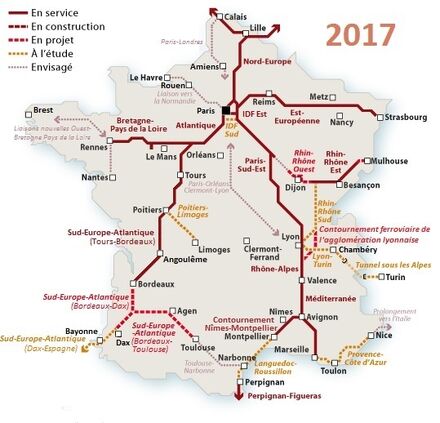
La Grande Vitesse Pour La Grande Nation
What's especially apparent about the French system is how it expands into neighboring countries. Bigger ones have their own lively domestic systems, others got colonized by neighboring systems. Domestic demand alone would've allowed the western and Mediterranean routes to be built, but the rest has been helped by destinations in neighboring countries. Nord-Europe was the second LGV to be built, but its name alone already says that it's so much more about London, Brussels, Amsterdam and Cologne than merely Lille. The Chunnel is largely to thank for HS2 to even be considered in Britain. LGV Est-Européene has likewise become a beacon into Germany before getting a proper extension to Strasbourg.
LGV Rhin-Rhône has little to with a love for Alsace and a lot to do with linking up to Switzerland and Germany. Currently, the routes hardly mesh and the first tangential LGV in eastern France will primarily provide quicker direct connections from Germany to the Med. Even LGV Atlantique ended in Le Mans and Tours for over 20 years before its extension to Rennes and Bordeaux just this year. If those routes ever mesh for big tangential routes way beyond Paris to become a reality, they'll first have to branch out enough that filling the gaps becomes less of a drag. In this decade, the SNCF is in the process of introducing clockface scheduling for the TGV. The idea is that e.g. trains from/to either Paris or northeastern France to/from either Marseille or Montpellier will stop in Lyon at the same time and offer a convenient interchange. When in doubt, this goes at the expense of Paris because TGV terminate at and depart from Paris all the time anyway.
One Country, Multiple Centers - The InterCityExpress
When the HGV Nürnberg-Erfurt goes online by the end of this year, the internal unity of Germany has also been achieved in its HSR network. Berlin to Munich will shrink from 6 to 4 hours. It took more than ten years to build and some critical voices wanted the project to be shelved. Then again, the very first HSR line Hannover-Würzburg in Germany took 18 years to build and what both lines have in common is their shared difficult topography with many tunnels going through the Central German Uplands. Those connections don't sound as sexy as Cologne-Frankfurt or Hamburg-Berlin, but that's the thing: They're trunk lines connecting general directions in a polycentric Germany. The maiden line followed the logic of a divided Germany, yet it took a connection to West Berlin into account. The newest line will properly fit east-central Germany into the all-German grid. In essence, you see a role-model network that works into all directions. Then again, this has been achieved with more than just new dedicated HSR lines. The blue lines on the small map indicate upgraded legacy lines and they're plentiful in the north with its flat topography. Often they're not longer as they have to be because it suffices to work out under the auspices of the clockface schedule.
Priorities Matter Most - The Fast Grid In Switzerland
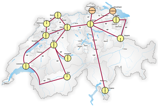
Due to its special political system, Switzerland needed plebiscite-proof legislation for upgrading its grid. The clockface schedule is actually a brainchild of the Swiss people in order to serve the stations beyond the big cities with just as fast connections. Even foreign HSR trains follow the clock inside Switzerland. On the other hand, especially as it's a small country with proximate interests just beyond the border, Switzerland is also active in lobbying and also financing HSR beyond its borders when it's rather in the interest of Switzerland than of the lines' host countries. This is especially true for the LGV Rhin-Rhône which ends in Mulhouse which is just around the corner from Basel. Another potential target would be a line to Munich that would link up to Sankt Gallen. High-speed rail inside Switzerland is only then built when it makes node-to-node connections shrink under well-defined thresholds, usually multiples of half an hour. Orange clockfaces indicate a 15/45 nodes instead of 00/30 as they need to be accessed in multiples of quarter hours. Image #1 shows the state as of 2000, image #2 its expansion after the opening of the Lötschberg Base Tunnel, image #3 after upgrading lines in direction Germany, and image #4 shows the desired state of 2030 well after the recent opening of the Gotthard Base Tunnel which is about much more than just that.
Other European-Country-Sized Examples
Check out this 50-page port from the Midwest HSR Association where they explain how Spain has trains that combine diesel and electric engines and two types of gauges to offer comprehensive HSR services besides the usual AVE trains, let alone the differentiated local, medium and express services of the Japanese Shinkansen.
United States Is Like Several European Countries
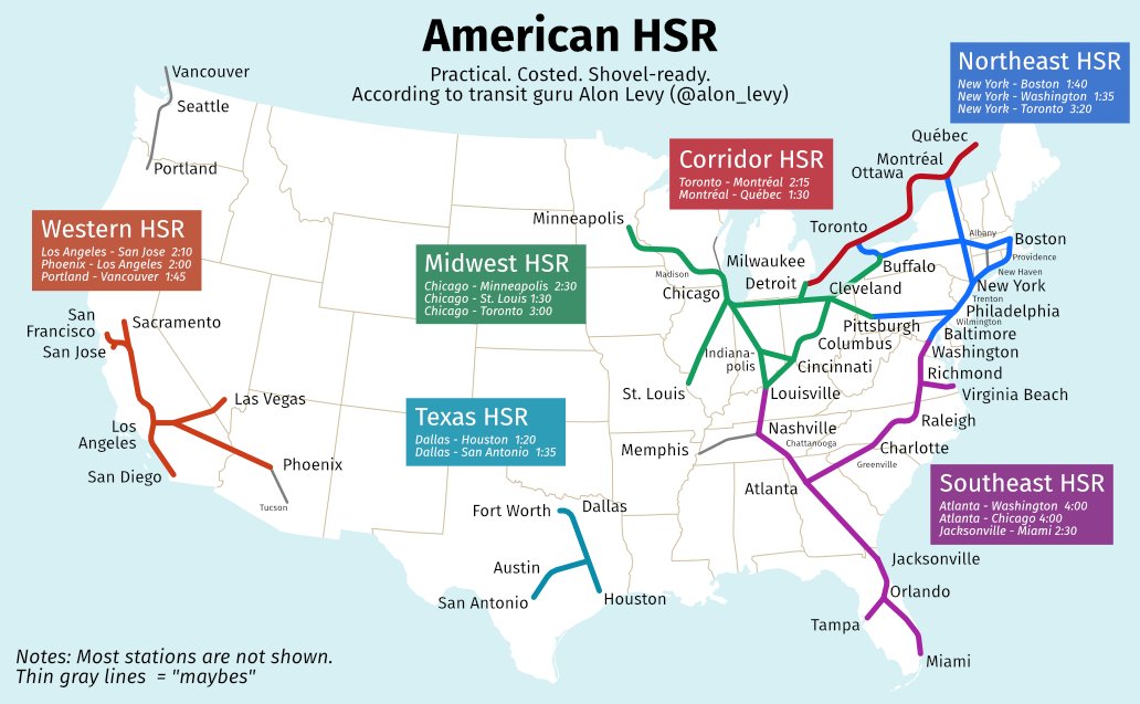
Distances are insane in North America, same for Australia. And unlike China and India, there is no equalable density of population to indiscriminately criss-cross the entire place with HSR. Then again, there are some megaregions that could be best describes as a comprehensive set of agglomorations, a landscape of cities if you want. And if you look at those megaregions, you see some striking similarities. The Great Lakes form a hub-and-spoke system not unlike France where Chicago serves the central role akin to Paris. The maiden trunk line connecting northern and southern Germany equals the Fresno-Bakersfield part of California HSR and if look that the Rhine, you see something like a corridor as in BosWash, Piedmont Atlantic or the I-35. The biggest megalopolis in the world however is the Blue Banana stretching from England via the Rhine down to northern Italy, like Manchester to Milan if you want.
I am loving this thread. Hey, if I made a metro map, would you be willing to give me some feedback on it? I'll include the real geographic distribution as well for reference.
Die Hard In A Metric System - Customary Units And Other Atavisms
If you're a good housewive, you need great mental math in order to try out new recipes or just to adjust odd numbers of meals. If you employ a drug lab, doing your math makes the difference between life and death for your customers. If you're an expat living in an English-speaking country, mental math becomes an insane affair. When I drove from Dover to Thurrock Lakesaide in July in order to maybe fetch AH.commer Marius from South Africa, driving the motorway on the left side with actual mileage was surprisingly easy. Not just the speed limits, every ten miles makes for 16 km and binary is easy. Even exits are noted in fractions of mile, a 1/4 mile is like 400 metres and a 2/3 mile is like 1 km. Then again, I'd been practicing hard for over twenty years for just that moment. I didn't drive the bus from Heathrow to Oxford in February, however.
As I grew up in my maternal grandparents' house with my father being deadbeat, old schoolbooks from their own two children were scattered in hidden corners of our (now my) house and my uncle had an English-German dictionary from middle school from Langenscheidt. Even before PONS, Langenscheidt is the #1 German dictionary brand, known by its blue letter L on a yellow ground. There will be extra pages for stuff like cardinal and ordinal numbers and especially weights and measurements. And as it's been a dictionary for English, you get the impression that mastering English also requires an insane amount of mental math. And I didn't even have an idea about money sums in £sd that have been thankfully dropped long before I've been born and even that dictionary was printed in favor of a decimalized currency.
I didn't care about drams and stuff, the differences between fluid and avoirdupois were insane enough (Thande had a rant about this ages ago and I replied as well.). I knew enough to know that 7 ounces equal either 200 grams or 200 mL. I knew that 1 lb equaled 453 grams and that a pint equaled 568 mL. I remembered that 1 lb = 16 oz., yet only noticed later when Starbucks came into town that its Venti size which is 20 oz. actually equaled a pint after all. I hate ounces, but I love a pint at any time! Small = 12 oz., Tall = 16 oz., Venti = 20 oz.; that's all easy to understand. Then again, I drank better latte elsewhere and Latte Macchiato is a disease in Germany. To do even quicker mental math, I realized how adding 10% to 1 lb turned 453 grams to 498 grams and I turned this in to a (metrified) pound = 1.1 lbs or 1 kg = 2.2 lbs. Much later, but long after I knew that US and Imperial gallons, tons and hundredweights were different, I was able to calculate miles per (US) gallon into litres per 100 kilometres. If you factor miles/gallon with litres/100 km, you get a number around 235. When I read that only vehicles over 13 litres/100 km qualify for Obama's cash-for-clunkers scheme, it was clear to me that American learned it as vehicles doing less than 18 miles per gallon.
Metrication in Germany went hand in hand with unification. All those little Germanies had different ounces and inches and inter-German trade needed a common yardstick. The German Customs Union defined a so-called Customs Pound per 500 g, they metrified the pound this way. They also defined a likewise hundredweight (Zentner) which was, you guessed it, 100 Pfund = 50 kg. Proper metrication was introduced in the years before unification and finalized early into the German Empire that also replaced the Customs Union.
Metric Won't Save You From Surprises
Metric is also decimal. OK, areas are rather square decimal and rooms and weights are rather cubic decimal, but there are offenders to this rule. Where shall I start?
The hectolitre (1 hL = 100 L)
If you need to count barrels of beverages, here you go.
Deka for your hamrolls (1 dag = 10 g)
Some places in Central Europe had so-called half-ounces or "loads" (German: Lot) and among them was Austria-Hungary. Depending on the ounce to be halved, a load could be anything from 14 to 18 grams. When metrication took hold in the Habsburg lands, people began to understand their Lot to be of 10 grams and called it a Deka. All successor nations of Austria-Hungary employ the Deka in their daily life and its mainstay is of course the produce counter.
The dutch ounce (1 ons = 100 g)
The old Dutch ounce was like 31 grams and metrication happened under Napoleon. For whatever reason, the Dutch generously rounded their ounce up for metrication.
The "decare" has many names and won't fit in (1 daa = 0,1 ha = 10 a = 1000 m²)
As someone with fields in the countryside, I know about ares and hectares quite intimately.
One are (1 a) is like 100 m² (10 m * 10 m), one hectare (1 ha) is like 100 a is like 10,000 m² (100 m * 100 m). That 100 ha equal 1 km² is clear as well but only of peripheral interest. Yeah, the Vatican is 44 ha big.
Then there's been the Byzantine super-acre called stremma that turned into the Turkish dunam and got employed under various names all over the Ottoman Empire and its successors, though it's been metrified before the Ottoman collapse to 1000 m² which places it between are and hectare. That's why can and also do call it a decare. Before metrication, any Dunam could be between 700 m² and 2500 m². Legally such a Dunam was the square of forty paces, but how much a pace was differed locally.
The word "ton" for a megagram(me) that's never been called that way.
All the costumary tons that may have existed were heavy enough in their twenty hundredweights that the word "ton" made it into the metric system for 1000 kg.
Metric Hundredweights If They're Used
Can you imagine that two Germans can disagree on how much a Zentner is? This can happen if one is from the West and one is from the East. Most Romance-speaking and former East Block nations adopted a metric hundredweight (called quintal in French, abbreviated as q) à 100 kg. So I chatted up with an older pal in the East via Skype and talked about stuff and asked me if I knew how much a Zentner is. As he's been socialized into the GDR and the East Block, we talked about the same thing whereas I from the West meant 50 kg and he meant 100 kg. If things need to be weighed and sold by hundredweights, let's say cement, you can offically call it 100 kg a Doppelzentner (dz) or, if your especially anal-retentive as said Eastern won't accept, a Dezitonne (dt). Then it's metric, it's unambiguous and nobody disagrees. Of course, various auxillary units which were somehow metric or semi-metric but had less ambiguous alternatives nearby were often expired by the end of the 1970s. Metric hundredweights perplex more than hey help, calories became joules and kiloponds became newtons.
I have a friend who's been working as a junior professor at the University of Michigan for three years. He'll pack up back to Germany with his new family. I asked him if he found it bothersome that Chicago is too far to drive and too close to fly. He said that he actually planned to take the train to Chicago, but found it more easy to drive after all and that it's OK. AH.com meetup culture is a Saturday morning to evening affair in a big city with most of its attendees hauling from the local area. The partial exception is the UK where people take a one- or two-hour trip with the railway to their desired destination. My own German meetup culture is a Friday night to Sunday morning affair, even though I'm an exception with my six-or-more-hour rides with the car. It's an extended weekend I take. If it was just one day at a pub, I wouldn't do it. Flying to London for a meetup is also an extended week I take, but I'm used to it. A math and physics geek that later turned teacher said that driving from Augsburg to Munich would be possible, but so stressful that he wouldn't play home music in Munich with his friends there and taking the ICE and relaxing makes the difference. I guess the UK exception speaks for itself. If there were HSR between Chicago and Detroit cutting down the journey to mere 2 hours, a Detroit AH.com member may well attend a Saturday-only meetup in Chicago. In reality, he doesn't and taking an extended weekend may conflict with his work schedule.
Ever since 2004, I've attended eleven annual meetups inside Germany and with the exception of the very first meetup near Frankfurt, they all ended up due north and I'm from the south and were definitely too far to drive and too close too fly. Yet there were only four occassions when I took the ICE, the German bullet train, and adjacent railway and LRT for the trips. 2008 was due to my car falling apart and not taking chances, the trips in 2010-12 got me to places with good public transport and being a nightmare for car parkers. The trips in 2015 and 2016 would've made great examples to take the ICE to get beyond Hamburg, but writing a BA thesis and grieving for my mother made long hours of driving really therapeutic, and the year after saw me buying a new car and driving away to the meetup for nine hours including one hour of detour to fetch a friend. I slept so little up there that I booked a night in Magdeburg after dropping off my friend out there and watched the World Cup finals in the hotel room. This was definitely too far to drive, but it was worth it. My friend hadn't been on a meetup for eight years at that time.
There have been plenty of discussions at this board about how to implement HSR in the USA and I needn't recapitulate what's been said there. So let's get to the basics.
Legacy Railways And High-Speed Rail Are Two Different Beasts
It used to be a matter of course that Salt Lake City got direct access to the first transcontinental railway in the United States. It followed a more or less straight line from New York City via Chicago to San Francisco and the Salt Lake area was of course the most populous spots in the Rocky Mountains thanks to Mormon settlement. Only later would air conditioning and the Hoover Dam shift the focus in the Rockies down south. And of course, railway used to be the only access out there before cars and aircraft offered alternatives. High-speed rail competes with said modes of transport, however, and therefore needs just the right amount of customers at just the right distance from one another. Therefore one can safely say that an initial continuous HSR link between Los Angeles and Denver would rather go via Albuquerque than via Salt Lake City. That's because Ft. Collins to Albuquerque can work out quite nicely, let alone LA to Las Vegas with the possible extension to Phoenix. Californian HSR can easily extend to Reno, NV near Lake Tahoe. But what about the rest inbetween?
Too Far To Drive, Too Close Too Fly - What Does This Mean?
This will especially mean a distance where an HSR would instantly kill the entire demand for aircraft connections at that relation. If you type in this catchphrase, you'll land at the blog from a Houstonian who takes a trip from Houston to San Antonio as a typical borderline case. This means something like 300 km where the advantages and drawbacks of driving and flying level each other. From my native hometown, this would equal the distance to both Cologne and Munich with Mannheim being a good approximation as it's an ICE node in similar equidistance. Another Houstonian at this board, @Big Tex , once drew up a concept and said he could easily imagine taking the bullet train to as far New Orleans or Oklahoma City. This would somehow equal the distances I drove for my German meetups.
Divide And Rule - Grow Several Tumors To Metastase
Edit from March 24th, 2021: I guess that's as clean as you can get. This was new from Twitter and better than anything before.
There won't be a transcontinental HSR, but there may one day be a transcontinental grid of HSR which may allow for bi-coastal journeys in under 24 hours if another 9/11 or super-blizzard were to happen over the US. There could well be a train course running from Chicago to Atlanta and vice versa every day because the train has to go where it's not in the way. But in the beginning, regional clusters will have to be formed before any "luxuries" may be meshed. California, Texas and Florida show here that they could theoretically exist as distinct nation states on the international scene. The Northeast and Midwest are comparably organic landscapes to exist on their own and the largely agrarian nature of what used to be called the Deep South manifests itself in the fact that the conurbations that the shown Southeastern network is supposed to constitute hardly constitute part of the Deep South. Atlanta is an urban hellhole inside Dixie and Florida has long stopped being part of the Deep South ever since retirees from the North flocked into it in masses. New Orleans is Deep South, but most HSR ideas call for a link to Houston.
From an Atlantan perspective, a link to Birmingham, Alabama is more prudent than a link to Chattanooga, Tennessee even though the latter is a more vital asset in direction Chicago. A link from Atlanta to Macon, Georgia may come quickly, but Jacksonville will first be linked with the rest of Florida long before anything up north. New Orleans will for long remain an eastern terminus for a course from direction Houston even after Oklahoma City (and therefore Texas) will have linked up with Kansas City (and therefore Chicago) until there will finally be a connection to Atlanta. Connecting Atlanta step by step up to Raleigh, North Carolina will be easy as cake compared to through-routing with Washington DC.
I didn't go all the way through it yet, but I have to say it's quite relevant transit map guide.
Thanks for sharing!
________________________________
Dumitru logistics
@VT45 I just tried to summarize what plenty of predecessors have already contributed in Chat and elsewhere in the last several years. It's also just a rough guide if you want to create something yourself with a sensible degree of verisimilitude. Drawing something up is one thing, but getting political majorites to succeed with proposals like that are also to consider.
On another plane, I've been thinking about a lot of things on what to write next. Retrofitting legacy dwellings for 21st century needs? The effects of taxation (why lakefront property is often narrow) and landlord-tenancy legislation (fat cats won't go away and profit most from rent control because units are still few) on urban landscapes? Street grids as a city's DNA? Plain old modes of transport and what it all entails? There are a lot of things to consider, but I'll start small again.
Retrofitting (Part I-1) - Let's Talk About The LRT At My Doorstep
Like so many other cities in Germany, my own hometown got razed at the end of the war by British bombers. We used to have an intact continuous historic centre that's been lost forever, not unlike Frankfurt. Then again, we used the opportunity of the disaster to force wider streets and lower density onto our old town. We also got rid of the tramway in the 1950s. By the 1970s, our historic theater in the north and indoor pool in the south of our major boulevard (former east end of old town) got demolished in order to streamline said boulevard into our central north-south axis, sporting four underpasses along the way from north to south: Berlin Square/Theatre (still existing, also accessing a car park), Harmony Civic Centre (bus interchange west/north), the adjacent Boulevard Underpass with commerce where the boulevard and Emperor Street cross and at Post (bus interchange west/south, regional bus hub at the former indoor pool in walking distance). This was a clearly automotive city.
In 2000, however, the Boulevard Underpass was torn down and filled for building tram tracks on its surface that the Emperor Street already got two years prior and a provisional terminus right there was opened a year later. My own home in the rich east of town got its access in 2004 and through-routing in direction east came at the end of 2005. Harmony and Post underpasses were quickly closed and filled as well and the whole boulevard got walkable crossings again. By the early 2010s, the east-west line was supplemented by a northern connection. Through-routing? Yes, Heilbronn has been "colonized" by the tram-train system from Karlsruhe. The renaissance of streetcars has many mothers and fathers, but Karlsruhe is a poster child and role model because it managed to take underused electrified railway tracks and build a hybrid train that runs on both streetcar and mainline railway voltage.
In the 1950s and 60s, Karlsruhe conducted studies that showed that the congestion to be combatted by shutting the tram would be even worse with busses. So they already skipped the abolition and started to streamline the whole system so that automotive and tram traffic was as separated as possible and doable. From the 1950s to the 1980s, the whole system grew not unlike the Manchester Metrolink where disused rail tracks got streetcar electrification. This was a solution in directions north, west and south, but not east. There's been an equally underused (though not dead) mainline railway with standard 15 kilovolt electification run by the DB, the Kraichgaubahn, mostly for freight traffic. So the AVG, the Karlsruhe transit authority, decided to have the cake and eat it too and built a hybrid train car which we'd call a tram-train nowadays. The first tram-train from Bretten to Karlsruhe went online in 1992. Passenger numbers exploded to an extent that the system became a victim to its own success. The most burdened inner-city lines of Karlsuhe will go underground from 2020 on. NIMBY protests were the reason why this didn't happen 10 years earlier.
Think of the Kraichgau as a green heart of a "randstad" between the motorways A5, A6, A8 and A81 in northern Baden-Württemberg. Karlsruhe is where the A5 and A8 cross whereas Heilbronn is where the A6 and A81 cross and said railway just pierces through the green heart. The towns of Bretten and Eppingen get served along the way, they're a bit off the motorways which are known to be jammed every day at rush hour. This is great potential for a train that takes you to the heart of a big city and not just a train station. The other crossing from Mannheim to Stuttgart gets served by an ICE bullet train connection. By 1999, this tram-train terminated at Heilbronn Central Railway Station and by changing to new tram tracks later, this turned into a true interurban service. There's actually a morning express train fetching you at about 8.30 am and dropping at 9.40 am at the southern campus of the Karlsruhe Institute Of Technology, formerly the TU before merging with the now northern campus. So yeah, if you struggle to pay your rent, like mommy's food or both, that's a great way to attend the 10am lectures and avoid killing (or getting killed by) a roommate you never had. My version was taking the S4 from home to Eppingen and changing to the S5 and disembarking at Heidelberg Old Town as it's in the east of town and I come from due east anyway.
Retrofitting (Part I-2) - Not Working Down There? Put It To Use!
Back in the days, where I live in eastern Heilbronn used to be nothing more than a hill, the Lerchenberg or Lark Hill and its development started with certain public institutions. Its biggest defining feature is the Main Cemetery which set up shop first here around 1880. Right after 1900, a one-track railway tunnel was built under Lark Hill in order to access the industrial south side of Heilbronn with the rest of the railways. The northeastern mouth of the tunnel made the track straddle at the eastern edge of the cemetery, further northeast downhill was a sickbay from the 1890s that turned into the municipal hostpital after World War II. Today's city park at the opposite side of the hill was also built right after 1900. So there already was some life near my vicinity before World War I, but not a liveable neighborhood. Even further east, the early Wehrmacht built the Ludendorff Barracks that also became a target during World War II. It became a DP camp after the war before becoming a base for American armed forces. So the site of my grandpa's future family home was wedged between the cemetery and a train track in the west, a hospital in the north and barracks in the uphill east. There is an old house begging to be demolished in a back street behind me dating from 1938 (I read my real estate agents) and the grid must have stood by then, but it was largely empty before my wedged-in neighborhood was erected largely in the 1950s and 60s. There's also the fun fact that the rear part of my street also made for the hospital's uphill frontier. My mother used to have problems hearing ambulances at some distance and wondered why all the drivers made way before she noticed the ambulance behind her because she generously overheard the constant tatütata behind her very own home.
So the years went by and things started to change. The east end hospital was closed in 1989 and the birth clinics became the main hospital. The Cold War was over, the Americans left and barracks turned into neighborhoods and industrial parks. South Station was closed due to insufficient demand and the Knorr works (instant food tycoon, now part of Unilever) as its last holdout was forced to use trucks for its products. As the overhead wire for the city park's LRT station needed room, the railway bridge between the Lark Hill tunnel and the rest of the network was knocked down and crossing the track from my home to the cemetery was clearly safe. The Badener Hof, formerly barracks, became a nature-proximate neighborhood and makes for a handy new start and finsh loop for bus line 11. The former hospital became an extension of my neighborhood and features a nursery home at the opposite of the LRT station. And as we're already at it, I also tell you that my former elemetary school was built on the grounds of another fromer barracks razed in the 1950s together with the city's revenue service and police department. The former South Station that used to feature a gas station with car wash and a Turkish produce market has been revitalized as a 21st century neighborhood with only the supermarket in its very west surviving. A stop sign in my neighbood was downgraded to give right of way because the train tracks crossing the street after leaving the southwestern mouth of the tunnel are no longer in use. But here's the thing: What happens with the tunnel?
Last year, a society has been registered whose aim is to put the Lark Hill tunnel into good use, specifically for pedestrian, cyclists and skaters. Here you have flat tunnel under a hardly accessible hill and connecting the parks in the east with those at the central south at the Neckar river makes for a great benefit, especially as former South Station features bike lanes ending in the east for the moment that can't stay that way forever. I have a personal interest in this connection. I live at the northeastern mouth and the southwestern mouth is in walkable distance to registered doctors and my GP, a nursery home, a bistro-bakery, a stationery shop (elementary school nearby), a bakery and a butchery attached, an ATM and a street letter box. This tunnel should be used, but there won't be any streetcars running through even if the suburbs at the disused line that this tunnel has been indirectly been built for should have a LRT one day. They will however need to find a new course through the city's south side. Deal with it.
Topografic map of my hometown and environs from 1902 in 8K You see that the Lark Hill underpassed by the tunnel was yet wineyards, the bends of the 200 metre contour line in the north-northeast of the wineyeards roughly follow the future path of my street. You also see the nucleus of Röntgen Street (of X-ray fame, No. 9 was built in 1938 and finds no buyer) and Mandry Street which was just produce back in the days. Most of the streets to be built here later were named after doctors and scientists.
Retrofitting (Part I-3) - Dude, Where's My Fibre?
Internet access is a disaster in some parts of what we call the First World. I'm lucky living a city environment where there's ubiquitous 50 Mbit/s over the traditional phone line, though hardly more. Cable TV also costs just 20 quid per month which is cheap compared to America and if I wanted, I could get even faster internet over my cable provider. Our physical cable was laid in the earliest 1990s, so it's good and fresh enough to go and one tenant even used it for internet access. LTE can be an alternative where the wires are weak but mobile radio is strong. The "final solution" to the data problem would be true fibre to the home, however. And yes, here you can get fibre internet access by the local utility provider, but not everywhere. Look at that drop-down menu with the word "Wohnort" (residence) where you can see where their service is available and you'll see that they don't categorize first and foremost by municipal borders, but rather by projects. Some "residences" are indeed whole villages, small towns and neighborhoods and they've been accessed because traditional internet connections are abysmal out there and people got together to make the city works do what Deutsche Telekom won't do. All addresses can and will be served out there for just this purpose. Then there are redeveloping projects that are yet under construction or recently finished. There you'll find just a few streets where ZEAG offers you true fibre to the home. Those are a former plot of horticultural greenhouses wedged between railtrack dams and the modern LRT station near my home (Jägerhausstraße), the Southern City Yards I mentioned (Happelstraße) and the future docklands neighborhood to open after Garden Show 2019.
EDIT: I outsourced some pictures to this post as you can only have 10 at a time and I didn't want to spam. The first image shows the maiden grid of my neighborhood right before World War II, the streets initially christened after military brass and as such instrumentalized by the Nazis for propaganda reasons. Yes, also Lettow-Vorbeck, you fanboys at AH.com. They were quickly renamed after the war, mine after a July 20th complicit, most after famous physicians, Ludendorff Street became Einstein Street. The other two show U.S. Army barracks near the end of the Cold War and how the rest of the city has matured to grow into them to some degree.
NIGHTMARE TENANTS - SLUM LANDLORDS: THE ORDINARY MADNESS OF LANDLORD-TENANCY LAW
(I found the Channel 5 show of the same name by chance. I use an ASUS router working as a VPN client and pretend to be Swiss to use the Zattoo app with its Swiss catalogue for free, featuring most stations of all neighboring countries (with Swiss commercial breaks, but still) and surprisingly from the UK as well. All BBC England and ITV channels, 4 and 5 and much more. I could watch the World Cup like a Brit if i wanted. Not in HD, but I don't pay for that.)
I'll start with an article from The Economist where they talk about the German "rent brake" and how France and maybe a Corbynite Britian may want to emulate it and how a constraint enacted for innermost Paris was struck by courts for not applying to the whole agglomeration and making rent hikes just move from the innermost city to the adjacent ring. So what makes a good landlord-tenancy law? Taking the German example that applies to a country that traditionally had more tenants than homeowners since after the war and seeing the differences, I conclude this:
"A satisfying and sustainable landlord-tenancy law is such a law under which, on the one hand, tenants don't feel the need to become homeowners quickly and at all costs just to preempt rent hikes (property prices can also hike, mind you) and strange effects of landlords' caprice and, on the other hand, landlords still feel an incentive to sustain and offer tenaments to rent out."
This, of course, means that landlords need very special reasons to evict a tenant they don't like. Legacy tenants should count on rent hikes to not become that high that they can't afford their neighborhood anymore whereas newcomers don't have a right to complain about how expensive a neighborhood is that they're about to move into. Then again, you should be able to evict healthy people with no dependants on board that fail to pay their rent with relative ease as a landlord and you should be able to raise the rent from time to time to a reasonable level and not be afraid of somebody occupying your tenament for 10 or 20 years just because you cannot adjust the rent to inflation or general economic development. Good laws are balanced laws and the courts just rule the details.
Property Taxes And Architecture
Do you know why houses in the historic center of Amsterdam are so narrow? It's because they used to be taxed by their width to the street and it's been assumed that your stake at the central streets determines your visibility and therefore demand as a business and therefore income; they also feature sets of pullies to move stuff and furniture through the windows that wouldn't go through the narrow staircase. That's also why lakefront property at e.g. the Mississippi River arose from parcels defined by the size of the river bordering it, the actual size of the hinterland be damned. Then again, you know "How The States Got Their Shape" and why most states east of the Mississippi just had to border a river or a lake or an ocean. My house has been built in the 1950s in one of the best neighborhoods in town. My property taxes however are insanely low and that's due to a detail in Germany's law governing property taxes. The taxes should in theory depend on property prices, but due to laziness or whatever, it's been the prices from 1965 (West) and 1934 (East, the GDR knew no market values for property) that have been grandfathered for tax evaluation. This provision has been struck by German courts due to violating the equal treatment clause in the Grundgesetz. Grandpa took a mortgage of 10,000 Deutschmarks from the Sparkasse if I read the cadastre right and the blueprints say that building the house itself equaled 40,000 Deutschmarks of cost. Today's property without the house would easily cost 400,000 euros. If they reform the system to accounts for 50 years of value hikes, it will get a bit unpleasant for me.
Besides this, you also see other differences among jurisdictions. Anglo-Saxon nations have a bigger share of homeowners even among working-class people and property taxes are usually true to their value. A vulnerable poor homeowner may therefore choose to sell his house easily and set up shop where it's cheaper. Here in Germany, we used so-called unity values based on the imaginary unit "Mark 1914" to estimate the value of a place for insurance fee purposes. This system is supposed to absorb shocks of volatile price developments and it's supposed that the eve of World War I was the last time when property prices weren't volatile. This is very complicated to calculate and I just leave it to that.
Rent Ceilings As A Form Of Slow Expropriation
The UK and Spain used to have tight rent ceilings that made creating tenaments very unattractive unless it was very simple one-room units to rent out to swagmen. That's also why council houses became a staple in British culture and it's also been a rent ceiling that made way for the famous Gemeindebauten in Vienna, the mother of all modern council houses. Total mobilization for World War I urged the Cisleithanian government to enact a rent ceiling and an eviction ban as soldiers and their now out-of-home-working wives would struggle to make ends meet and may fail to pay their rent. The ban wasn't lifted right after the war, so the new Austrian state of Vienna, created by 1922 by dividing Lower Austria into christ-social Lower Austria (Rural) and social-democrat Vienna, found itself with cheap plots to be bought that private developers didn't want because rents for frozen. Said Gemeindebauten were also built by levying a property tax with the most expensive 1% contributing to more than half the revenue, dropping rents for needy tenants from about 30 percent of their income to maybe 5 percent. There was also a rent ceiling in West Berlin which meant that a lot of building lacked indoor toilets that could be taken for granted anywhere else.
And let's not forget East Germany: It was hard to have more than one private home in Socialism, but if you happened to be able to rent out a dwelling in East Germany, you had to put up with rents frozen at 1938 levels and a Reichsmark equaling a GDR mark and all this meant that your property became more of a burden than actual value. And if had your own datcha or stuff, it was often that the dis-entitled landowner was still legally the owner of the plot whereas the house on it wasn't. Rights of use were therefore of more real value than hypothetical land titles and if you put your sweat and tears into such a project, you didn't want to lose it, especially not to the child or granchild of a "old-owner" who would've otherwise forgotten about the plot if not for the fall of the Berlin Wall. You can imagine how complex the rules for reprivatization of expropriated lands and real estate became in Reunited Germany. It was restitution with exceptions, especially for the datchas built in the meantime. If Korea was ever to be reunited, it's only fair to grant ownership to the actual occupants as they have nothing else. Furthermore, a consequent compensation-over-restitution scheme would be very investment-friendy as the descendants of disentitled old-owners would simply be cashed out from the all-Korean budget and no hassle for new investors in the North.
I've been to the city archive yesterday because I wanted to see what's already been there before the war and what came after as I guessed that my street must be little bit older than the execution of the guy remember by the street's name. And so it is.
Some overcounting pictures have been retrofitted into the post about retrofitting. The interface of the phone camera must've switched directions when I shot a closeup of my immediate street neighborhood and picture seems hardwired to stand up 90 degrees to the right at least at this board. They didn't have anything from the 1970s.
So here we are and what used to be a sickbay around 1900 became an orphanage by the mid-1920s and beyond the railway tunnels was hardly anything. Gardens and wineyards, but that's it. Ten years later however, the orphanage gave way to a new sickbay (later city hospital), the Wehrmacht built barracks, an entire road to access it has been built and also some streets inbetween for a new neighborhood were under construction. What was true for one mouth of the tunnel was also true for the other one, the environs were in development. The arteries of the modern southeastern edges of town were already operative, but streets are one thing, life is yet another. The so-called Outer Lark Hill was therefore framed, but yet undeveloped. Twenty years ater that, my grandparents married and moved into the yet quite empty Tub Valley and the grid in the Outer Lark Hill as the (now second-)highest spot of continuous urban settlement largely stood. The now highest spot in settlement, the Sand Hill, had yet to be accessed and only was in the 1960s, now the spider-shaped Nuremberg Street which features my former kindergarten and now polling station. An analogous process happend north of the city park and the main cemetery found its final modern size in the same decade. What looks like the longitudinal section of a womb and vagina down the western edge of the Southeast map is Herbert Hoover Street and Settlement. Yes, this was a military neighborhood with its own American school just opposite to the Southern Barracks, now the Swabian Yards. The American school became an elementary school with some middle school classes, there's a Kaufland supermarket nearby as well as a much smaller Russian store and a Greek restaurant at the opposite side of the street. Whatever significantly changed since the 1988 maps (see the Retrofitting post) can be seen on Google Maps, Bing Maps or wherever.
Retrofitting (Part II-1) - European Terminals Get Their Open Heart Surgery
Belgrade, Republic of Serbia, 30th June 2018:
The old main terminal of Belgrade (Beograd-Glavna) at the right bank of the Save River before it enters the Danube River will be closed after this night. Beograd Centar, nicknamed Prokop by locals, will take over most of its remaining functions in the morning of July 1st and the rest will be dispersed among other terminals, like Topcidar which will take over the car train to the Adriatic Sea in Montenegro. What yet has to be finished at Beograd Center is supposed to become so by the end of the decade. Did I mention that construction started in 1977?
Belgrade is Europe's biggest railway development hell to be recently finished if you count by the time since the start of construction. The breakup of Yugoslavia and the adjacent political instability in Serbia are largely to blame for this. Then again, it's also a poster child for many other metropolitan transit projects because it's the closest thing to an actual clusterfuck of epic proportions and is therefore especially symptomatic for many perceived and actual problems other projects elsewhere face as well.
So What Is It All About?
Belgrade has a delicate geography and topography that suits poorly to major reconstruction projects that overtaxes the economic prowess of a Balkan state that nonetheless is forced to function due to its strategic location even if it's too much to ask. Belgrade and environs is where the flat Pannonian Basin in the north and the Dinarian Mountains in the south meet. Clockwise from the south, Old Belgrade south of the Save and Danube Rivers is very hilly and makes for the only part that belonged to the Kingdom of Serbia. New Belgrade near Zemun in the west between the Save and Danube Rivers is flatland which allow ed for an easy expansion of Belgrade after the Vojvodina became part of Yugoslavia. The part north of the Danube ain't part of Belgrade proper and makes for the southern end of the Vojvodina.
Beograd Glavna was an extension from (Budapest-)Zenum via Novi Beograd and a Save railway bridge. Beograd Dunav makes an extension from (Romania/Banat-)Pancevo via the same-named bridge. Accessing Beograd with its northwestern and northeastern neighbors was a political quagmire before World War I, so to speak and the railway is a symptom for local 19th century geopolitics and therefore a prime alternate history target. If you look at Old Belgrade, you see some small valleys among the hills:
Belgrade Waterfront at the shore of the Save River as it will be called after Beograd Glavna will be demolished.
Prokop, a valley to the southeast of the Waterfront that quickly ends in a cul-de-sac. This is where Beograd Centar has been built.
Topcider, due southwest and the valley that accessed Glavna with the rest of Serbia and the south in general.
In a nutshell, the new Save railway bridge goes straight northwest-southeast from Novi Beograd into the Prokop valley. Two tunnels had to be pierced through the hills in order to access Prokop beyond the cul-de-sac: Dedinje tunnel into the south and Vracar tunnel into the northeast. This through-routing scheme allowed for Beovoz or BG:voz to have become a real crossrail scheme for 20 years before mainline railways finally ditched Glavna for Centar. This is because the times have become so modern that piercing tunnels through the hills is actually way easier and cheaper than building the stations within.
Belgrade Ain't Alone With Shenanigans
PRAGUE
Just as Belgrade has a fully reformed railway node but no proper rapid transit, Prague is quite the opposite. Accessing Praha hl. n. from the north has always been a drag, so Masarykova had to take the burden even if it's considered out of repair and cumbersome enough that there's talk of giving it up entirely. Suffice to say, Prague's railway node has to make up for lost time and needs some serious additional capacity. The first step has been done from 1999 to 2007 with the construction of the New Connection, a big viaduct and a set of new tunnels replacing older ones to make for a comfortable access of northern lines to Praha hl. n. The opening of the New Connection coincided with the introduction of the commuter rail system Esko. Many northern lines have both a branch ending at Masarykova and a branch to Praha hl. n. Yet this does little to improve capacities at Praha hl. n. which is supposed to not be able to overtake the burden from Masarykova. The best way to replace an old commuter rail terminal that somehow stands in the way is replacing it with a tunnel and Prague has also come to its senses.
You know how Liverpool Street Station on the Elizabeth Line will also access Moorgate as it's so big?
Prague Opera will similarly straddle between Main Station and Museum and got a new name to express this.
This is usually called the New Connection II and involves a double crossrail connecting Bubny and Karlin in the north with Smichov and NBS (Vrsovice) in the south. The distance between the two southern mouths and the knowledge from Munich that every crossrail will become a victim of its own success as they'll build a second one parallel to the first one with fewer stops made the Czechs avoid taking chances. What I'm missing here is a stop at Albertov that I've seen in earlier drafts between Opera and NBS to access Charles University and the many tram lines in the valley between I. P. Pavlova and Vysehrad, especially how NBS lies on the way to Hostivar and that place features a big student dormitory. You see how the tunnels are supposed to bypass the overground bottlenecks and take all the outer arteries with them. If this is finished, they can raze Masarykova for good. You also see how every metro line finds an interchange to this scheme. And if you read my early chapters, you know that I'd definitely recommend the Czechs to choose the crossing scheme and not the tangential scheme. People expect a line to connect opposite ends.
Commonalities with Belgrade:
The whole node is considered to be a mess to be fixed.
The central terminal is a necessary evil to be overcome and alternatively developed.
Tunnels to be built are the way to overcome the central terminal.
Differences to Belgrade:
There is no new central railway station to be built. Praha hl. n. already was a run-through railway station.
The central terminal is to be replaced with the crossrail tunnels instead of a new station even if the Belgrade tunnels also have crossrail functions. This is however similar to the fate of Potsdam Station in Berlin after the opening of the North-South tunnel, it was just the suburban sister to Anhalt Station.
Belgrad had the new railway station and crossrail stations in mind when planning its future metro system. Prague has to take its existing metro network into consideration when planning its crossrails.
The question of through-routing intercity passenger traffic is separate from urban-suburban crossrail solutions.
VIENNA
The Austrian capital's bid to consolidate intercity travel in one through-running station got new fuel when the fall of the Iron Curtain relieved it from its artificial borderland situation and brought it back to the center of Europe. Northwest Station is a cargo terminal whereas North Station was demolished and the closest thing to a successor is Wien Praterstern, a station where the Northern Main Line and the Connection Line unite to form Vienna's crossrail. Actual intercity traffic from Northern Main Line has ever since used an eastern bypass to arrive at the eastern terminal of South Station.
South Station was actually two termini with a united station building, the eastern section that housed the Eastern Main Line (and the Northern via said bypass) and the western section that housed the Southern Main Line. Both rail lines make for the edges of the 10th borough of Vienna, called Favoriten being the most populous borough of Vienna and arose as a typical working-class district. So it was easy to see that South Station developed into the natural site for a future consolidated central railway station for Vienna.
Then there's been West Station which housed the Western Main Line and was the natural end point of most intercity connections as Vienna is the easternmost German-speaking city since 1945/50 and of course the easternmost city of Danubian Austria. Said Western Main Line didn't have a powerful connection to South Station as the Southern Main Line had via Wien Meidling. This was a problem to be addressed for creating a central railway station.
Why leave that many words when you can see for yourself?
So the earliest 21st century saw the construction of the new railway station at the site of the diagonally situated freight yard of South Station that already connect the Southern and Eastern lines as desired. The only tunnel to be built was the Lainzer Tunnel under the wildlife reserve park in westernmost Vienna that made for a direct connection of the Western Main Line to Wien Meidling and therefore to the new Vienna Main Station. Similar to Beograd Centar, Wien Hauptbahnhof was opened in phases, starting in 2012 and completed by 2014. One regional benefit of through-routing is the fact that Vienna Airport in the eastern suburb of Schwechat can feature direct railway connections beyond central Vienna.
West Station hasn't been closed, however; it's rather turned into the major regional rail hub for Lower Austria where Vienna lies in its very east. Property development has been done nonetheless to compensate for the loss of passengers and adjacent local demand for business. As the old South Station was a bit off from the new main station, they're actually one crossrail station apart and places changed names with subsequent development. The site of former South Station is now called "Quartier Belvedere" with its S-Bahn station consequently renamed and the new main station was built upon Southern Tyrol Square which already had an S-Bahn station also. The old name is still shown in brackets next to the designation "Wien Hauptbahnhof".
Commonalities with Belgrade:
The consolidation of railway services into one new railway station.
The whole project was a ramification of a changed political geography.
Differences to Belgrade:
Beograd-Glavna already was a consolidated central railway station, only its cul-de-sac nature was a problem.
Vienna West Station wasn't razed for property development which happened anyway.
Three out of four directions were already accessible, only due west needed a new tunnel.
The site of Vienna Main Station has already been used for railway purposes and wasn't exactly new, just a bit off of South Station. Prokop was a cul-de-sac by nature and was the best way to handle an awkward situation due to its awkward nature.
BERLIN
Berlin's central railway station was opened in due time for the World Cup in Germany 2006. The idea dated back to World War I when the city yet had several termini that this station was to replace. Those termini were closed in the early 1950s, the divided city had factual main stations at Zoo (West) and Lichtenberg (East). Berlin was a broken shell of itself after the end of the Iron Curtain and this offered an opportunity to fix things from scratch because there wasn't exactly a running system to disturb.
The site of Lehrter Bahnhof where the future Berlin Hauptbahnhof was built was not far from the later Reichstag and especially a jail which became the JVA Moabit and was considered to be in the middle of nowhere even by contemporaries of the 19th century. Yet it was smack dab in the middle of the city of Berlin. The east-west overground crossrail "Stadtbahn" opened in 1882 was built to ease transfer between termini, so it comes to no surprise that Lehrter Bahnhof was adjacent to it also. This also eased the idea to build a double-decker station to replace them all.
No, they weren't on drugs. That's really called the Mushroom Concept.
So the 1990s and early 2000s saw the construction of some north-south running underground arteries under the Tiergarten near the Reichstag: A stretch of subway called U55, a road tunnel to rebuild the B96 in Berlin and a railway tunnel to complement the Stadtbahn at the site of the future central railway station. It's grand opening came together with other new intercity station at the way such as the northern Gesundbrunnen and the Southern Cross both crossing the Ciricle Line. East Station was retained, but not Zoo Station which is still used regionally and by private intercity providers. Zoo Station already had a grown accessibility that the new station lacked. It's also speculated that forcing people to transfer away from Zoo Station was a way to promote business for the leaseholding shops inside the new central station. Accessing Berlin Hauptbahnhof is cumbersome. Closing the U5 gap will take until 2020, the tramway has been extended at the station's footsteps, the second north-south crossrail only recently saw the start of its construction. On the other hand, the construction site of the station itself bothered nobody as it was in nobody's way. So?
Commonalities with Belgrade:
The whole project was a ramification of a changed political geography and it changed a lot of times in Berlin's 20th century.
Most intercity trains terminate beyond Berlin Hauptbahnhof and therefore access bigger parts of the city directly, though the location depends on where they come from. In Belgrade, the two intercity stations Novi Beograd and Beograd Centar (Prokop) on both sides of the Save River make for a systematic tandem.
Prokop is also "a bit off the heartbeat" despite its nominally central location. It's got a reputation as a celebrity neighborhood with all the hills around the valley. Unlike the Berlin station, Prokop has the potential to turn the place into a vibrant South Side of Belgrade. And of course, the development hell of a railway station didn't bother anybody in both cities. This would've been different if Berlin's new main station would've been built at e.g. Berlin Friedrichstraße. On the other hand, local public transport needs to catch up in both examples.
Berlin has an iconic underground mainline railway station besides the usual intercity station. Potsdamer Platz has a cube-shaped entry hall that hides a regional rail stop at the north-south link that also serves Berlin Hauptbahnhof besides accessing the S-Bahn. Preparations for a phantom U-Bahn line (U10/U3) were also done when tearing apart Potsdamer Platz whereas the legacy U-Bahn (U2) has to do without "cube" access. Belgrade has Vukov Spomenik in the northeast of Old Belgrade that works as the infrastructural brain of the Beovoz or BG:voz network and was built with cathedral-style Soviet metro stations in mind.
Differences to Belgrade:
Reunited Berlin could build upon legacy structures that just went dormant for half a century for geopolitical reasons to create a better version of its former grid. In Yugoslavia, it's taken almost half a century of active planning and construction while actively surviving new geopolitical obstacles to overcome a dysfunctional network conceived by even older geopolitical legacy issues.
Hugely popular Berlin Zoo Station has been downgraded from an intercity station to a regional rail station by German Railways after Berlin Hauptbahnhof went online. Call it leading the horse to the water, this was quite unpopular. Prokop may be the only station to be served by every train serving Belgrade, but Novi Beograd works as the factual transit hub of Belgrade and giving up its intercity station status entirely would be logistical nightmare.
LEIPZIG
The east-central German metropole has built a north-south crossrail under Central Station and what used to be Bavarian Station. There are five stations at the trunk line: Main Station, Market Square, W. L. Square, Bavarian Station and MDR. Main Station is long enough to fit in a bullet train and has the option to be enlargered to a maximum of 800 meters. It's usually a crossrail which can double as a simple intercity station if need arises.
The development hell lastet from 1913 to 2013. The initial idea was having a small underground rail under the eastern ring between Main and Bavarian station via August Square. World War I halted construction and World War II prevented a continuation, some bombs fell into the tunnel, killed people and tore it into three pieces, one of them used as a cinema in the GDR and now demolished. 1946 plans called for two tunnels, the much later realised crossrail and an intercity tunnel for Berlin-Munich journey that was cancelled due to the Cold War. Construction happened 2003-2013 with Western money and stayed under budget with €935m instead of €960m.
Commonalities with Belgrade:
It's an extreme example of making up for lost time.
Differences with Belgrade:
The realized scheme is an almost humble iteration of initially bigger plans. Well, at least you could run an ICE train underground through Leipzig if need really arose.
STUTTGART
Oh yeah, Stuttgart. My beloved state capital. I remember how I started a thread about it. In a nutshell, somebody came up with the idea to construct a bullet train line along the A8 motorway between Ulm and Stuttgart. This evolved into Stutgart 21 which is currently under construction: Replacing the cul-de-sac terminal with an underground east-west through-running main station that will also need further tunnels to go online and will also feature an ICE station for the airport and the fairground. Removing the legacy terminal tracks allows for recreating walkable greenfields and the construction of mixed-income housing which is why Stuttgart 21 also features a northern extension of the city's crossrail with a new stop called Midnight Street. The new underground railway station needs room from a legacy LRT tunnel, so an ersatz tunnel has to be built before the old one gets torn apart. Similar ideas for Frankfurt and Munich have been shelved indefinitely.
Commonalities with Belgrade:
Two big tunnels are built to access a new railway station.
The inner city of Stuttgart is also situated in a climatically unauspicious valley-hill site just like Beograd Prokop. When it gets warm, it gets really warm and fresh air becomes a problem. There have also been riotous "Parkschützer" (park protectors) that demonstrated against chopping trees in the city park to make way for the reformed railway station. There's a very old bypass railway in the northeastern borough of Bad Cannstatt which is actually older than the proper city of Stuttgart. Night trains from Karlsruhe to Munich will drop you at the suburbs of Ludwigsburg and Plochingen, but not Stuttgart proper.
Differences with Belgrade:
The new railway station is also underground in contrast to Prokop.
Stuttgart had only one intercity station to begin with and the site of the new one will be the same.
Bricks And Clicks - Dark Stores Are Pretty Harmless
This is actually a thing I planned some time ago and when Kaufland announced its very first dark store in Berlin, I was excited and thrilled to see how it would pan out and when a dark store by Kaufland would finally deliver to my house. Unfortunately, it's been closed this year and Lidl & Schwarz ceased its online operations entirely for the moment and that's because they tried to underprice EDEKA with its Bringmeister (translates as fetch-master, serving Berlin and Munich at the moment) service in their supply chain and failed. REWE still does online delivery, but never had a dark store and just made employees pack the cart for the orders in the regular stores. This is great as your own market penetration with regular stores makes a broad geographical base for your service. On the other hand, if I see how small my next REWE store is which is already 1 km away from me between "our" church and Planned Parenthood and how their next medium-sized supermarket is at the other end of town, I tend to think that dark stores become inevitable in the long run as I see employees tripping over regular customers. When it comes to online groceries, Germany is still pretty much a developing country unlike the UK where over 5% of all grocery purchases are subject to online delivery orders and this will likely have grown in the meantime. 5% is also the approximate long-term share of vinyls in music sales after its revival in the age of streaming. The biggest novelty in grocery technology here in Germany is Aldi wanting to build multi-story tenament buildings upon new stores on fields it possesses in big cities where the housing market has become just as dire as in other Western countries. And some ARAL petrol stations offer REWE to go, meaning that you can do some very basic grocery shopping deep in the night even if Sunday rests are a constitutional sacred cow in Germany.
Similarities between a dark store and an IKEA
Kaufland's initial dark store for Berlin used to be in the southern neighborhood of Lichterfelde, still in Berlin and not far from Brandenburg either, home to the first electric streetcar in the world and served by the S-Bahn lines 2 and 25. This parallels nicely to the London borough of Croydon which houses the first dotcom store of Tesco, it's also down south and so peripheral that Tramlink became a reality out there whereas the Cross River Tram for central London was instantly killed by Boris Johnson taking over London. If you look at the sites of London IKEA stores, you see there are stores in Croydon, Wembley, Tottenham and Thurrock Lakeside, serving all cardinal directions of London while being way out of the inner city. Berlin has its IKEA stores in Spandau, Tempelhof, Lichtenberg and near the BER airport. Tesco's dotcom stores show a similar geography: Croydon is clear, Greenford is near Wembley, Enfield is near Tottenham, yet Erith is well inside the M25 unlike Thurrock Lakeside. And of course, dark stores #2 in Aylesford, Kent and #5 in Crawley, West Sussex serve more of the adjacent home counties.
The key to both dark stores and furniture stores is accessibility. Furniture shopping is an event for many people, the IKEA effect has been a name long before Apple introduced closed ecosystems for tech companies as a thing to do, and people are ready to drive one hour to visit such a venue. Of course, groceries are the polar opposite and only come into play here because the stores go the reverse route and drive to your home. Yet there are comparable logistics issues. In both cases, the centralized stationary business model relies on short ways to a big number of costumers which are ideally found in agglomerations. This also means that traffic jams are the biggest turnoff in vendor-costumer relations which means you'll rather find these venues in the suburbs, most ideally at the motorways. The problem is actually more acute with grocery delivery than with furniture. People need their daily stuff every day and all the time, you need to be steady and reliable every day for a more regular clientele.
A sensible threshold for a dark store?
A lot of thinking about the evolution of dark stores can be read in an article at Canadian Grocers Dotcom which also shows a theoretical evolution from purely retail store based pickup delivery to the employment of a CFC, a so-called centralized fulfillment center that exclusively feeds the dark stores separately from the classical distribution centers that feed the walkable retail stores. Adding up which Canadian cities were suitable for dark/dotcom stores, they reference to cities with 1 million denizens per minimum. Asda in the UK has dark stores in Leeds and Nottingham, the latter with just 300,000 people in its city limits. I guess that any conurbation with 500,000 inhabitants at the least should successfully sustain a dark store by every grocery chain in the land. Hardware stores are yet another matter. Such a thing should always grow organically and just as you can divide supermarkets into hypermarkets, supermarkets and discount stores, online delivery can go multiple ways and its perfectly fine for a Tesco Superstore in Great Yarmouth to double as a dark store (or make one in Norwich do the job) whereas such a thing would be insane for a big city. And the bigger the city, the more private parking becomes a problem and you'll just need somebody to carry your stuff to the fourth or fifth flour and therefore online delivery.
Summary by Canadian Grocers Dotcom - Three Degrees Of Organization
Type I - Retail Store Pickup Delivery
Workers risk tripping over customers and stockage may see gaps to be filled, but you'll achieve unpredecented presence over the land due to your already existing locations.
Type II - Dark Stores Treated As Any Other Store
This is the intermediate step giving the most normal feel. There are dedicated dark stores to cater online demand and leave the walkable stores unaffected. Yet they still share the same distribution centers on the land whose role is just to restock any store anyway and whereas the dark stores equally lack the presence of their costumers, they're made for easy pickup for deliveries which distribution centers aren't. So you still have the desired division of labour between walkable and non-walkable stores whereas the general logistics stay the same. But you can take everything to the next level and that's why Tesco decided to introduce Type III. In general, the more concentrated online delivery, the less walkables and non-walkables of the same chain compete for stocking.
Type III - Centralized Fulfillment Centres (CFC)
These are dedicated distribution centres that exclusively bother with the dark stores in the land and specialize even further away from the needs of walkable stores. The fact that Tesco employs two CFCs in the London and Home Counties area speaks for itself. You cannot have a CFC at the expense of a classical distribution center, but only in addition. You need to be present in the area, but you also need a sufficiently accessible demand to sustain such a division of labour.
Imagining London Underground in Max Sinister's Chaos TL for my fanfiction Samowar In Atlantis (aka MY BIGGEST FAILURE)
If you read my infamous Samowar In Atlantis fanfic based on the Chaos TL, you may have read how I imagined 2000 London Olympic Games after the 1996 Fort Knox ones. Well, this was supposed to be a trailer for another chapter that I failed to conceive. I wanted to reimagine the London Underground along the lines of Socialist path dependies and combining this stuff with technological prowess that IOTL is yet to come in the 21st century. I imagined how London in Socialist Britain would've had a very Soviet-style metro system, like being deep underground to work out as a nuclear fallout shelter and having that triangular interchange layout for maximum efficiency in its inception. I also thought about incorporating an idea that IOTL came from a Catalonian student in the late 2000s: An escalator where three stair steps could be leveled to one for a wheelchair on demand. There were a lot of problems that made me give up on all that.
First of all, I realized that London had the ideal soil for digging tunnels and that the core network in OTL, though private ventures followed for-profit logic that a Socialist system wouldn't abide to, would've become pretty much the same as in any timeline. Second, even a cash-starved Socialist Britain would've head its underground before instant sunshine was invented, so there wouldn't have been any concentrated efforts to dig extra-deep fallout-proof underground tunnels from scratch.
Third, London would still be so big that there isn't just one center to build an interchange triangle around. The City of London would've been dethroned for Socialism, is the House of Tomorrow supposed to be in Islington which IOTL belongs to the earliest studied examples of gentrification, a proud worker neighbourhood turning yuppie? Why not the Docklands? And why should the German Logo (hacker) Topper return to London after the Streich? Just for exposition to show how pushing a button makes a London Underground escalator a disabled-friendly transport? Who's he supposed to show? Björn is bound with MBA studies in Atlantis and going to the Chiemsee for a total eclipse and having Natascha's piece of ass once more is enough of a distraction from his studies. But two weeks for Olympic Games in England? And how far would he come with his German? They know French and Italian better than German.
Fourth, even without the Catalonian concept of push-the-button-ADA-accessible escalator, the Londonist on Youtube showed e.g. how a so-called inclinator makes a great 45-degree lift and is perfect for retrofitting existing stairways for wheelchair-accessibility. And as I found, the Prague Metro station Strašnická (opened 1987 in Communist Czechoslovakia) also features a relatively low-tech open-cabin inclinator of some sort at one point. I realized that I couldn't create a cold-war-punk version of London Underground for everybody after the Streich to show just for the hell of it. It's like extreme graphics are supposed to be the future, but they aren't. Damn. And so I quit.
Features of typical big European post-Communist cities
1. Poverty is the best conservator: Streetcars/tramways
In the West, it's like every family could afford a car. Not so in the East and the underperforming economy in Socialism with the subsequently slim public coffers also meant you couldn't do everything your Western counterparts did as well, even if so desired. That's the major reason why virtually all towns and cities that already had tram tracks retained them in East Germany [1] whereas the rest of the East Block retained them in the bigger cities at least. The construction binges in the West were way too costly for the East and the limited private wealth also meant that streetcars were the most economic way to access new quarters. There was already a network to start with, steel wheels are more robust than tires and electricity is the secondary form of energy that could be converted from anything. Just like high-speed rail works out most at distances "too far to drive, too close to fly", tramways work best at that sweet spot of capacities where busses get inefficient and rapid transit yet isn't worth it. Retaining the streetcars also eased the biggest drawback of Soviet-style metros: Long ways between the surface and underground with the escalator and longer distances between the stations.
[1] Being the definite battlefont in World War III where everything with rubber tires moves to the front does this to you.
2. Explaining the logic behind the Soviet triangle
This is a question somebody asked at skyscrapercity.com and which took me to that board in the first place. The most comprehensive answer was this: Most new quarters were new high-rise buildings at the edges of the city which produced the necessary numbers of passengers along the desired routes in the first place. The triangle is little more than an improved hub-and-spoke system that unweaves the jam of interchanging passengers from the start. Two metro lines make for one interchange, three lines handily make for three interchanges, yet four will already make for six and things will start to get complicated. It's a great system to copy and paste into lots of untouched cities that need to build their systems from scratch.
Triangles have also been employed outside of the former Second World. The modern iterations of the Athens and Rome systems come into mind and the simplistic design for effectively piercing the inner city for the best effect is especially attractive if a city has millennia of archeological history under it soil. Munich downgraded from originally four planned lines to three triangular lines with bifurcations (U1 to U6) and also features additional servcies that connect trunk lines to outer stretches of alien trunk lines (U7, U8) and a new trunk line, the U9 bypass, has been planned to connect the outer edges of U3 and U6 directly with Main Station.
3. What to keep in mind for your alternate timelines
If you want to design a subway system for communist cities in an ATL, imagine the history of the city before the regime change and how it may have plausibly evolved. Don't plaster the whole place with Soviet triangles, especially if a legacy of a pre-Communist system is entirely plausible and even probable. Geography will always remain the #1 obstacle to any urban planning under any ideological auspicses. Virtually every interchange contour and especially the Soviet triangles got placed at one bank of the its major river where its traditional center sits (Kharkiv in Ukraine has two of its three lines end in the triangle, mind you). Communism in Sweden won't change the geography of Stockholm as a city of islands where stacking two tubes over one another at the same strait made the most sense. Especially the Nordic social democracies with their small populations have rather small capital cities under 1 million denizens and have rather streamlined metro systems. The closest thing to an inner city ring or triangle in Stockholm was created at the northernmost shore with the most continuous hinterland. Oslo converted its stub-end western and eastern tramway and suburban rail systems into metro systems before converging them into one trunk line that eventually turned into a circle line. Copenhagen was fine with its S-tog for the entire 20th century and only the construction of Ørestad made it create a yet nascent-feeling network. Helsinki has similar shore issues as Stockholm and has one east-west line trespassing various waters.
Living Off The Substance: The OTL Case of Former East Berlin
A good example for a city inheriting a legacy network into the forces of real socialism or equally ideologically motivated inefficiency would be OTL East Berlin where a very grown rapid transit system was cut in half and the traditional center was at the edge and like the handle of a fan. Unlike all other European satellite states whose capitals only started building systems in the Cold War (I also count in Budapest in here because its original Földalatti hardly meshes with its modern sisters) and therefore had to make up for a lot of lost time, the East Berlin network grew very slowly. Most new rapid transit lines were S-Bahn lines where an extra set of double track was laid next to the existing legacy railway line and got third rail electrification and the sites of the new satellite cities were purposefully placed along those railways. It also helped extremely that an outer railway ring had already been in place to circumvent West Berlin and legacy railways in direction east were often abandoned as their intended destinations now belonged to Poland. Even line E, the modern U5, only saw a one-stop underground extension to Tierpark after which it directly runs overground as line E served as an ersatz trunk line where the east-west trunk line would've been overburdened. Said outer railway ring was also supposed to get additional S-Bahn tracks as a makeshift solution to expand capacity without building a prohibitively expensive inner-city tunnel, but then the Cold War was over and the ghost lines under Berlin-Mitte became accessible again. The makeshift solution hasn't been completely forgotten by modern Berlin however and the city is growing richer and more populous again.
Likewise the ends of lines C and D in West Berlin (and transiting through East Berlin borough of Mitte) needed a proper connection to City West around Zoologischer Garten and Kurfürstendamm (Ku'damm for short) to create a consolidated large-profile U-Bahn network on West Berlin territory independent from the East. This was done by creating the north-south-running U9 completely from scratch and creating the east-west-running U7 out of the southeastern Neukölln branch of line C. The full extent of line U7 ran suspiciously in parallel to major S-Bahn lines (run by the GDR in West Berlin also and boycotted due to the Berlin Wall), so were the northern U8 extensions and also a line U10 whose construction was cancelled after the handover of the Western S-Bahn to West Berln constituted a frustration of its mere purpose.
Case Study: The Quasi-Mirror Europe of the Chaos TL
A good case study would be, once again, Max Sinister's Chaos Timeline whose ATL communist/socialist countries don't show any geographical congruence with the OTL Second World. The British Isles turned red in the 1840s and Max Sinister followed original Marxist theory that the most developed country would have to become the first communist country as well and therefore London would've had to become the very first constructor of rapid transit worldwide and still pay dearly for adopting and especially developing the model for everyone else. And London is so big and has such a perfect soil for underground construction that you cannot just plaster a Soviet triangle onto it. A city like Rome that would've been the capital of the New Roman Empire would've surely built an own rapid transit system in the 50 to 100 years before Italy turned red, though it still inherits the problem of its ancient soil full of archeological gems.
Paris could've had a system in place before World War I because the Emperors were so generous *irony.exe off* and technology is decades more advanced than IOTL, but I guess it's more difficult in Iberia where local kings were fighting for dominance after the end of the New Roman Empire before getting swallowed by the Socialist Block. I can imagine them being a bit like OTL Budapest, with some legacy lines accompagnied with modern cookie-cutter triangles. And who says that Socalist Iberia in the Chaos TL would only see subways in Lisbon, Madrid and Barcelona? Note that the OTL systems in Madrid and Barcelona were already inaugurated in 1919 and 1924 respectively and appear quite massive whereas Lisbon had to wait until 1959. Greece as a backwater ITTL as well as IOTL with its archeological richness could've fared quite similar to OTL. The Northern European systems with the possible exception of Hamburg would've been quite young by comparison and they've also been built only after World War II IOTL. It might be tempting to plaster them with triangles, but their general proximity to the sea (city center at the shore, high ground water levels) and their rather low populations gave way to some peculiarities IOTL and this won't change ITTL. The biggest obstacle may actually be re-envisioning how the street grids look like, especially the further in the past the POD is. In this world we live in, London had some notable fires in the Early Modern Age and Old Paris was leveled around 1850 to make way for the modern street grid designed by Baron Haussmann.
And OTL shows that there's still variation among the Central and Eastern European countries. The two lines of Sofia Metro are actually one physical rail corridor reminiscent of an HIV awareness bow split in the middle of the loop and the third line is yet to be built. Bucharest Metro started out as a circle lines (M1) that the straight east-west line M2 descended from. Line M3 crosses line M2 classically whereas M4 only touches the circle M1. Only a line M5 may one day form the perfect Soviet triangle. Prague Metro was the only textbook example of a triangle to be completed during the Cold War. Budapest in disregard of its millennium subway is also a perfect triangle that may one day even take it to the next level like Saint Peterburg. Warsaw Metro started with plans for only two lines to begin with. East of the Vistula, line M2 shall get a bifurcation that shall one day grow into a Line 3 that shall also grow back into left-bank Warsaw, crossing M1 at a new Constitutional Square station between far-spaced Centrum (M1/M2) and Politechnika (M1) stations. This would be a very elongated triangle and bears no resemblance to classical Soviet designs.
OTL Moscow could draw from experience of established systems to avoid many mistakes. War booties from Berlin U-Bahn could easily run in the Moscow system with minor conversions (750 V DC in Berlin, 825 V DC in the Soviet Union) because it's been modeled after the Berlin system. Its platforms are built to prevent One Unders from the start and for good. It also debuted the triangular system with Teatralna station having three levels at two corners at the short edge inbetween.
From East to West: Welcome To Modern Berlin
The formerly divided city still features two hearts beating in its chest. 40 years of divergence in urban planning won't just vanish over night. Until LEDs will have replaced them all, the differences in street lights in former West and East Berlin will make the two former halves look distinct enough in the night from space. There's also public transit coming to mind.
West Berlin was especially distinct as Western money from the FRG allowed it to tear down its tramway network and generously expand the U-Bahn network, especially vis-à-vis the (Eastern-run) S-Bahn that's been boycotted since the construction of the Berlin Wall. U9 and U7 were built and extended to create a consolidated network inside West Berlin that made other extensions only viable in the first place. The northern stub of U8 was extended to access Märkisches Viertel projects in blissful ignorance of the existing S-Bahn and the earlier U6 extensions were masterminded long before division.
East Berlin couldn't axe the tramway in the same way (it got away from Friedrichstraße and Alexanderplatz, however) and even expanded it to access new high-rise housing projects, often building them in proximity to existing railways that provided an easy way to turn it into an S-Bahn line (Ahrensfelde, Wartenberg). Hellersdorf would've overburned the S-Bahn system which resulted in the overground expansion of the otherwise underground line E (now U5) beyond the Outer Berlin Railway Ring. The next projects to be built by 2000, if the GDR had survived, would've been in Malchow which is just beyond Ahrensfelde at the Outer Berlin Railway Ring.
By the time the Cold War ended, you had a West Berlin full of U-Bahn and BRT lines on the one hand and an East Berlin full of tramways on the other hand. There's a reason why two specific ghost stations along U8 were re-opened as border checkpoints: Jannowitzbrücke was easy to access by S-Bahn, but Rosenthaler Platz was easy to access by tramway. The U-Bahn was and is definitely the best way to get to West Berlin. And also to get out: When I attended a meetup in 2010 near Mehringdamm station (U6/U7) in Kreuzberg and lodged in a hostel in Mitte, it felt way more easy to take the tram from Oranienburg Street (S) to Oranienburg Gate (U) and directly get to Kreuzberg than going directly underground and change at Friedrichstraße.
Expanding the tramway into the West hardly happened. If you remember how the "party tram" M10 goes from, western but still east-proximate, Hauptbahnhof to Warschauer Straße in a half-circle, there's a strong case for extending it over the Spree River to Neukölln in former West Berlin at Hermannsplatz, U-Bahn interchange of U7 and U8 and former home of a cathedral-like Karstadt mall that the SS self-destructed in order to deny the incoming Red Army a food temple. Two subway lines cross here, but they won't cross the nearby river which requires an interchange at Kottbusser Tor to finally make landfall in Warschauer Straße which needn't be your final destination after all. An M10 extension would cut one or two interchanges in this relation and get you directly to e.g. Frankfurter Allee with its U5 which will likely never see an extension of U1 from Warschauer Straße to create an interchange, especially as an extension to Ostkreuz is preferable for multiple reasons.
That's the central southeast I've been talking about. Let's talk about the northwest instead. The extension from Hauptbahnhof to Turmstraße in planning is sometimes criticized to be a bad substitute for a more effective, but also more costly, U-Bahn extension beyond Hauptbahnhof to the U9 at Turmstraße. The promised land is actually even further northwest. Though Berlin won't like insular networks, Spandau makes a compelling case for just that. And once it's been built, you could organically mesh with the remainder of the Berlin network via Siemensstadt (where a dormant S-Bahn begs to be re-activated ever since Siemens announced to build a technological park in its birthplace) and what will become of Airport Tegel once it's been closed for BER. Stuff like Hermannsplatz and Turmstraße are just extensions to create checkpoints for the tramway in former West Berlin. Extending the M4 tramway in a southwestern fashion to mimick original U10 plans is charming, but stuff like the Spandau proposals are the only real deal for tram reconquista.
Features of typical big Western European cities
The capitalist cities in Western Europe did have the money for the complete automotive frenzy en vogue after the war. In order to showcase the differences between East and West, a specific example in the East comes in handy.
What if Leipzig had stayed a Western city?
The transit system would look decidedly different from today. The scarcities of Socialism limited the automotive frenzy with the separation of the driving public and the vulnerable road users. Limited, not prevented. If you look at this quintessential example of a medium-sized big city (5-600,000 denizens) that used to be a somewhat important city of the Reich (long tradition as an exhibition site or even Reichsmessestadt, most important fair of the GDR in East-West relations, kickstarted the Monday Demonstrations against the Honecker regime), you may take a guess how similar cities in Western Europe would've developed under Socialism.
Post-transformation Friedrich Engels Square (now Richard Wagner Square), northwestern Inner City Ring of Leipzig in 1973 from a pedestrian perspective
Same place from an automotive perspective
Overground is always cheaper than underground. It's no miracle that Communists generously plastered cities with high-level pedestrian bridges and often also viaducts for highways as it's been easy to construct. The shown pedestrian bridge in Leipzig was actually demolished in the early 21st century. Examples for viaduct highways whose destruction was discussed but rejected for the moment are in neighboring Halle (an der Saale) and in Prague as the North-South Connection, former West German Ludwigshafen on the other hand decided to demolish its "high street" for a tunnel instead. Typically Eastern however is how the classic streetcar network stayed classic and especially entirely overground and this is true for the entire Second World. Similar cities in West Germany however turned their tramways into LRT networks with underground tunnels in the inner cities. They definitely feel like subway stations and have proper interchange levels.
Stuttgart has two big bi-level interchange stations at Charlotte Square and Main Station where the Valley Lines and Cross-Valley Lines meet. Cologne never had a master plan, it lacked a powerful north-south inner-city connection at the left bank of the Rhein River even before the war destroyed the streetcar network (now in underground construction and jerry-building paired with criminal energy led to the implosion of the Cologne City Archive) and its central railway station used to merely feature a stub of a streetcar line before automotive transformation.
It's not the only way to do it, but it's most examplary.
A completely different animal was Hannover, however. Hannover is like an echo to Leipzig, especially as the Cold War and Leipzig being in the Soviet zone and later the GDR meant that the biggest fairground in the world has been built in Hannover to make up for loss of Leipzig. It was also the home to the computer fair CEBIT before it's been cancelled after this year's fair. Here it's been even worse than in Stuttgart, best seen in the fact that the B tunnel straddles along parts of the A and C tunnels and there's one big-ass interchange station for all three tunnels at Kröpcke. Hannover is solid flat land unlike Stockholm, but congestions really was and is that bad. The D tunnel hasn't been materialized and would only serve two lines (10, 17) and the current Red-Green city council actually transforms the legacy overground D line to become ADA accessible at this moment and there's contentious debate how sensible the whole thing is.
Leipzig has a different urban geography with a track-free historic centre embedded inside a ring road where all tram lines converge. Removing tram tracks from big central plazas to turn them into big pedestrian zones has been done in both the East and the West, so it's safe to say that Leipzig Market Square without the auspisces of real socialism would've got rid of its streetcars just as quickly after the war and, as it's been realized in the 21st century IOTL, only got train access by the north-south crossrail that ITTL could've been built in the 1960s and 1970s just as in most important West German big cities. If you look back at the start of this thread, you'll find the colorful spaghetti bowl of Leipzig tramway. Each of those colors could've gotten its own ring road tunnel trunk line with a comparably beautiful mess of a scheme along its ring road as the existing one in Hannover IOTL. The tracks in the western part of the ring road could've suspiciously remained overground as it's just of peripheral congestion. This is, of course, a Wirtschaftswunder scenario for Leipzig. Post-material societies like the real present one prefer low-floor vehicles on a classical streetcar network.
The Billion People Nation Equivalent To The Soviet Triangle: Paired Cross-Platform Transfer
The proliferation of an institution comes with redesigns and other improvements that will hardly be retrofitted into pioneer systems. Moscow-descended systems are a poster child, of course, but there are other instances as well. Cross-platform interchange stations exist in numerous metro systems in order to ease transfer. The problem is that any platform can only handle half of all directions. It's usually clear that most people go for one rough direction at rush hour, but Chinese cities found it to be a missed opportunity in some cases not to offer this convenient way of interchange into all directions.
The biggest question is, of course, how you get people to leave the train at the right platform. The answer is that those are two separate stations. Then you can say leave for the other line here for direction X and skip this stop for the station right next in order to change for direction Y. The first adopter was the formerly British Crown colony Hongkong which designed Mong Kok and Prince Edward station in just that manner to allow for this elegant form of interchange into all direction. It shouldn't be a surprise that the second adopter of this design was the capital of Taiwan before Mainland China became the third adopter in Wuhan whose metro system is the umpteenth in the People's Republic.
In the upper right, we see how there's one "antagonistic" cross-platform interchange station for two classical directional ones. In this case, passengers that need to change in the inconvenient direction may decide if they want to walk upstairs and downstairs or if they want to change the train twice. Tourists wouldn't put up with this brain yoga, but regular commuters would have to.
I remember an illustration of the four tunnels that unweave the mess of Camden Town at the Northern Line in all four relations. One station has to be antagonistic as I said, so it's nice to see that they took the one-level one to be directional.
The thing is this: Only really populous countries have enough million-denizen cities to proliferate a role model like that and improve it, IOTL starting with the Soviet Union and continuing here with China and one day maybe with India. As this post at our urban planning and transit thread shows, path dependencies die hard at least inside a language community. That post also illustrates how the typical American street grid allowed for 4-track subways in New York City and how Paris left its inprint in Montreal.
The Answer To All Other Questions: Latin American BRT Systems
Several cities in Latin America and elsewhere employ a hierarchical busway system where express lines fit the role of tramways and subways in other cities. It's easier and cheaper to establish, especially if it's badly needed.
Curitiba has like ten different types of bus services whereas Bogota has like five. Curitiba had the luxury to be able to plan its growth before it came, the Bogota system streamlined a lot of formerly chaotic private relations. In a reverse situation to New York City where private minibus systems survived the end of a subway driver strike which created it in the first place (mostly ethnic), private minibusses still run in parallel to this public transit system. Those exemplary hierarchical systems tell you all about any public transit system in the world.
Hierarchy is indeed anything. There may be places where busses may suffice, but you can also have bendy buses and minibuses as further differentiation. You need trunk lines that satisfy the need for speed and capacity just as smaller modes of transport that ensure the accessibility of the entire community and this can come in many variations.
A BRT system shows that the city actually needs a prime urban rail system, but can't afford its realization. And it will definitely not constitute the entirety of a city's bus fleet. One example would be Berlin whose West used to raze its streetcar network: The M lines started out as double-decker bus lines (Metrobus) and the principle was later expanded to the tramway (Metrotram) and were specifically designed to serve relations where rapid transit is lacking but needed.
A designated LRT system is intended to be the backbone of a transit system. Therefore you'll have bigger gaps between stations to increase speed and capacity. The backbone of the Valley Lines in Stuttgart that bifurcates at many centrally located stations runs in parallel to the central crossrail of the S-Bahn with comparable distances between their most central stations and many bifurcations cross the crossrail at specific station you've got to remember. The Cross-Valley Lines don't just cross the Valley Lines at Charlotte Square, but also the crossrail and several LRT lines at Main Station. If I really need to get home via Main Station (instead of doing P+R in Stuttgart and environs), I sometimes ride out to Marienplatz (great record store nearby) to take the line 10 (a cog railway) to Degerloch because I know that all Cross-Valley Lines (save for a tangential line each in the north and south) cross the two designated stations I already mentioned.
A city with both a rapid transit system and a tramway network won't have anything inbetween. Vienna converted its age-old LRT system to fit into its nascent rapid transit system and both did and still do exist side by side to the classical tramway network. The citizens of Zurich canton rejected both an LRT system in the 1960s and a subway system in the 1970s. The crossrail system (S-Bahn) was however approved and makes for the backbones whereas the tramway provides for the ample dispersion inside the city.
Well, this was supposed to be a trailer for another chapter that I failed to conceive. I wanted to reimagine the London Underground along the lines of Socialist path dependies and combining this stuff with technological prowess that IOTL is yet to come in the 21st century. I imagined how London in Socialist Britain would've had a very Soviet-style metro system, like being deep underground to work out as a nuclear fallout shelter and having that triangular interchange layout for maximum efficiency in its inception.
I think your biggest mistake was falling for that stupid cliche that every "socialist country" in an ATL will be exact clone of OTL Eastern Bloc countries, apparently down to design of the metro systems (!), even if that makes no sense given the historical background. Or maybe that was Max's mistake, I dunno.
That's the major reason why virtually all towns and cities that already had tram tracks retained them. The construction binges in the West were way too costly for the East and the limited private wealth also meant that streetcars were the most economic way to access new quarters.
That was maybe true in Germany, but it didn't apply to all other countries.
For example in Poland, most tram systems were closed in 60's and 70', and it was for economical reasons - diesel fuel was cheap, so it was cheaper to replace smaller tram networks with buses than to maintain them.
Warsaw Metro started with plans for only two lines to begin with.
That's wrong. There were many plans for the Warsaw metro through the history, and only few of them featured only two lines. They were, chronologically:
1. The earliest plan from 1927 with three lines in layout that's kinda weird from the modern perspective.
2. Two later pre-war variants, one from tramway's directorate (in red, 7 lines), one from the city magistrate (in black).
3. The most interesting one from 1948 - technically not really a metro, but "city railway", designed to interoperate with regular railways:
This was a plan that was closest to be "two lines" - the third one is really a commuter railway, and the north-south line was to be trifurcated (!) in the middle.
4. "Stalinist" plan from 1953 with "classical Soviet triangle" in the city centre:
5. Three-line plan from 70's with a different triangular layout. Linked image isn't the original plan - at first, the green line was supposed to go to the north-east instead of the south-east. This plan was a basis for the modern system, and the north-south line was realised exactly as planned, but the plans for the rest of lines changed many times:
- The green line was shortened to West Station - Gocław section.
- Later, eastern section of the green line was transferred to the red line, and the north-eastern section of the red line was rerouted to Targówek and Bródno. Interchange point between red and green line was also moved to the vicinity of the National Stadium.
- Western section of the red line was rerouted to go not under the Wola Street (Wolska) but under the Górce Street (Górczewska).
- Red line was lenghtened by one station in the west.
- Finally, the plans for the green line and later, the south-eastern section of the red line were dumped.
I think your biggest mistake was falling for that stupid cliche that every "socialist country" in an ATL will be exact clone of OTL Eastern Bloc countries, apparently down to design of the metro systems (!), even if that makes no sense given the historical background. Or maybe that was Max's mistake, I dunno.
That was maybe true in Germany, but it didn't apply to all other countries.
For example in Poland, most tram systems were closed in 60's and 70', and it was for economical reasons - diesel fuel was cheap, so it was cheaper to replace smaller tram networks with buses than to maintain them.
That's wrong. There were many plans for the Warsaw metro through the history, and only few of them featured only two lines. They were, chronologically:
1. The earliest plan from 1927 with three lines in layout that's kinda weird from the modern perspective.
2. Two later pre-war variants, one from tramway's directorate (in red, 7 lines), one from the city magistrate (in black).
3. The most interesting one from 1948 - technically not really a metro, but "city railway", designed to interoperate with regular railways:
This was a plan that was closest to be "two lines" - the third one is really a commuter railway, and the north-south line was to be trifurcated (!) in the middle.
4. "Stalinist" plan from 1953 with "classical Soviet triangle" in the city centre:
5. Three-line plan from 70's with a different triangular layout. Linked image isn't the original plan - at first, the green line was supposed to go to the north-east instead of the south-east. This plan was a basis for the modern system, and the north-south line was realised exactly as planned, but the plans for the rest of lines changed many times:
- The green line was shortened to West Station - Gocław section.
- Later, eastern section of the green line was transferred to the red line, and the north-eastern section of the red line was rerouted to Targówek and Bródno. Interchange point between red and green line was also moved to the vicinity of the National Stadium.
- Western section of the red line was rerouted to go not under the Wola Street (Wolska) but under the Górce Street (Górczewska).
- Red line was lenghtened by one station in the west.
- Finally, the plans for the green line and later, the south-eastern section of the red line were dumped.
Max is not to blame. It was the plain old "rule of cool" formula. I remember my first visit to an Eastern-style system when I was 13 in 1999 which was before the flood of 2002. Now the tubes for the escalators at Namesti Republiky have become a nice light ivory-beige just like me car that's been recently wrecked, but back then it felt like midnight blue and I was in night vision mode just as usual. And when I showed somebody pictures of Petriny under construction, this evoked similar feelings again. Max's idea of Chaos TL socialism was "colorful socialism" as it spread organically and no nation could actually dominate the other.
Looking at urbanrail.net, it's indeed insane how many small cities in the GDR retained their trams. What's also true for Poland, however, is that the big cities retained their tramways instead of turning into an underground construction binge. GDR could be explained yet even worse: They subsidized the neverending crud of everything in order to "overtake the West without outrunning it" and that there was a price to pay for this. And this could've meant that switching to diesel busses was too costly if other endeavors were more important to keep up the regime with some kind of social contract. Before the Berlin Wall was constructed, the brain drain in direction west kept the GDR from growing, and after that, the GDR government had to somehow appease its population and priorities are priorities, so all the trams kept running.
I'm sorry that Warsaw only came to inaugurate its system so late, but I have to admit that the current network and how it's planned is much better than all those prior conceptions. They looked really awful. I wonder how the future interchange between M2 and M3 will look like from its inception. Bilevel or cross-platform interchange?
Retrofitting (Part II-2) - Upgrading and Consolidating: Utilities and Home Improvement
What hasn't already been put in there in the first place won't be installed for decades to come. That's rule number one for any builder out there. The best example for this rule is the fact that overhauling Westminster would cost an estimated £20bn, require eight years of construction and especially a provisional relocation of Parliament. And example of a now-running overhaul of Parliament is the Austrian one in Vienna. All functions have been evacuated, the process goes from 2017 to 2021 and the MPs conduct their business in the Redoute Wing of the Hofburg. Some things can't be done as a patchwork as the systems to be renewed or replaced run through the entire building.
The early 21st century has also seen the replacement of water supply lines that were 150 years old in some places, especially London. The individual plots that will need an overhaul once a generation after all are a completely different matter. Check your water pipes and electricity for that matter, HVAC is the most underestimated point. How do you watch TV or get into the Internet for that matter? The most elegant solution would be through a socket in your wall, but this cannot be taken for granted in every room. Powerline is a way to easily extend a local area network where other options aren't handy, but legacy circuits in general are rather underengineered for modern demands and I can speak from personal experience.
In 1995/96, we had a hedonist C2DE couple as tenants at our ground floor flat that would've easily fit in at a rave or sensation with a lovely black-white cat. They moved out after a year and left us with a broken bath tub plughole and broken electricity. They sued us for the deposit and lost. The circuits from the 1950s in the living rooms were definitely not designed for the high watt numbers that a strong bass just requires. Mom and I occupied opposing bedrooms in the attic and she asked me if I was to blame for the noise. No, they came from "those downstairs" as we refered to our tenants. It was Friday at 11pm and that's when the "Housefrau" show at VIVA aired in my own childhood room. I was in 4th grade, by the way and whereas I wouldn't have considered myself a techhead back in the days, there just wasn't anything better on air at that moment and my taste in music wasn't that far away from it: Classmates gave me the second studio album by Ace of Base as a present for my 10th birthday. Oh, what the irony. That's why electricity is way better at ground floor than in the rest of the house, the installations are a whopping 40 years younger and designed to be more resilient. And what used to be my grandparents' bedroom never got an antenna socket as it was intended to be used a bedroom and what hasn't already been put in there... you know.
Here we've got a prospect about a new housing project in my city which shows which stuff may be desirable nowadays and easy to implement if you build a house anew but will create headaches if you try to retrofit them. A plug to close off for your electric car to recharge at home, sure, that's the future. CAT 7 as the backbone for your local area network into every room of your house or apartment, sure. Homeplug adapters are the poster child of retrofitting solutions, but the less you need them, the better. Audiovisual fish eyes for your security? This goes way beyond Tool Time in the series universe of Home Improvement. They don't write if they've already got fibre to the home, I fear no, but they definitely should. And as an heir, I've also read that a fibre cable rather won't be built alone into a house, but more as one of 2x2 pipes: Electricity, water, natural gas and fibre. My front yard wouldn't survive an overhaul, that's for sure, because every floor will need an own garage. At least I'm in a city and my internet could be worse, which brings as to the next problem.
Internet access is a disaster in quite a few first-world countries and many people don't even know it. America is a poster child in this regard, sure, but my native Germany also has its moments. I live in a city where you've got 50 Mbit/s for download and 10 Mbit/s for upload by the Deutsche Telekom, but get to the countryside and... well? Let's just say that a pal of mine recently returned from a trinational vacation (Japan, Thailand, Vietnam) and complains how the likes in Bulgaria (and also Albania for that matter) have much better 4G coverage than us where he, subjective at the least, feels more dead spots. I'd also that quite a few traditional first-world countries may actually have gotten complacent due to their old wealth and don't sense how they're at risk of missing out on access. Newly industrialized countries, however, see how these technologies help them catch up with the rest of the world. If people are supposed to stay or even move to the villages and kiss goodbye to skyrocketing urban housing prices, they need infrastructure that allows them to do so and this means high-speed internet right out of the air. Once in a while, I like to drive from home to Braunsbach that had to be rebuilt after a flooding in 2016 and whose coat of arms features to the proximate highest motorway bridge in Germany. I can only do emergency calls from Braunsbach, maybe it's because my mobile provider is o2, but it's definitely because compulsory roaming for all providers in a country are not yet a thing her and our government just didn't create the incentives or maybe the coersion to force high-speed mobile telephony and internet into the countryside. Braunsbach does have a new mom-and-pop shop, however, after it went through stretches of having no shopping at all.
Further watching: REICHSBAHN GOES UNDER BERLIN!
Lots of illustrations that make it amenable even if you don't know any German. Starts at 5 minutes in earnest. The mother of all underground crossrails also demanded a lot of new pipes out of the way to replace what could've worked for ages to come if not for the crossrail. That's actually one of the very first things to be done when using the cut-and-cover method. Cute to watch is how they still use horse buggies to get away with the crud.
Retrofitting (Part II-2bis) - Upgrading and Consolidating: Devices
2017 is the year when the last analog TV broadcasts, cable to be exact, have been switched off here in Germany and other European countries had comparable schedules. If you're a tech-unsavvy old widow who just cannot be bothered to ditch the quite easy way to watch TV over an analog CRT television and already had a problem to use a VCR, that's the time when people that "actually wouldn't need all that stuff" get all that stuff into their homes.
Look at the features an average modern TV offers to you and compare it with the situation as it used to be maybe five or even ten years ago. And remember which features aren't there yet and still require a set-top box.
Terrestrial television? Built-in tuners have been around for quite a while, but especially Europe experienced a switch from DVB-T to DVB-T2 and even though (or rather because) most terrestrial watchers don't count on it exclusively, it can feel like a rip-off especially because it's HD only and private stations can require money for watching them as long as their SDTV signal remains for free. And why bother with yet another box? That's a case where America is better as major national networks broadcast in HDTV for free (do they have too?), that definitely helps in cutting the cord where it's the most expensive in the world. The fact that major broadcaster did their digital broadcasts in HD only and that American politics forced the switch-off of analog TV in 2009/10 in order to assign their frequencies to police and firefighting forces definitely helped.
Cable television? We got analog cable in our house by 1991 and our CRT already had a tuner. Hardly anybody got themselves a special DVB-C set-top box, but parallel analog and digital tuning was there since flatscreens became prominent for everybody and their dog. Cable was also the first mode to offer triple play services in Germany (television, internet, VoIP telephony) which can now be accesed via landline also.
Satellite television? Whether analog or digital, it was always complicated to operate more than one TV set with one dish. Sat over IP eased things a lot and I didn't believe it when I finally saw that a set in my own home actually had a built-in sat tuner.
IPTV? That's still the new sexy thing in town, available yet not that common and receivers yet improve constantly for 4K and more that it will take some time until even a new smart TV instantly recognizes the channels on your router from your provider. Even if at the end of day, tuning in IPTV channels should be just as easy as with any other "traditional" mode. Which brings us to the next point in general.
Smart television? Apple TV, Amazon Fire TV, Google Chromecast. Stuff like that should suffice to cater most of your web-based television needs. Yet it took until 2019 for the turf war between Amazon and Google to be ended to make this ideal a reality.
A real smart TV is then handy if you really need to double a PC screen onto a big screen for everybody to watch, that's where sticks and dongles just don't come in handy enough. HbbTV is, of course, the better alternative to obsolete to teletext, but a TV only feels smart if the apps that you all cherish actually run on them. I have a non-smart HD television in my bedroom, a semi-smart HD television in my living room or rather office (HbbTV and media libraries, but hardly any apps) and a "real" smart UHD in my attic that I'd call a humble home cinema. Stuff like gaming consoles that improve with every generation won't ever become embedded and VR glasses are another form of output, so to speak.
This is a map tutorial. I guess it's better if you go for After 1900 or Before 1900. You may also try for a new topic here at Maps and Graphics to open because it keeps this one clean and logistics is a lot about charts how to get from A to B.
WE HAVE A NEW WEATHER REPORT. HUNCHBACK IS HOMELESS. I REPEAT: HUNCHBACK IS HOMELESS.
Anyway. This here is actually breaking news. The roof of Notre-Dame was on fire this Monday and my hometown's Federal Garden Show just started today and on Friday, my mother would've turned 60 if not for her sad but somehow predictable karoshi death four years go. Those are three personal highlights for me, two highlights for my fellow denizens in town, but just one for the entire world which is of course the reconstruction of Notre-Dame. And here we are.
Retrofitting (Part II-3) - Restoring Faces
You've been watching the news lately if you're not even a Parisian yourself. French President Macron promised to reconstruct Notre-Dame in a matter of five years. Many people have been asking if this is even possible. His foremost desire may be getting re-elected which is also a reason why he stopped airing an announcement about social cruelties in response to the Gillets Jaunes once the fire became known to him, saying that it's not the right time now to implement them. It may be a tad too ambitious, but I guess it's possible that the sensible reconstruction of Notre-Dame de Paris may be finished into the next presidential term which only ends eight years from now. There are a lot of precedents for a case like that. Let's start in my native Germany where it gets personal for me.
A personal photo shoot from Dresden's Church Of Our Lady as of May 25, 2015.
I've been to Dresden three times. Pentecost 1990 when I was just four years old and which I hardly remember, August 1998 in a merry-go-round through former East Germany when it was in the middle of reconstruction and of course Pentecost 2015 after Mom's death when a tourist rickshaw run by another guy from my hometown got me straight to Brühl's Terrace where I saw PEGIDA crowds marching through the streets. I totally forgot it was PEGIDA Monday. Damn. I also found out why I hardly remember Dresden itself whereas I vividly remember our lunch in Dresden back in 1990: The reconstructed Church Of Our Lady is hardly bigger than the houses around it. This sideview is actually very symptomatic for the entire enterprise of rebuilding said church. You can see which parts have been successfully rescued and catalogued for later reconstruction and which had to be created anew. The copula was done completely anew, however, as you don't want to take chances when it comes to statics and stability. A small part of the former copula was placed in front of the reconstructed church however and the bell came from Coventry, England as a gesture of reconciliation. The original church from the 18th century actually experienced preventive maintenance from 1938 to 1942 before it succumbed to the bombings in early 1945. Active reconstruction started in 1994 and finished in 2005, especially because donations exceeded all expectations which is also true for Notre-Dame de Paris whose outer hull is way more intact than what remained in Dresden. Apart from modern amenities like electricity, running water and HVAC, Dresden's Church Of Our Lady was reconstructed according to original plans and with added safety features so that future maintenance would be way easier and cheaper from the start than it used to be before its initial destruction. This is vastly different from, let's say, Dresden Synagoge which is especially designed to look brutalist in order to show that it's a post-Holocaust house of worship. This is a case of a near-total rebuilding that's a far cry from the partial rebuilding that Notre-Dame de Paris will endure. Other examples compare better.
Most Brits know what I'm talking about: The York Minster. I guess that the £2.25m in the article are actually supposed to mean £2.25bn, but four years for reconstruction in York show that Macron isn't unrealistic, especially if you consider that it's also the biggest Gothic church north of the Alps or so they said. Yes, you've got to think about how you reconstruct stuff. You can leave the ruins as they are, you can tear it down never to return, you can rebuild a successor building with the same purpose but without architectural parallels or you employ a full-scale reconstruction. York even rebuilt its wooden roof which was however prepared to be fire-proof. And yes, it shows the that Notre-Dame de Paris can realistically keep it real, but how real is really worth it? There's a reason why Cologne Dome was only finished in 1880: It took iron and steel to complete it, but when they came, the job was quickly done and nobody complains about the artificialness of Cologne Dome. And even though a York-style stunt is plausible and possible, I think that the trauma of Notre-Dame de Paris even burning because the wooden roof was on fire especially because of the maintenance work will result in a steel construction to be used for reconstructing the roof. This should also make it much easier to finish the job in the desired five years. When I talked about it to a friend, he said that I'd be one of those guys who'd do everything with the 3D printer. Then came Macron with his five years and I said that it looks like Macron is into 3D printing too.
Let's also get to New York City. Back in the days, it's been the Empire State Building getting illuminated in national colors whenever something happens like Germany winning the World Cup or stuff. Now it's One World Trade Center that got illuminated in French colors to show sympathy which already happened in 2015 after the Bataclan attacks. I guess this was on purpose because One World Trade Center has been built precisely as a phoenix from the ashes. It's also an example how they put the tragedy of 9/11 into good use.
Do you notice how the present-day World Trade Center looks way more tidied up that its predecessor? Not though, but especially because the former plaza has been broken into several pieces to restore the original street grid? Greenwich Street won't get its Radio Row back, but the artifical bottlenecks created by the former plaza have been removed. The "Museum and Memorials" with the fountains in place of the former Twin Towers make enough of a plaza that you needn't have any qualms about just filling the gaps. And let's be honest: Wasn't this the kind of future that we actually expected to happen at this place and nothing else?
Berlin has a lovely synagoge in Oranienburg Street that "survived" Kristallnacht due to firefighters with an attitude, yet got very neglected in the GDR. Reconstruction after 1990 was about giving it back its original oriental shell whereas also not denying the damage due to the Kristallnacht. In the interior if nothing else. Many synagoges were originally built in a pseudo-oriental style in the later 19th century, were destroyed and, if they were rebuilt at all, were exactly built in a brutalist manner in order to remember people constantly what happened back in the day. It gets even better with the Berlin Castle and its Humboldt Forum due to be opened later this year. The shell is historic, the structure is concrete and the blueprints allow for retrofitting important rooms of the historical castle if so desired.