Lifelines Of Logistics - How To (Not) Draw Your Transit Maps/Diagrams

Before I won't get started at all, I'll open this thread now without the intention to be epic in one post. This is beyond my abilities and and my ambitions.
It's rather about the many small things that I watch out for when I take some daydreams onto paper or any graphics program that have materialized in some of my map entries at this board.

Growing The Beard - A Real Life Example From Wikipedia

Here we are with two iterations of the same network map, the left from 2009 and the right from the current year 2015. Of course, the network itself matured over time and the original network map did get some things right, but you can't deny that the author improved extremely.

In 2009, the dark grey of Milan was like a sinkhole to readability, the thick and brightly colored lines looked more like kindergarten rather than actual information, now it looks clearly structured and informative. On the other hand, you see that this map is nothing like a usual metro network, you can't just stick to wildly different colors for any route in the network because they overlap to a significant degree (Passante, Monza, rough directions) and it would turn into an unreadable mess. Taking different shades of similar hues as in this example is of course a way, but this tutorial about much more, it's about taking these very realistic concepts to your alternate environments that yet have to drink it.

504px-Linee_S_Milano_2009-08.png
499px-Milano_-_mappa_servizio_ferroviario_suburbano_%28schematica%29_-_2015-05-09.svg.png
 
Last edited:
Lines & Services & Etc.

Priorities Are Priorities - The Whole Gamut Between Lines And Services


There is no such thing as a yard stick to rule them all. A diagram should be readable and offer information in the best sensible way. The simpler, the more colorful the different services, the more complex, the better it is for the services too remain rather obscure.

A Color For Any Service - The Novice Approach

Here we have multiple services in one trunk line and nothing else to differentiate them from. Most simple networks of any kind are actually shown like that, a color for each line, so what's the problem? Nothing, to be honest. On the other hand, you see that recombining the different ends of the lines is kind of a mess and our Wikipedians do have their problems with it. And German Railways actually came as far as bending the southern end of the yellow and reds lines to the right in a square angle under the rest, but the rest is still improvable.

800px-Netzplan_S-Bahn_Mitteldeutschland_2013.svg.png

NB: Old image became a sinkhole on the web. It only had what's now the right part of the illustration.


Not Even Bothering With Services On A Line - Alpha Double Plus
Alpha++ means nothing else than New York City and London, the most important cities in the world with their unprecedented global centrality in economical, political and cultural aspects alike. The rapid transit systems of both world-class cities share the remarkable commonality that the biggest part of them have been consolidated from several private ventures that created separate systems of trunk lines with remarkably long bifurcation into the suburbs.

New-York-City-Subway-Map-2.mediumthumb.gif


In both cities, those lines are rather complicated and giving different services on a line the same color is as far a progess as you can actually get in New York City and that reform actually came after Massimo Vignelli's redesign of the subway map in 1972 that was widely rejected but definitely had its merits. If you'd like to know how London Underground would look like if it took Vignelli to its heart, check it out. Sometimes, things get so crowded that just showing the trunk is a necessary evil. Especially if you considered what kinds of additional networks have to fit a tube map nowadays (DLR, Overground, later Crossrail) and they get shown with hollow lines in order to deliver some clarity.

EDIT: Anything Inbetween

My next contributions are supposed to show among others:
  • Leipzig tramway: Unbundle in order to bundle again
  • How to draw a proper services-for-trunk line diagram (S-Bahn etc.)
  • Some comments about my competitors' MotF 104 entries
  • TBA
 
Last edited:
The Square Root Of The Ring - Order Where There Ain't Any

In the 21st century, Leipzig has 16 tram lines all running over parts of its inner city ring and on the official maps, it looks like a nicely ordered spaghetti bowl.

800px-Strassenbahnnetz-Leipzig.svg.png


If you see the system as a whole, you wonder how they could ever structure all this "mess" in the first place. They actually restructured their tram lines on purpose in order to, well, order them in the first place. They've been grouped into four colors (except for one loop line) in accordance to where to do or don't stop in the ring. This creates a successful illusion of trunk lines where there aren't any. And yes, some of the yellow lines actually don't cross with all other lines and have to change lines in the ring twice, but so be it.

From The Mappist Cabal: Xibalba in MotF 104

In that fictitious network, our Flemish friend took a similar apporach as the guys from Leipzig, though with differents shades of colors instead of the same. They show where a line actually belongs to and where you've got to head to.

Mappist Cabal II: Pischinovski in MotF 104

Pischinovski took the S-Bahn Berlin approach up to eleven: He didn't use quite the same but definitely similar colors for services of the same trunk lines. In real life, Berlin takes a mix of identical and similar colors. This has a benefit hardly seen elsewhere: If your eyes point at where the blue lines of the Stadtbahn and the green lines of the North-South tunnel, you're at Berlin most central station Friedrichstraße. Congratulations! Of course, you don't always have clearly different trunk lines you'd assign a family of colors too, but first let's look at the basics.
 
Last edited:
Bend Over For Your Master - Crossrails Are Serious Business

Pardon the title, but here it fits. Some of the images I took from DeviantArt don't work with their old source codes I used when doing the entires, so this time you'll have two links/references. Dr. No in MotF 100 as the beginning entry and the map at Deviant Art and after the original "attachment I found" somehow vanished as part of the board software update, I now did a quick and dirty screenshot of my DeviantArt to fit into this board because I'm fed up with further butchering.

esko_alternate.png

Some cases of life imitating art (Edit from February 28th, 2021): Kacerov with the maiden Metro depot indeed got an interchange to S-trains, same is also true for Eden station as the home of SK Slavia Praha (leading to the closure of Strasnice station) whereas Zahradni Mesto station (interchange with line 22 from Strasnice) will only see its opening in the process of this year.

Rule #1: Pre-fabricate your trunk lines.
My illustration says harness for a reason, think of the electronics of a car, they get implemented quite early after the shell has been assembled and usually run through the sides of a car so that further assembly won't hurt it and vice versa. It's the same here, you don't want to rip apart the trunk line later again and start everything anew. Guess how many distinct services you need for a trunk line and take this as a minimum for your harness.

In my case, three services for each trunk line actually may have done, but I chose four because each trunk line split in two at each end quite early and I prefered some symmetry. Furthermore, who said that any line had to go from one arse-end to the other? This is an urban rail system after all, even if it doesn't scream "METRO!" or "SUBWAY!" or "UNDERGROUND!" but that part will also see some elaboration.

Rule #2: Bend it!
Some people try really hard to avoid overlapping as much as possible but eventually turn better. As RER-style networks naturally diverge at their edges and usually work by forcing diametral lines from and into all directions into one trunkline, bending the lines at any angles and stacking them over one another will be inevitable if you want to show multiple services, so don't fight it! It's also rather counter-productive trying to hide the bends behind their joint transfer stations. It's rather prudent allow readers following the course of the divergences. If you look at the Milan example at the beginning, you also see that stretches often "cross" or rather overly each other without having a transfer station, especially considering the two S lines terminating at Milano Cadorna.

Here in my ATL Prague example (not that prototype, but the MotF entry with stronger Johnsons, so to speak), it's not just that I'd introduced seperate blue and green trunk line, you see how I nicely differentiated the east-west dark green lines and the north-south light green lines and, of course, how I took the zig-zag course of the green trunk line to their services twice. The blue trunk line looks rather dull, however, mostly because two lines end in Beroun anyway and getting too complicated wouldn't have made a real benefit.

howto.png

Rule #3: Not enough services for all lines? Rather scale down before throwing it away.
You'd better be careful erasing services from your trunk lines because you want them to look made from one piece. An easy way to employ superfluous lines is to shorten them to some extent. You see, the more you go to the center, the tighter traffic becomes and this also means that a denser headway is needed in the inner stretches compared to the outer ones. In a variation, I did this im my ATL Prague example by making one of the "green" services in the southeast already end right behind the city's boundaries whereas the other service goes deep out of Prague. If you look at the Milan example at the beginning, you can see a shortening can be done more and more competently. In 2009, they had a stub line S 10 from Bovisa to Rogredo which is as far as you can go for a Passante-only line in Milan. Nowadays, they do it a bit different, one line starting in Bovisa but going deeper than just Rogredo, another line vice versa starting in Rogredo but going deeper than just Bovisa. Furthermore, the RER E line in Paris will actually run as two 3/4-services as well: Only one service shall go out into each the western and eastern outskirts of the line whereas both will definitely service the whole part of Paris intra muros, the western end at La Défense and the eastern end at a newly built Rosa Parks station.

Further reading in Real Life: Stuttgart Light Rail System where you can see how a more or less parallel-running crossrail is subtly worked into the LRT network.
 
Last edited:
Rails And Freeways

As it's popped up in the mainstream illustration thread, it belongs into this thread as well. How do I draw "realistic" railway and freeway lines as seen on an actual road map?

It's actually easy, you just draw your line and then duplicate it in order to modify it. Two times as half-striped patterns with one shifted exactly reverse to the other, one in black and one in white.
The third time you have to turn "the outline into a path" as Inkscape says because what appears to be a fill is actually stroke (think of the line as a bathtub with the fill as the water inside) and you first have to turn the stroke into a fill in order to assign it without a stroke (outline). The fill of the transformed object has to be transparent so that the half-striped remain visible when the three iterations of the line get combined in the end. That's rail. Freeways are actually easier, you need to have a solid line and an outline as explained.

rails and highways.png
 
Linked Transport Systems

Linked Transport Systems

I don't know how things are done abroad, but here in Germany, it became classy for adjacent counties and cities to combine their transport systems into unified schemes with a special fare system that should make public transport more lucid and affordable and therefore attractive. This also affects a kind of obligatory rebranding of many lines in the system, especially if there don't belong to the metropole.

More From German Reality

From 2005 to 2007, I did a failing stunt in national economics in the town of Richard Wagner's operas (Bayreuth, capital of Upper Franconia) and what I learned from billboards, a relocation of the bus network's hub and later searches was this: Until about 2000, Bayreuth had 18 bus lines, it had 13 when I was there and they turned into 14 when I left. Bayreuth also had four night lines A, B, C and D running every 45 minutes. The student transport ticket was very cheap, but only ran into the immediate outskirts of Bayreuth. In the 2010s, Bayreuth belongs to the OVF and is serviced by the regional express train line R 3 from Nuremberg and its bus lines have been rebranded as well: 1 to 14 became 301 to 314 and A to D became 321 to 324. And the student ticket went from cheap €25 to more than €100 a semester. This is what effective colonization looks like.

The Rhine-Neckar region (Ludwigshafen, Mannheim, Heidelberg etc.) shows some examples on a more equal basis. Mannheim and Ludwigshafen (of BASF fame) share to lowest-digit LRT lines from 1 to 10 and you may note a tendency for LU to have rather higher numbers, 4 and 5 are interurban lines. Heidelberg used to have streetcar lines from 1 to 6, but now has LRT lines from 21 to 26 (save for interurban 5) to fit into the greater Rhine-Neckar system, the adjacent bus lines becoming 27 to 39. Busses in Mannheim therefore became 40 to 69, those in Ludwigshafen 70 to 99. In a move similar to Bayreuth, the bus lines 1 to 15 in Kaiserslautern became 101 to 115. This goes on and on.

Regional lines are generally three-digit with the first digit showing off the general direction or region. Now my hometown (Heilbronn) in Baden-Württemberg has its own small linked transport system for its LRT network, but our rural bus lines still go by 600+x. That's because they've been run by the RBS (RegioBus Stuttgart) even before those systems existed and my direction was just number 6 and it worked. On a related note, my hometown generally used to go by the numbers 1 to 12 with some minor extras (19 as a 9 supplement, 93 as a night combination of 3 and 9) when I was a child (i.e. late 20th century). Most of these small number lines still exist, but 3, 7 and 9 (let alone 93) have been dropped for 30s, 40s and 60s and neigboring Neckarsulm slowly got its own town lines, starting with 31 and 32 and eventually rebranding into 91 to 94.

No Such Thing As A Zone 1 - Honeycombs

A honeycomb is called Wabe (VAH-beh, feminine) in German. A fare zone can therefore be called a fare comb and is indeed often called that way by transport authorities. In most big cities in the world, you have a mono-centric fare system, Zone 1 for the inner-city and Zones n+1 for any adjacent ring. As long as there's an undisputed center and there are no orbital connections whatsoever, it looks fine.

If tangential rural connections start to abound, it makes sense that a two station ride should cost less than a bigger ride even if you stay in the countryside. So the rings get broken into several zones and you can start to set prices for set amounts of zones.

But once we have a linked transport system, we have a polycentric network and the intermingling of the shared hinterland of said centers will become a problem. That's where honeycombs come into play, they offer the compromise between the equidistance of circles and a gapless provision of space and you can theoretically operate any point in the map like its own center. The number of equal-ish zones still represent similar distances and therefore fair pricing.

If a town is too big for just one comb and a uniform fare is desired, several combs may be combined to specially lettered city zones and people inside the town won't need to bother about how much they need to pay. In doubt, the cheapest thinkable price will prevail.

This is my hometown (I live in the green A zone), a rather simple system.
This is Brandenburg east of Berlin up to the Polish border, for example, where the honeycomb and two cities with ABC system co-exist.
 
Last edited:
you may note a tendency for LU to have rather higher numbers
That's because the lower the number for a tram line in Rhein-Neckar the closer it runs within the center of the agglomeration. Lines 1-7 touch the central node Paradeplatz, lines 8-19 don't. And Lines 20-26 don't run within the central agglomeration. At least that's the way it is in the current iteration of the system. There used to also be a rule that odd-numbered lines run north-south and even-numbered east-west; was never adhered to much and went out of the window around the time Heidelberg's line numbers were integrated.

Since this is about maps:
http://www.rnv-online.de/fileadmin/...ene/Liniennetzplaene/Liniennetzplan_MA_LU.pdf
(RNV, Mannheim and Ludwigshafen only)

Thick lines denote tram lines, thin lines denote bus lines.

In many cases the lnies in the drawing are "warped" from the way they really run in order to just fit on the map - for example line 4 in the lower left corner to Bad Dürkheim does not go south at all - it goes straight west.

The map continues at the eastern edge with this one for Heidelberg btw.

The only full map of the tram network also actually depicting lines the way they really run is this one - even if that one still cuts off lines 23 and 24 at their southern end. It spans about 40 km west to east and 20 km north to south, if anyone's wondering.

For the "honeycombs" see this plan.
 
Wir fahren, fahren, fahren auf der Autobahn!

Thank you very much, kato! What kato said about trying to use even and odd numbers in order to indicate directions (and the futility in said example) also applies to several motorway systems. This shall therefore be my next topic.

Interstate Highways And Comparable Systems

Usually, the higher the number of digits of a way, the shorter it tends to be. Yet there are differences among the countries and often between several ways inside a country as well due to local circumstances. Let's take a look at some examples.

Germany - The Mother Of The Autobahn
Even-numbered motorways usually go east-west, odd-numbered ones north-south. The biggest ones criss-crossing the country are one-digit ways, counting form north to south and west to east respectively. Medium-sized motorways are two-digit, tiny ones three-digit, their initial number indicating the greater region, roughly going north-south.
1 is around Berlin with most of former East Germany, 2 is northernmost, 3 is north-central, 4 is west-central, 5 is westernmost in NRW, 6 is southwest-central, 7 is southeast-central, 8 is southwestern and 9 is southeastern. It's no coincidence that the Outer Berlin Ring is the A10 and the Outer Munich Ring is the A99.

United States Interstate Highways
Evens and odds just as in Germany, numbers increase due north (I-10 near Mexico and its Gulf, I-90 near Canada) or due east (I-5 near the Pacific, I-95 near the Atlantic). Major lines are divisible by 5 so that all major trunk lines either end with a zero (east-west) or a five (north-south). Three-digit ways are theoretically spin-offs of its two-digit "mothers" with another initial number attached and any of these three-digit numbers can appear multiple times in the US. Of course, there are non-continuous two-digit highways as well, but that's it, they're broken at the moment but designed to become continuous today and this also happens elsewhere like in Germany.

France
The monocentric country it is, the first 10-20 autoroutes go clockwise from Paris, branching out further into the country, with an equally clockwise regional numeration only starting at about A20, starting due north and ending in Normandy in the 80s and 90s.

Austria
The first six motorways go counter-clockwise from a Viennese perspective, starting with the West Autobahn as A1, the South Autobahn as A2 and the rest up to A6 being stub-ends for Greater Vienna commuters, though they often reach to the neighboring countries to be fair. A7 and A8 are stub-ends branching off the Great Western Autobahn. This sums up nicely what the original heartland of Austria is: The lands along the Danube, the rest only came later. The next numbers (A9 to A14) are tangential ways whose numbers go up the bigger the distance from Vienna. There are also small stub motorways from A21 to A26 that only serve inner-city traffic. Because they're so few and their numbers don't really indicate a precise location of the motorways, they also have names that are preferably used in the traffic messenger services.

Great Britain
EDIT: See Ashtagon's post under mine.

CONCLUSIONS
In essence, there are two extremes: The polycentric model and the monocentric model, variations inbetween are plentyful.
 
Last edited:
Great Britain
Smallest numbers go counter-clockwise (east-west) from London, anything from M20 on goes from south to north. Nuff said, right?
Actually, not right at all. The M1 and A1 are the lynchpins of the entire numbering system. You then have single-digit roads ascending in number going in a clockwise circle from London. (The M25 allegedly got that number because the first section to have ground broken was between the M2 and M3.) So all A-roads between the A1 and A2 will be numbered A1xxxx, where xxxx is pretty much any number with 1-3 digits.

It gets a bit different in Scotland, but that's the basics of the UK numbering system.

Relevant Link: https://en.wikipedia.org/wiki/Great_Britain_road_numbering_scheme
 
What strikes me about the British system is this:

1. Just like many short-numbered motorways in go from Vienna to the border, the same happens from London to the sea. Kind of.
2. If we look at the clockwise dial appearance of the British system, the 1 section along the North Sea sticks out like a sore thumb. It might be a vital north-south link, but not as important as London-Birmingham to really deserve the number one. A reduced scope to East Anglia would've looked intuitive however.
3. Both motorways and the non-motorway national roads are numbered by the same system. Probably at the same time as well. It's different elsewhere.
4. They tried so hard they only stopped at the English-Scottish border.

M25 is not the worst number for an orbital. It's five times five and five is the number of Moscow's ring underground.
 
Being a bit of a roadgeek, I'd like to clarify the British road numbering system :)

There are three classes of road - A roads (numbered Ax-Axxxx), B roads (numbered Bx-Bxxxx) and motorways (numbered Mx-Mxxx and Ax(M)-Axxxx(M)), where x is any digit. European Routes exist but aren't signed.

In Great Britain, the non-motorways are numbered clockwise from London starting with the A1 which links London (the capital of England) to Edinburgh (the capital of Scotland) through A2 (London-Dover), A3 (London-Portsmouth), A4 (London-Avonmouth), A5 (London-Holyhead) and A6 (London-Carlisle). Similarly, the A7, A8 and A9 are numbered clockwise round Edinburgh starting with the A7 (Edinburgh-Carlisle), A8 (Edinburgh-Greenock) and A9 (Edinburgh-Thurso).

All the other A and B roads are numbered in zones, so everything between the A1 and A2 have a number starting with 1, everything between the A2 and A3 have a number starting with 2 etc. A roads are more important than B roads and the shorter the number, generally the more important the road is.

Motorways are numbered using a similar but different system where the M1, M2, M3 and M4 radiate from London and the M5 and M6 radiate from Birmingham. Scottish motorways are numbered for the A road they replace, eg the M8 replaces the A8 between Edinburgh and Glasgow. Short stretches of A road which have been upgraded to motorway are numbered Ax(M), eg the various sections of the A1(M) are part of the A1 which are under motorway regulations.

Northern Ireland also uses A, B and M prefixes, but has a completely independent numbering system which doesn't seem to follow any real rules at all! It's also the only part of the UK which has single-digit and double-digit B roads.

The M25 gets its number as it starts between the M1 and M2, and its southern section (which was planned first) roughly follows the A25.

I hope that makes some sense!
 
I guess I understand. The system for motorways and other A roads may not be identical, but overlap significantly. You don't find the same overlap e.g. in Germany that numbered its school bus yellow Imperial Roads (now Federal Roads) from the Alps to East Prussia and back and the Autobahn numeration system coming much later. Or compare US Highways with Interstate Highways.

Anyway, logistics make up half of life and that's why I made a thread out of it. The next thing I'm about to post will be about entrepreneur logistics. I'll also dabble a bit into my next best digital pastime besides AH.com.

quiestce.png
 
You've Got Mail. Whatever It Takes. Part I

With courtesy of America Online and Federal Express. Just kidding.

Some time in the late 1990s, Deutsche Post featured a very romantic ad with the slogan "For letters to stay fresh, we bring them in one day!" and started with a young brunette girl with heavy make-up, her eyes hidden under her middle-long hair, applying perfume before closing her love letter. They show how every link in the chain gets to smell the perfume from the letter just as well, up to the final recipient.

Yes, the days when the owner of the world's first sex shop (Beate Uhse, back then called "feature shop for marital hygiene") drove from town to town to save money on stamps because town-only deliveries only costed 10 Pfennig have long been gone. On the other hand, whereas a letter from Hamburg to Munich just takes a day, a letter from the German side of the Oder River to the Polish side still takes two or even three days.

The Geography Of Postal Codes

Nodelescu Will Show You Germany Again And Again!

Germany has the most experience in the world when it comes to changing its postal code system. Due to the Blitzkrieg, the Reich introduced a very simple code system in 1941 with any code number indicating a Reichsgau (Nazi party district becoming a semi-official Reich district) or even Reichskommissariat, making it a prime alternate history target. Codes went from 1 to 24 with the occasional "a" or "b" letter attached on the way. They were only useful to differentiate various homonymous towns across Germany as experienced postal workers were made cannon fodders and their replacements lacked their savvy. This system survived the war with minor modifications, but got less and less applied. Note that Berlin used to have an own inner-city system that used general direction not unlike London and a two-digit number for the several neighborhoods, yet that's another story.

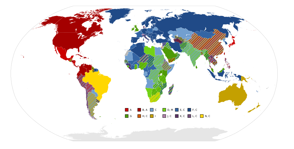
Actually it's been the 1960s when postal codes became en vogue worldwide. Blame it on the economic miracle or nascent automation, most modern systems in the First World seem to have been established in the 1960s and 1970s. If you look at countries that did their homework, you'll see that most postal codes should roughly equal the amount of mail they're supposed to get. You'd expect big cities to have a lot of postal code combinations (I don't say numbers in order to not upset our Brits) and rural codes to cover multiple villages and towns. Yet in Germany, this way only partially the case.

Both German states adopted four-digit postal codes in the 1960s, the West a bit earlier than the East and keeping reserves for reunification which weren't used when the time came. You can say that the entire Germany used to have 1,000 letter processing centers, practically one for each three initial numbers with most mail and delivery manually sorted and delivered by train. Most big cities used to have less than four digits (one or two) and when computerization mandated four digits, they were literallly "nilled up", 2 Hamburg became 2000 Hamburg and my own hometown went from 71 to 7100. In the East, two digts were the lowest. And yes, an entire big city used to have the same four-digit number as a postal code in West Germany. To compensate problems, every big city had postal zones like those in Berlin attached to after the city name. A letter to e.g. an address in the least pleasant parts of Berlin-Kreuzberg that used to have SO 36 as their zone code needed to be addressed 1000 Berlin 36. Things were different in the East where the zone code was integrated into the postal code from the start, at least in the biggest cities, so it was 1199 Berlin(-Adlershof) where East German Television broadcasted from (and a youth magazine just called itself after that number, Elf 99). If your company's Johnson grew long and strong enough to deserve an own zip code, you got a likewise own zone code. Second German Television was 6500 Mainz 500 and Otto Catalogue Delivery was 2000 Hamburg 888. This was a mess and German Unity made for a convenient moment to overhaul it from scratch. So yeah, they were too big to fit in there.

The Regime Change After The Regime Change

The five-digit system introduced on July 1, 1993 was a turning point in many ways. First of all, you needed a big register in order to find the fitting code for your desired address. More important however was the complete reorganization of mail processing.

Optical character recognition (OCR) became good enough for the majority of even handwritten postal codes on letters to be read out automatically and for the rest to go into an extra round where an officer sees any next two letters via CCTV in order to read and type in manually what's the postal code. This goes on twice a night, in the early night for the outgoing delivery and late at night for the incoming delivery. With processing becoming a quick and an entirely stationary affair, the mobile part of the delivery could be reduced to mere transport and trains could be changed for trucks and new "letter centers" were built on the greenfield from 1993 on until the last was completed in 1998. In retrospect, that must have been the year when said TV ad I mentioned in the beginning was aired. The regions may be color-coded for convenience, but the letter processing centers themselves are all interconnected to one another and the trucks go the direct route. The only real hub-and-spoke element is the International Post Center in Frankfurt where international mail is processed. The modern letter processing centers only count up to 82.

778px-Karte_Briefzentren_Deutsche_Post_AG.png


Deutsche Post also owns parcel service DHL with its European hub at Halle/Leipzig Airport. For our American readers, I'd note that the average European country is as small as a state of the US and what counts as national flights in the US would rather resemble international flights inside Europe and therefore any national airline will of course function as a hub for its nationals.

About other national systems

In most cases, the most principal region will start with a one or a zero.

The UK is an odd man out with its alphanumeric system, but even here we see a Britain-is-only-London syndrome as London's postal code regions equal their general cardinal direction inside London whereas the rest of the UK got its initial letters named after their biggest cities.
The US system starts at the East Coast from New England down south and then west. Whereas smaller countries with five digits tend to assign separate numbers for P.O. boxes and big business, the US introduced ZIP+4 for that matter and whereas the populace found it to inconvenient to adopt, modern IT knows to assign the correct plus-four appendix by the address for the comfort of USPS's mail men. For a country the size of the US, it's prudent to use three initial digits for assigning a specific SFC instead of just two as elsewhere. If independent, the most populous deserved five-digit system each on their own and the vast geography necessitates many small processing centers all over Flyover Country.
France employs its already numbered départements as the cornerstone for its postal code system, initially just using them and later, after breaking up the two old Seine (75) and Seine-et-Oise (78) départments into seven new ones (75, 78, 91-95), as initials for new five-digit codes. As initial numeration was purely alphabetic, the general region cannot directly be seen from the postal code. Most postal codes outside the big cities (where the last numbers match those of the local arrondissement) end with a zero unless it's for a P.O. box or a long Johnson under the CEDEX scheme. It's a visible compromise between old German-style parochialism and the demands of a modern urban system.
Italy is similar to France as it used its then 90 provinces in order to define its postal code areas, now there are 110 provinces and Milan's 20xxx is also shared by Monza. Yet its numeration follows some geographic logic, initial zero indicating Lazio (Rome region) and nearby Sardinia whereas otherwise running north-south.
Poland is like a French pastry called palmier or elephant ear:
It spirals out from Warsaw (0xxxx) in the east over the south to the west to spiral back into Lodz (9xxxx).
Former Czechoslovakia spirals out similarly counter-clockwise from Prague into the eastern and Slovakian lands to this day. 1 is Prague, 2 to 7 is the rest of Czechia, 8 to 0 is Slovakia.
Austria as a small country only needs four letters and, similar to France, makes Vienna's borough numbers affect their local postal codes. When I was in Vienna, I only needed to walk by a bank to know which borough I'm in and so I knew my hotel was in the XIII. Bezirk, in 1130 Wien.
 
Last edited:
You've Got Mail. Whatever It Takes. Part II

Hub And Spoke In The Comfort Of Your Own Home

At another bulletin board on the web, more exactly the most active one about (in German and English) the "Patrician" franchise of economy simulation games whose most meet-ups I attended, I drew up the following charts to illustrate for later newcomers what a hub system actually entails. Note that the German-speaker actually used "Hub-System" as a foreign word. The word itself won't denote alone if a truck either does hub-and-spoke traffic or rather does point-to-point traffic from village to village. You may also describe it as a "star system". (ZL = Zentrallager, "central store" or hub)

NB: Patrizierforum.net recently (in 2019) employed a new board software and dead-end had to be fixed.

Illustration 1: All Eggs In The Hub
index.php

Here we see that the hub contains everything money can buy in your game universe. Any city produces to much of some things and nothing of anything else and this fact necessitates trade in itself. The hub consolidates all your produce and delivery technically becomes independent from the source. Managing the routes becomes very lucid.
In real world terms, it makes transport from X to Y possible in the first place. There aren't many guests for X-to-Y journeys, but lots from X want to travel in the system and a lot of people form anywhere in the system want to get to Y. Getting from Indianapolis to Charleston necessitates going via the hub in Atlanta. The hub enables service into large areas where it otherwise wouldn't pay off, yet it can come with unnecessary detours. For parcel services like FedEx, UPS or DHL, it won't matter much as time-critical merchandise can go by air and other isn't critical, but passenger have daily lives they can't or don't want to lay off.

Whatever the reason, there are enough why multiple modes are doable for the spoke-hub paradigm, often overlapping.

Illustration 2: One Hub To Serve Them All
index.php

Players of the game that are especially convenient and have enough ships and can live for the farthest cargo to go for a week (or two with way back) can go for one central hub. In real world terms, it means you can tell Lufthansa to go screw itself. Why paying 4,000 bucks for flying non-stop from Germany to China if you can fly for less than 1,000 bucks with Air Emirates via Dubai? Or wherever in Africa or Asia a European want to go.
Fun fact: My local homegrown tour company once offered a fortnight trip to New Zealand. Their part is busing you to Frankfurt Airport and making you take the plane to Dubai and then Sydney where you stay for a night and fly to Auckland the next day. Same way back.

Illustration 3: Half-And-Half
index.php

Denmark in general and Jutland in particular divide the Hansa into North Sea and Baltic Sea and as the (standard) map is designed in order for both halves to be largely self-sufficient, save for the occasional eastern furs and western wines or clothes, it can be convenient to set up a hub in your hometown that isn't that central anyway and another hub on the other side of the map. Some things may need to be exchanged, but all in all it seems alright. In reality, that's why Atlanta is the world's biggest airport and why Denver gets by in the first place. As the only sufficiently big country of first-world prosperity, the US is currently rather alone with this kind of geographic specialization in its domestic flight market. This may change if China and India ever achieve a comparable prosperity, but both countries also have the population to sustain high-speed rail that the United States so desperately lacks.

Illustration 4: Missing The Forest For The Trees?
index.php

This illustration shows how the need for exchange rises the more insular the system becomes. Especially if you can customize your map, you'd rather go for more cities to begin with and look for most goods to be present in most areas. Routes are short and you need less ships and you still have most of the advantages of not thinking about where a city gets their goods from, you only need to think of where whole regions get one or antoher lacking good from. And worst of all, imports from the Med can't be automated anyway.
Of course, you can make a science about the exchange between the various small hubs. Direct exchange without automation, a super-hub over all those hubs, you name it.

In real life, it's evident that the biggest cities actually have the biggest airports and passenger numbers
. In a/c lingo, such mini-hubs that exist besides their major hubs are called focus cities. For a variety of reasons, it may seem impractical to employ major detours by employing the hub and a focus city is actually more of a major source and destination in itself. Denver is so isolated and small that it needs its Atlanta-style hub functions in order to be among the US top 20 in the first place but it won't get into the top 10, let alone to pole position like Atlanta.

Another part is intermodal freight transport. At that game, you could theoretically use the nearest deep water harbor as a stop on the way to the single river town behind, the spoke-hub convoy programmed for two cities and a small crayer fleet accessing the last mile to the hinterland. In reality, ISO containers are a really great thing if you don't happen to be (or have been) a dock worker in London. A part of the chain can be done by sea or air where it's absolutely necessary and maybe even more handy whereas the last mile may be done by train or truck or both. That's where container terminals employ hub functions for their hinterland whereas the interconnection of the various hubs is anarchic.
 
Last edited:
Transit the Impossible
"Normal" transit systems in normal cities usually employ radial run-through lines for their highest class of transport vehicle that somehow cross in the center. Orbital/tangential and feeder traffic are just side issues in this regard. Sometimes, things are different. Be it to the size of the town and environs, geography, insane politics or whatever.

Rendezvous Systems
One hub to rule them all. Or so I heard. This is mostly about busses.

Night line systems

They're actually the quintessential example because they're specifically designed for low demand. It's also something that most people don't use all that regularly, so the system must be easy to understand in order to see satisfying demand. Therefore you can afford to let all lines converge at one central place. Something that's insane to do by day as demand is just way too big. If a city isn't too big (i.e. under 1 million), one hub in the night should actually suffice. In Stuttgart, all night lines converge at Castle Square.

Bigger cities need more complex networks and don't get me started on cities like London that have had 24/7/365 services for ages. In Berlin, most night lines converge either at Zoo Station or Alex Station (which are likewise interconnected by lines 100 and 200) if they don't already follow the underground line courses (single-digit N lines) or are designated 24/7 M lines that already run that course by day.

Small town systems

Here they get employed by day time. In the environs of regional systems and big cities, they're nodes of combined transportation and not important here. It's rather when the city builds a hub for just that purpose. If the busses all end their services at the hub, it can become quite a hassel and interchange for inner-city purposes can get dire. If they don't, they combine the best of both worlds of radial lines and a hub system, yet having a hub in the inner city is structurally challenge. Even if no line ends in the city and U-turns happen in the outskirts, the architectural integration of the hub into the city landscape is a rather dire affair.

Near Ramstein Air Base, there's 100,000-denizen strong Kaiserslautern whose hub is just two one-way streets adjacent to the inner city and everything runs smoothly, yet the city was also razed during the war. Then there's the 75,000-denizen strong Bayreuth that needed 13 years (city council decision of 1994, grand openening by late 2007) that needed to tear down some old and not so old buildings in order to have a hub adjacent to the ring road. Then again, all busses converge there and in busy times, one half of the lines occupies the entire hub every ten minutes. They had a hub before, but through a pedestrian zone which wasn't quite ideal.

EDIT: New post for expanding the "lost" chapter
 
Last edited:
One Plug To Rule Them All? As If!

Let's talk about the proliferation of standards. In today's disposable society, it's usual to have either quick and short format wars that usually have only one winner or, in order to avoid that war, have a consortium to define a standard beforehand and avoid the problem altogether. This works fine for anything that moves.

Unfortunately, this won't work out for anything that won't move and, of course, I'm talking about AC sockets. As long as it's not absolutely necessary, they won't ever be changed. Besides the political obstacle to have the world agree on one standard, physical inertia in the buildings would take the better part of a century for the standard agreed on to achieve full worldwide penetration.

1024px-World_map_of_electrical_mains_power_plug_types_used.svg.png

NB: Yet another sinkhole on the web, but Wikimedia Commons still got it. D'oh.

What's not shown here are the different voltage worlds of 110 V to 127 V in the Americas and the Pacific (coinciding with A and B systems) and 220 V to 240 V anywhere else. What's also apparent is the US-centric labeling of standards and it's been the US Department of Commerce that gave birth to it. Just as with floppy disks, A and B stand for the sharp-angled default 2-pin and 3-pin plugs and sockets found in the US and Canada, C stands for the round jack-of-all-stats 2-pin Europlug, and so on.

If you watch the chart about AC plug and socket standards in the world, you may note some trends.


The Global Periphery Ain't No Own Standards

If a country isn't sufficiently developed enough, it won't bother to enforce any standards at all. This is generally true for agricultural subsidies and universal healthcare, but it applies to electric wall sockets too. Everything we'd call the developed world has solid standards to offer that any new installation will have to abide. Elsewhere, we see a dispersion of several systems bleeding into each other. It's a mix of old colonial legacies and derivative role models, proliferation form neighboring countries and demands from jet-travelling tourists.

Watch out for countries adopting new standards. Brazil adopted an own plug system (now called type N) which as been co-adopted by South Africa, albeit derived from an international standard and so did Thailand (now called type O). This means that said nations offer enough own prowess and a domestic market that it seems to be efficient to define an own new standard. Brazil is the biggest country and emerging market in Latin America, it also combines both voltage worlds in one country. Mere numbers helped much smaller South Africa to follow suit as it could count on international producers deliver fitting plugs for other markets anyway. Malaysia and Indonesia may be bigger than Thailand, but their colonial legacies led them to follow their old mother countries and this left Thailand as the biggest continental ASEAN country and with no colonial legacy to introduce an own standard. The Thai plug is nothing else but a very round, symmetric and therefore very generic 3-pin plug.


Path Dependencies Die Hard - Deal With It

In a perfect world, we'd all followed the Swiss after they adopted their ultra-slim and sufficiently secure 3-pin plug/socket system which it introduced in 1974 to ditch an old bulky system and which became the role model for the later IEC socket that became materialized in Brazil. Of course, this is not a perfect world and things like the German Schuko socket (type F) and the British bulge (type G) are here to stay. It's why you need a helping hand for unplugging German plugs and need to be creative for getting slim British plugs. As we're at it, did you know that the German standard actual dates all the way back to 1926?

The UK is actually the worst offender in creating a cul-de-sac system. Copper shortage due to World War II made the British employ ring-circuiting for electrifying new installations, having to provide power for all utilities in one lifeline as opposed to the less demanding hub-and-spoke systems found almost anywhere else. Said way of doing things stuck and led the way to the excessively over-engineered UK plug in order to employ even higher current in one lifeline that's the ring-circuit. It's a catch-22 nowadays. Ring-circuiting forbids abiding to any other standard in the world. The UK itself started out with later so-called type D and, as their higher amperage sisters, type M plugs which are still used in South Africa, India and environs. Australia's type I plug derived from a 1930s industrial standard adopted from the USA where it fell obsolete due to the NEMA standard (types A, B) which it shares with neighboring Canada.

Most systems, especially older ones, derived from initial 2-pin systems and that's also where they started to diverge or else. The so-called Europlug was conceived in the 1960s in order to have some kind of mutual compatibility for low-voltage items you absolutely need for traveling around. Most countries that switched from 2-pin Europlug to a 3-pin or similar system either adopted the French (type E) or German (type F) system, mostly the German with the biggest offender being Russia.

Then there are countries like Denmark that, similar to the UK, like to fall out of the line. Type K plugs were deliberately designed in order to fub off undesired foreign competition even from inside the EU, making the Danish look very French ironically if we remember SECAM or the SCART plug for anybody's VCR. Nowadays, Danish installations are also allowed to feature French and German plugs. Israel (type H) adopted its own system as if it wanted to signal being an oasis in the desert and it's also been revised, switching from sharp pins to round pins in the plugs and with the sockets accepting both. Italy just has its own system (type L) of 3 pins in a row, don't ask me why. Especially in South Tyrol, you can buy German-to-Italian adapters en masse at any supermarket because it's makes the safe plugging of fridges and vacuum cleaners so much easier as I saw in 2011: I'll never forget how Italian all the sockets were in the hotel rooms were whereas the sockets at the bottom of the hallways, where vacuum cleaners find their electricity, were so German.


Case Study: Plausible Proliferation Of Plug Standards In The Chaos Timeline By Max Sinister

Taking the rule of thumb that the Chaos TL could be considered about 50 years more advanced than OTL, we may say that there would've been initial 3-pin standards established by 1900 only to be subsequently overhauled after 1940 when political geography changed for good. Let's say that there would've been distinctive systems originating from Atlantean Germany, European Germany, the Neo-Roman Empire, both Russias in unison, Socialist Britain and maybe even China. In the latter half of the 20th century, there would've been a new standard for all the Socialist Block (possibly imprinted by similar scarcity issues as OTL Britain), the Atlantean German standard would've become the Reich standard in Technocratic Germany and proliferated into the entire Atlantis and what Max Sinister called "Canada and the Pacific", a Chinese standard would've been well established whereas the Old World Chaota may have stuck to whatever they'd had. The South Indian Confederation could have introduced the newest common standard widely employed in the late 20th century. And of course, insular systems like those in Israel or Denmark IOTL could've existed in Greater Judea or Irish-speaking Antipodia.
 
Last edited:
Loops - The Big City Variety Of Rendezvous Systems

Loops are the antipode to both Crossrail-style suburban rail systems and linear one-service-per-trunk line metro/subway/underground systems. They're necessary evils that only get employed when there's no viable alternative for whatever reason.

Australia - Loops as an ersatz crossrail

Sydney solves its rapid transit problems by letting most train traffic run through a mostly underground loop. The idea is clear: Sydney may be a big city, but it's sprawled and not dense enough to afford the number of lines necessary to pierce through its CBD in the desired quantity of rides and places and the Pacific Ocean makes the CBD an ultimate eastern terminus. The harbor is Sydney's natural cul-de-sac.

Melbourne is like Sydney, but here we see even more of a drag. Most suburban rail ended at the termini Southern Cross and Flinders Street whose very nature forbade bigger headway which it needed. Unlike Malmö in Sweden which solved a similar problem arisen from the traffic by the Öresund link by a simple crossrail or "City-Tunnel", Melbourne had more of a CBD to serve and chose to have a loop. In the meantime, it became a victim of its own success. In order to unweave Metlink services, the decision was made to consolidate the highly demanded northwestern and southeastern services into a zig-zag north-south running crossrail called Melbourne Metro Rail Tunnel bypassing all other conflicting railways in Melbourne, accessing the Loop at CBD North (Melbourne Central) and CBD South (Flinders Street). Construction is to be started in 2018 and completion is scheduled for 2026. That would be a rare instance of a city having a loop and a crossrail at the same time.

At thetransportpolitic.com, I saw a proposal from somebody who argued that the double-harbor character of Lower Manhattan demanded some kind of Australian-style loop too, maybe accompanied with a Queens-East Side-Brooklyn crossrail in order to have an interchange at Union Square.

Belgium - Medium-sized city makes amends for a proper subway

Then we have Charleloi in Belgium. Flemish-Walloon relations make for insane compromises. Flanders became its port in Antwerpen, so Wallonia needed some compensation which it got in form of the Métro Charleloi which is actually an LRT. Charleloi is way too small for a subway, hence its design is like a squid with a ring as its actual body. Only few lines were actually opened and every line serves all stations inside the ring while only serving one spoke. And as most of you know, large portions were and are unused for ages. If this hadn't happend IOTL, you'd consider this ASB, but Belgium is Belgium as we know.


The Difference That Makes The Difference: Loops Are No Circle Lines

Loops exist to easily access a number of closely situated stations, preferably in downtown, that won't line up in one direction with the same train. Circle lines on the other hand exist to provide tangential connections beyond the central interchange contour. This is special treatment for everybody because though nobody can demand to take just linear distance from A to B, cutting unnecessary detours by going orbital should be could enough for most purposes. They also offer a likewise alternative interchange contour: You don't have to remember where to change from line X to line Y if the circle crosses every line anyway. People jams become more doable too. The term "contour" comes from Moscow parlance. The non-circle exchange stations are considered to be the First Interchange Contour, Koltsevaya Line (5) is therefore the Second Interchange Contour and the final iteration of line 11, a big-ass second circle metro, is being built under the project name Third Interchange Contour.


Further reading: http://mic-ro.com/metro/metrorings.html
 
Top