You are using an out of date browser. It may not display this or other websites correctly.
You should upgrade or use an alternative browser.
You should upgrade or use an alternative browser.
Into the Cincoverse - The Cinco de Mayo EU Thread and Wikibox Repository
- Thread starter KingSweden24
- Start date
Threadmarks
View all 110 threadmarks
Reader mode
Reader mode
Recent threadmarks
2016 FIFA World Cup - Host Selection/Infrastructure 2016 FIFA World Cup - Group Stage (A through D) 2016 FIFA World Cup - Group Stage (E through H) 2016 FIFA World Cup - Knockouts 2016 FIFA World Cup Final 2016 FIFA World Cup - Main Page Dannemyer v. California NAVL Playoff First Round AnalysisFeels like such a Canada would be much more influenced by Alberta (aka Cold Texas) which is a very interesting take on things.That’s something I’ll be toying with in future updates for sure - since the Orangeism is a big part of what sees Quebec and the Maritimes exit. (I’ve settled on Rump Canada being Ontario and the West, which is a really fascinating dynamic)
So this new Commonwealth Party is supposed to be the equivalent of the NDP? It seems to me that the absence of Quebec and the fact that the country is pulled much more to the right because of the influence of Orangeism means that the Canadian Liberals are more to the right. They are never able to pivot to the left which leaves an opening for the NDP.
So Nova Scotia and Newfoundland seceded? Interesting, Wonder how they gonna develop their national identity.the Maritimes exit.
Nah. Didn’t strike me as very interesting in the endWait? Isn't BC supposed to be independent?
Oh yeah. It’s A) an easy way to complete the mission statement of flipping Canada and the US’s political orientations/reputations and B) interesting in its own right of a Canada where it’s the West that needs to actually be appeased, rather than “those Albertans are gonna make us lose votes in Montreal!”, which is quite differentFeels like such a Canada would be much more influenced by Alberta (aka Cold Texas) which is a very interesting take on things.
Yup. The CCF was indeed the OTL precursor to the NDP, and had a cooler name so I just kept that haha.So this new Commonwealth Party is supposed to be the equivalent of the NDP? It seems to me that the absence of Quebec and the fact that the country is pulled much more to the right because of the influence of Orangeism means that the Canadian Liberals are more to the right. They are never able to pivot to the left which leaves an opening for the NDP.
But yes, Orange Tories and Liberals who stay a bit more “Gladstonian” in orientation creates vast space on the left for the CCF
NB and Nova Scotia - Newfoundland was still separate Dominion until 1949 IOTL/ITTL and here never joins (same with PEI).So Nova Scotia and Newfoundland seceded? Interesting, Wonder how they gonna develop their national identity.
Of course thr Maritimes will have to have some kind of cooperation once all four are independent because each alone is quite small
Seattle Subway - Old System (Lines 1 and 2)
The Old System of the Seattle Subway, also known as the Bogue System, refers to the 6 original lines of the Seattle Metropolitan Subway that were opened prior to the 1958 Winter Olympics in Seattle, Washington and which continue today to serve as the primary core of the metro system. Originally proposed in the 1912 Bogue Plan of the City to have a 14-line system completed by 1935, work on the system did not begin until 1926 due to the Great American War followed by the uncertain economy thereafter. Starting and completing at least some of the Bogue Plan became a personal project of longtime Seattle Mayor Hulet Wells (1912-16, 1920-32), under whom the plan had initially been proposed, and in late 1925 he secured a combination of state, local and federal funds for the project as well as private donations to get to work, leading to pejorative terms of it being "the Charity Train" and the "Socialist Subway." The first train opened for revenue service in November 1931 followed by two more lines by the end of the decade utilizing the 3rd Avenue Tunnel and Dearborn Trunk, the main features of the line; today, the work on completing the Old System served as the catalyst for Seattle's robust subway system.
Line 1 - Ballard to Day Street Terminal
The first line of the system in fact ran from Queen Anne to Day Street via the 3rd Avenue Tunnel, as the shortest total route, before the 1964 reorganization of routes that rationalization the route network. At the time of the 3rd Avenue Tunnel's construction in the late 1920s, there were no bridges to the east side of Lake Washington and indeed even the Rainier Valley area was only beginning to be developed; however, the Bogue Plan had called for the construction of a grand ferry terminal at the end of Day Street on the shore of Lake Washington and the Wells administration had committed to completing that project as an effort to open up the city for "bucolic commuters" and allow Seattle residents easy access by ferry to the new state park on Mercer Island as well as areas east of the lake, and the terminal's completion in 1925 and new ferry service made it the priority. Upon opening, it was known as the Day Street Line.
The Ballard portion of Line 1 was not completed until 1948, when the Crosstown Line was opened with it; prior to this time, a stub line had run from the 3rd Avenue Tunnel to along Denny and the waterfront to underground stations on 15th Avenue near the Washington National Guard Armory and then south of the Fishermen's Terminal on Salmon Bay at the intersection of 15th and Dravus Street; this line served as the "western" terminus of the Mount Baker Line which opened in 1934 as the second component of the system (under the initial plan, every line of the Old System was named using its terminus east of the Dearborn Trunk). The extension from Dravus and 15th (today Dravus Street) to Ballard's Market Street station was completed in 1948 with the opening of the Crosstown Line's initial segment; in 1958, the extension to the city limits at 85th Street was completed. A debate around the optimization of the lines began after the Olympics, and the city soon thereafter elected to reorganize the various lines so that they would all have more similar total lengths, and with that the Day Street Line service was re-routed onto the 15th Avenue-Ballard tracks, and in the 1980 reorganization rebranded as Line 1 to commemorate it being the first line in the system (other line numberings were unrelated to the line's age or order, save Line 2 from Queen Anne). On the subway route map, the train's roundel is dark green.
The route of Line 1 begins at Golden Gardens Station under 85th Street, the city's northern limits, near the entrance to Golden Gardens Park, underneath which lies turnaround tracks. From there it follows a diagonal route to 75th Street, after which it runs south under 22nd Avenue. There is a station at 65th Street/Ballard North (the second addition to the name added in a 1992 system-wide station rebrand) and then the route continues to the station at Market Street, in the center of Ballard. Here, the Crosstown Line splits off, and Line 1 continues under the Lake Washington Ship Canal to the Dravus Street station at the junction of 15th Avenue and Dravus Street, between western Queen Anne and eastern Magnolia. Running under 15th Avenue for a kilometer and a half, the route next stops at the base of the Magnolia Bridge at the Magnolia station, and shifts onto tracks underneath Elliott Avenue before turning east on Denny, with a stop at Denny West (formerly Denny and 1st) before entering the 3rd Avenue Tunnel.
In the 3rd Avenue Tunnel, Line 1 enters Civic Center Station, one of the major transit hubs of the city through which four other lines pass as the first station at the north end of the tunnel. Following this station, it passes through the rest of the 3rd Avenue-Dearborn Trunk mainline, stopping at Pike Street (where it connects to Line 7), Spring Street, Pioneer Square, Jackson/Union Station (where it connects to commuter rail lines and the Seattle Streetcar), then into the Dearborn Trunk where it stops at Dearborn Street/Chinatown station and can connect to lines using the New Dearborn Trunk platforms immediately to its south. Following this, it finally passes through Judkins Park Station and then ends beneath the Day Street Terminal on Lake Washington for a total route length of 16 kilometers.
Line 2 - Wallingford to Lake City
The Queen Anne route originally was part of the Day Street Line when the system opened in 1931, burrowed deep under the tall Queen Anne Hill and one of the major reasons it took so long to build. The stations on this line are notorious for the time it takes to descend down into them and the cramped confines of the stations and narrow platforms; nonetheless, upon its opening, it connected residents of wealthy Queen Anne to downtown and Day Street, allowing them easy access to leaving the city to environs east, an ironic choice of first routing considering Mayor Wells' Socialist affiliations. The routing choice may thus be ascribed to the ample donations that Queen Anne residents levied. The Lake City Line was the third line built, opened in December 1939, and upon its opening the longest route in the system, forming a U shape with an extension up to nearby Green Lake, thus connecting the north of the city via a detour down into downtown. Nonetheless, today the Lake City Line's infrastructure - in particular the 27th Avenue Tunnel on Capitol Hill - forms some of the most important segments of the line with the highest frequencies. Upon opening it was the longest line in Seattle, and was shortened with its rationalization in the 1964 re-route. The line was initially built only to Ravenna and the city limits; by 1950, an extension combining elevated tracks after the 82nd Street Station brought it all the way up to Lake City, making it the first and for two decades only line to leave the City of Seattle. The Line 2 Extension, also known as the Fremont Avenue Extension, began in the late 1980s and was completed in 1991 as one of the city's major longtime priorities, crossing the Ship Canal with an extension via Fremont to Woodland Park.
The route begins at Woodland Park, with turnaround tracks under the zoo's parking lot, and heads south along Fremont Avenue with a connecting stop with the east-west Line 4 at 45th & Evanston. It then continues down to Fremont, stopping there, before passing under the Ship Canal to its 1930s-era route with three stations under Queen Anne Hill, the aptly named North Queen Anne, Upper Queen Anne and Lower Queen Anne. Following its sojourn deep under Queen Anne Hill it passes under Expo Park, with a station immediately in the center of the campus, before entering the 3rd Avenue Tunnel just south of Denny, thus utilizing the same tracks as Lines 1, 3, 5 and 13 all the way to Dearborn Street/Chinatown.
After leaving the 3rd Avenue-Dearborn Mainline, Line 2 turns north to its station at 23rd Avenue, entering the 27th Avenue Tunnel trunk and going north through eastern Capitol Hill, with stops at Alder, Pine Street (where it connects with Line 7's east-west route), Madison Street, and Arboretum at the edge of the Lake Washington Arboretum. It has a stop in the Montlake neighborhood, at the end of Evergreen Point Floating Bridge, and then continues under the Ship Canal to the University of Washington Transit Center at the south end of the university's campus, across Montlake Avenue from the stadium complex, one of the busiest stations in the network as a bus and subway hub. It then travels north under Montlake to the University Village station, with its connection to Line 4 - now elevated - and then continues to Ravenna station at the city limits at 65th Street, which upon opening in 1939 was the terminus. The route continues on the Lake City Extension underground beneath 25th Avenue to 82nd Street/Seattle University (formerly 82nd Street) in Sand Point, then continues into Lake City on elevated tracks north of the confluence of Lake City Way and Ravenna Avenue. This elevated extension has three stops - Lake City South/110th Street, Lake City Central, and Lake City North/145th Street, its terminus adjacent to a maintenance yard at Lake City's northern city limits. The route is a total length of 27 kilometers.
Or to use a more recent example, Ken Livingstone (former head of the London Council) beginning his first speech as Mayor several years later with "As I was saying before I was so rudely interrupted..."I'd say continue from the original count. I'm reminded of the first meeting of the modern Scottish Parliament in centuries, and the first speaker stated that they were effectively back from a long recess")
I love it!The Old System of the Seattle Subway
1908 United States presidential election
The United States Presidential election of 1908 took place on November 3, 1908, the 31st quadrennial Presidential election. Incumbent President William Randolph Hearst, a Democrat, was reelected over the Liberal nominee, former Pennsylvania judge Samuel W. Pennypacker.
A charismatic orator popular with the general public and coming off of one of the most legislatively productive first terms in American history, while buoyed by a growing economy that had mostly recovered from the depression of 1904, Hearst was regarded as extraordinarily difficult to defeat and was seen as the far-away favorite for most of the campaign. While harried in much of the Liberal-leaning press, Hearst nonetheless sported an efficient and innovative public relations campaign that relied on the network of his friend, press baron and Mayor of New York Theodore Roosevelt, to get his message across, and enjoyed strong support from a broad swath of Democratic intermediaries from Congress; his renomination was never in doubt. Having lost the 1904 election badly and not wanting to be embarrassed in 1908, most prominent Liberals elected to sit out the election, resulting in the nomination of obscure Pennsylvania state judge Samuel W. Pennypacker, a failed gubernatorial nominee who was nonetheless picked as a figurehead whom Liberal grandees felt would be difficult for Hearst to attack on policy.
The choice badly backfired. Pennypacker revealed his politics to be reactionary and promised to undo much of the Hearst "Fair Deal" program if elected, and a series of unpopular Supreme Court decisions in the leadup to the conventions and fall campaign allowed Hearst to credibly paint Pennypacker as a hack judge cut from the same cloth as the controversial Chief Justice of the Supreme Court George F. Edmunds, whom Pennypacker became associated with by default. In the end, Pennypacker lost by a wider popular vote and electoral vote margin than Senator Charles Fairbanks four years earlier as Hearst ran a vigorous campaign on defending and building upon his own achievements. The incumbent won by a more than fourteen-point margin and collected a staggering 417 electoral votes and winning all but five states, including Pennypacker's home state of Pennsylvania, failing only to carry the New England region. It remains one of the most lopsided electoral results in post-1863 American history.

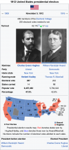
(@GDIS Pathe and @flyingmongoose were kind enough to make election infoboxes for the 1908 and 1912 Presidential elections, as well as the 1914 Senate elections, so I am reposting them here in full Wikipedia article form.)
A charismatic orator popular with the general public and coming off of one of the most legislatively productive first terms in American history, while buoyed by a growing economy that had mostly recovered from the depression of 1904, Hearst was regarded as extraordinarily difficult to defeat and was seen as the far-away favorite for most of the campaign. While harried in much of the Liberal-leaning press, Hearst nonetheless sported an efficient and innovative public relations campaign that relied on the network of his friend, press baron and Mayor of New York Theodore Roosevelt, to get his message across, and enjoyed strong support from a broad swath of Democratic intermediaries from Congress; his renomination was never in doubt. Having lost the 1904 election badly and not wanting to be embarrassed in 1908, most prominent Liberals elected to sit out the election, resulting in the nomination of obscure Pennsylvania state judge Samuel W. Pennypacker, a failed gubernatorial nominee who was nonetheless picked as a figurehead whom Liberal grandees felt would be difficult for Hearst to attack on policy.
The choice badly backfired. Pennypacker revealed his politics to be reactionary and promised to undo much of the Hearst "Fair Deal" program if elected, and a series of unpopular Supreme Court decisions in the leadup to the conventions and fall campaign allowed Hearst to credibly paint Pennypacker as a hack judge cut from the same cloth as the controversial Chief Justice of the Supreme Court George F. Edmunds, whom Pennypacker became associated with by default. In the end, Pennypacker lost by a wider popular vote and electoral vote margin than Senator Charles Fairbanks four years earlier as Hearst ran a vigorous campaign on defending and building upon his own achievements. The incumbent won by a more than fourteen-point margin and collected a staggering 417 electoral votes and winning all but five states, including Pennypacker's home state of Pennsylvania, failing only to carry the New England region. It remains one of the most lopsided electoral results in post-1863 American history.
(@GDIS Pathe and @flyingmongoose were kind enough to make election infoboxes for the 1908 and 1912 Presidential elections, as well as the 1914 Senate elections, so I am reposting them here in full Wikipedia article form.)
Attachments
Last edited:
The maps look really similar. Great minds think alike I suppose.Was re-reading this for like the 50th time and decided to make a wikibox for the 1908 election, mainly because of the HearstSlide:
View attachment 771046
D’oh! Looks like the 1908 one was yours! My apologies, I shall correctThe maps look really similar. Great minds think alike I suppose.
The Wiki giveth, the Wiki taketh.In magnifying the images, it is clear that West Virginia has OTL borders, including its OTL easternmost counties. OTOH, I have *no* idea what it would take to correct that.
chalk it up to “close enough” - I’m just flattered there are fans who make wikiboxes of TLs I write!
My God it's beautiful.The United States Presidential election of 1908 took place on November 3, 1908, the 31st quadrennial Presidential election. Incumbent President William Randolph Hearst, a Democrat, was reelected over the Liberal nominee, former Pennsylvania judge Samuel W. Pennypacker.
A charismatic orator popular with the general public and coming off of one of the most legislatively productive first terms in American history, while buoyed by a growing economy that had mostly recovered from the depression of 1904, Hearst was regarded as extraordinarily difficult to defeat and was seen as the far-away favorite for most of the campaign. While harried in much of the Liberal-leaning press, Hearst nonetheless sported an efficient and innovative public relations campaign that relied on the network of his friend, press baron and Mayor of New York Theodore Roosevelt, to get his message across, and enjoyed strong support from a broad swath of Democratic intermediaries from Congress; his renomination was never in doubt. Having lost the 1904 election badly and not wanting to be embarrassed in 1908, most prominent Liberals elected to sit out the election, resulting in the nomination of obscure Pennsylvania state judge Samuel W. Pennypacker, a failed gubernatorial nominee who was nonetheless picked as a figurehead whom Liberal grandees felt would be difficult for Hearst to attack on policy.
The choice badly backfired. Pennypacker revealed his politics to be reactionary and promised to undo much of the Hearst "Fair Deal" program if elected, and a series of unpopular Supreme Court decisions in the leadup to the conventions and fall campaign allowed Hearst to credibly paint Pennypacker as a hack judge cut from the same cloth as the controversial Chief Justice of the Supreme Court George F. Edmunds, whom Pennypacker became associated with by default. In the end, Pennypacker lost by a wider popular vote and electoral vote margin than Senator Charles Fairbanks four years earlier as Hearst ran a vigorous campaign on defending and building upon his own achievements. The incumbent won by a more than fourteen-point margin and collected a staggering 417 electoral votes and winning all but five states, including Pennypacker's home state of Pennsylvania, failing only to carry the New England region. It remains one of the most lopsided electoral results in post-1863 American history.
View attachment 816528
(@GDIS Pathe and @flyingmongoose were kind enough to make election infoboxes for the 1908 and 1912 Presidential elections, as well as the 1914 Senate elections, so I am reposting them here in full Wikipedia article form.)
Not quite “as goes Maine, so goes Vermont” but it’s damn closeMy God it's beautiful.
Noticing the election box and Delaware's*FOUR* Electoral votes
iOTL, Delaware has *never* divided the state into two different congressional districts, with the 1810 Census giving them a second seat (which they had at-large) and the 1820 census taking it away (electing two representatives in the 1812, 1814, 1816, 1818 and 1820 congressional elections. Does Delaware divide the state iTTL?
iOTL, Delaware has *never* divided the state into two different congressional districts, with the 1810 Census giving them a second seat (which they had at-large) and the 1820 census taking it away (electing two representatives in the 1812, 1814, 1816, 1818 and 1820 congressional elections. Does Delaware divide the state iTTL?
Perhaps it still goes at-large? If it wants to be weird about splitting that isNoticing the election box and Delaware's*FOUR* Electoral votes
iOTL, Delaware has *never* divided the state into two different congressional districts, with the 1810 Census giving them a second seat (which they had at-large) and the 1820 census taking it away (electing two representatives in the 1812, 1814, 1816, 1818 and 1820 congressional elections. Does Delaware divide the state iTTL?
Maybe, the supreme court decisions that got rid of state at large members of congress (in states that had more than one representative) were based on the Voting Rights Act. (so 1910 iTTL is certainly reasonable.Perhaps it still goes at-large? If it wants to be weird about splitting that is
Right, preciselyMaybe, the supreme court decisions that got rid of state at large members of congress (in states that had more than one representative) were based on the Voting Rights Act. (so 1910 iTTL is certainly reasonable.
I know obviously it wouldn't happen but California having 53 at-large seats would be extremely funny.Right, precisely
At that point they may as well just go proportional lolI know obviously it wouldn't happen but California having 53 at-large seats would be extremely funny.
Threadmarks
View all 110 threadmarks
Reader mode
Reader mode
Recent threadmarks
2016 FIFA World Cup - Host Selection/Infrastructure 2016 FIFA World Cup - Group Stage (A through D) 2016 FIFA World Cup - Group Stage (E through H) 2016 FIFA World Cup - Knockouts 2016 FIFA World Cup Final 2016 FIFA World Cup - Main Page Dannemyer v. California NAVL Playoff First Round Analysis
Share: