Groß-Deutschland map

JJohnson

Banned
One other question - which Polish city would be a good candidate for the new capital, with Warsaw being a German city? Lublin?

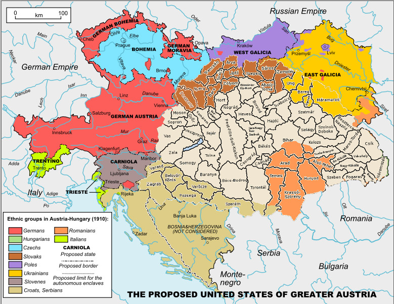
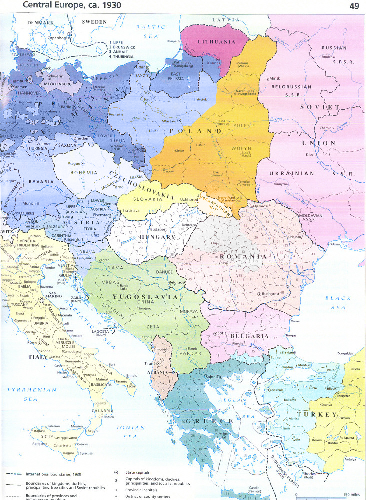
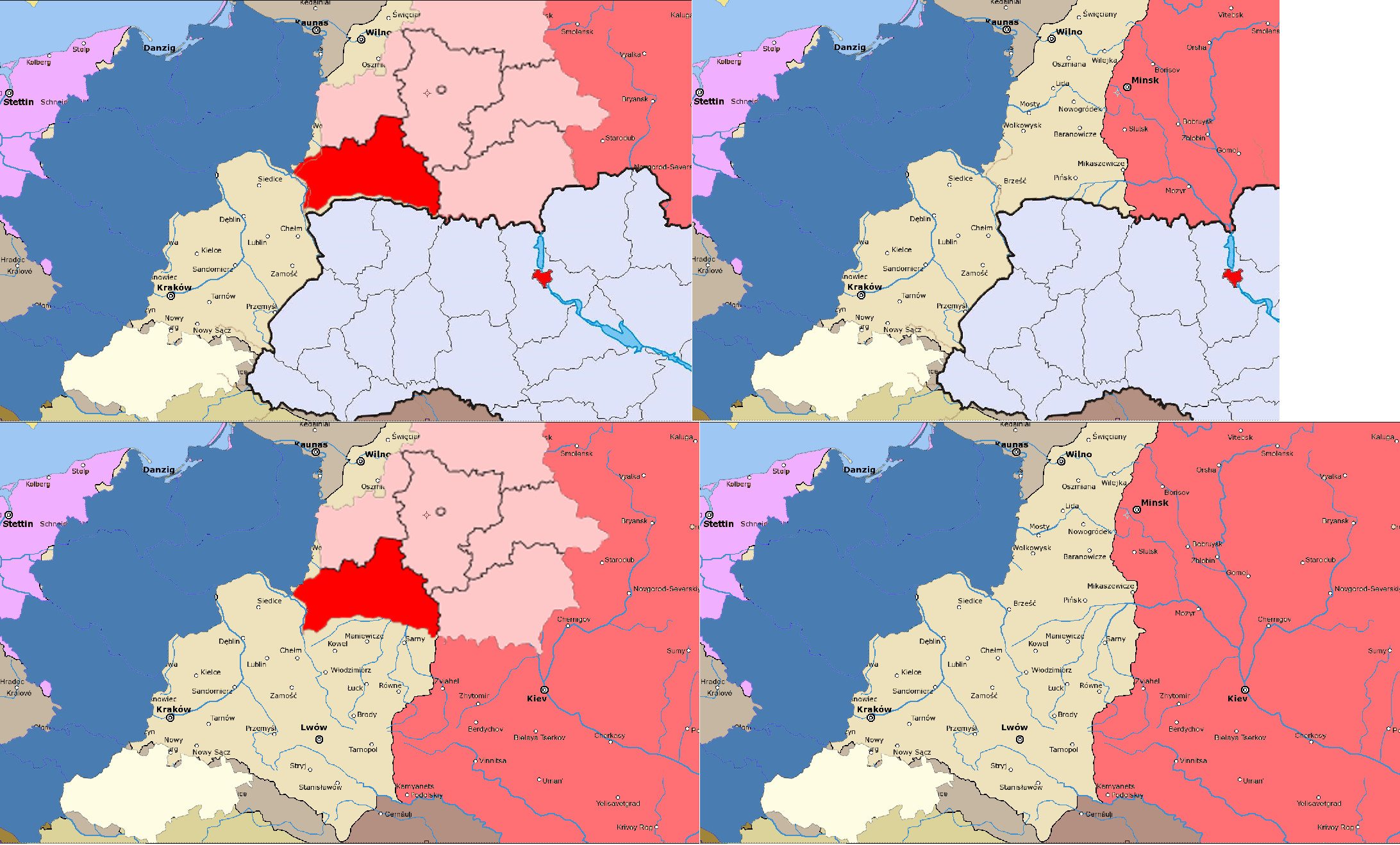
For the post-WW2 Poland, utilizing the remainder of interwar Poland's borders, would it be reasonable to add the following territory east:
From Ukraine: Volyn, Lviv, Ivano-Frankivsk, Zakarpattia, Chernivtsi, Rivne, Khmelnytsky
From Belarus: Brest, Hrodna

and Ukraine gets: Belgorod and Kursk from Russia.

I'm half-and-half, as Poland has blame for the war, but then again, with 25 - 30 million people, how would they eventually prosper in the 20th century with such a land?
 
Last edited:

JJohnson

Banned
The 1946 Germany would look great as an overlay to this map. For individual states, I'm about to post a wiki-style png for each state.

Example:

Bavaria_by_JJohnson1701.jpg
 
Last edited:
Zakarpattia should belogn to Hungary not to Poland, as it never was a Polish province and until the the Treaty of Trianon was part of Hungary, so it should not be part of Poland.
Also if Poland is so badly defeated it should have no eastern territory.
It should be small statlet copmrised of the reminder of Congress Poland, and Polish parts of Galicia probably without Lvov.
 

JJohnson

Banned
They are defeated, the only thing is that there are around 27 million Poles just before WW2, and even taking into account war casualties, starvation, executions, and all the other bad things that happen in war, there's at least 22-25 million Poles. Leaving simply the remainder of Interwar Poland didn't seem enough territory for them, especially since the Allies would want to 'de-russify' them to get rid of the extremism. For that, they'd need enough land to prosper post-war so the kind of inter-war extremism ITL Poland and France doesn't re-occur. Keeping Brest and Hrodna, as those were Polish territory, which OTL Ukrainian territory would be used?
 

JJohnson

Banned
This is a (Very) rough comparison utilising Interwar Poland, with Groß-Deutschland, and OTL Belarus and Ukraine. Much of the lower portion of Poland went to Ukraine after WW2 in our timeline due to Russia shifting the Curzon line.

Poland_Area_Comparison_by_JJohnson1701.jpg
 

JJohnson

Banned
And here I thought Krakow was part of Germany.... :)

From Ukraine, at least Volyn, Rivne, and Lviv; Belarus's Brest and Hrodna, since those were already part of Interwar Poland.

Interwar Poland had Stanislav and Tarnopol, now Ivano-Frankivsk and Ternopil, Ukraine. Only problem there, is it cuts off Zakarpattia from Ukraine, unless we're moving Romania also. Transylvania should remain mosly Hungarian since after WW1 it still held a sizable Hungarian population.

From the above picture, slide 1 doesn't give enough room for about 25 million people, so that's out.

A quick calculation using slide 4 - the area of that Poland is roughly 257,700 km2. Is that enough?
 
Last edited:
Here is my idea on Polish borders, I think it's the maximum that Germany would allow.
I think I drew the Slovak-Czech border wrong, could somebody correct it?

Poland borders.PNG
 

JJohnson

Banned
For Romania, I would say they don't lose counties to Ukraine, Bulgaria, or have an independent Moldova created. Transylvania, being part of the Kingdom of Hungary, would have to be gone through county-by-county. This is a preliminary version of Hungary:

Hungary_Division_by_JJohnson1701.jpg
 
Last edited:

JJohnson

Banned
Possible Europe:


I gave Subcarpathian Rus to Poland, and some counties of Romania back to Hungary so they can have territorial continuity

Europe_Division_by_JJohnson1701.png
 
Here is my idea, , Poland has Vilnius and Lvov, Ukraine is extended to the Volga and has the Kuban region.
In Transilvania Hungary has Crisana, Szeklerland and a corridor to connect them which has Cluj and Maramures.
The areas yu gave Hungary are to large.

europe borders.PNG
 

Susano

Banned
Here is my idea, , Poland has Vilnius and Lvov, Ukraine is extended to the Volga and has the Kuban region.
In Transilvania Hungary has Crisana, Szeklerland and a corridor to connect them which has Cluj and Maramures.
The areas yu gave Hungary are to large.

Turkey and Russia always get the shaft dont they:rolleyes:
Whats up with the Greek Aegan Coast?
 

JJohnson

Banned
As for population, using straight out numbers from today, it would be around 133,050,711 people. This isn't taking into account Germany didn't suffer as much in the way of WW2 losses and such.
 

Susano

Banned
As for population, using straight out numbers from today, it would be around 133,050,711 people. This isn't taking into account Germany didn't suffer as much in the way of WW2 losses and such.

OTOH I assume it takes into account Polish population that never was transferred to those areas ITTL because of no WW2.. 133m seems a bit much even with BeNeLux. Id simply take the German population, BeNeLux and the western gains, and multiple with 1.1 or 1.2 for the lacking war losses and the Polish minority...
 

JJohnson

Banned
Those figures didn't take into account the Polish transfers into the region don't take place, I was using OTL numbers. I didn't include Benelux as part of Germany...

Using your multiplier, I'm assuming WW2 population figures for the territories to draw them towards present day. It'll take a moment to calculate that...

In WW1, Britain, Germany, and Italy were on the same side ITL; France, Russia, and the Ottomans were the bad guys (historically speaking)

In WW2, France, Spain, Italy, Poland/Russia, and Japan formed the Axis, and the Allies included the US, Republic of China, Germany, UK, Hungary, and Italy (after Mussolini falls).

I'm not totally sure of the relationship of Poland to the USSR after WW2, as I was thinking they were a puppet state in a way, with a lot of Soviet agitators, leading them to side with France's fascists...
 

JJohnson

Banned
In making the Wiki articles for Groß-Deutschland, I'm looking to make the little pushpin maps, but they rely on geo-data that's different in our new Germany. Would someone be able to help me out with this?

Blomma, if you had a bit of time, could you take this map of the counties into the states of 1871/1898 for the wiki?
 

JJohnson

Banned
Government forms: here

Which French colonies will go to Germany, vs. going to Britain?

I'm thinking the following divisions:

Italy: Corsica, North portion of Tunisia, Libya, Eritrea, Somaliland

UK: Reunion, Madagascar (small portion to Germany for port/refueling), French Guinea, Portuguese Guinea, Senegal, Portuguese East Africa, German East Africa, Niger, Algeria, Tunisia, Morocco, Comoros, Spanish Morocco, Rwanda-Burundi, portions of Belgian Congo to allow further territorial continuity from Cape-to-Cairo.

Germany: French Southern and Antarctic Lands, New Caledonia, Mayotte, French Polynesia, French Sudan, Portuguese West Africa, Guinea-Bisseau, Benin, Burkina Faso, Mauritania, Gabon, French Congo, Central African Republic, Chad, Morocco "Western Sahara", Djibouti, Madagascar region "Antsiranana", Spanish Guinea, German SW Africa, German Togoland, German Cameroon, portions of Belgian Congo to allow land continuity between Mittel- and Südafrika

USA: Clipperton Island, Saint Pierre and Miquelon (1800), Saint Martin and Saint Barthélemy, French Guiana (1800), Guadalupe (1803), Martinique (1803), Wallis and Futuna, Cape Verde Islands, São Tomé e Príncipe

(this is the US from my New World timeline)
 
Top