Engineering A Planet

Instead of cluttering the Map Thread with a milion drafts, I figured I'd make a seperate thread to contain the images and text, and to make it simpler for me to mine you all for information.

So I wanted to say thanks to Oddball for the URL references. I realize now I should have looked at pressure systems first instead of wind patterns (I was dealing with symptoms rather than causes). So thanks again Oddball, here is the fruit of your help!

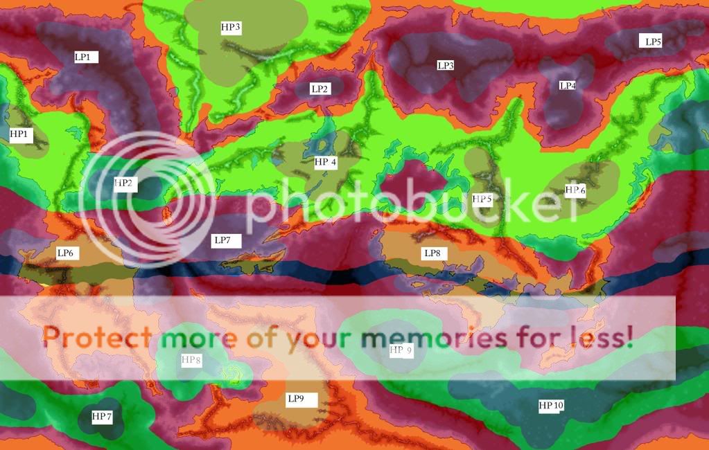
Here we have first the world map, in January. Going off the data from the provided websites, I garnered the following concepts:

1. Water is a heat capacitor, creating low pressure systems when surrounding land is colder, and high pressure systems when land is warmer.

2. Land temperatures change rapidly (relatively), causing isolated high and low pressure systems (isolated from the air cells) which then merge with the systems created by the air cells.

So January:
experimentinwindpatterns-january.jpg


The black band around the 'equator' is what I think should be the Inter-tropical convergence zone (ITCZ). It doesn't follow the equator, rather it depends on land patterns due to the variations in heating between land and water.


And July:
experimentinwindpatterns-july.jpg


I'm looking for plausibility, but i'd settle for reasonable ;).

I'll go into detail later about how I think the winds would flow from these pressure systems. I first want to see if I'm on the right track.
 

VT45

Banned
:eek::eek::eek::eek:

Azardin, you are absolutely amazing! If ever I need climatological models for a planet I'm creating, I'm coming straight to you.
 
So I wanted to say thanks to Oddball for the URL references. I realize now I should have looked at pressure systems first instead of wind patterns (I was dealing with symptoms rather than causes). So thanks again Oddball, here is the fruit of your help!

You are most welcome :)
Always nice to be of asistance :)

IMHO your thanks should go to the creator of those web pages :cool:

Like you I find them very informative. Unlike you I have not put them to use yet :eek:

For those who wonders:

http://www.cix.co.uk/~morven/worldkit/index.html

http://www.cix.co.uk/~morven/worldkit/climate.html
 
Shit. Noticed a mistake on my part. The maps are flipped. First one is July, second is January. Sorry.

:eek::eek::eek::eek:

Azardin, you are absolutely amazing! If ever I need climatological models for a planet I'm creating, I'm coming straight to you.

Thanks, and I'd be happy to help.

Now, my thoughts on the general direction of wind flow takes into account the Coriolis Effect but flipped direction due to the opposite rotation of the planet.

Starting the the High Pressure systems (HP1, 2...) on the January map (NOTE: Map 2), I would think that one would see winds flowing generally out in all directions, but due to Coriolis forces and terrain, a counter clockwise air current would form. Below 30 degrees north, the winds are going to flow with a general southern angle and above 30 degrees, a general northern angle. Picking up moisture over the large lake, and any other bodies of water on the continent, these winds will enter into the low pressure zone along the coast. The poor people of that northern coast, looks like rough winters. At the same time, it looks like one would be able to ride those same winds along the coast, if one was brave enough to weather the storm.

There will be a general flow of air from the high pressure zones around LP1 into LP1, combined with topography and Coriolis, it looks like there would be a nice trade wind pattern, albeit probably rough.

HP2 is like our own tradewinds in the equatorial Atlantic, but reversed.

HP3 pretty much sits at the pole and keeps it cold and clear. What water does evaporate will flow southwards down the central valley as well as the other valleys to the coast. Winters here are going to be very dry and cold. The bulk of the center of that continent will be dry in the winter, unless I dot it with lakes (similar to NA after the ice ages?)

The air flowing out of HP3 and HP4 into LP2 would drive a clockwise wind current around that sea. (which kicks ass, since thats what I arbitrarily thought up in the novel:D) More of the same across the large northern ocean. LP3-5 all suck in air and with the addition of HP5 and HP6 creates a very elongated wind pattern (This actually is connected to the air flows about HP1 and LP1). Useful in concept, but in practice I'd think the northern coast would be icey and dangerous to much shipping (Something of a NW Passage, but real, and east?)

The low pressure system on the sea between HP4 and HP5 would have a counter clockwise wind blowing from the northern coast along the western shores, until a sailor would have to cut north from the middle of the southern coast to keep usign the wind.

There would be a west to east flow along the southern ends of HP5 and HP6, carrying water along with it. Most of the water will fall on the northern slopes of the mountain ranges, but where the wind has a clear path it will carry moisture well into the interior. Also note, due to those mountains that prevent the winds from HP5 and HP6 truly watering the lands to the south, the winds off HP4, dried over the land they formed in but picking up mostuire as they cross several hundred miles of ocean slam into the southern slopes of the same mountains.

LP6-8 are all like this. Winds carry moisture into them and being along the ITCZ (the gray band) causes quite a bit of evaporation. These pressure zones are where the huge rainforests are.

HP7-10 are areas of ocean that remain cooler than the land around them (remember, this is the southern hemisphere's summer) The main low pressure system (LP9) is on the southern continent and largely held in place by the mountain range (a bowl of air, is the way I look at it). LP9 then sucks moisture off the ocean from HP8 and as the wind blows the water eastward, it falls as rain as the mountains force the water upwards. The eastern shore would be a desert.

Except, we have the high pressure zones 9 and 10. HP9 has an outward flow from it in a clockwise motion, picking up moisture and dropping it along the coast. HP10 performs similarly but due to the latitude most of the moisture would be pretty damn cold. It looks like the Penguins will need umbrella's.

HP7's air flow is the only breath of life to the otherwise dry desert that lies between the two mountain ranges almost directly north of HP7. The wind flowing in will pick up some moisture (not much mind you, it is cold air after all) and drops it on the land. I would wager the interior would be dry and hot almost year round, while the coast in the summer might get closer to some mediterranean climes.
 

Thande

Donor
Azardin, would you be interested in looking at other people's fantasy/alien world maps and giving your opinion on what the climatic zones would be like? I don't mean in as much detail as this, obviously. We can pay yolu back with our own specialisations, such as the Secrets of Flag Waviness ;)
 
Azardin, would you be interested in looking at other people's fantasy/alien world maps and giving your opinion on what the climatic zones would be like? I don't mean in as much detail as this, obviously. We can pay yolu back with our own specialisations, such as the Secrets of Flag Waviness ;)

I'd be happy to help, this is certainly not going to be my strongest point, but I'm fairly good with taking in several layers of data and keeping them pretty much running in 'RAM' in my head for a while, especially when it comes to spatial data. (I played with blocks and legos as a kid, can't you tell? :D)

I think I'm going to keep working on the data for my map, but if anyone else wants to post a map/ link to one, I'll certainly give my best two cents for it (mind you, I'm in Germany now...2 cents Euro is like a billion US $, with what the dollar is at now ;))
 

Thande

Donor
I think I'm going to keep working on the data for my map, but if anyone else wants to post a map/ link to one, I'll certainly give my best two cents for it (mind you, I'm in Germany now...2 cents Euro is like a billion US $, with what the dollar is at now ;))
Worth even less to the GBP, so that's all right ;)

Whenever you have a moment, what are your views on this?

The brown lines are mountain ranges; ignore the other colours, it was just my guess at what the rough climatic regions would look like when I made it.

Topographical map.GIF
 
Worth even less to the GBP, so that's all right ;)

Whenever you have a moment, what are your views on this?

The brown lines are mountain ranges; ignore the other colours, it was just my guess at what the rough climatic regions would look like when I made it.
Ooh, pretty map. What's it for?
 

Thande

Donor
Ooh, pretty map. What's it for?

Have you not seen my Moonstruck stories? It's Vároton, homeworld of the Vároto (and before anyone complains about the planets of alien races having unrealistically convergent names, both they and it were named by another race, OK? :rolleyes: )
 
Thande-1.jpg


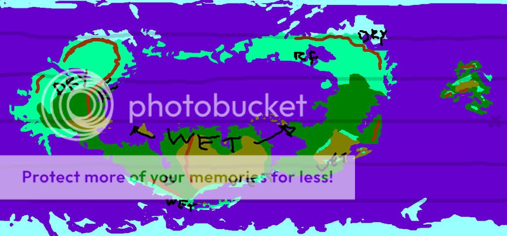
Here you go! The text is sloppy because i'm using a mouse. I'd recommend a wacom tablet for anyone who as one for this sort of thing normally. RF is rain forest, at least, areas I'd supposed would have a good amount of moisture. Depending on latitude the type of rain forest would vary, naturally, but i looks like most of the world is pretty wet. Winters could theoretically be dry in some areas of the northern hemisphere, (mainly the island in the northwest corner) but due to that large central ocean (which you were so kind enough as to make it round :D) the supercontinent is going to be pretty wet and mild year round.

You got some nice trade winds blowing along the coasts in both seasons two, but I'd stay out of the southern seas... all the arrows were colliding and such in the low pressure areas...liable to be nasty weather... or Bermuda triangle locations.

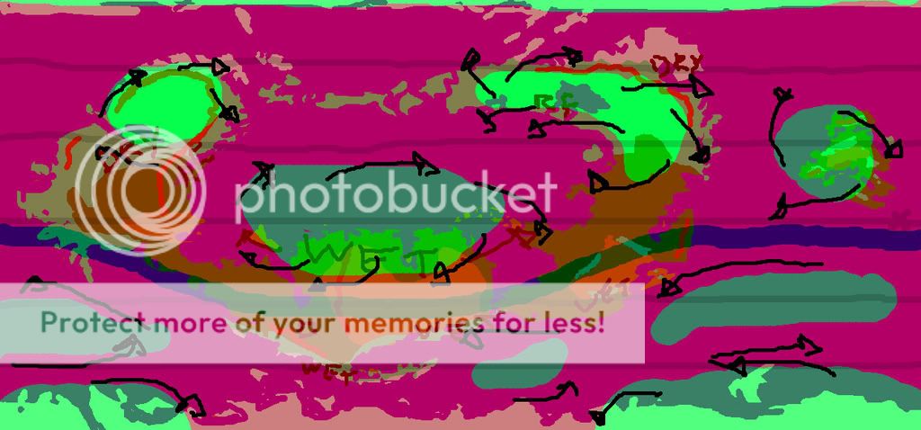
If you want a pic with what I reasoned for the seasonal winds, I can do that too.
 

Thande

Donor
If you want a pic with what I reasoned for the seasonal winds, I can do that too.
Thanks! Sure, if you have time, do the winds as well.

That's predictably quite far from what I'd originally laid down, but that's not really a problem - Vároton geography is quite fluxional at the moment in my mind and I can just relocate the Shaa Desert farther westward ;) Ironically, your version of Ucasphorm actually fits the description in my book rather better than that map I originally did... :rolleyes:
 
Wow. That's amazing. Is it voodoo?

I'm afraid you've got me at a loss Admiral.

Thanks! Sure, if you have time, do the winds as well.

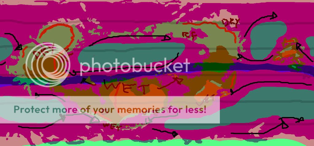
Not an issue, it helps sketching it out in CS3, now that I got the hang of the process, its relatively simple to keep several layers and go between them.

Wind patterns in January (Or just northern winter, dunno what the Vároto call January)
Thande-winterwinds.jpg


And July
Thande-summerwinds.jpg


That's predictably quite far from what I'd originally laid down, but that's not really a problem - Vároton geography is quite fluxional at the moment in my mind and I can just relocate the Shaa Desert farther westward ;) Ironically, your version of Ucasphorm actually fits the description in my book rather better than that map I originally did... :rolleyes:

Well thats quite handy, always good to insert a little extra support to something. Though I don't really know where you'd be able to put a big desert, the way it looks to me you got a rather wet world. Good for life, although since its an enemy planet...not so good.
 
Last edited:

Thande

Donor
Not an issue, it helps sketching it out in CS3, now that I got the hang of the process, its relatively simple to keep several layers and go between them.
Thanks very much! :cool:


Though I don't really know where you'd be able to put a big desert, the way it looks to me you got a rather wet world.
Well, it is supposed to be pretty tropical in my envisionment (is that a word? ;) ) but there are a couple of deserts. I think they can go in the dry areas you've labelled between the mountain ranges.

Good for life, although since its an enemy planet...not so good.
Ah well, whose enemy? ;) It's all a point of view...

EDIT: By the way, the irony is is that your username sounds rather like it could be a continent on this planet, as I named them (years ago) as things like Tzardin and Czaarlin :D
 
EDIT: By the way, the irony is is that your username sounds rather like it could be a continent on this planet, as I named them (years ago) as things like Tzardin and Czaarlin :D

Cool, perhaps then I'm one of your continents come to life and am just a manifestation of it on the internet. :D

And thanks for the well wishes too Glen!

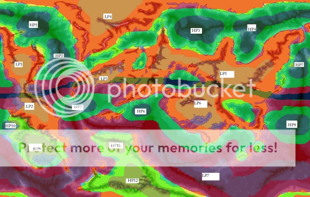
Now, for a bit on my planet. Scrolling up reveals my thoughts on the patterns in the winter, but winter sucks cause its cold. Lets go where its balmy and perhaps there are tropical girls with alcoholic beverages.

Note: This is Map One, of the two I posted, I fubared it, remember? Dont' get confused.

So, HP1-4 form out over the ocean because that is again cooler than the land about it. They form a band of high pressure cells at the same general lattidude across the map. And due to the Coriolis forces, the outward motion of the winds (High to low) is forced to the east. If you're brave, you could follow the northern coast of the ocean all the way from HP3 past HP4 and down to HP2 and then up again along the opposite shore.

I would assume in some cases a standard square rig sail wouldn't be advantageous, because of the presence of other LP systems siphoning off energy. But thats not so much climate as much as exploration, so I digress.

LP1, LP4, and LP5 are all positioned during these months to suck as much moisture and air off the ocean as possible. If you start with the wind flows I mentioned before and take into account terrain, it looks to me like the continental LP systems are going to bring a good bit of water in through the valleys (mainly the northern continent in this case). I don't think those valleys are going to be pretty to live in during these months. They pretty much act as funnels, forcing the air together and down. This is going to increase the pressure some at low altitudes as well as the wind speed. Once the wind is out of the valleys, I'd imagine that it would possibly explode with water. With the sudden drop in pressure the interior of the northern continent would be ideal for rainstorms, and probably thunderstorms as well.

LP5 does a similar thing, but noticing the terrain is different the pull of wind is a bit more normal. Wind flows off the ocean into the interior dropping it as it cools. In the case of LP5, most of the water is going to be dropped by the time it hits the mountain.

LP1 is a mix of the two. From the eastern coast it sucks water through the mountain valleys (there is one 'major' valley and probably lots of small ones). Due to the mountains, a good bit of the water is lost. But that means the eastern coast should be decently watered in summer. The interior is primarily going to be sucking water in from the west (HP7) as well a perhaps a small bit from the north.

HP7, which dampens LP1, also provides northerly trade winds along the coast, which would then take you out to the west and across the ocean. This also acts to water the coast of the larger continent to HP7's west. The rain shadow of these winds is on the western slopes of the mountain, but due to the other HP systems, it looks like at worst it would be plains and not desert.

Now to the equatorial LP zones. LP2, LP3, and LP 6. If you compare the two maps, you'll notice where LP2 is there is a low pressure system almost year round. That sucks for people who like the sun. Its liable to be hella rainy (Amazonian, in fact). LP3 creates the forest nestled against the mountains, and that forest would theoretically sprawl from one end of the mountains across the continent, but due to humans being humans, alas, a good portion would be slowly conquered and cut.

At the same time HP5, which feeds the forest to the north, would bring you eastwards along the coast and then south and out towards the continents to the west.

LP6 is fed by HP6, as well as the small (unnamed) HP system in the sea to its north, and the band of high pressure following its southern shore. This tells me that due to the topography and wind patterns there are going to be quite a bit of rain forests on the planet.

HP8-10 contribute another set of trade winds, small bit of rainforest potential, and mega desertification. Look at HP9, sitting on top of that desert and preventing any significant amount of water to reach the interior. Sucks balls to be out there without a couple (dozen) canteens.

LP7 is a huge band of low pressure following the southern ocean. Much like the Antarctic band of LP on earth (though this is distorted due to the land). This means that all of the high pressure systems around it are sending it winds and moisture, and creating a nice current around the planet.

Nice as in convenient...not as in nice. Since it is low pressure, that means storms. And since it is a large ocean (laterally) that gives storms quite a bit of time to build up power before either breaking on the coasts of the southern continent or arcing up northwards into the equatorial waters (which would suck major balls). And where HP11 and HP12 rest on top of the southern continent, we have another out board motor contributing to the great world current with a good number of different wind patters converging and interfering with each other (not all of which is going to be destructive interference :eek:)

So STAY OUT OF THE SOUTHERN OCEAN. Its dangerous.

And heres hoping for some comments/requests/etc. while I meander over to the gym.
 

Hnau

Banned
Wow, that is amazing Azardin, you should feel very proud of yourself. These are excellent maps, and you did Thande a very huge favor, which is very respectable.

Here's a hopefully simple question: Based on what you've learned, how should the continents be positioned to allow for maximum rainfall, moisture and jungle/swampland. What I'm thinking is that the Horse Latitudes should be entirely ocean, to allow for the maximum amount of evaporation of water away from that area to the equator and to the polar front.

Then, as rains and hurricanes sweep westward due to the Coriolis effect, they pass over a lot of low flatland, the majority of the equatorial continent, until they arrive at a large mountain range at the far west of the continent. All rain that hasn't been poured out already over the vast fields stops at this great shield, depositing the rest of its moisture. This turns into ice, which slowly melts, causing rivers to flow down the long flatlands back east. The combination of large meltwater rivers and frequent rain over these flatlands would cause it to be very wet, and because there is not a steep gradiant, lakes and swamps would form much more easily.

Any other ideas?
 
Wow, that is amazing Azardin, you should feel very proud of yourself. These are excellent maps, and you did Thande a very huge favor, which is very respectable.

Thanks, and its no problem helping out, I enjoy it.

Here's a hopefully simple question: Based on what you've learned, how should the continents be positioned to allow for maximum rainfall, moisture and jungle/swampland.

I remember reading on the World Dream Bank about something related to this. Wayan in one of the creations (i can't remember which planet) mentioned that because the winds on earth generally flow to the west-east-west (for tropics-temperate-polar lattitudes) that interrupting the landmasses into larger north-south oriented continents (NA and SA, vs Eurasia, for general shapes) allows for greater watering of the continents. So tall and skinny, not obese continents are the best.

If you look at my map, you'll see the continents aren't all that well arranged (if you arranged them according to the tall-thin logic). But the general shap of continents can then be compensated for by placing internal seas, and mountain ranges to affect the path ways of the pressure systems and the wind.

What I'm thinking is that the Horse Latitudes should be entirely ocean, to allow for the maximum amount of evaporation of water away from that area to the equator and to the polar front.

Then, as rains and hurricanes sweep westward due to the Coriolis effect, they pass over a lot of low flatland, the majority of the equatorial continent, until they arrive at a large mountain range at the far west of the continent. All rain that hasn't been poured out already over the vast fields stops at this great shield, depositing the rest of its moisture. This turns into ice, which slowly melts, causing rivers to flow down the long flatlands back east. The combination of large meltwater rivers and frequent rain over these flatlands would cause it to be very wet, and because there is not a steep gradiant, lakes and swamps would form much more easily.

Any other ideas?

Certainly, having large bodies of water will contribute to a generally larger amount of moisture, and if I'm understanding you right, I think that would make sense.

One thing you would have to keep in mind, is that your equatorial continent couldn't really ring the planet or anything, else you would have pockets of rainforest and such climes and pockets of drier areas. Were you to alternate areas of open ocean and land, with the general pattern of wind flowing off the ocean to the land and dropping the remaining water on the mountains, you could have a good bit of tropical greeness.

Though as far as the Horse Latitudes... What I read seemed to suggest that the bulk of the horse lattitudes are areas of high pressure, where there is not so much evaporation (High pressure means its going to be relatively cold), instead of clear and windless weather. The majority of the evaporation takes place at the equator, though you also see a general upwards direction in the air cell flow around 60 degrees (N/S)
 
A quick bump for this. I'm going to post some more on the ocean currents as well as the effects on the environment (growth of forest, desertification), and hopefully work towards fleshing it out from the natural side, or the human side. Depending on which would get more interest. I'm starting my internship tomorrow, so it might not be for a day or so.

Time to play doctor to jet engines...in German.
 
Top