Are you interested in reading this TL?

  • Yes, hurry up with the next update!

    Votes: 107 75.9%
  • I'm willing to give it a chance.

    Votes: 30 21.3%
  • Not today, thank you.

    Votes: 4 2.8%

  • Total voters
    141
"Dalmatia Ascendant" - a Zaratin timeline
_________________________________________________________________________

zadarhistory1.jpg

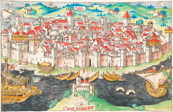
The great city of Zara.
__________________________________________________________________________________
Greetings,

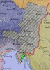
This is a reboot of my first (and, at time of writing, only) timeline. It focuses on the obscure city-state of Zara (modern Zadar, Croatia) which existed during the power struggles between Hungary and Venice in the late 12th-early 13th century. The point of divergence occurs at the beginning of OTL's infamous Fourth Crusade, in the course of which Zara (and, of course, Constantinople) fell to invading enemies. The invasion effectively ended the potential for Zara to operate as a distinct power, and the city was ultimately absorbed into the Republic of Venice.

IOTL the Pope refused to condone the attack on fellow Christians, threatening excommunication to any who participated. However, this information was suppressed by Boniface of Montferrat and Enrico Dandolo, thus persuading the Crusaders to take part.

ITTL, Simon de Montfort (a Crusader leader who refused to involve himself with the attack on Zara) hears about this before the expedition departs Venice for Zara, subsequently revealing the truth to the Army and causing the Crusade itself to collapse. This is the point of divergence.

The timeline was originally inspired by the following two threads:
This timeline is written in British English. If you spot a spelling error, please do inform me, but check it's not a British form before you do so if possible!

As mentioned in this TL's previous incarnation, because this is my first timeline constructive criticism and advice would be gratefully received.

First version of the timeline here (possible spoiler alert).

I had to drop the previous TL because A Levels (the highest compulsory qualifications in the British education system, for those who don't know) and other aspects of real life intruded. But now I have finished, I have a long summer ahead of me, and I intend to do a History degree anyway (so this counts as preparation, right? :p).

There were also a few aspects I was unhappy with - some updates were too short, others were light on detail. I also wanted to improve the overall aesthetic and implement the index system, for ease of navigation. Some plot points also needed changing - for example, I now consider the Fall of Venice depicted in the original to have been an over-optimistic view of what the Dalmatians could achieve, even with Genoese and Pisan aid. Any constructive input on the realism of this TL as we move forward would be appreciated.

I have a few updates backed up for emergencies, and intend to have one out every few days. I'm also going to experiment with other formats (e.g. letters), so let me know what you think of that once we get there.

I would also like to pay tribute to the unsung hero of the first incarnation, @MakiRoc, who greatly assisted me with knowledge of Dalmatian names and the histories of certain key individuals; as well as @Damian0358, the most consistently interested reader of the previous incarnation.

As promised, I hereby mention as many of the readers of the TL who posted more than once as I could find, on the off-chance that some will wish to read the new version:
I will have the first update out tomorrow.

Happy reading!

- Iluvatar
 
Last edited:
Chapter 1 - Beginnings
__________________________________________________________________________________
Boniface-of-Montferrat.jpg

Boniface of Montferrat appointed leader of the 'Crusade of 1202'.
__________________________________________________________________________________
Beginnings
__________________________________________________________________________________​

The failure of the so-called ‘Crusade of 1202’[1] has been the subject of much controversy amongst historians since the thirteenth century. First preached by Pope Innocent III in 1198 in his bull, the Post Miserabile, the target of the Crusade was to be Egypt. Despite reluctance from many of the European monarchies, a crusading army was eventually organised at the tournament of Écry-sur-Aisne.

Most previous Crusades had begun in the Greek[2] capital of Constantinople, and had henceforth fought their way across a hostile Anatolia to reach the Levant and Jerusalem. But by the end of the twelfth century, the centre of Islamic power in the Middle East had shifted to Ayyubid Egypt. In Europe, Crusader interests turned towards striking a blow against the new power, to enable the recovery of Jerusalem. However, an attack on Alexandria, the principle Egyptian port-city, would require naval power. In their need, Boniface of Montferrat (appointed the leader of the Crusade, after the death of Count Thibaut of Champagne) turned to the Venetians to gain assistance, and to furnish the army with transportation to Egypt.

In March 1201 Doge Enrico Dandolo of Venice agreed to Boniface’s request to transport 33’500 soldiers to the Holy Land. Throughout the latter part of 1201 and the earlier months of 1202, the economy of Venice turned itself almost exclusively towards the construction of the fleet. Almost all commerce ceased, and the build-up required between 14’000 and 20’000 men to manage the ships. The result was a Grand Fleet – Armada Grando - of 50 War Galleys and 450 transport vessels. It is difficult to overstate the power of this force; it was considered fully capable of asserting European dominance over the Eastern Mediterranean and landing enough Crusaders in Egypt to achieve their goal.

However, when the Crusaders congregated at Venice in May 1202, they were unable to raise the agreed price for the fleet. Many Crusaders had chosen to sail from other ports, such as Genoa and Marseilles, leaving only 12'000 (around five thousand knights and seven thousand foot-soldiers) to cover the full expense. The Venetians demanded the decided total of 85’000 silver marks, as this was the sum offered by the Crusader envoy Geoffrey of Villehardouin[3] during the negotiations. Only around 50’000 could be raised, and then only by reducing the army to terrible poverty. Even Enrico Dandolo's threats to intern the Crusaders would yield no more money.

The Doge was unable to simply dismiss the Crusade – the expense alone of the preparations required some form of reimbursement, and the prestige of the Republic itself was at stake. As the money could not be raised, Dandolo proposed that the army assist Venice in recovering its former domains along the Dalmatian coast and the peninsular of Istria. In particular Zara, known also as Jadra (in Dalmatian) and Zadar (in Croatian), was coveted by the Doge - the city-state had rebelled against Venetian rule in 1181 and placed itself under the protection of both the King of Hungary and the Papacy. It was a central node of trade, and its conquest would ensure Venice's position as 'Queen of the Adriatic'.

Without any other means of transporting the Crusade, Boniface of Montferrat agreed to the Venetian plan.
__________________________________________________________________________________​

Extract from: Zara: A Study in Dalmatian History
__________________________________________________________________________________​

Footnotes

Firstly I should mention that, with the exception of different terminology, everything that happened in this update was OTL.

[
1]
This is the name given to what was in OTL the Fourth Crusade. As it fails ITTL, the name 'Fourth Crusade' will instead come to be used in reference to a later expedition.

[2] IOTL, western Europeans usually refused to acknowledge the Basileía Rhōmaíōn, the Greek-speaking remnant of the Eastern parts of the Roman Empire, as the legitimate continuation of said empire. Instead, they regarded the Holy Roman Empire as the true inheritor of the imperial title. The term Imperium Graecorum was used as an alternative, meaning 'the Empire of the Greeks'. ITTL, for reasons irrelevant to the story, this name remains the preferred description for the medieval Roman Empire. In return the Romaíoi labelled the Holy Roman Empire the Imperium Francorum.

[3] Geoffrey of Villehardouin later became an historian.
__________________________________________________________________________________​

Here is a political map of the Adriatic region at the beginning of 1202. It is based off several sources, which are listed below:

https://en.wikipedia.org/wiki/Bosni.../File:Medieval_Bosnian_State_Expansion-en.svg
https://en.wikipedia.org/wiki/Dalmatian_city-states#/media/File:Dalmatian_language_map_bgiu.jpg
https://en.wikipedia.org/wiki/Grand...efan_Nemanja_and_Stefan_the_First-Crowned.jpg
https://en.wikipedia.org/wiki/Kaloyan_of_Bulgaria#/media/File:Bulgaria_under_Kaloyan.png

Obviously these are all sourced from Wikipedia (and therefore of potentially dubious reliability), but in turn they are sourced from elsewhere. If there are any glaringly obvious issues please let me know and I can look into changing stuff.

30ufegw.png


The orange polities are not one unified state (yet) - it's just more convenient to depict them all as one colour for clarity. Each Dalmatian city-state is, at present, an 'independent' actor with varying degrees of loyalty to Hungary or Rhōmania.
__________________________________________________________________________________​

Please let me know what you think, I like feedback!

- Iluvatar
 
Last edited:
Interested in seen how the relation between Zara and Hungary turn out. Also how the Byzantines will develop without the fourth crusade
 
Very good start of your reboot. I like that you decided to change the fall of Venice. I agree it was too optimistic and too fast.
The map could use some corrections but that’s my OCD talking (to much green islands, Baranya should be under Hungary proper). Those are minor cosmetic problems that most people won’t care about. Maybe the only thing you can change is maybe split off Slavonia from Croatia into a separate banate. This could be benificial for certain complications that may arise in the Hungarian realm later on.
Keep up the good work
 
I'm so happy to see this back! You will definitely see me following this!

Very good start of your reboot. I like that you decided to change the fall of Venice. I agree it was too optimistic and too fast.
The map could use some corrections but that’s my OCD talking (to much green islands, Baranya should be under Hungary proper). Those are minor cosmetic problems that most people won’t care about. Maybe the only thing you can change is maybe split off Slavonia from Croatia into a separate banate. This could be benificial for certain complications that may arise in the Hungarian realm later on.
Keep up the good work

Great to see you guys back again!

I tried to be as accurate as possible to the various maps of the period I could find (the list above is not exhaustive), but I suppose it was inevitable that some mistakes crept in - partly due to the fact that borders, particularly in that region at that time, were very fluid.

I chose to show Bosnia as a separate Banate because it was de facto independent at the time - in 1203 King Emeric tried to use the Bogmilist heresy as an excuse to reassert true Hungarian suzerainty there. I might be mistaken but I think Croatia was still ruled as one whole by a viceregal ban at the time - I think the split into 'the Whole of Slavonia' and 'Croatia and Dalmatia' came in 1225 IOTL.

Interested in seen how the relation between Zara and Hungary turn out. Also how the Byzantines will develop without the fourth crusade

The relationship will be complex and (hopefully) interesting. It may be something of a paradox as the legitimacy of Zaratin primacy in Dalmatia will stem from the will of the King, but that same King's attempts to integrate the Dalmatians more closely into his realm will be of great irritance to Zara.

Equally the fate of the Romaíoi will be complex, but because of all the Byzantophiles out there (myself included!), I don't want to distract too much from Dalmatia. I will only go into depth where relations between Zara and Constantinople deem it necessary. Hope you'll stick around to find out.
 
Last edited:
I tried to be as accurate as possible to the various maps of the period I could find (the list above is not exhaustive), but I suppose it was inevitable that some mistakes crept in - partly due to the fact that borders, particularly in that region at that time, were very fluid.

Yeah, if there's one thing that always bothers me with maps in this period, it's that whatever sources exist can get rather vague over what period it is depicting, especially when they span a large period and they decide to show battles that have happened, perhaps to show some sort of progression?

If you want, here's two more sources for Serbian borders which I shared last time around - both have the border of Serbia in/after 1190, which is when the Battle of (South) Morava took place (where Isaac II Angelos defeated Stefan Nemanja Zavidović, but decided after the battle to recognize Raška/Serbia's independence), as well as the border during the rule of Nemanja's son, Stefan Nemanja II the First Crowned (though the latter map specifies the borders as formed following Serbia's expansion in 1208, after Kaloyan's death presented an opportunity).

Looking into the battles that the Bulgarian map specifically shows, and checking Bulgarian Wikipedia, it seems that in 1202 Emeric invaded the Bulgarian-owned regions of Belgrade, Braničevo and Niš, the last handing over to Vukan Nemanjić; before Kaloyan counter-invaded in 1203 with Vukan's brother and proper ruler Stefan in tow, taking back the stolen regions, and restoring Stefan to power. So awkwardly enough, it seems that all three Serbian maps (the one you used, and the two I've presented) appear to be set after 1208, after Belgrade and Braničevo had fallen under Hungarian rule once more, during the rule of Boril. They aren't kidding when they are saying that rule of the region changed hands between the Hungarians and Bulgarians frequently!

So, the south and the off-screen south-eastern border are likely at their 1190 borders (whichever version it may be from the three sources we have), but all three sources have different looking borders with Bosnia, like how far up the Drina river they go (though they have some consistent elements, like how the island of Brač acts as a reference to how far the border stretches in the west). Damn thee, cartography for the medieval period of the Balkans!
 
Last edited:
I kinda feel bad about even mentioning the map. However precise you try to be there will always be someone who will be unsatisfied. After all these are the Balkans we are talking about. I just hope the crazies don’t come over and start arguing. Just forget I mentioned the map. Thing are going to end up being different from OTL anyway, so let’s carry on with this magnificent timeline.
 
Ahhh, I'm quite excited to see this back! Loved the original, can't wait to see how this reboot develops~

As for the map, I see some small Istrian states- will they play a small part as they did at the beginning of the timeline's previous version? Or will they be ignored for the moment?
 
The next update will be out later today, just doing final edits.

Yeah, if there's one thing that always bothers me with maps in this period, it's that whatever sources exist can get rather vague over what period it is depicting

Oh, tell me about it. I just try to draw an approximation by looking at as many sources as possible, to get an overall picture. It doesn't help that the Fourth Crusade and the Bulgarian-Hungarian Wars occurred during the period, with Serbia thrown in for good measure, messing up all the borders.

If you want, here's two more sources for Serbian borders which I shared last time around

Thanks, those should be helpful. They also have some degree of consistency between then which may make them somewhat more reliable.

it seems that in 1202 Emeric invaded the Bulgarian-owned regions of Belgrade, Braničevo and Niš, the last handing over to Vukan Nemanjić; before Kaloyan counter-invaded in 1203 with Vukan's brother and proper ruler Stefan in tow, taking back the stolen regions, and restoring Stefan to power. So awkwardly enough, it seems that all three Serbian maps (the one you used, and the two I've presented) appear to be set after 1208, after Belgrade and Braničevo had fallen under Hungarian rule once more, during the rule of Boril. They aren't kidding when they are saying that rule of the region changed hands between the Hungarians and Bulgarians frequently!

Yes, he did. The map above shows the situation at the beginning of 1202, before the Hungarian capture of Belgrade. At present the butterflies haven't spread far enough to affect this conflict, though as you will remember from last time round there are some changes later - though they may play out slightly differently this time.

I kinda feel bad about even mentioning the map. However precise you try to be there will always be someone who will be unsatisfied. After all these are the Balkans we are talking about. I just hope the crazies don’t come over and start arguing. Just forget I mentioned the map. Thing are going to end up being different from OTL anyway, so let’s carry on with this magnificent timeline.

Please don't feel bad! I need to know if there's something inaccurate, otherwise I can't improve it. I think I know where the incorrect Croatian-Hungarian border came from - I traced the map from Google Earth (there was no suitable base map), and I must have followed the Danube too far north.

I had always planned to edit the map once mistakes were noticed, so the adjustments to the Serbian and Croatian borders aren't giving me any extra work, if that's what concerns you :)

Ahhh, I'm quite excited to see this back! Loved the original, can't wait to see how this reboot develops~

Hope you enjoy it!

As for the map, I see some small Istrian states- will they play a small part as they did at the beginning of the timeline's previous version? Or will they be ignored for the moment?

Istria is a conundrum because of various polities vying for power there. These included Venice, the Patria de Friuli (Aquileia), Gorizia, Merania, Carniola, Croatia and the various city communes of the peninsular (Trieste and Pola were the most important). Somewhere in there was the more vaguely termed 'March of Istria' of the Holy Roman Empire. I already think it will have to be altered on the map along with the other fixes because I recently discovered some firmer details about the territory of Merania.

I will go into more depth about Istria this time around, but to start with its role will be basically the same as it was in the first version.
 
The whole map issue can sometimes be resolved by the odd caveat note on maps e.g. "based on the later 15thc century map by [nationality] historian X" etc.
No proper timeline is complete without in-universe arguments over bias and nationalist exaggeration!
 
Chapter 2 - Dissolution
__________________________________________________________________________________
image002.jpg

The Venetian Arsenal, 1202
__________________________________________________________________________________
Dissolution
__________________________________________________________________________________​

The decision of Boniface of Montferrat was a fateful one. In agreeing to attack a Catholic city, Zara, the Crusade was now violating the express wishes of Pope Innocent himself. Boniface, along with the other leaders of the Crusade, had sworn to use their swords against the Saracens alone at the field of Écry-sur-Aisne, an oath specifically requested by the Papacy. This may have been founded in fears that the Crusaders might attack the Empire of the Greeks, as proposed during the Third Crusade by Frederick Barbarossa, Holy Roman Emperor. It also represented Innocent's desire to keep the Crusade under direct Papal control - if the expedition became caught in the web of Latin or Greek politics, power would pass to the secular military leaders and away from the Papal representatives. The Papacy was committed to the conquest of Egypt and the recovery of Jerusalem, and desired no distraction or deviation.

The Papal Legate to the Crusade, Cardinal Peter of Capua, wrote to Innocent to endorse the decision as necessary to avoid to total failure of the expedition. The Pope was unimpressed and concerned by the development, especially as Zara had placed herself under Papal protection after her rebellion against Venice in 1181[1]. Attempting to dissuade them from the scheme, he wrote to the Crusader leaders and Doge Enrico Dandolo, threatening excommunication in retaliation for any attack on Zara.

It was here that the Crusade was undone. Boniface and Dandolo attempted to suppress the news of the excommunication threat, but Simon de Monfort, one of the Crusader leaders, learnt of the letter and revealed its contents to the army[2]. There was uproar and fear at the prospect of excommunication among the Crusaders, causing a total collapse of order on Lido, the island on which the army was encamped. Many deserted immediately, others demanded that the army proceed at once to the Christian holdouts at Tripoli and Acre. De Montfort departed at once, returning to his fief in France with his knights. The violence on Lido caused the Papal Legate to seek refuge at Saint Mark’s Basilica in Venice, and Boniface of Montferrat to join the Doge at his court. Without authority, the army dissolved itself and dispersed to the mainland. The so-called ‘Crusade of 1202’ was over.

The impact was widespread and varied. In Zara, where news of the proposed attack arrived in late September, there was general relief and rejoicing, as well as an anti-Venetian backlash. The Zaratin[3] Comes[4] Antonio Begna[5] expelled all Venetian merchants from Zara on the 27th of September, their property impounded. There was little fear of retaliation because Zaratin trade was routed through Ancona and on to Florence, rather than to the Venetian lagoon. In the other cities of the Dalmatian littoral there was also relief - the signorias, comites[6] and rectors were under no illusion that they were as much a Venetian target as the chief city of their region.

Elsewhere, reactions were more mixed. In Venice itself, the collapse of the Crusade presented the government and the Doge with the problem of deciding what to do with the Grand Fleet, into which so much time and so many resources had been invested. This issue has been called 'Dandolo's Great Matter' by historians. At the Vatican, Pope Innocent was relieved that there had been no Catholic fratricide, but began to wonder whether the price - the failure of the Crusade - had been too high. As usual, the Greek Emperor in Constantinople, Alexios III Angelos, was too incompetent to keep up with the intricacies of foreign policy. In any case, the ultimate result of any Latin assault upon Ayyubid Egypt would not have any great impact on the ongoing Greco-Turkic Wars.

__________________________________________________________________________________​

Extract from: The Histories of the Lesser Crusades
__________________________________________________________________________________​

Footnotes:

[1]
This happened IOTL.
[2] This is the POD.
[3] 'Zaratin' is the demonym for an inhabitant of Zara.
[4] Comes is a Latin noble title roughly equivalent to 'count' or 'earl'. It was common among the city-states and communes of Italy and Dalmatia, alongside signorias, doges, doux and rectors.
[5] Antonio Begna is a fictional character. Records are unclear as to the identity of the Comes of Zara at this time, so I had to invent one. Damiano Desinie was Comes until his death in 1199, and the Croat nobleman Domald of Sidraga (possibly of the family of Kačić, which dominated the hinterland of Zara at the time) was elected to the office by the exiled Zaratins in 1202 (in fact he successfully liberated the city). The time between, I could find nothing for.
[6] This is the plural form of Comes.
__________________________________________________________________________________​

Feedback wanted and welcome!

- Iluvatar
 
Last edited:
Here is an edited map of the situation at the beginning of 1202. I took into account some proposed corrections, which has hopefully improved the accuracy. I left the Serbian islands as they were, however, because having looked into their history a little it seems that they were de facto independent microstates with varying and fluctuating degrees of loyalty to Venice, Ragusa, Serbia and Rhōmania. If there are any further possible improvements please don't hesitate to inform me, whether by PM or in thread!

w0t0ns.png
 
I left the Serbian islands as they were, however, because having looked into their history a little it seems that they were de facto independent microstates with varying and fluctuating degrees of loyalty to Venice, Ragusa, Serbia and Rhōmania. If there are any further possible improvements please don't hesitate to inform me, whether by PM or in thread!
I think only Korčula and Mljet could stay green. Even that is debatable for the reasons you mentioned. You can see in the maps provided by Damian0358 the extent of Serbian de jure control on the Adriatic. I think you should use that as a reference.
I have never heard that the Serbian realm held Brač, Hvar, Vis, Šolta...etc. Never. Only problem is should the islands go to Croatia/Hungary (de jure control) or maybe count them as Dalmatian communes (de facto independent, Latin official language, Roman law, but I’m not sure about how Latin the population really is in the early 13 century). If you group them as Dalmatian communes then you obviously have to throw in Korčula and Mljet just to be consistent (and use their romance names not the modern Slavic variants). I think it would be officially more correct to paint them light brown.
I wonder why you chopped out the whole area around Rijeka/Fiume and painted it gray. The city itself had some autonomy but I don’t think they controlled that whole area (which roughly is the modern district of which Rijeka is the administrative center). Only the city should be colored gray, everything else should be light brown.

I also wonder what should be done about Šibenik aka Sebenico? Historians count this as a Dalmatian commune but is founded by the Croats. It’s Croat population culturally latinised (Not in language but in customs & law) up to the beginning of this POD, and has gained autonomy just like the other real Dalmatian cites. When the Dalmatians acted together then Šibenik was always involved as an equal member. Do you think Šibenik should be grouped with the Dalmatians or is it better to keep them with Croatia/Hungary?
 
I really like the fact that even though the obvious subject of an averted fourth crusade POD would be the fate of the Byzantine empire, you choose to focus on a different and much more obscure Dalmatian city state. I'm hooked :D

Also, you're using a very nice layout for your updates, but maybe consider changing the colouring of the foot-notes to something other than red? It stands out a tad too much IMHO.

Plus a nitpick, wasn't Alexios Angelos the III and not the II?
 
Seems like an interesting TL; medieval politics are always fascinating. Followed!

Thanks, hope you enjoy what's to come!

I think only Korčula and Mljet could stay green. Even that is debatable for the reasons you mentioned. You can see in the maps provided by Damian0358 the extent of Serbian de jure control on the Adriatic. I think you should use that as a reference.
I have never heard that the Serbian realm held Brač, Hvar, Vis, Šolta...etc. Never. Only problem is should the islands go to Croatia/Hungary (de jure control) or maybe count them as Dalmatian communes (de facto independent, Latin official language, Roman law, but I’m not sure about how Latin the population really is in the early 13 century). If you group them as Dalmatian communes then you obviously have to throw in Korčula and Mljet just to be consistent (and use their romance names not the modern Slavic variants). I think it would be officially more correct to paint them light brown.

Ah, I see where I got that mixed up. Certainly Korčula and Mljet were to some extent beholden to Serbia, but those further from the shore I initially painted green because the base map I used at first (listed above the first version of the TL's map in the first update) had both Serbia and those islands in white, though I now notice a dotted line separating them. I think I'd better change that!

I think the best solution would be to leave them grey for now, to represent their lesser power compared to the more important Dalmatian municipalities. In time, however, they will most probably be absorbed by Ragusa, Spalatro or Tragura as culturally Dalmatian. While they might in truth have been under the Hungarian-Croatian crown, direct control from Buda seems perhaps more theoretical than material.

I wonder why you chopped out the whole area around Rijeka/Fiume and painted it gray. The city itself had some autonomy but I don’t think they controlled that whole area (which roughly is the modern district of which Rijeka is the administrative center). Only the city should be colored gray, everything else should be light brown.

It is supposed to represent the Duchy of Merania, part of the Holy Roman Empire. I was researching the situation of Istria during this period - obviously quite important due to its proximity to Dalmatia - and noticed that an entity of this name existed at this time, adjacent to the Kvarner Gulf and including Rijeka/Fiume/Floim. In fact the writer of Historia de Expeditione Friderici Imperatoris (The story of Emperor Frederick Barbarossa's crusade) mentions the ruler of the fief as 'the Duke of Dalmatia, also called Croatia or Merania', indicating that its territory was situated somewhere in traditional 'Croatia' and at least on the fringes of what can reasonably be called 'Dalmatia'. The similarity to the modern Primorje-Gorski Kotar County is entirely coincidental!

I also wonder what should be done about Šibenik aka Sebenico? Historians count this as a Dalmatian commune but is founded by the Croats. It’s Croat population culturally latinised (Not in language but in customs & law) up to the beginning of this POD, and has gained autonomy just like the other real Dalmatian cites. When the Dalmatians acted together then Šibenik was always involved as an equal member. Do you think Šibenik should be grouped with the Dalmatians or is it better to keep them with Croatia/Hungary?

I think I'll leave it within Croatia for now, as it did speak Croatian and it was granted the status of a town directly by the King of Hungary in 1167, rather than having its municipal status recognised as a matter of fact when Hungary gained control over Croatia, as the eight traditional Dalmatian cities did. As Zara's influence grows, however, and Dalmatia begins to coalesce into a more cohesive whole, it's likely that Sibenico will ultimately be absorbed. Wait and see :)

I really like the fact that even though the obvious subject of an averted fourth crusade POD would be the fate of the Byzantine empire, you choose to focus on a different and much more obscure Dalmatian city state. I'm hooked :D

Thanks. Dalmatian history and politics is really interesting so I was quite keen to explore it once I found out about it. Obviously the fate of Byzantium will crop up, but I will try to keep the focus on Zara to avoid making this a Byzantine timeline.

Speculation on Byzantium's fate in the thread would be welcome, by the way. I have a general idea of what I want to to with it, but thoughts on what would be necessary to pull the Empire out of its quagmire would be constructive.

Also, you're using a very nice layout for your updates, but maybe consider changing the colouring of the foot-notes to something other than red? It stands out a tad too much IMHO.

I suppose it does, yes. I used red because I'm endlessly losing my place in TLs when I'm flicking back-and-forth between text and foot-notes. I might experiment with blue.

EDIT: I changed it to salmon, which is rather more subtle. Blue and green weren't really noticeable enough. Thoughts?

Plus a nitpick, wasn't Alexios Angelos the III and not the II?

Yes, thank you, that was a typo :p
 
Last edited:
It is supposed to represent the Duchy of Merania, part of the Holy Roman Empire. I was researching the situation of Istria during this period - obviously quite important due to its proximity to Dalmatia - and noticed that an entity of this name existed at this time, adjacent to the Kvarner Gulf and including Rijeka/Fiume/Floim. In fact the writer of Historia de Expeditione Friderici Imperatoris (The story of Emperor Frederick Barbarossa's crusade) mentions the ruler of the fief as 'the Duke of Dalmatia, also called Croatia or Merania', indicating that its territory was situated somewhere in traditional 'Croatia' and at least on the fringes of what can reasonably be called 'Dalmatia'. The similarity to the modern Primorje-Gorski Kotar County is entirely coincidental!

Ok, I understand now. I must confess my knowledge of Istrian medieval history is poor and I had to look it up. Tried to find a map of the Duchy of Merania on the internet but came up with nothing. The Croatian Wikipedia entry mentions that it's geographic position is on the other (western) side of the Kvarner bay from Rijeka to Plomin. This still fits the presumption that the area is in Dalmatia/Croatia since it was part of Roman Dalmatia and since the terms Dalmatia and Croatia are sometimes (wrongly) used interchangeably. I drew a map and colored what presumably Merania is green. I hope I'm not wrong.
 

Attachments

  • Merania.jpg
    Merania.jpg
    77.5 KB · Views: 745
...maybe consider changing the colouring of the foot-notes to something other than red? It stands out a tad too much IMHO....

OTOH, it is absolutely brilliant of you to use a color that does stand out. I can't tell you how often I squint and strain to hunt down the referent of some fascinating footnote, particularly "this is the POD!" Colorizing them worked wonderfully well for me, and I suspect I am praising the very color choice Milites dislikes. I very much liked that they stood out like neon signs--I'd much rather squint to read what number it is (especially since mere sequence leads me to the right region of the text) than go on an Easter Egg hunt, which too often turns into a snipe hunt, for a particular subtly placed notice.

@Milites, may I suggest you put up some sample text with examples of colors you would find more tasteful deployed as highlights of one or two characters after a small block of text, so the author may judge which of your preferences would work best, rather than just put the burden entirely on Iluvatar?

--Oh, wait, I replied before reading the author's own reply. Yes, the salmon works very well for me! TBH, I myself might prefer red, since the footnote numbers are indeed a bit hard to read without some squinting! But if Milites and others who might have found the red too garish (I was going to propose thinking of it as being like those giant illuminated first letters typical of medieval manuscripts) like the smoother flow of scanning over the salmon letters, as I said I am fine with the note numbers being a bit obscure because their first purpose is to be easy to be found, and the wonderful "shines like neon" experience I mentioned was precisely with the salmon letters. Perhaps red would have been bad, whereas I think you are quite correct that blue would blend in too well. It is really sweet of you to choose some alternate formatting to make the notes stand out, and the purpose of that extra effort would be lost if they then blended. Salmon is discreet enough to be skimmed over painlessly and yet make an obvious target when back-reading.

If anyone else has a better suggestion, I urge my advice on them above--show us all some samples. Share in the effort a little!

And everyone could bear in mind that different browser and site theme choices have different outcomes.

Anyway your extraordinary effort in this formatting matter is greatly appreciated by me!
 
Top