You are using an out of date browser. It may not display this or other websites correctly.
You should upgrade or use an alternative browser.
You should upgrade or use an alternative browser.
County-BAM
- Thread starter Chicxulub
- Start date
JJohnson
Banned
Brilliant work. It will be very useful for many future projects I feel.
Agreed. This is amazing work.
Not to pile on your plate, but would it be possible to have a Mexico and Canada County map in the same scale? That'd be great for Alt-Hist Maps of varying states like an Ottawa (Ontario Peninsula) or Rio Grande, etc. Perhaps a historic (19th century) Great Britain counties? The old 39 counties of England and so on would be nice to see again in the same scale, and maybe the German Empire also.
Alex Richards
Donor
Agreed. This is amazing work.
Not to pile on your plate, but would it be possible to have a Mexico and Canada County map in the same scale? That'd be great for Alt-Hist Maps of varying states like an Ottawa (Ontario Peninsula) or Rio Grande, etc. Perhaps a historic (19th century) Great Britain counties? The old 39 counties of England and so on would be nice to see again in the same scale, and maybe the German Empire also.
There's already some maps for the old English counties floating about the place, though not on the same scale (and frankly that's not likely to be all that useful anyway). I'll see if I can find a link when I get home.
Final County map
Chicxulub
Banned
Here's a minor update to the County-BAM, I fixed a few areas where I forgot to fill in the water, and I added the border between Currituck and Dare counties in North Carolina.

And here's a modified version with lighter county borders, which I think looks better.

And here's a modified version with lighter county borders, which I think looks better.
Last edited:
I think it be cooler if you did timelines of counties. I found a site that shows this. http://www.historykat.com/artifact/census.html
I prefer http://www.mapofus.org/virginia/I think it be cooler if you did timelines of counties. I found a site that shows this. http://www.historykat.com/artifact/census.html
JJohnson
Banned
I like this county map. With a few alterations it would be a good base for an alternate US with Rio Grande, Baja California (split California along that straight line county), Arizona's coast, Nova Scotia, Columbia (49° to 52° N of British Columbia), Ottawa (Ontario Peninsula) (and other Canadian/American states), Virgin Islands (US+UK), Bahamas, Bermuda, American Polynesia, etc.Here's a minor update to the County-BAM, I fixed a few areas where I forgot to fill in the water, and I added the border between Currituck and Dare counties in North Carolina.
And here's a modified version with lighter county borders, which I think looks better.
I have an announcement to make. I am restarting the County-BAM, this time I'm basing it off the 2015 county wall map from the Census Bureau website. The new County-BAM will be 80% larger, and will have cleaner and more accurate borders and coastlines.
MY BODY IS READY
Chicxulub
Banned
Here is my current progress, which should give an idea of how large it will be.MY BODY IS READY
At this size, we could make a reasonable town map of the US.
Far from every state has uniform towns, and the ones that don't generally have completely insane municipal borders. Have a good look at South Carolina or Alabama in OSM at some point and you'll see what I mean.
Far from every state has uniform towns, and the ones that don't generally have completely insane municipal borders. Have a good look at South Carolina or Alabama in OSM at some point and you'll see what I mean.

...I think I see your point.
At least New York has nice town lines. If you ignore the villages, it could be mapped out pretty easily.
_-_Towns,_Villages,_and_City.svg/350px-Monroe_County_(New_York)_-_Towns,_Villages,_and_City.svg.png)
Chicxulub
Banned
However, for an example, Alabama has County Civil Divisions, which are a rough equivalent to the Minor Civil Divisions seen throughout the Midwest and Northeast.Far from every state has uniform towns, and the ones that don't generally have completely insane municipal borders. Have a good look at South Carolina or Alabama in OSM at some point and you'll see what I mean.
At least New York has nice town lines. If you ignore the villages, it could be mapped out pretty easily.
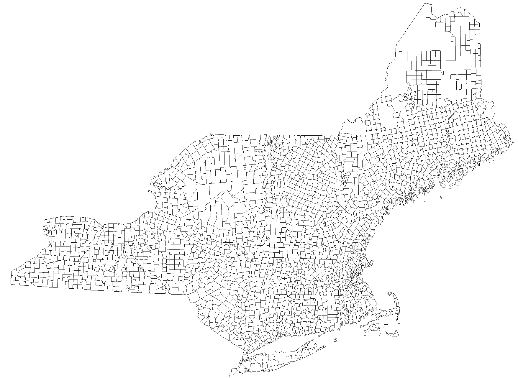
The now-banned VT45 did a map of New England and New York by town a few years ago. I think we can all agree it's pretty fantastic:
Chicxulub
Banned
And Daily Kos had one for the 2012 election that included Pennsylvania and New Jersey.The now-banned VT45 did a map of New England and New York by town a few years ago.
Share: