I don't know if this idea is already taken. If so please link me to it and delete this tread. Most maps we look at are clearly understood. Some might need further context to understand. Then there are some maps that are just confusing. Why was this made? What is the context? This is the thread for that.

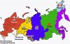
This is one of those maps. I found this while searching up maps of Siberia late at night for a project. It's supposed to be one of those "what if x country balkanized" maps, but this one is very confusing. We got a rump Russia in the east, with Siberia being split between India, Armenia, America, China, Japan, and Canada? The blank sections I assume to be countries that gain independence in this very strange scenario. Is this a shitpost? Is it serious? What is going on here?
This is one of those maps. I found this while searching up maps of Siberia late at night for a project. It's supposed to be one of those "what if x country balkanized" maps, but this one is very confusing. We got a rump Russia in the east, with Siberia being split between India, Armenia, America, China, Japan, and Canada? The blank sections I assume to be countries that gain independence in this very strange scenario. Is this a shitpost? Is it serious? What is going on here?