You are using an out of date browser. It may not display this or other websites correctly.
You should upgrade or use an alternative browser.
You should upgrade or use an alternative browser.


Kano Emirate and neighbors 1850

Katagum Emirate and neighbors 19th century


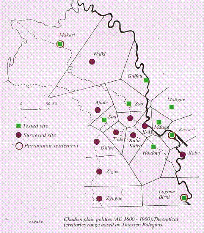
Kotoko Kingdoms in the 19th Century


Ethnic groups of Ghana 1968


all European forts in modern day Ghana (used date a treaty was put into effect rather than when it was signed)
Last edited:
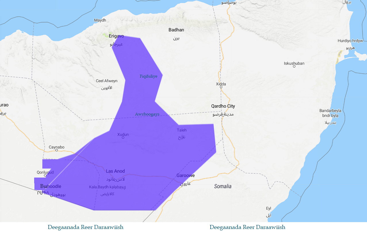
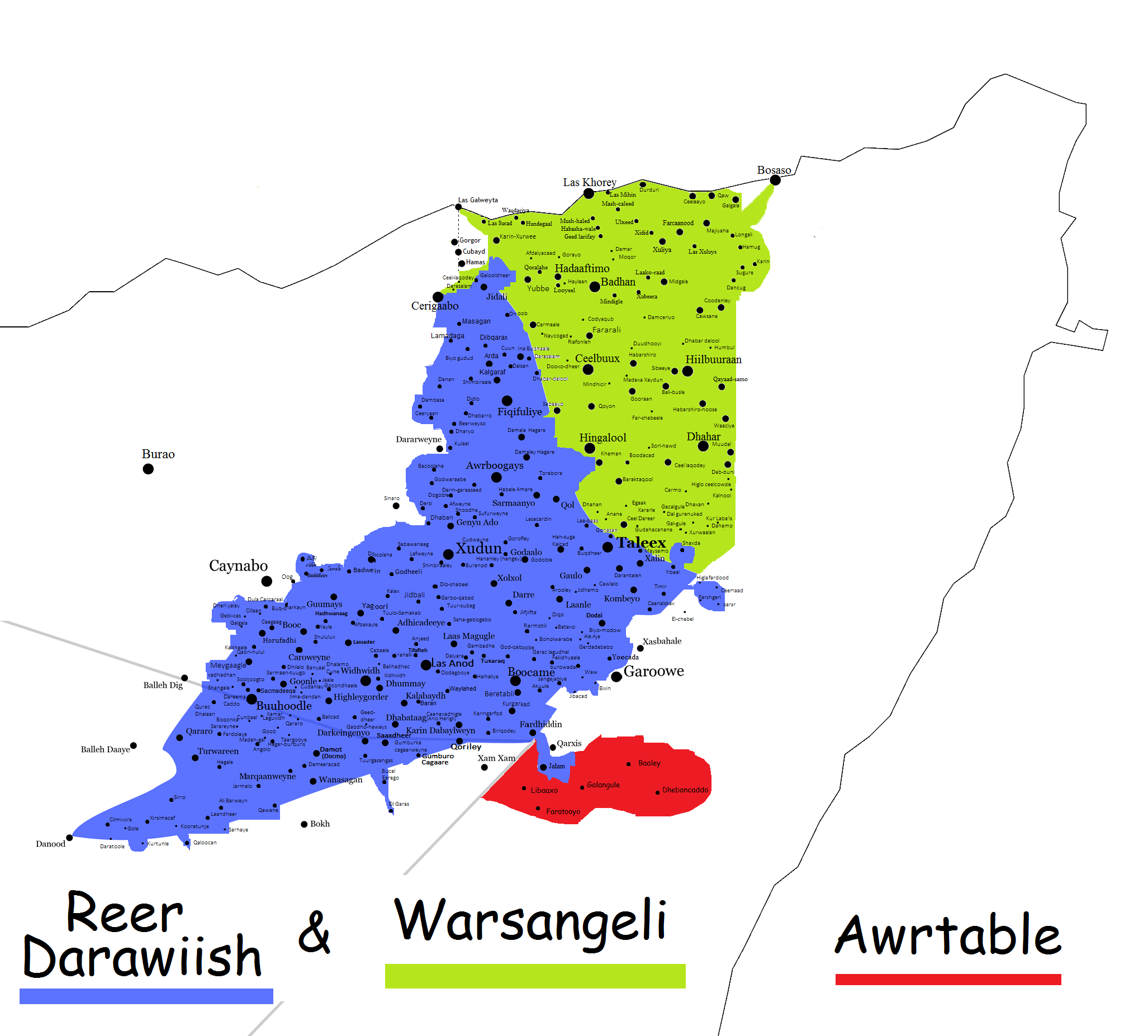
Propose Map of Ghana after Referendum
 https://eprints.soas.ac.uk/31255/1/Rodney_History_Upper_Guinea_Coast.pdf
http://worldafropedia.com/wiki/index.php?title=Adinkra_Symbols
Index.php
https://cdn.discordapp.com/attachme...oire_maritime_africaine_est-elle_possible.pdf
https://cdn.discordapp.com/attachme...A_HISTORY_OF_THE_LOWER_GUINEA_COAST_1460-.pdf
https://surface.syr.edu/cgi/viewcontent.cgi?article=1100&context=ant_etd
https://cdn.discordapp.com/attachme...wer_Fal_m_River_Senegambia_c_AD_1500_1925.pdf
https://www.researchgate.net/public...Resource_Conservation_and_Management_in_Ghana Exploring the African Traditional Belief Systems in Natural Resource Conservation and Management in Ghana
Cosmology_and_Symbolism_on_the_Central_Guinea_Coast.pdf
2.68 MB
Benue-Congo Languages

Borno Salt Mines in 1880

Sources of Salt in the Chad Basin, around the Sokoto era.


The Kong Empire
 https://www.cambridge.org/core/jour...7-plates-map/9748D9BC5B102FA45AA291EEDBEC2952
Cambridge Core
Geschichte von Zamfara, Sokoto-Provinz, Nordnigeria. By Kurt Kriege...
Geschichte von Zamfara, Sokoto-Provinz, Nordnigeria. By Kurt Krieger. (Baessler-Archiv, Beiträge zur Völkerkunde, Neue Folge, Beiheft 1.) Berlin: Dietrich Reimer, 1959. Pp. 147, plates, map. - Volume 30 Issue 3
Gur Languages

Map of Samory's empire in 1888 (first phase)

The expansion of Samory's empire in the first phase
 Link for those maps: https://brill.com/view/book/9789004424876/BP000006.xml
Map showing each phase of Samory's empire

Territorial evolution of Samory's empire

A book about Samory/Samori Ture: https://person.hypotheses.org/files/2013/05/PERSON-SAMORY-JEUNE-AFRI.pdf
Map of changes in the border claims of liberia

Kamerun and Togoland

https://www.loc.gov/resource/g8881e.lm000007/?r=-0.096,-0.045,1.276,0.784,0 Map of liberia from the 1830s
The Library of Congress
Map of Liberia, West Africa.
Relief shown by hachures. Shows boundary of tribes, mission stations, colonist towns, and native towns. Gift; 1968; American Colonization Society; Available also through the Library of Congress Web site as a raster image. Vault

Revolts within the Wassoulou empire c. 1888 https://person.hypotheses.org/files/2013/05/Personcarte21++.pdf
Moose kingdoms

Chiefdoms of Gwendegue in center west Burkina in mid 19th century

http://worldafropedia.com/wiki/index.php?title=Adinkra_Symbols
Index.php
https://cdn.discordapp.com/attachme...oire_maritime_africaine_est-elle_possible.pdf
https://cdn.discordapp.com/attachme...A_HISTORY_OF_THE_LOWER_GUINEA_COAST_1460-.pdf
https://surface.syr.edu/cgi/viewcontent.cgi?article=1100&context=ant_etd
https://cdn.discordapp.com/attachme...wer_Fal_m_River_Senegambia_c_AD_1500_1925.pdf
https://www.researchgate.net/public...Resource_Conservation_and_Management_in_Ghana Exploring the African Traditional Belief Systems in Natural Resource Conservation and Management in Ghana
Cosmology_and_Symbolism_on_the_Central_Guinea_Coast.pdf
2.68 MB
Benue-Congo Languages
Borno Salt Mines in 1880
Sources of Salt in the Chad Basin, around the Sokoto era.
The Kong Empire
Cambridge Core
Geschichte von Zamfara, Sokoto-Provinz, Nordnigeria. By Kurt Kriege...
Geschichte von Zamfara, Sokoto-Provinz, Nordnigeria. By Kurt Krieger. (Baessler-Archiv, Beiträge zur Völkerkunde, Neue Folge, Beiheft 1.) Berlin: Dietrich Reimer, 1959. Pp. 147, plates, map. - Volume 30 Issue 3
Gur Languages
Map of Samory's empire in 1888 (first phase)
The expansion of Samory's empire in the first phase
Map showing each phase of Samory's empire
Territorial evolution of Samory's empire
A book about Samory/Samori Ture: https://person.hypotheses.org/files/2013/05/PERSON-SAMORY-JEUNE-AFRI.pdf
Map of changes in the border claims of liberia
Kamerun and Togoland
https://www.loc.gov/resource/g8881e.lm000007/?r=-0.096,-0.045,1.276,0.784,0 Map of liberia from the 1830s
The Library of Congress
Map of Liberia, West Africa.
Relief shown by hachures. Shows boundary of tribes, mission stations, colonist towns, and native towns. Gift; 1968; American Colonization Society; Available also through the Library of Congress Web site as a raster image. Vault
Revolts within the Wassoulou empire c. 1888 https://person.hypotheses.org/files/2013/05/Personcarte21++.pdf
Moose kingdoms
Chiefdoms of Gwendegue in center west Burkina in mid 19th century
Last edited:
South western Burkina in 19th century

Kasena country in Burkina/Ghana

Puguri clans

Conquest of Burkina

Administrative Borders of niger


Kong kingdom 1750

Kong empire 1750 too

Kola trade routes

1890s Ivory coast, with wassoulou expansion

Ghanaian gold production and trade 18th century

Settlement areas and ethnic groups of Cote'd Ivore

Ijaw/Ijo/Izon clans on the niger delta


 and an older single map depicting Ijaw/Ijo/Izon clans on the niger delta
 Note on the first map: im not sure on its accuracy. i've only found it discussed on this forum site (link below) where most people seem to be ridiculing it https://www.nairaland.com/6796018/breaking-leaked-map-ijaw-republic
Kasena country in Burkina/Ghana
Puguri clans
Conquest of Burkina
Administrative Borders of niger
Kong kingdom 1750
Kong empire 1750 too
Kola trade routes
1890s Ivory coast, with wassoulou expansion
Ghanaian gold production and trade 18th century
Settlement areas and ethnic groups of Cote'd Ivore
Ijaw/Ijo/Izon clans on the niger delta
Last edited:
Kingdom of Porto novo, 1892

Burkina 1850

Booboola 1890

Yoruba kingdoms

lake chad's Kotoko city states

Map of the [Igbo] (blue) and Ibibio-speaking (green) peoples of south-eastern Nigeria

Asaba Hinterland Showing Centres of Ekumeku Activities

https://www.ngomedzap.cm/wp-content/uploads/2020/11/chefferies-traditionnelles-Cameroun.pdf
list of chiefdoms (chefferies) of the modern cameroon administrative system
Burkina 1850
Booboola 1890
Yoruba kingdoms
lake chad's Kotoko city states
Map of the [Igbo] (blue) and Ibibio-speaking (green) peoples of south-eastern Nigeria
Asaba Hinterland Showing Centres of Ekumeku Activities
https://www.ngomedzap.cm/wp-content/uploads/2020/11/chefferies-traditionnelles-Cameroun.pdf
list of chiefdoms (chefferies) of the modern cameroon administrative system
Last edited:
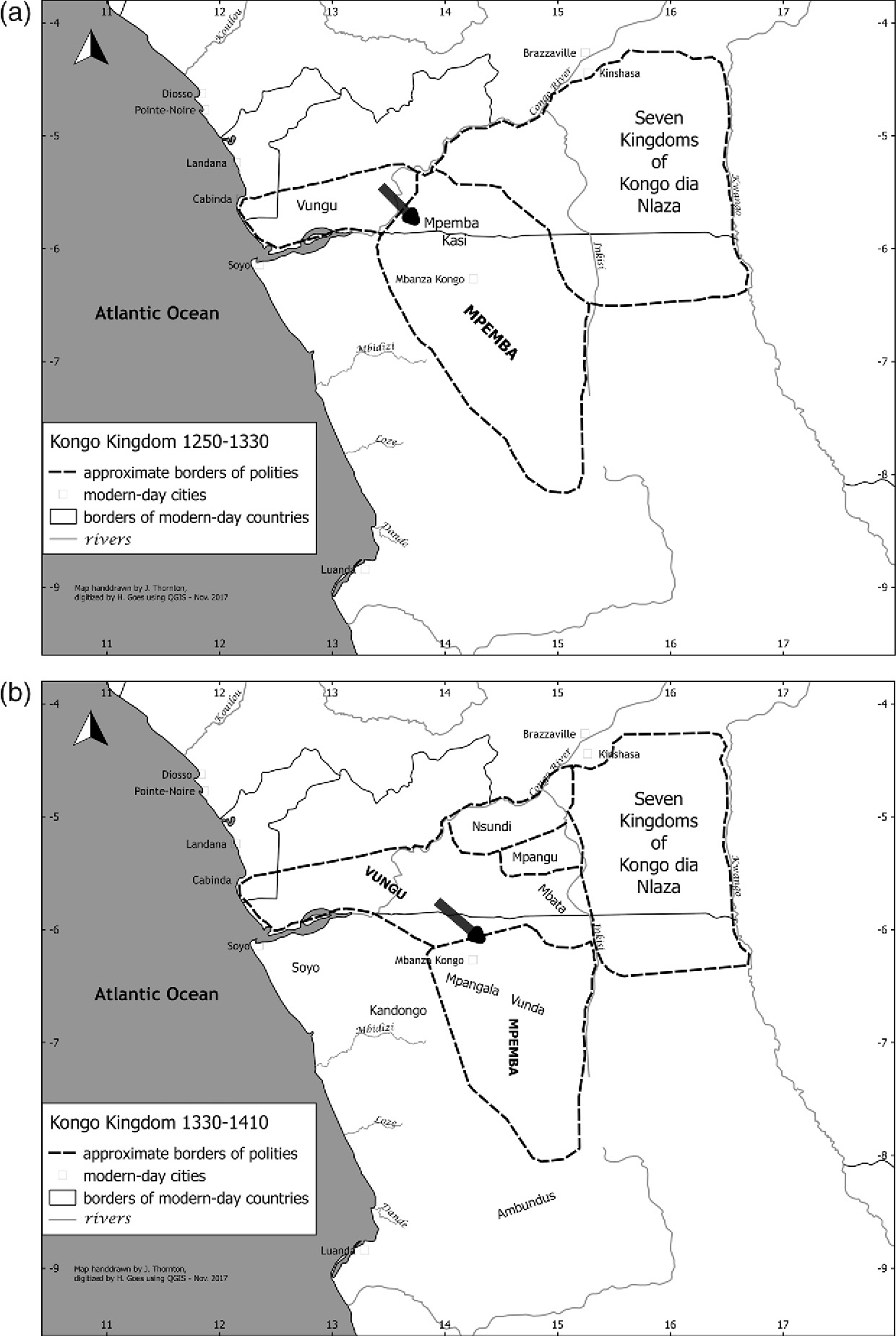
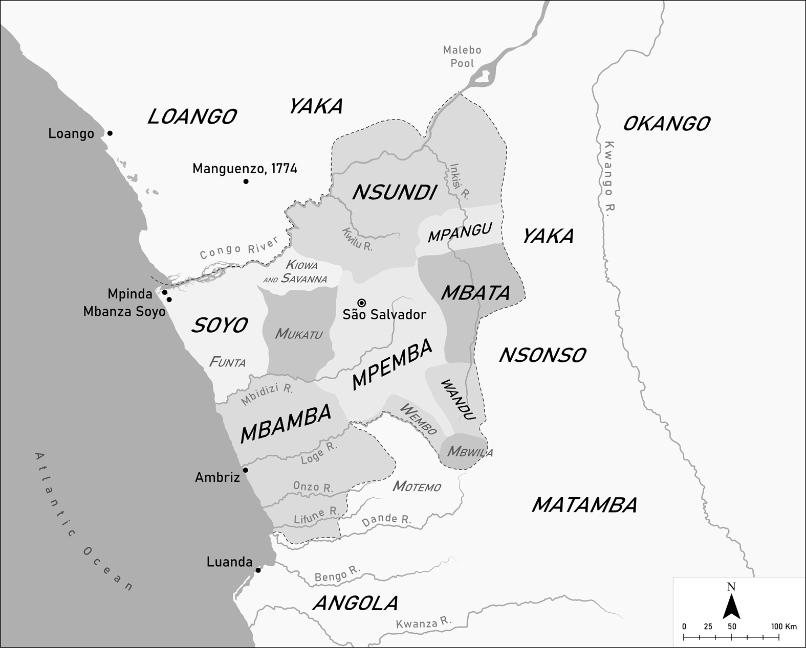
Kongo Kingdom 1250 - 1330 and in 1330 - 1410
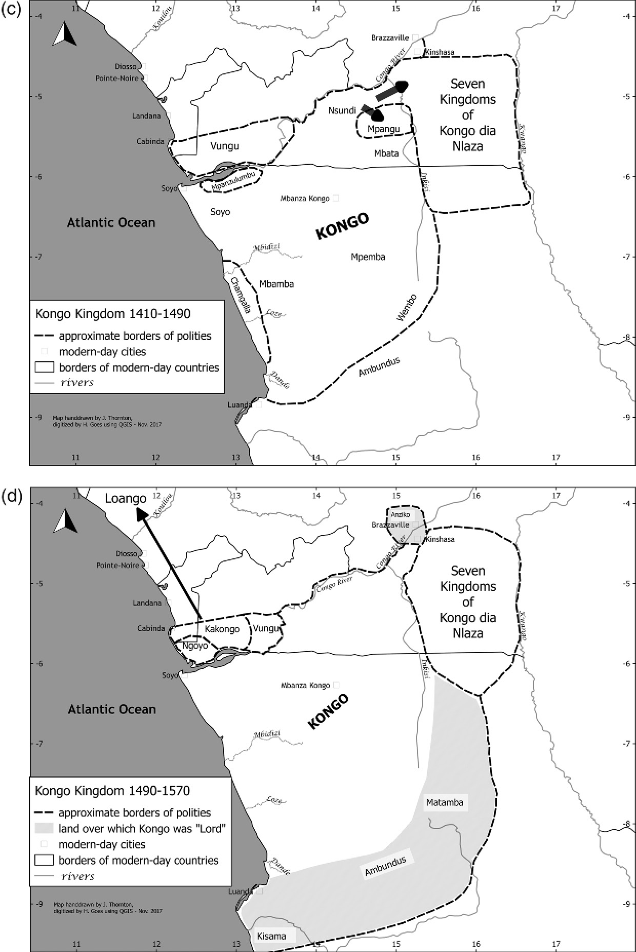
Kongo Kingdom 1410 - 1490 and in 1490 - 1570
I am going to eventually use these to make early Kongo Patches.
Kongo Kingdom 1410 - 1490 and in 1490 - 1570
I am going to eventually use these to make early Kongo Patches.
Last edited:
Kongo around when the Portuguese find them
Kongo archeological sites
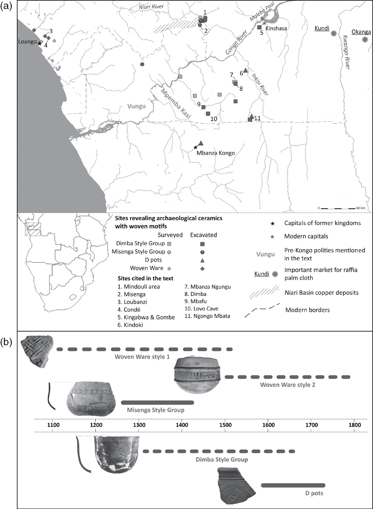
Kongo archeological sites
Last edited:
Reverse Google search says January 1, 1855What year is this of?
Thank you!Reverse Google search says January 1, 1855
Crazy Boris
Banned
I'm pretty sure that some of it is wrong.
A lot of it does look questionable, like the modern border for Spanish Guinea, and whatever the hell is happening with Yemen and Ethiopia
The angular borders and total lack of lakes is also really throwing me off
Lake Victoria is a big thing not to show.A lot of it does look questionable, like the modern border for Spanish Guinea, and whatever the hell is happening with Yemen and Ethiopia
The angular borders and total lack of lakes is also really throwing me off
The Archaeology of Nunge Site: An Ancient Salt Making Settlement and Trading Centre in Bagamoyo, Tanzania

2. Map of Watamu area, showing position of Gede near Mida Creek.

3. Map of Kilwa archipelago, showing position of Songo Mnara ruins.

1. Map of the East African coast, showing locations of Gede and Songo Mnara.

Last edited:


Liberia 1864
 "Cumulatively referred to as Kuba, the people in fact comprise unique independent chieftains. Though culturally and linguistically similar, each is an entity to itself. Joseph Cornets tribal map (above) was published in Art Royal Kuba - page 15. It details political groupings aligned to the Bushoong."


Wolof Kingdoms in the 18th Century
 Dafur Sultanate and its neighbours 1885

West African States 1800


West Cameroon Tribes

Igbo speaking people and their neighbours
 Bamileke country the territorial division

Liberia in the 19th century
https://www.loc.gov/resource/g8881e.lm000007/?r=-0.096,-0.045,1.276,0.784,0 Map of liberia from the 1830s


Yoruba-Aja Country showing the old Oyo empire (Early 19th Century) Source: General History of Africa , VI: Africa in the nineteenth century.
Wolof Kingdoms in the 18th Century

Mali, Songhai, Kanem and Ife
West African States 1800
West Cameroon Tribes
Igbo speaking people and their neighbours
Liberia in the 19th century
https://www.loc.gov/resource/g8881e.lm000007/?r=-0.096,-0.045,1.276,0.784,0 Map of liberia from the 1830s
Last edited:
- https://eprints.soas.ac.uk/29105/1/10731200.pdf
- https://core.ac.uk/download/pdf/11984624.pdf
- https://cdn.discordapp.com/attachme...n_Ethiopian_History_The_Case_of_the_Gafat.pdf
- https://www.janestudies.org/wp-content/uploads/2018/files/NES_no12(2008)_Ishikawa.pdf
- https://www.dropbox.com/s/2wubl6e4qwipybf/melaku_phd_arts_2019.pdf?dl=0
Dropbox
melaku_phd_arts_2019.pdf
Shared with Dropbox - https://www.persee.fr/doc/ethio_0066-2127_2001_num_17_1_995


- https://discovery.ucl.ac.uk/id/eprint/1317929/1/302018.pdf The Social Structure of Southern Somali Tribes
https://docs.google.com/document/d/1yYFPN41U71TQLzO970te4k3Bzd-QCZkG3HlWSi7Azg4/edit source list for the horn of africaGoogle Docs
A Source List for the Horn of Africa
Hello! This is the source list for the Horn of Africa that I have collected for Eu4’s timeframe (and a little beyond) =D. Some sources are heavily used while others are more used for little bits of info. I’ll first go through hard copies of books and then go through online sources. Finally, there...
- massive
- many texts
- (the lengths people go for eu4 holy shit)
Map of Ethiopia in 1300 CE


Internet Archive
Ethiopia, the era of the princes : the challenge of Islam and re-un...
xxvi, 208 pages 23 cm
- Book about somali history https://shcas.shnu.edu.cn/_upload/a...d4e2/7b2a673e-fa6e-4c1b-835d-2eb34c65098e.pdf
- Book about swahili coast in the 1700s and 1800s https://www.researchgate.net/public...Nineteenth_Century_Omani_Forts_in_East_Africa
{{ metaDescription }}
- eritrean tribes
Pre-Derg Language map of Ethiopia and Erytrea


Conquest of Italian Somaliland
- (source maps)


Menelik Campaign- Before the campaign, in 1850

- (1879-1889)

- (1889-1896)

- 1897-1904

Last edited:
Share: