Herder Warfare in East Africa: A Social and Spatial History (Oba Gufu, 2018)What happened that they lost so much coastline to the Somalis?
You are using an out of date browser. It may not display this or other websites correctly.
You should upgrade or use an alternative browser.
You should upgrade or use an alternative browser.

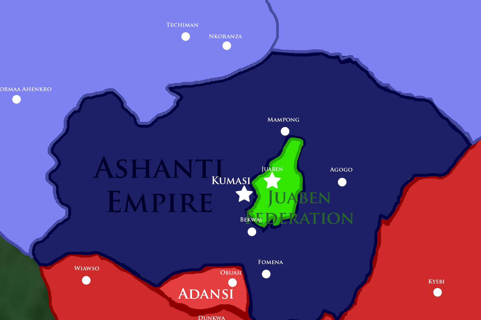
Ashanti kingdom in 1886

Map of Ghana after the crushing of the Juaben Revolt
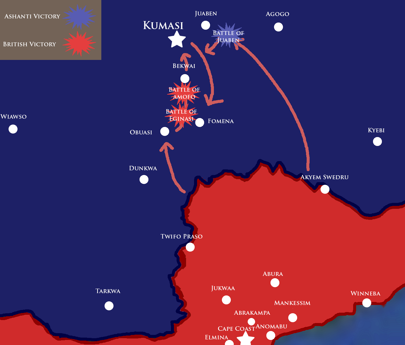
Map of showing British invasion columns and major battles
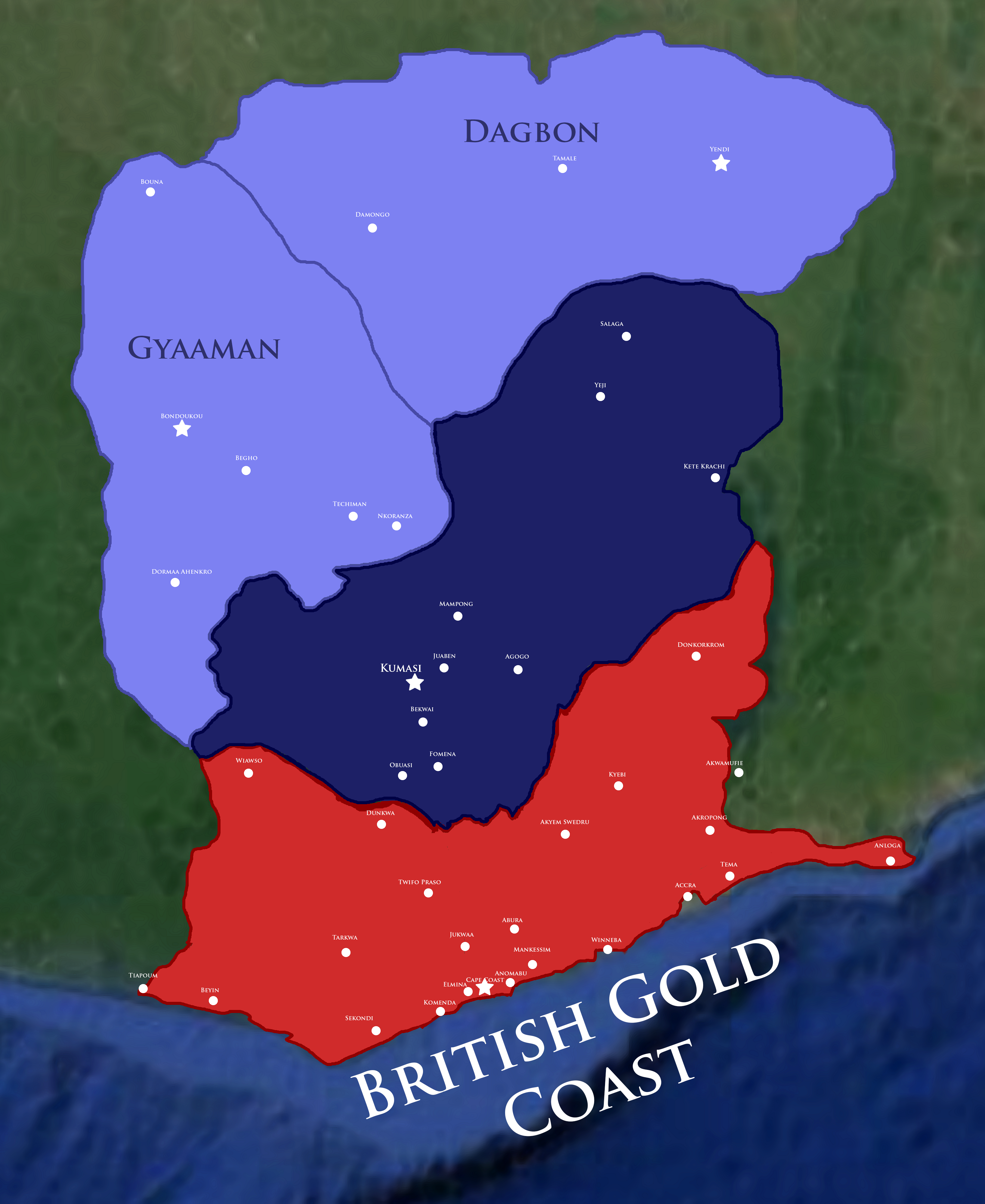
Map of Ghana after the Treaty of Fomena (1874)

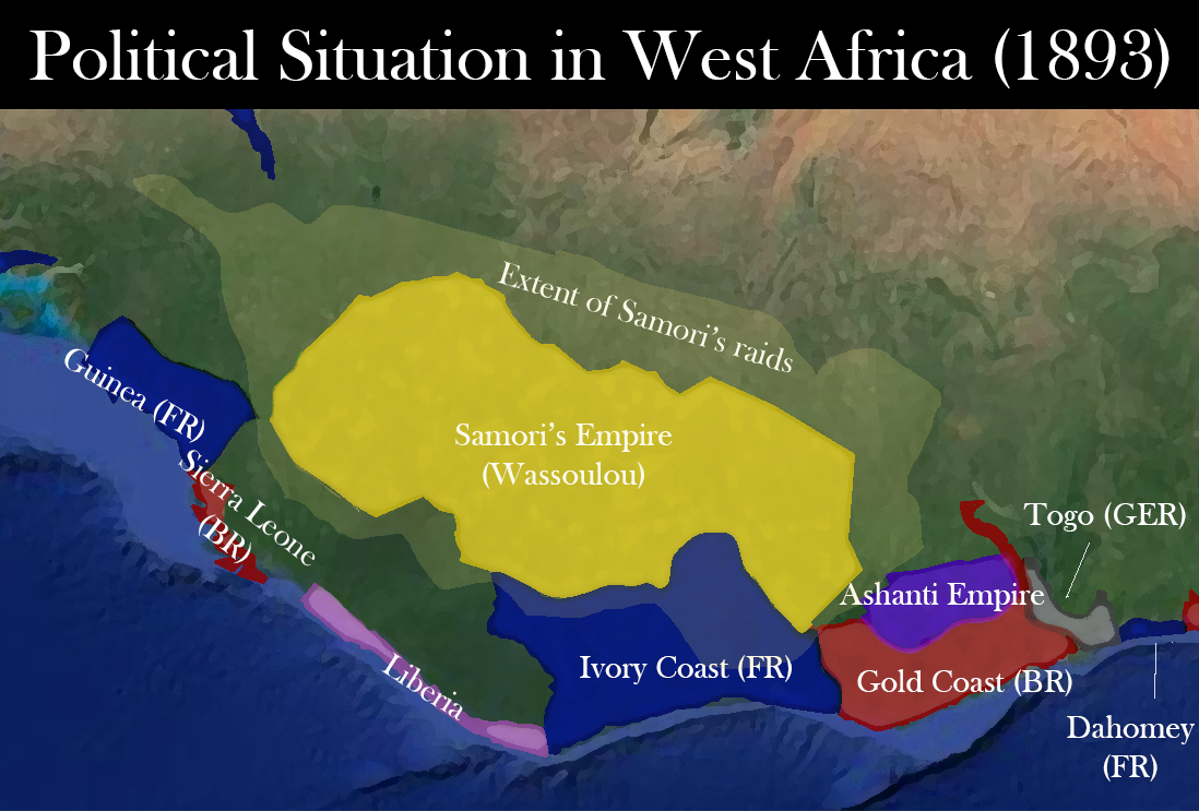
The maximum extent of the Ashanti offensive in 1873

Ghana - 1872 (After the sale of the Dutch Gold Coast + Bofour's Campaigns
Ghana - 1870

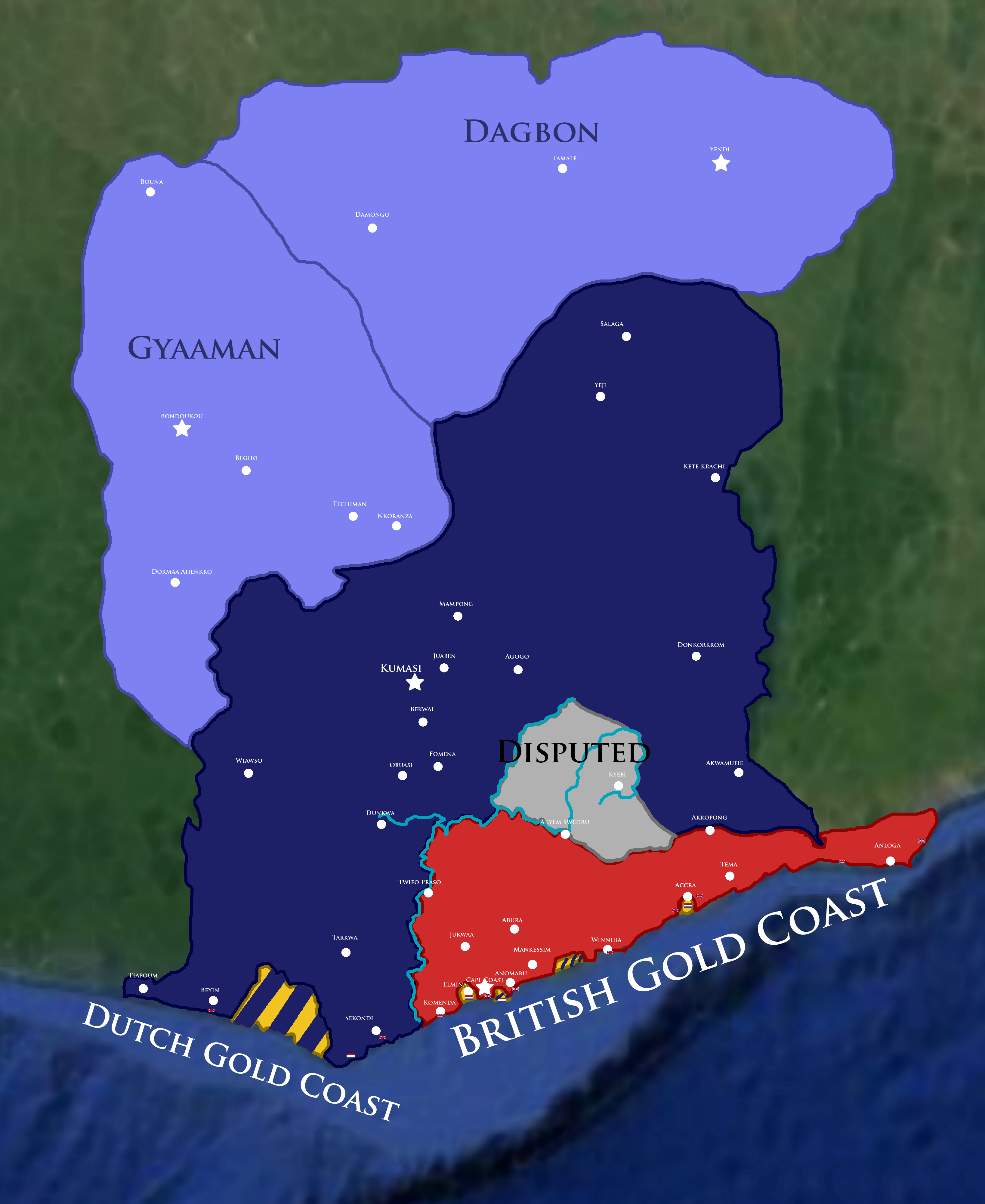
Map of Ghana in 1868
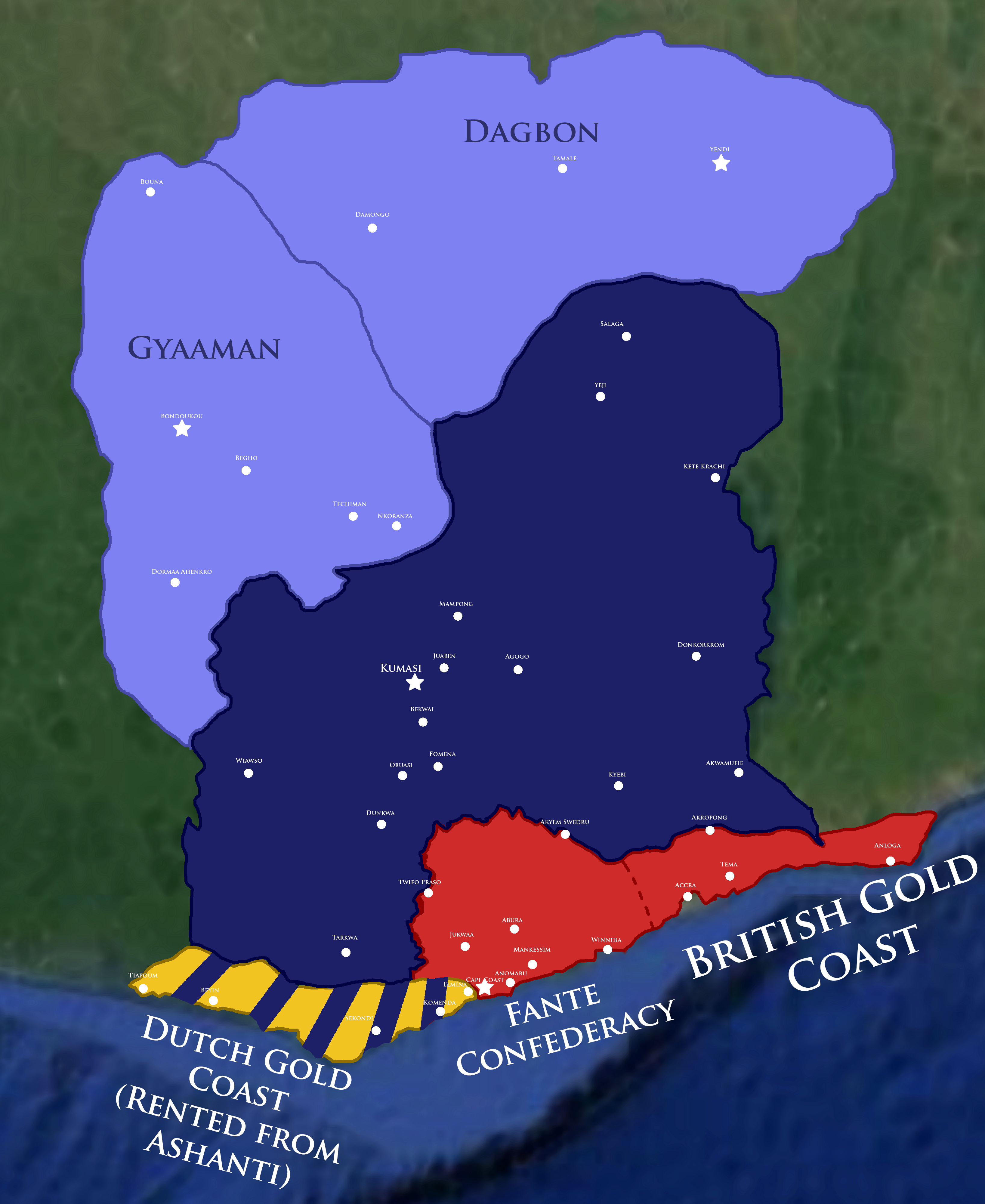
The Ashanti and their Neighbors (1850)

Map of Ghana after the First-Anglo Ashanti War

Map of Ashanti and British troop movements in the Nsamankow campaign of 1822-1823

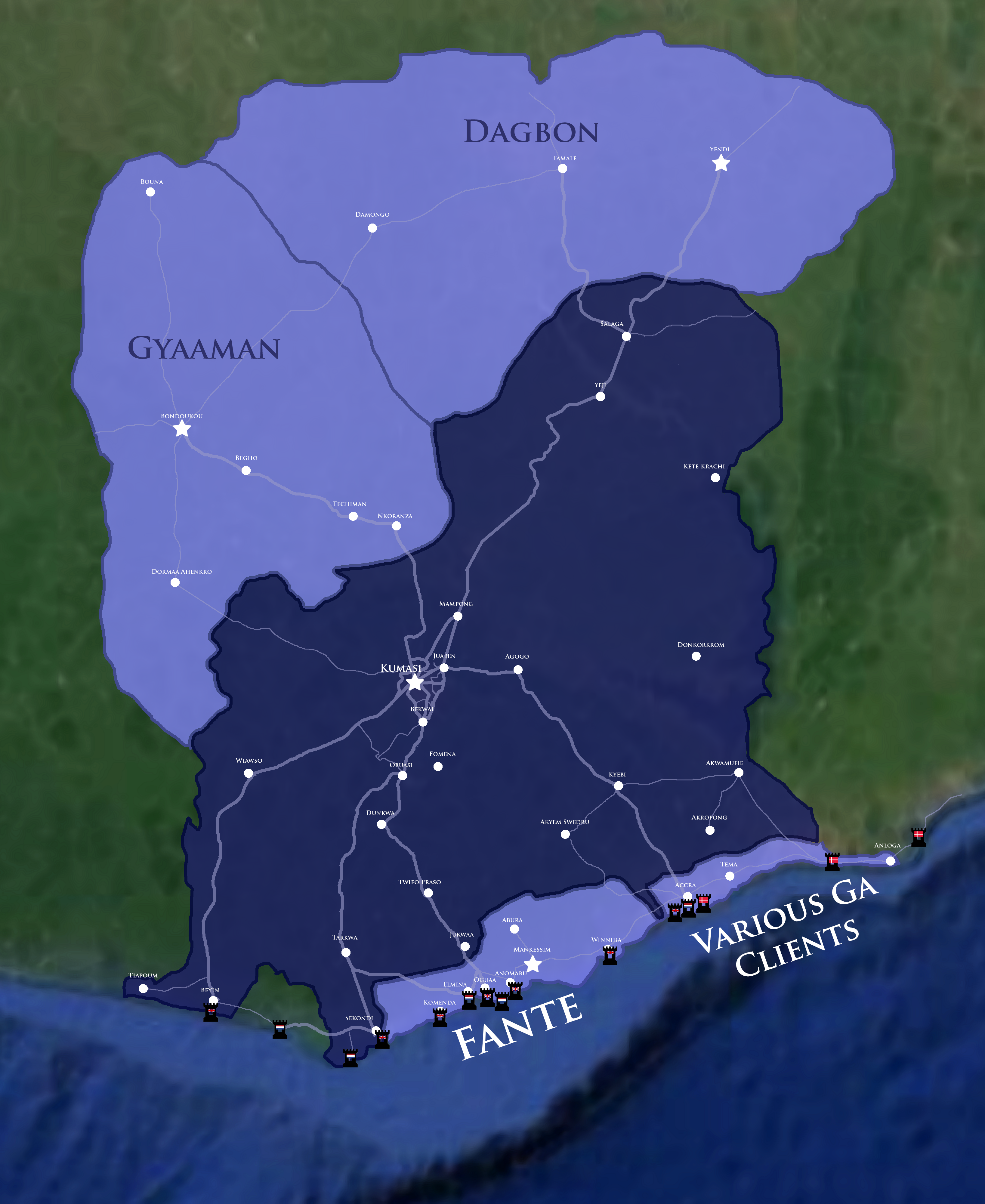
Map of the Ashanti Empire, its clients, and its road networks in 1820
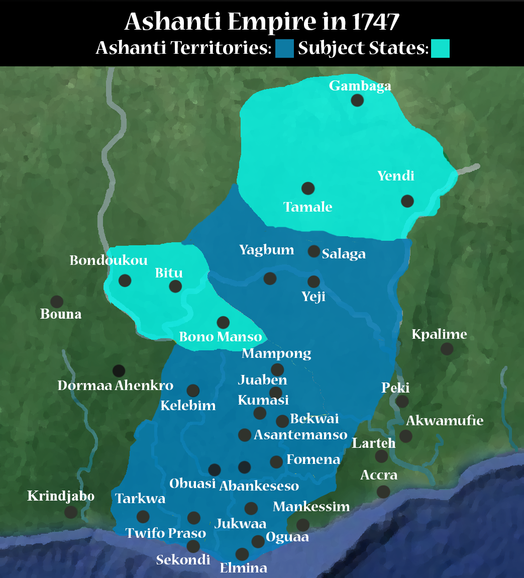
The Ashanti Empire at its height in 1818, featuring roads.


QUOTE
From
History of Africa Podcast
From Cairo to Cape Town, learn more about the History of Africa from this educational and entertaining historical podcast
historyofafricapodcast.blogspot.com
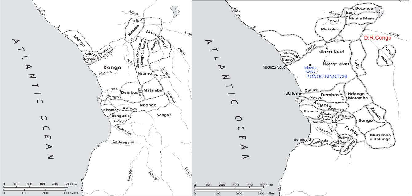
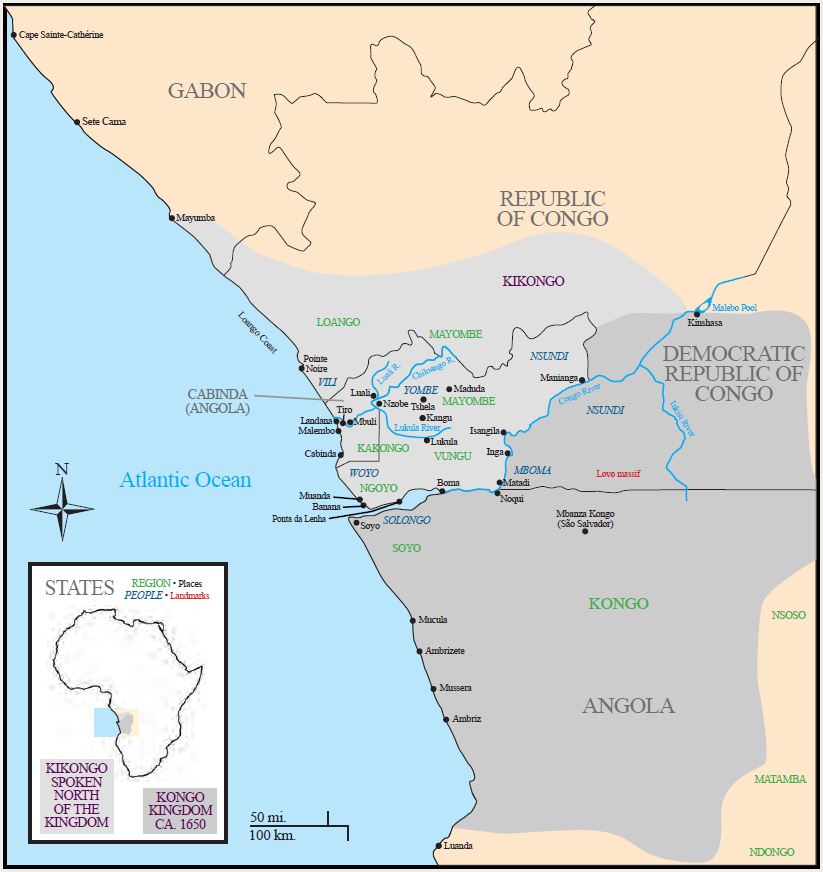
The Kongo kingdom and its six main provinces (Mpemba, Nsundi, Mbata, Soyo, Mbamba, Mpangu) in the Sixteenth to seventeenth centuries.


South-central Africa in the Later Iron Age

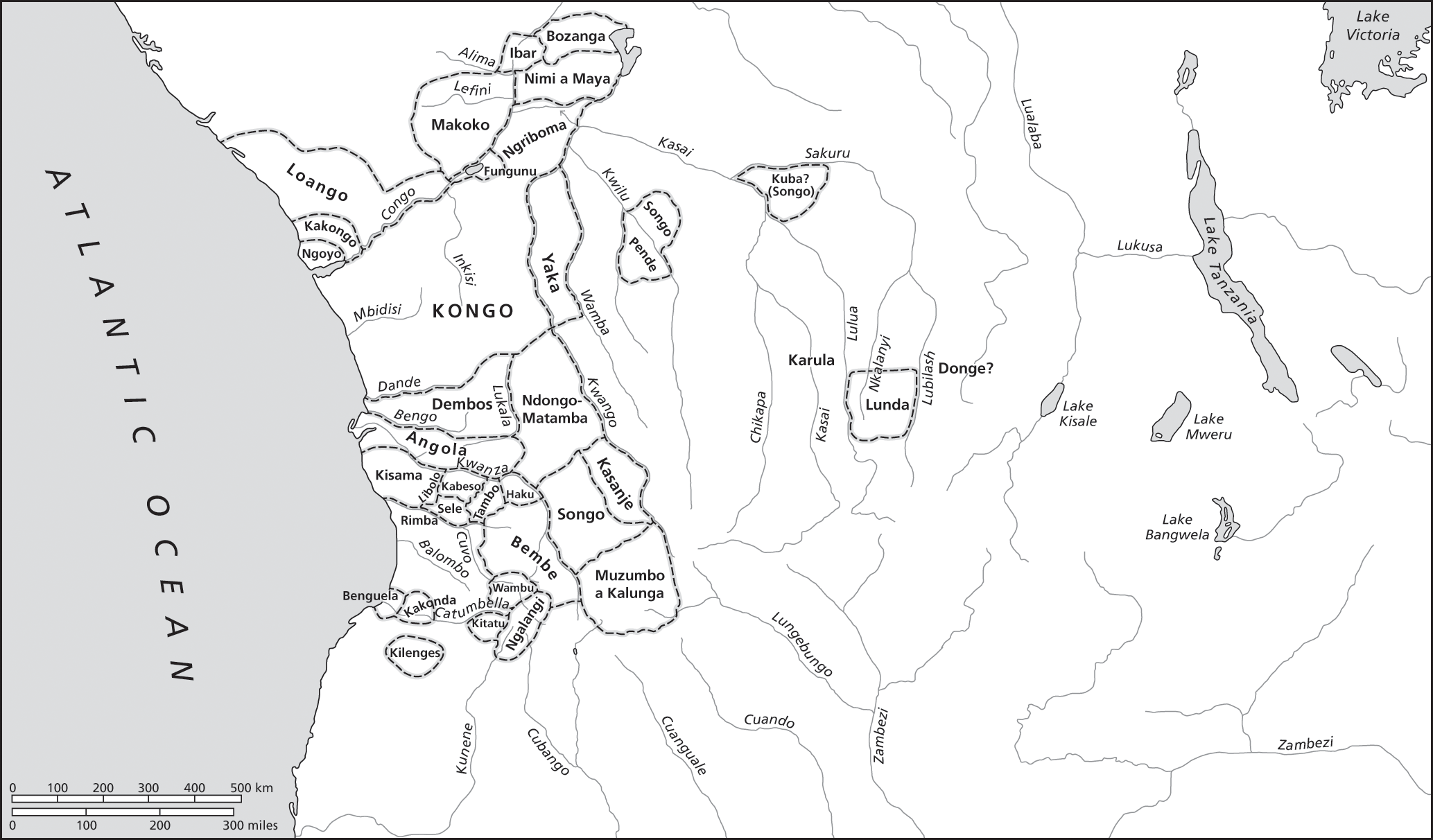
Central Africa, sixteenth to eighteenth centuries

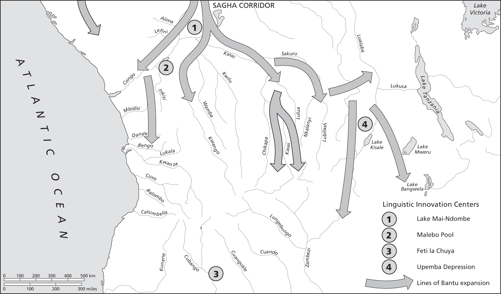
1. Peopling and Early State Formation

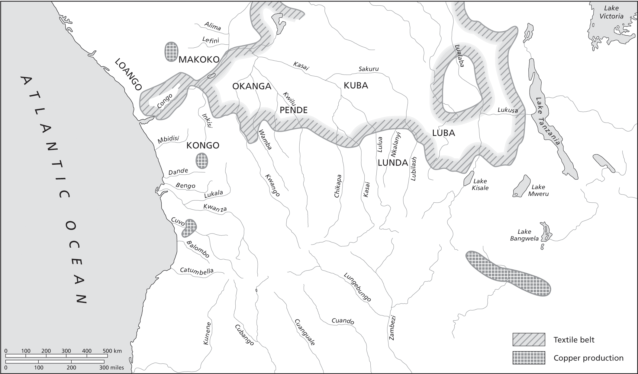
2. Economic Centers

3. Situation 1550

4. Situation 1650

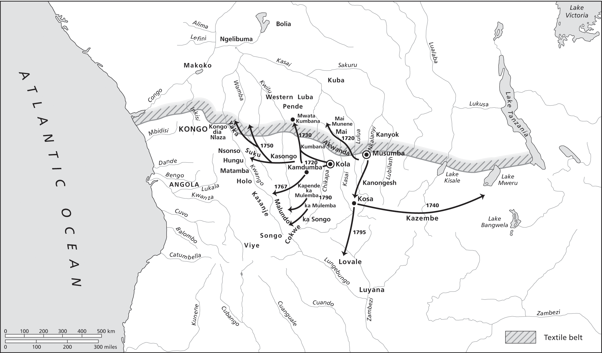
5. Expansion of the Lunda Empire

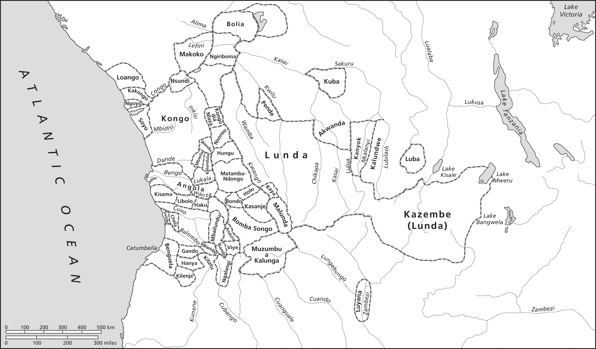
6. Situation 1750

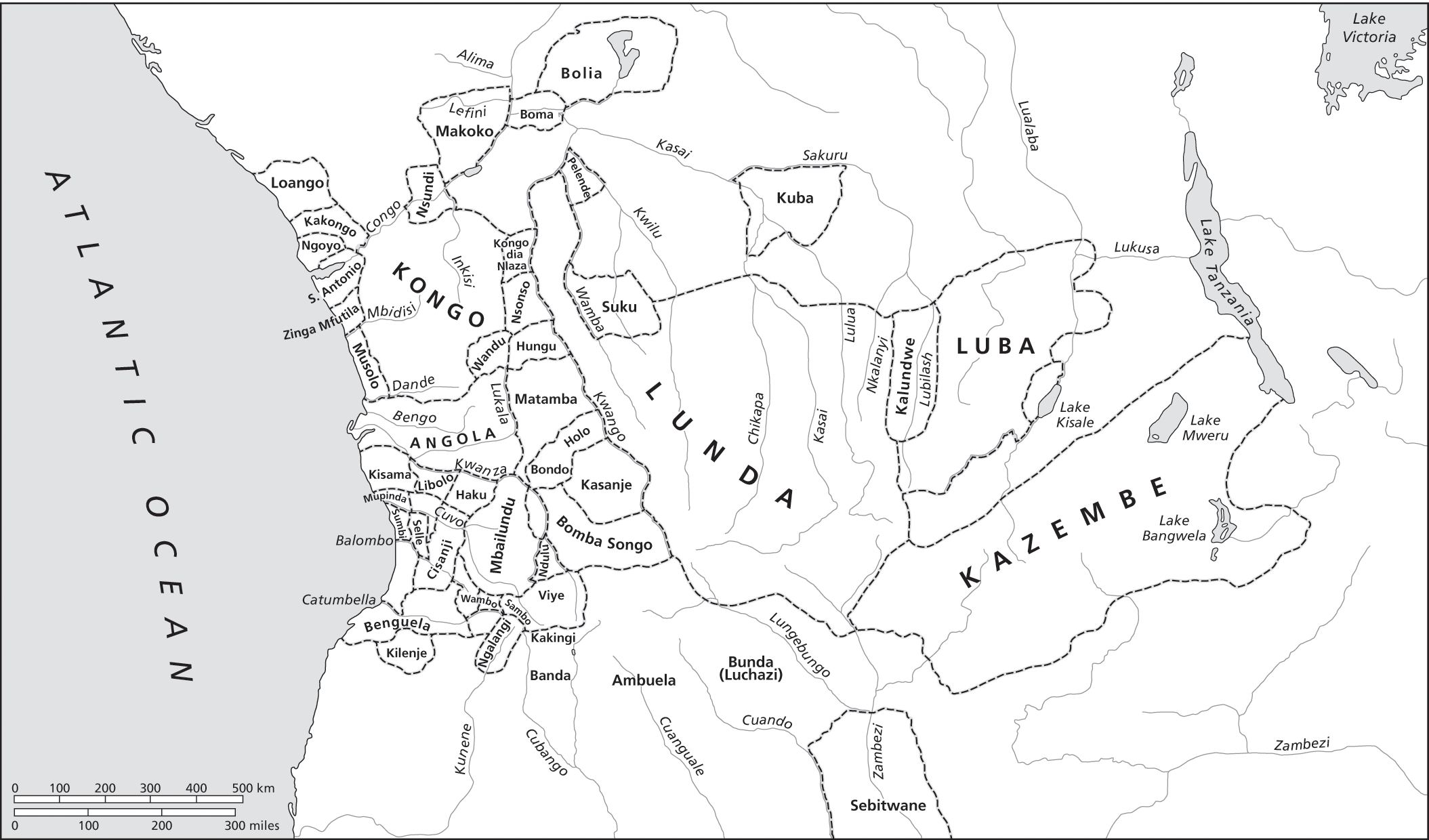
7. Situation 1850

South-central Africa in the Later Iron Age
Central Africa, sixteenth to eighteenth centuries
1. Peopling and Early State Formation
2. Economic Centers
3. Situation 1550
4. Situation 1650
5. Expansion of the Lunda Empire
6. Situation 1750
7. Situation 1850
Last edited:
Language and State, c. 1650
1648

1648

1648

1650(basically just a reworking of 1648)
1711
1711
1754

1770

1770

1864

Largely from Wikipedia and One from Crazy Boris.
Last edited:
Busy Sunday, couldn't find any real q-bams covering the Congo without Belgium being involved.
So, I took View attachment 753797from my own 1885 map, View attachment 753798 from another,
View attachment 753799 for the coast and View attachment 753800 for Congo tribes.
Put them on View attachment 753801 to produce;-
View attachment 753802
(colours are holding pattern only)
Copper croisettes and associated archeological sites across Southern Africa


Last edited:
Various Angola Maps

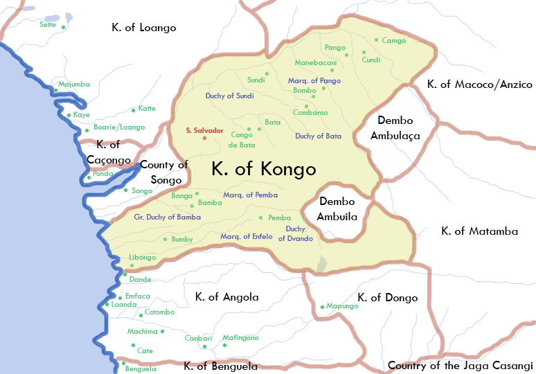
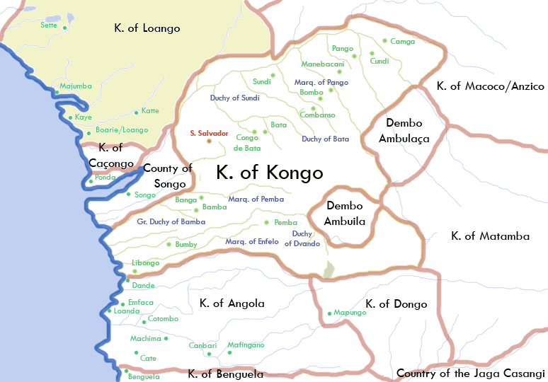
16th and 17th Century Kongo

Angola 1850 - 1870

Ngoni Kingdoms 1875

Luangwa Chiefdoms

Chewa Kingdoms

Central Africa 1800 - 1880


Zimbabwe states/cultures 900 AD - 1450 AD

Central Africa 1600 - 1800

Inner Angola Kingdoms

Companies in the Congo Free State

Pygmy groups in Central Africa

Simplified Congo Kingdoms

Congo States 1900

Congo Military Campaigns 1890 - 1895

Non-European states at around the Congo Free State ceding

16th and 17th Century Kongo
Angola 1850 - 1870
Ngoni Kingdoms 1875
Luangwa Chiefdoms
Chewa Kingdoms
Central Africa 1800 - 1880
Zimbabwe states/cultures 900 AD - 1450 AD
Central Africa 1600 - 1800
Inner Angola Kingdoms
Companies in the Congo Free State
Pygmy groups in Central Africa
Simplified Congo Kingdoms
Congo States 1900
Congo Military Campaigns 1890 - 1895
Non-European states at around the Congo Free State ceding
Last edited:
Bobandana region

Bahavu Chiefdom in 1935

Kalehe Territory

Bahavu Territory

Tyo Kingdom

Kongo Kingdom


Guinean West Central African States in 1625

"Cumulatively referred to as Kuba, the people in fact comprise unique independent chieftains. Though culturally and linguistically similar, each is an entity to itself. Joseph Cornets tribal map (above) was published in Art Royal Kuba - page 15. It details political groupings aligned to the Bushoong."


Luba Subgroups

Malawi Chiefdoms

Northern Rhodesia native and tribal reserves

Administrative divisions of Rhodesia-Nyasaland

Kivu Chiefdoms

The Pink Map

Trusts of the Belgian Congo

Anglo-German division of Portuguese colonies in Africa

Bahavu Chiefdom in 1935
Kalehe Territory
Bahavu Territory
Tyo Kingdom
Kongo Kingdom
Guinean West Central African States in 1625
"Cumulatively referred to as Kuba, the people in fact comprise unique independent chieftains. Though culturally and linguistically similar, each is an entity to itself. Joseph Cornets tribal map (above) was published in Art Royal Kuba - page 15. It details political groupings aligned to the Bushoong."
Luba Subgroups
Malawi Chiefdoms
Northern Rhodesia native and tribal reserves
Administrative divisions of Rhodesia-Nyasaland
Kivu Chiefdoms
The Pink Map
Trusts of the Belgian Congo
Anglo-German division of Portuguese colonies in Africa
Last edited:
Map 5-I: Native administration in South Darfur, 1928. Source: Private papers of Omar Ali al-Ghali, wakeel nazir of the Habbaniyya tribe


Map 3-4: Routes in Dar Masalit

Map 3-3: Seasonal migrations of the Baggara tribes in Southern Darfur

Map 3-2: Migrations of Nomadic Tribes, Northern and Western Darfur

Map No 2-I. Fur Tribe diar (hawakeer) in 1939. Source: Sudan Central Archives, Darfur Province file 2/37/288

Map 10. The Original Cokwe Territory: Peoples, Places and Trade routes before 1850

Map 11. Maximum Cokwe Expansion: Peoples, Places and Trade-Routes, c. 1890

Central Africa Republic Civil War (as of 23rd of May 2023)

Chieftains of the Tonga Plateau

West Central Africa Ethnic groups

Map 3-4: Routes in Dar Masalit
Map 3-3: Seasonal migrations of the Baggara tribes in Southern Darfur
Map 3-2: Migrations of Nomadic Tribes, Northern and Western Darfur
Map No 2-I. Fur Tribe diar (hawakeer) in 1939. Source: Sudan Central Archives, Darfur Province file 2/37/288
Map 10. The Original Cokwe Territory: Peoples, Places and Trade routes before 1850
Map 11. Maximum Cokwe Expansion: Peoples, Places and Trade-Routes, c. 1890
Central Africa Republic Civil War (as of 23rd of May 2023)
Chieftains of the Tonga Plateau
West Central Africa Ethnic groups
Last edited:

Pink: Mpongwe confederacy
Yellow: Kingdom of Orungu
Light green: Kingdom of Nkomi
Orange: Ngubi
Dark green: Kingdom of Loango
Date: 1550 A.D. to 1883 A.D., 16th century A.D., 19th century A.D. (description kindly "borrowed" from RETF)


https://www.persee.fr/doc/cea_0008-0055_1976_num_16_63_2519 Article about the babalia kingdom in chad (french)
https://www.persee.fr/doc/outre_0300-9513_1981_num_68_250_2313 Article about the Bedaya (sara) kingdom(s?) in chad (French)
Map of the sara homeland


Last edited:
Conquest of Bailundu

Predominent Of Angolan Independentist group by region in the latter phase of the Coloniak war


Close up of the sultanates of Bangassou

Second level subdivisions of the Shilluk Kingdoms
Economic Specialisation in mid-19th century Equatorial Africa

The Cuanza Basin, ca. 1575 - 1600

Civil war and banditry in Kongo, 1780s.

Predominent Of Angolan Independentist group by region in the latter phase of the Coloniak war
Luba Empire: Late Eighteenth Century to the 1860s', in Thomas Q. Reefe, The Rainbow and the Kings: A History of the Luba Empire to 1891. (University of California Press: Berkeley, 1981) p. 116.
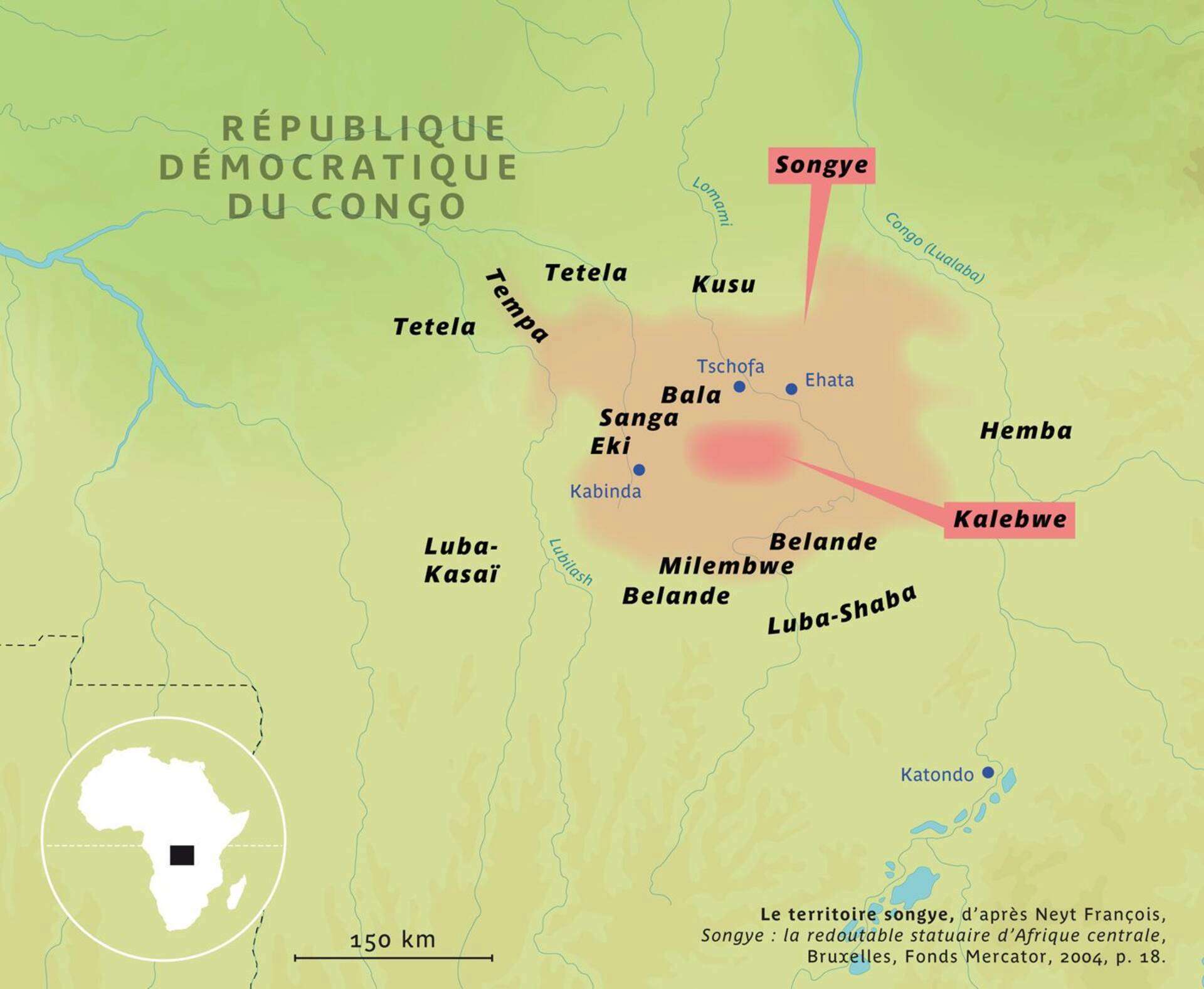
'Zappo-Zap Migration from M'Penge'. Based on 'La region Songhe Avant 1887', In Paul Timmermans 'Les Sap Sapo pres de Luluabourg'. Africa-Tervuren, Volume 8, Issue 1/2, (1962), p. 30.

The People of Eastern Angola Around 1850

Caravane routes, late 19th century

16th-17th century gabon

- Nations of the ougoue trade in the early 19th century

- Some dates of the conquest of CAR
Close up of the sultanates of Bangassou
Native reserves Zambia 1937

Second level subdivisions of the Shilluk Kingdoms
Economic Specialisation in mid-19th century Equatorial Africa
The Cuanza Basin, ca. 1575 - 1600
Civil war and banditry in Kongo, 1780s.
Last edited:
"West Central Africa c. 1500" by Kathryn J. Miller Dates: 1500 1500s 16th century Polities: Kongo Loango Kakongo Ngoyo Mpanzalumbu Vungu Mazinga Mpemba Kasi Lemba Bula Sanga Nsi Kwilu Mbata Npangu Nsundi Kundi Kongo Dia Nlaza Soyo Kiowa Kandongo Matadi Vunda Nzolo Zombo Nkubu Mbamba Mpemba Wembo Wandu "Chamgalla" Mbwela Ndongo Tags: Central Africa DRC Democratic Republic of the Congo Zaire Angola Congo Gabon African Sub-Saharan Africa https://cdn.discordapp.com/attachments/747171746335031417/769592154875101184/unknown.png
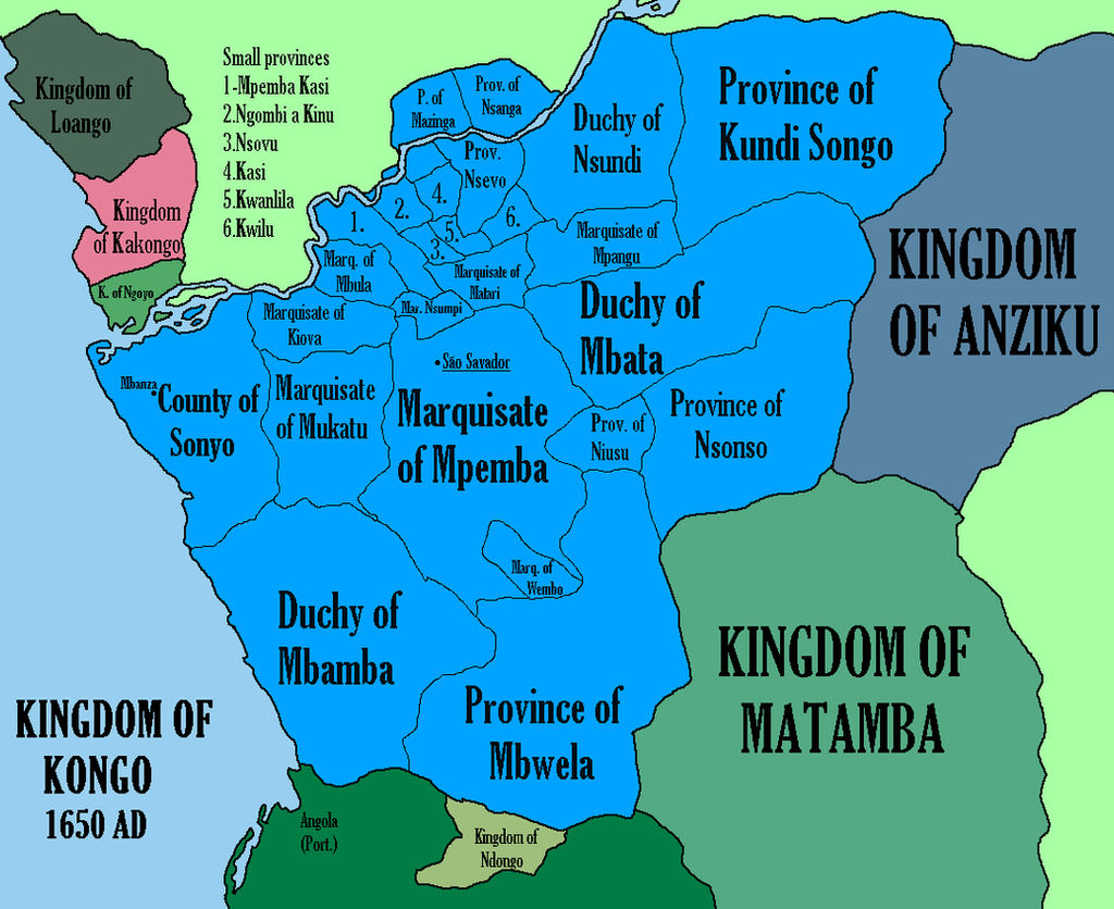
 "The kingdom of Kongo in the seventeenth century" Dates: 1600 1600s 17th century Polities: Kongo Sonyo Undi Ns Mpangu Mbata Mpemba Wembo Wandu Mbamba Angola Matamba Tags: Central Africa DRC Democratic Republic of the Congo Zaire Angola Congo Gabon African Sub-Saharan Africa https://cdn.discordapp.com/attachments/747171746335031417/769592802915909632/unknown.png

Chewa Expansion c. 1500 - 1790s
 https://eprints.soas.ac.uk/29031/1/10731125.pdf The Bimbi Cult in Southern Malawi
Archaeobotanical Investigations of the Iron Age Lundu State, Malawi https://cdn.discordapp.com/attachments/585602668085510145/822628868535222312/ChrisJStevensSa_2013_Chapter16Archaeobotan_ArchaeologyOfAfricanP.pdf
 Sultanate of Dar Masalit


 Bagirmi and neighbors

Internet Archive
Tippoo Tib Ath Story Of His Career In Central Africa : Heinrich Bro...
Book Source: Digital Library of India Item 2015.72620dc.contributor.author: Heinrich Brodedc.date.accessioned: 2015-06-30T13:23:40Zdc.date.available:...
A WINDOW ON ZAMBIA
Gill Staden
Kingdoms of Zambia | A WINDOW ON ZAMBIA
Share this:TwitterFacebookLike this:Like Loading...
40341608.pdf
1.40 MB
 Chikunda conquest states, 1880s
Beti-Pahoun migrations
 Capuchin parishes in Soyo (province of Kongo), 17th century
 Nzebi Expansions


Chewa Expansion c. 1500 - 1790s
Archaeobotanical Investigations of the Iron Age Lundu State, Malawi https://cdn.discordapp.com/attachments/585602668085510145/822628868535222312/ChrisJStevensSa_2013_Chapter16Archaeobotan_ArchaeologyOfAfricanP.pdf
Darfur-Wadai
Bagirmi
https://archive.org/details/in.ernet.dli.2015.72620/page/n3/mode/2upInternet Archive
Tippoo Tib Ath Story Of His Career In Central Africa : Heinrich Bro...
Book Source: Digital Library of India Item 2015.72620dc.contributor.author: Heinrich Brodedc.date.accessioned: 2015-06-30T13:23:40Zdc.date.available:...
kingdoms of zambia (borders aren't perfect) https://awindowonzambia.com/kingdoms-of-zambia/A WINDOW ON ZAMBIA
Gill Staden
Kingdoms of Zambia | A WINDOW ON ZAMBIA
Share this:TwitterFacebookLike this:Like Loading...
Article about the babalia kingdom in chad (french)40341608.pdf
1.40 MB
https://web.archive.org/web/20180203191542/http://goto.glocalnet.net/mahopapers/nuglonline.pdf resource on bantu languages locations
Map of Malawi showing areas of Chikunda influence (19th century)
Owen J. M. Kalinga (1984). Towards a Better Understanding of Socio-Economic Change in 18th- and 19th-Century Ungonde.
Main axis of conquest of angola with dates of battle and occupation
Last edited:
Economic map of Angola 1910 (lots of ressources like diamond or oil weren't exploited yet, and slave labour was still widely used for Sao tomé's plantations, in angolan plantation or as porters) 5: Sugarcane 6: Coffee 7: Slaves 8: Slaves & Rubber 9: Cotton 10: Fishing ports

 Ethnic map of Angola (60s)
 Soil, Concession and land ownership maps of colonial Zambia
 Barotseland at the end of Lewanika's reign (1900s)
 Ethnic groups of the Tabwa area
 Geography, Ethnography and Economics of Southern angola, late 19th to early 20th
Northern Rhodesia native reserves and tribal areas (1934)

Last edited:
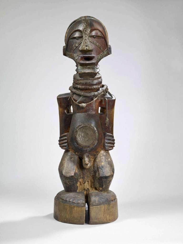
Nkishi protective statue
This large male nkishi statue protected the clan and its chief thanks to its magical and religious powers. Its power is shown in the vitality of its gaze, the protruding mouth and its features inlaid with metal. The neck is draped in necklaces covered in snakeskin. Fish hooks hang from them...
 collection-lacharriere.quaibranly.fr


Akan, Ge, and Ewe
 Yoruba Trade Routes
 Benin Expansion
 Baule Trade Patterns
 Benin
Benin
 Benin
Benin
 Benin 1400s
 Bassar
 Bassar Iron Trade
 Bornu
Bornu
 Bornu Salt
 Kanem-Bornu and neighbors
 Borgu Kingdom
 Dahomey and its conquest of Allada and Hueda

Last edited:
Trade routes in Benue
 Bornu 1810

Grassfields Ethnic
 Abutia (Abutia is a traditional area in Ghana with Teti, Agorve and Kloe)

Abuja and Fulani Zazzau
 Gyaman Kingdom
 Gobir
Gobir
 Nupe
Nupe
 Bight of Benin 1840
 Burkina Faso in the 19th century
 Ivory Coast Ethnic
 Sokoto
 Dahomey Expansion
 Niger Delta City States
 Igbo groups
 Dutch gold Coast 1600s

Grassfields Ethnic
Abuja and Fulani Zazzau
Last edited:
Edo groups

Slave Coast Complexes
 Akan Frontier States

Nupe Language Groups
 Gold Coast
 Gao Refromist Communities
 German Togoland Expedition

Gold Coast
 Kom People migrations (Grasslands Kingdoms)
 Ashanti Gold Trade
 Grasslands Kingdoms, Kingdom of Kom
 Grasslands Kingdoms, Source: An Outline of the Traditional Political System of Bali-Nyonga (North West Cameroon)

Igboland sub-cultures
 Igbo Trade Routes
 Igbo Centers
 Yoruba Frontier States
 Sahel 18th and 19th century

Jula Population Centers
 Kanem-Bornu Empire 17th and 18th century
 Kanem-Bornu Empire 1570-1600
Slave Coast Complexes
Nupe Language Groups
Gold Coast
Igboland sub-cultures
Jula Population Centers
Last edited:
Source.
Oyo Civil War 1816


Last edited:
Share: