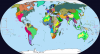
I have created a map of some of the world of the ASB and PIC prior to World War 1 :
EDIT : fixed a few errors
EDIT EDIT : fixed three more errors
EDIT EDIT EDIT : fixed Italy-Cisleithania border
EDIT EDIT EDIT EDIT : fixed Patagonia
EDIT EDIT EDIT EDIT EDIT : fixed Cisleithania-Transleithania border, French Guinea's western border, Southwest Africa-Barotseland border, Tangier and Malta.

[not shown : Boer, Griqua, Baster, etc. protectorates in Sudafrique, Basouana and Southwest Africa and possibly also other places as well]
I apologise for the convergent borders in Southern Africa, Peru and Germany. I also apologise for not drawing in the various princely states in Anglo-Omani-Zanzibari-Tanganyika (thanks Jonathan Edelstein)
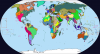
EDIT : fixed a few errors
EDIT EDIT : fixed three more errors
EDIT EDIT EDIT : fixed Italy-Cisleithania border
EDIT EDIT EDIT EDIT : fixed Patagonia
EDIT EDIT EDIT EDIT EDIT : fixed Cisleithania-Transleithania border, French Guinea's western border, Southwest Africa-Barotseland border, Tangier and Malta.
[not shown : Boer, Griqua, Baster, etc. protectorates in Sudafrique, Basouana and Southwest Africa and possibly also other places as well]
I apologise for the convergent borders in Southern Africa, Peru and Germany. I also apologise for not drawing in the various princely states in Anglo-Omani-Zanzibari-Tanganyika (thanks Jonathan Edelstein)
Last edited: